EP4242986A1 - Method and system to detect and estimate dynamic obstacles using rgbd sensors for robot navigation - Google Patents
Method and system to detect and estimate dynamic obstacles using rgbd sensors for robot navigation Download PDFInfo
- Publication number
- EP4242986A1 EP4242986A1 EP22208864.3A EP22208864A EP4242986A1 EP 4242986 A1 EP4242986 A1 EP 4242986A1 EP 22208864 A EP22208864 A EP 22208864A EP 4242986 A1 EP4242986 A1 EP 4242986A1
- Authority
- EP
- European Patent Office
- Prior art keywords
- obstacle
- depth map
- depth
- obstacles
- dynamic
- Prior art date
- Legal status (The legal status is an assumption and is not a legal conclusion. Google has not performed a legal analysis and makes no representation as to the accuracy of the status listed.)
- Withdrawn
Links
Images


Classifications
-
- G—PHYSICS
- G06—COMPUTING OR CALCULATING; COUNTING
- G06V—IMAGE OR VIDEO RECOGNITION OR UNDERSTANDING
- G06V20/00—Scenes; Scene-specific elements
- G06V20/50—Context or environment of the image
- G06V20/56—Context or environment of the image exterior to a vehicle by using sensors mounted on the vehicle
- G06V20/58—Recognition of moving objects or obstacles, e.g. vehicles or pedestrians; Recognition of traffic objects, e.g. traffic signs, traffic lights or roads
-
- B—PERFORMING OPERATIONS; TRANSPORTING
- B25—HAND TOOLS; PORTABLE POWER-DRIVEN TOOLS; MANIPULATORS
- B25J—MANIPULATORS; CHAMBERS PROVIDED WITH MANIPULATION DEVICES
- B25J9/00—Programme-controlled manipulators
- B25J9/16—Programme controls
- B25J9/1656—Programme controls characterised by programming, planning systems for manipulators
- B25J9/1664—Programme controls characterised by programming, planning systems for manipulators characterised by motion, path, trajectory planning
- B25J9/1666—Avoiding collision or forbidden zones
Definitions
- the disclosure herein generally relates to obstacle detection, and, more particularly, to method and system to detect and estimate dynamic obstacles using RGBD sensors for robot navigation.
- Service robots are envisioned to support humans in a variety of monitoring activities such as fetching and carrying objects. Therefore, robots are equipped with a sensor setup that allows close and safe interaction with obstacles while navigating through monitoring environments. Common to these application robot should be able to navigate in a cluttered 3D environment, to detect and recognize obstacles.
- obstacle detection and tracking is an active research area for its applicability to autonomous driving or navigation. Obstacle detection is an important task for autonomous navigation of robots. Here, the task becomes more complex in dynamic and cluttered environments.
- RGBD camera is one of the most common devices that provides a quick and good estimation of the environment in the form of RGB and depth images. Efficient processing of depth image is crucial for obstacle detection and tracking.
- RGBD camera for example RealSense D400 ®
- MAV Micro Aerial Vehicle
- a depth map is converted to a point cloud, the planer road is segmented out and all leftover points are considered as obstacles.
- This approach differentiates static and dynamic obstacles using the DECOLOR algorithm and demands high computations to process point cloud and unfit for MAV.
- a system to detect and estimate dynamic obstacles using RGBD sensors for robot navigation includes capturing one or more depth images using a depth camera module including a RGBD sensor configured to a mobile robot navigating through a monitoring environment and constructing a u-depth map using the one or more depth images.
- the obstacle detection module detects one or more obstacles comprising of atleast one of a static or a dynamic in two dimensional space using the u-depth map by, (i) converting, the u-depth map into binary images based on a dynamic threshold using an image processing technique, (ii) estimating, a width of each obstacle based on the width of segmented white patch from the u-depth map, and (iii) estimating, a depth range of each obstacle between a minimum and a maximum row index of the segmented white patch from the u-depth map.
- the obstacle detection module computes height of obstacle from a restricted v-depth map between specified columns taken from the width of each obstacle of the u-depth map and within the depth range derived from the u-depth map, and a height of each obstacle from the restricted v-depth map, and transform the height and width of one or more obstacles from the two dimensional image coordinates into a three-dimensional camera coordinates c.
- the obstacle tracking module creates signatures of each obstacle from their appearances in the u-depth map.
- the obstacle tracking module further tracks the one or more obstacles by matching closeness of signatures of detected obstacles on subsequent u-depth images.
- the dynamic obstacle estimation module estimates the dynamic obstacles by converting the obstacles identified in the three-dimensional camera coordinates c into a world coordinate w and identifying dynamic obstacles based on velocity estimation is above to a predefined threshold value.
- the velocities of dynamic obstacles are used to predict future positions of dynamic obstacles in the region of the monitoring environment.
- the restricted v-depth map estimates accurate height of each obstacle.
- the obstacles are tracked by comparing structural properties of obstacle appearance in the u-depth map by creating a signature of obstacle patch in the u-depth map, and iteratively for the one or more obstacles a closeness signature is searched within neighboring vicinity based on a shape alignment of each obstacle.
- the signature is the shape alignment of obstacle in a u-depth map which is formed with a set of vectors and a centroid.
- the vectors are formed with pixels that are taken from the contour of the obstacle in u-depth map.
- the centroid is the average coordinate position of all pixels that are taken from the contour of the obstacle in u-depth map.
- the closeness of signatures is computed with the sum of differences derived between vectors of obstacle's signature identified in the previous depth image and the vectors of obstacle's signature identified in the next depth image starting from minimum column index.
- difference between vectors is computed with a sum of angle difference and squared length difference.
- a method for detecting and estimating dynamic obstacles using RGBD sensors for robot navigation includes capturing one or more depth images using a depth camera module including a RGBD sensor configured to a mobile robot navigating through a monitoring environment and constructing a u-depth map using the one or more depth images.
- the obstacle detection module detects one or more obstacles comprising of atleast one of a static or a dynamic in two dimensional space using the u-depth map by, (i) converting, the u-depth map into binary images based on a dynamic threshold using an image processing technique, (ii) estimating, a width of each obstacle based on the width of segmented white patch from the u-depth map, and (iii) estimating, a depth range of each obstacle between a minimum and a maximum row index of the segmented white patch from the u-depth map.
- the obstacle detection module computes height of obstacle from a restricted v-depth map between specified columns taken from the width of each obstacle of the u-depth map and within the depth range derived from the u-depth map, a height of each obstacle from the restricted v-depth map, and transform the height and width of one or more obstacles from the two dimensional image coordinates into a three-dimensional camera coordinates c .
- the obstacle tracking module creates signatures of each obstacle from their appearances in the u-depth map.
- the obstacle tracking module further tracks the one or more obstacles by matching closeness of signatures of detected obstacles on subsequent u-depth images.
- the dynamic obstacle estimation module estimates the dynamic obstacles by converting the obstacles identified in the three-dimensional camera coordinates c into a world coordinate w and identifying dynamic obstacles based on velocity estimation is above to a predefined threshold value.
- the velocities of dynamic obstacles are used to predict future positions of dynamic obstacles in the region of the monitoring environment.
- a non-transitory computer readable medium provides one or more non-transitory machine-readable information storage mediums comprising one or more instructions, which when executed by one or more hardware processors perform actions includes an I/O interface and a memory coupled to the processor is capable of executing programmed instructions stored in the processor in the memory to capture one or more depth images using a depth camera module including a RGBD sensor configured to a mobile robot navigating through a monitoring environment and constructing a u-depth map using the one or more depth images.
- a depth camera module including a RGBD sensor configured to a mobile robot navigating through a monitoring environment and constructing a u-depth map using the one or more depth images.
- the obstacle detection module detects one or more obstacles comprising of atleast one of a static or a dynamic in two dimensional space using the u-depth map by, (i) converting, the u-depth map into binary images based on a dynamic threshold using an image processing technique, (ii) estimating, a width of each obstacle based on the width of segmented white patch from the u-depth map, and (iii) estimating, a depth range of each obstacle between a minimum and a maximum row index of the segmented white patch from the u-depth map.
- the obstacle detection module computes height of obstacle from a restricted v-depth map between specified columns taken from the width of each obstacle of the u-depth map and within the depth range derived from the u-depth map, a height of each obstacle from the restricted v-depth map, and transform the height and width of one or more obstacles from the two dimensional image coordinates into a three-dimensional camera coordinates c .
- the obstacle tracking module creates signatures of each obstacle from their appearances in the u-depth map.
- the obstacle tracking module further tracks the one or more obstacles by matching closeness of signatures of detected obstacles on subsequent u-depth images.
- the dynamic obstacle estimation module estimates the dynamic obstacles by converting the obstacles identified in the three-dimensional camera coordinates c into a world coordinate w and identifying dynamic obstacles based on velocity estimation is above to a predefined threshold value.
- the velocities of dynamic obstacles are used to predict future positions of dynamic obstacles in the region of the monitoring environment.
- Embodiments herein provide a method and system to detect and track dynamic obstacles using RGBD sensors for robot navigation.
- the system herein may be alternatively referred as obstacle detection and tracking system 100.
- the system 100 includes a robot that comprises a RGBD sensor to obtain one or more depth images with an independent two-axis or three-axis degree of freedom to detect and track a target, e.g. a person or an obstacle or point of interest, with the RGBD camera independently of an actual flight direction or actual attitude of the robot.
- the method enables efficient processes of depth images for obstacle detection and tracking through the RGBD camera configured to the robot navigating in a monitoring environment.
- the system 100 facilitates detection and quickly tracking and estimating of dynamic obstacles in subsequent frames of the monitoring environment for stable autonomous navigation.
- FIG. 1 through FIG.7 where similar reference characters denote corresponding features consistently throughout the figures, there are shown preferred embodiments and these embodiments are described in the context of the following exemplary system and/or method.
- FIG.1 illustrates an exemplary system 100 (alternatively referred as dynamic obstacle detection and tracking system), in accordance with some embodiments of the present disclosure.
- the system 100 includes one or more hardware processors 104, communication interface device(s) or input/output (I/O) interface(s) 106 (also referred as interface(s)), and one or more data storage devices or memory 102 operatively coupled to the one or more hardware processors 104.
- the one or more processors 104 may be one or more software processing components and/or hardware processors.
- the hardware processors can be implemented as one or more microprocessors, microcomputers, microcontrollers, digital signal processors, central processing units, state machines, logic circuitries, and/or any devices that manipulate signals based on operational instructions.
- the processor(s) is/are configured to fetch and execute computer-readable instructions stored in the memory.
- the system 100 can be implemented in a variety of computing systems, such as laptop computers, notebooks, hand-held devices, workstations, mainframe computers, servers, a network cloud, and the like.
- the I/O interface device(s) 106 can include a variety of software and hardware interfaces, for example, a web interface, a graphical user interface, and the like and can facilitate multiple communications within a wide variety of networks N/W and protocol types, including wired networks, for example, LAN, cable, etc., and wireless networks, such as WLAN, cellular, or satellite.
- the I/O interface device(s) can include one or more ports for connecting a number of devices to one another or to another server.
- the memory 102 may include any computer-readable medium known in the art including, for example, volatile memory, such as static random-access memory (SRAM) and dynamic-random access memory (DRAM), and/or non-volatile memory, such as read only memory (ROM), erasable programmable ROM, flash memories, hard disks, optical disks, and magnetic tapes.
- volatile memory such as static random-access memory (SRAM) and dynamic-random access memory (DRAM)
- non-volatile memory such as read only memory (ROM), erasable programmable ROM, flash memories, hard disks, optical disks, and magnetic tapes.
- the memory 102 further comprises (or may further comprise) information pertaining to input(s)/output(s) of each step performed by the systems and methods of the present disclosure. In other words, input(s) fed at each step and output(s) generated at each step are comprised in the memory 102 and can be utilized in further processing and analysis.
- FIG. 2 is a functional block diagram of robust dynamic obstacle detection and tracking using RGBD cameras mounted on robot being navigating monitoring environment using the system of FIG.1 , in accordance with some embodiments of the present disclosure.
- FIG. 2 includes a plurality of modules comprising a depth camera module 202, an obstacle detection module 204, an obstacle tracking module 206, a dynamic obstacle estimation module 208, and a visual inertial odometry module 210,
- the depth camera module 202 captures one or more depth images using a RGBD sensor configured to a mobile robot which navigates through a monitoring environment.
- the obstacle detection module 204 detects obstacle being identified in the monitoring environment using the depth images captured via the RGBD sensor.
- the obstacle tracking module 206 tracks the detected obstacles in subsequent images.
- the dynamic obstacle estimation module 208 identifies dynamic obstacles, estimates velocities of dynamic obstacles and predicts future positions within a predicted zone of the environment being monitored.
- the velocity estimation is computed in the world coordinate frame w .
- FIG. 3A and FIG.3B illustrates an exemplary flow diagram illustrating a method to detect and track dynamic obstacles being identified in the monitoring environment using the system of FIG.1 , in accordance with some embodiments of the present disclosure.
- the live video streaming system 100 comprises one or more data storage devices or the memory 102 operatively coupled to the processor(s) 104 and is configured to store instructions for execution of steps of the method 300 by the processor(s) or one or more hardware processors 104.
- the steps of the method 300 of the present disclosure will now be explained with reference to the components or blocks of the live video streaming system 100 as depicted in FIG.2 through FIG.7 .
- the one or more hardware processors 104 capture one or more depth images using a RGBD sensor configured to a mobile robot navigating through a monitoring environment and construct a u-depth map using the one or more depth images.
- a RGBD sensor configured to the mobile robot obtains the one or more depth images ( FIG.4A ) of the navigating region associated with the monitoring environment by using a depth camera module 202.
- the u-depth map is constructed using the one or more depth images.
- the one or more hardware processors 104 detect one or more obstacles comprising of atleast one of a static and a dynamic (e.g., static obstacle(s) or a dynamic obstacle(s)) in two-dimensional (2D) space using the u-depth map.
- the one or more depth images are processed to detect one or more obstacles being identified in the monitoring environment by using an obstacle detection module 204. Referring now to FIG.4B , where from the depth images captured via the RGBD camera detects atleast one static obstacle and dynamic obstacle in the point cloud.
- the constructed u-depth map is a column-wise histogram representation of depth values from each depth image.
- a total number of bins is N and the sensor range is up to depth d .
- Range of each bin is d / N and the resolution of u-depth map is W ⁇ N.
- the depth bins are on growing order from top to bottom in the u-depth map which means the row i corresponds to smaller depth than row j, ⁇ i ⁇ j.
- the depth bin corresponding to the obstacles becomes high and visible as white horizontal patches.
- the dimension of white horizontal patch provides corresponding obstacle's position and size with the segment these white patches in the u-depth map.
- the u-depth map is converted into binary images based on a dynamic threshold using an image processing technique.
- one or more basic image processing operations are performed on the u-depth map to achieve stable segmentation
- the first operation is computing binary thresholding where threshold value is dynamic and is represented as T row ⁇ uDImg row , means proportional with distance and provides more important to closer objects even with smaller size.
- the depth map is determined using a RealSense D435i ® where the depth estimation is noisy and thus the u-depth map also contains some noise which makes these white patches discontinuous and very often a single obstacle can appear as two different obstacles.
- a closing operation is performed on these white patches which essentially runs on a very small number of pixels and produces continuous patches quickly.
- intensive morphological operations on the entire u-depth image are excluded for fast execution.
- the segment of these white horizontal patches are segmented by connected component analysis that provides a bounding box around the white horizontal patches as shown in FIG.5A through FIG.5D .
- a width of each dynamic obstacle is estimated based on the width of segmented white patch from the u-depth map. Then, a depth range of each obstacle is estimated between a minimum and a maximum row index of the segmented white patch from the u-depth map.
- the one or more hardware processors 104 compute, a restricted v-depth map which is a row wise histogram of depth values from depth image obtained between specified columns taken from the width of each dynamic obstacle of the u-depth map and within the depth range derived from the u-depth map by using an obstacle detection module 204.
- the obstacle detection module 204 estimates a height of each obstacle from the restricted v-depth map, and transforms the height and width of one or more obstacles from the two dimensional image coordinates into a three-dimensional camera coordinates c.
- three dimensional parallelepiped shape of the one or more obstacles are determined with three dimensions size represented as ( c dim h , c dim w , c dim d ) and three dimensional position ( c P x , c P y , c P z ), where c denotes the camera coordinate frame.
- FIG.4A and FIG.5A which illustrates the example RGBD camera image with obstacles and its annotations to compute the dimensions of the bounding box around an obstacle on the depth map using the dimensions of the segmented white patch on the corresponding u-depth map.
- the width of the corresponding rectangle on the u-depth map is the same as u w because the u-depth map contains a column-wise histogram, therefore the width remains the same.
- the height of the corresponding rectangle is the minimum and maximum row wise pixels that are having depth within the depth range d min and d max values are obtained. Further, the d min and d max values from the corresponding depth bin of u t and ( u t + u h ) respectively.
- Existing methods in the literature estimate height of an obstacle on depth image using the above mentioned technique, but this estimation holds true only if there is only one obstacle within column u l and ( u l + u w ) and the depth range between d max to d min .
- FIG.5A and FIG.5C illustrates one such wrong height estimation of obstacle (with a tall bounding box) by calculating height from the top most and bottom most coordinates points present on the depth images within column ranges u l and ( u l + u w ) and within the depth ranges d max to d min which is known in the state of the art.
- the wrong height estimation occurs when multiple obstacles present within the above mentioned column ranges and depth ranges.
- State of the art methods estimate a combined height of all obstacles present within the above mentioned column ranges and depth ranges.
- FIG.5C represents the restricted v-depth map that found another small obstacle on the top which is illustrated in a magnified view in FIG.5D .
- the present method of the disclosure is evaluated for the indoor open sequences analysis shows market sequence of Open LORIS-Scene dataset.
- the dataset environment is a real-world departmental shop in indoor lighting conditions with multiple dynamic and static obstacles.
- the RGBD image is of 848x480 @30 Hz.
- FIG.4A shows one such snapshot where the system tracks dynamic obstacle and calculates its velocity.
- FIG.4B shows a RVIZ snapshot where dynamic obstacle is represented as parallelepiped and shows the dimensions.
- FIG.4C shows the plot of relative distances of dynamic obstacle from the camera and
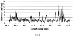
- FIG.4D shows the plot of corresponding estimated velocities of the dynamic obstacle in the world coordinate frame. It is identified that the velocity calculation is noisy for erroneous localization estimation of VINS-MONO technique.
- the restricted v-depth map produces multiple patches if there exist multiple obstacles on the same depth range ( FIG.5C ) and patches are segmented with similar image processing techniques as to the u-depth map.
- the height of bounding box ( v h ) in a restricted v-depth map ( FIG.5F ) is the corresponding height of the rectangle on the depth image.
- the top-left corner of the corresponding bounding box in the depth image is ( u l , v t ) where the width is u w and the height is v h .
- the dimensions are estimated ( FIG.5A and FIG.5C ) using the u-depth and the restricted v-depth maps.
- FIG.5C shows the restricted v-depth map that detects a small obstacle on the top and rectifies the height calculation.
- This two-dimensional rectangle of the depth image is transformed into the three-dimensional camera frame using the relation between the image plane and the camera coordinate frame c.
- f x , f y are the focal lengths in image horizontal and vertical direction respectively
- the one or more hardware processors 104 track the one or more obstacles by creating signatures for each obstacle and tracking the one or more obstacles by matching closeness among signatures in subsequent u-depth images.
- the obstacle tracking module 206 tracks the one or more detected obstacles associated in subsequential images. Usual methods to track is through associating visual features or using some probability function but we restricted to use any visual feature as these are computation heavy and tracking time grows with the size of an obstacle in the image frame. Here, limited number of pixels from the u-depth map is processed to track obstacles on subsequent frames.
- One popular way to match two image segments is through Hu-moments calculation where two images are compared with the associated structural properties.
- This method provides simple matching algorithm, that first creates a signature for the obstacle patch in the u-depth map and searches for a closer signature within a neighboring vicinity.
- Another advantage of using a u-depth map is if any obstacle moves parallel to the optical direction of the camera, the corresponding position change in the u-depth map is very minimal and tracking works well. Only if any obstacle moves left to right or vice versa, the change in the u-depth map would be at the same rate.
- an obstacle A consists of a set of points P A from the u-depth map.
- Another set of ordered points ⁇ A c C A were created such that points P i , P i +1 ⁇ ⁇ A ⁇ i should be connected with a vector l ⁇ i , i +1 and the vector should only pass through points from C A as shown in FIG.6 .
- the tuple ⁇ ⁇ A , ⁇ A , ⁇ A ⁇ creates the signature for the obstacle A where ⁇ A is the centroid.
- Cost A , B ⁇ i ⁇ ⁇ A , j ⁇ ⁇ B l ⁇ A i ⁇ l ⁇ B j + 1 ⁇ ⁇ l ⁇ A i ⁇ ⁇ ⁇ l ⁇ B j ⁇ 2
- l ⁇ A i ⁇ ⁇ A and l ⁇ B j ⁇ ⁇ B and i,j starts from the left-most points from ⁇ A and ⁇ B respectively.
- ⁇ calculates the angle between two vectors.
- ⁇ denotes the balancing factor between the two terms. It is considered matching if the Cost A,B is below from a threshold.
- the obstacles are tracked by comparing structural properties of obstacle appearance in the u-depth map by creating a signature of obstacle patch in the u-depth map, and iteratively for the one or more obstacles a closeness signature is searched within neighboring vicinity based on a shape alignment of each obstacle.
- the signature is the shape alignment of obstacle in a u-depth image which is formed with a set of vectors and a centroid, wherein the vectors are formed with pixels obtained from the contour of the obstacle in the u-depth map as illustrated with an example in FIG.6 , wherein the centroid is the average coordinate position of all pixels obtained from the contour of the obstacle in the u-depth map.
- the closeness signature is computed with the sum of differences derived between vectors of obstacle identified in the previous depth image and the vectors of obstacle identified in the next depth image starting from minimum column index.
- the one or more hardware processors 104 estimate the dynamic obstacles by converting the obstacles identified in the three-dimensional camera coordinates c into a world coordinate w and identifying dynamic obstacles based on velocity estimation is above to a predefined threshold value by using a dynamic obstacle estimation module.
- FIG.7 illustrates performance of obstacle being tracked in an outdoor environment using the system of FIG.1 , in accordance with some embodiments of the present disclosure.
- FIG.7 represents experimental results using a NVidia Jetson TX2 ® embedded computing board to implement the present method in C++ with ROS.
- the RealSense D435i ® transmits RGBD images of 848x480 @60 Hz, for online evaluation and Open LORIS Scene dataset for offline evaluation because with best of our knowledge, we do not find any benchmark RGBD dataset that contains ground truth positions of obstacle with time. It is to be noted that we are unable to produce any comparison with state-of-the-art approaches due to the unavailability of benchmark dataset. Localization and obstacle tracking uses RealSense D435i ® .
- the system 100 is capable of performing real-time with five obstacles or more with @60 Hz camera and dynamic obstacle tracking with maximum velocity of 2.5 m/sec with a @60 Hz camera.
- the present method of the disclosure is evaluated in Outdoor Sequences. It is tested with two persons walking with different velocities and directions. The velocity is of about 1 m/sec and obstacles are crossing with proximity. The method considers two obstacles as single obstacle when they are within proximity and two separate obstacles as they become farther apart.
- the first row of FIG.7 shows tracking results with estimated distances. The method evaluates dynamic obstacles that change its shape abruptly because this is very common in human motion.
- the 2nd row of FIG.7 shows the result of a sequence where a person first walks with normal speed, bend down suddenly for 4 seconds, again stands & starts walking.
- the third row in FIG.7 shows tracking results of fast-moving basketball with speed around 5 m/sec.
- the present method fails to detect the ball initially when it is far, but is successful in detecting/tracking from about 1.625 m away with partially visible and track until it goes out of field of view (FOV). All snapshots presents the relative distances between the camera to the ball and estimated velocities. The average estimated velocity is of about 7.114 m/sec.
- the embodiments of present disclosure herein addresses unresolved problem of obstacle detection and tracking.
- the embodiment thus provides method and system to detect and estimate dynamic obstacles using RGBD sensors for robot navigation.
- the embodiments herein further enable estimation of obstacles dimension accurately.
- the present disclosure adopts a fast three-dimensional obstacle detection approach to track dynamic obstacles with less computation and cost.
- the detection and tracking system runs on-board @60 Hz.
- the method achieves on average 0.6 ms per obstacle detection and tracking computation time and is successful to track obstacle with max speed 5 m/sec.
- the system estimates obstacles of any size and shape using light-weight tracking algorithm that makes tracking of obstacles faster, thus making the system suitable for a 60 Hz camera.
- Such computer-readable storage means contain program-code means for implementation of one or more steps of the method, when the program runs on a server or mobile device or any suitable programmable device.
- the hardware device can be any kind of device which can be programmed including e.g., any kind of computer like a server or a personal computer, or the like, or any combination thereof.
- the device may also include means which could be e.g., hardware means like e.g., an application-specific integrated circuit (ASIC), a field-programmable gate array (FPGA), or a combination of hardware and software means, e.g., an ASIC and an FPGA, or at least one microprocessor and at least one memory with software processing components located therein.
- the means can include both hardware means and software means.
- the method embodiments described herein could be implemented in hardware and software.
- the device may also include software means. Alternatively, the embodiments may be implemented on different hardware devices, e.g., using a plurality of CPUs.
- the embodiments herein can comprise hardware and software elements.
- the embodiments that are implemented in software include but are not limited to, firmware, resident software, microcode, etc.
- the functions performed by various components described herein may be implemented in other components or combinations of other components.
- a computer-usable or computer readable medium can be any apparatus that can comprise, store, communicate, propagate, or transport the program for use by or in connection with the instruction execution system, apparatus, or device.
- a computer-readable storage medium refers to any type of physical memory on which information or data readable by a processor may be stored.
- a computer-readable storage medium may store instructions for execution by one or more processors, including instructions for causing the processor(s) to perform steps or stages consistent with the embodiments described herein.
- the term "computer-readable medium” should be understood to include tangible items and exclude carrier waves and transient signals, i.e., be non-transitory. Examples include random access memory (RAM), read-only memory (ROM), volatile memory, nonvolatile memory, hard drives, CD ROMs, DVDs, flash drives, disks, and any other known physical storage media.
Landscapes
- Engineering & Computer Science (AREA)
- Robotics (AREA)
- Mechanical Engineering (AREA)
- Physics & Mathematics (AREA)
- General Physics & Mathematics (AREA)
- Multimedia (AREA)
- Theoretical Computer Science (AREA)
- Control Of Position, Course, Altitude, Or Attitude Of Moving Bodies (AREA)
- Image Analysis (AREA)
Abstract
Description
- The present application claims priority to
Indian application no. 202221013177, filed on March 10, 2022 - The disclosure herein generally relates to obstacle detection, and, more particularly, to method and system to detect and estimate dynamic obstacles using RGBD sensors for robot navigation.
- Service robots are envisioned to support humans in a variety of monitoring activities such as fetching and carrying objects. Therefore, robots are equipped with a sensor setup that allows close and safe interaction with obstacles while navigating through monitoring environments. Common to these application robot should be able to navigate in a cluttered 3D environment, to detect and recognize obstacles. Considerably, obstacle detection and tracking is an active research area for its applicability to autonomous driving or navigation. Obstacle detection is an important task for autonomous navigation of robots. Here, the task becomes more complex in dynamic and cluttered environments. In this context RGBD camera is one of the most common devices that provides a quick and good estimation of the environment in the form of RGB and depth images. Efficient processing of depth image is crucial for obstacle detection and tracking.
- Traditional approaches use both active and passive sensors for obstacle detection and tracking. Active sensors such as ultrasonic have been widely used for dynamic obstacle detection and passive sensors such as stereo cameras for distance calculation of obstacles through disparity measurement from image pairs have limitations within vision sensors. Autonomous ground vehicle provides intense focus on disparity processing, where u-disparity and v-disparity image formation from a stereo disparity explains properties for object identification after ground plane segmentation. This technique focuses on detecting obstacles that mainly stand on the ground plane like other vehicles, trees, pedestrians, and thereof. In low latency obstacle avoidance system uses u-disparity for fast obstacle detection in cluttered environments but dynamic obstacles are kept out of the scope. Further, low-cost RGBD camera (for example RealSense D400®) gains popularity due to technological advancement in terms of capabilities in indoor and outdoor, reduction in weight and form factor. These small, lightweight cameras are perfect to fit on Micro Aerial Vehicle (MAV) and focus on detecting obstacles from RGB-D cameras. In another conventional approach for dynamic obstacle segmentation a depth map is converted to a point cloud, the planer road is segmented out and all leftover points are considered as obstacles. This approach differentiates static and dynamic obstacles using the DECOLOR algorithm and demands high computations to process point cloud and unfit for MAV. In another conventional approach for obstacle detection and tracking system for teleoperated UAV that uses a bin occupancy filter that breaks the entire visible region into smaller bins and the presence of an obstacle into a bin is searched in a probabilistic way. While most of the existing approaches evolved to detect static obstacles, but have failed to satisfy requirements for detecting and tracking dynamic obstacles by processing depth images obtained from RGBD cameras.
- Embodiments of the present disclosure present technological improvements as solutions to one or more of the above-mentioned technical problems recognized by the inventors in conventional systems. For example, in one embodiment, a system to detect and estimate dynamic obstacles using RGBD sensors for robot navigation is provided. The system includes capturing one or more depth images using a depth camera module including a RGBD sensor configured to a mobile robot navigating through a monitoring environment and constructing a u-depth map using the one or more depth images. The obstacle detection module detects one or more obstacles comprising of atleast one of a static or a dynamic in two dimensional space using the u-depth map by, (i) converting, the u-depth map into binary images based on a dynamic threshold using an image processing technique, (ii) estimating, a width of each obstacle based on the width of segmented white patch from the u-depth map, and (iii) estimating, a depth range of each obstacle between a minimum and a maximum row index of the segmented white patch from the u-depth map. The obstacle detection module computes height of obstacle from a restricted v-depth map between specified columns taken from the width of each obstacle of the u-depth map and within the depth range derived from the u-depth map, and a height of each obstacle from the restricted v-depth map, and transform the height and width of one or more obstacles from the two dimensional image coordinates into a three-dimensional camera coordinates c. The obstacle tracking module creates signatures of each obstacle from their appearances in the u-depth map. The obstacle tracking module further tracks the one or more obstacles by matching closeness of signatures of detected obstacles on subsequent u-depth images. The dynamic obstacle estimation module estimates the dynamic obstacles by converting the obstacles identified in the three-dimensional camera coordinates c into a world coordinate w and identifying dynamic obstacles based on velocity estimation is above to a predefined threshold value. The velocities of dynamic obstacles are used to predict future positions of dynamic obstacles in the region of the monitoring environment.
- In accordance with an embodiment of the present disclosure, the restricted v-depth map estimates accurate height of each obstacle.
- In accordance with an embodiment of the present disclosure, the obstacles are tracked by comparing structural properties of obstacle appearance in the u-depth map by creating a signature of obstacle patch in the u-depth map, and iteratively for the one or more obstacles a closeness signature is searched within neighboring vicinity based on a shape alignment of each obstacle.
- In accordance with an embodiment of the present disclosure, the signature is the shape alignment of obstacle in a u-depth map which is formed with a set of vectors and a centroid. The vectors are formed with pixels that are taken from the contour of the obstacle in u-depth map. The centroid is the average coordinate position of all pixels that are taken from the contour of the obstacle in u-depth map.
- In accordance with an embodiment of the present disclosure, the closeness of signatures is computed with the sum of differences derived between vectors of obstacle's signature identified in the previous depth image and the vectors of obstacle's signature identified in the next depth image starting from minimum column index.
- In accordance with an embodiment of the present disclosure, difference between vectors is computed with a sum of angle difference and squared length difference.
- In another aspect, a method for detecting and estimating dynamic obstacles using RGBD sensors for robot navigation is provided. The method includes capturing one or more depth images using a depth camera module including a RGBD sensor configured to a mobile robot navigating through a monitoring environment and constructing a u-depth map using the one or more depth images. The obstacle detection module detects one or more obstacles comprising of atleast one of a static or a dynamic in two dimensional space using the u-depth map by, (i) converting, the u-depth map into binary images based on a dynamic threshold using an image processing technique, (ii) estimating, a width of each obstacle based on the width of segmented white patch from the u-depth map, and (iii) estimating, a depth range of each obstacle between a minimum and a maximum row index of the segmented white patch from the u-depth map. The obstacle detection module computes height of obstacle from a restricted v-depth map between specified columns taken from the width of each obstacle of the u-depth map and within the depth range derived from the u-depth map, a height of each obstacle from the restricted v-depth map, and transform the height and width of one or more obstacles from the two dimensional image coordinates into a three-dimensional camera coordinates c. The obstacle tracking module creates signatures of each obstacle from their appearances in the u-depth map. The obstacle tracking module further tracks the one or more obstacles by matching closeness of signatures of detected obstacles on subsequent u-depth images. The dynamic obstacle estimation module estimates the dynamic obstacles by converting the obstacles identified in the three-dimensional camera coordinates c into a world coordinate w and identifying dynamic obstacles based on velocity estimation is above to a predefined threshold value. The velocities of dynamic obstacles are used to predict future positions of dynamic obstacles in the region of the monitoring environment.
- In yet another aspect, a non-transitory computer readable medium provides one or more non-transitory machine-readable information storage mediums comprising one or more instructions, which when executed by one or more hardware processors perform actions includes an I/O interface and a memory coupled to the processor is capable of executing programmed instructions stored in the processor in the memory to capture one or more depth images using a depth camera module including a RGBD sensor configured to a mobile robot navigating through a monitoring environment and constructing a u-depth map using the one or more depth images. The obstacle detection module detects one or more obstacles comprising of atleast one of a static or a dynamic in two dimensional space using the u-depth map by, (i) converting, the u-depth map into binary images based on a dynamic threshold using an image processing technique, (ii) estimating, a width of each obstacle based on the width of segmented white patch from the u-depth map, and (iii) estimating, a depth range of each obstacle between a minimum and a maximum row index of the segmented white patch from the u-depth map. The obstacle detection module computes height of obstacle from a restricted v-depth map between specified columns taken from the width of each obstacle of the u-depth map and within the depth range derived from the u-depth map, a height of each obstacle from the restricted v-depth map, and transform the height and width of one or more obstacles from the two dimensional image coordinates into a three-dimensional camera coordinates c. The obstacle tracking module creates signatures of each obstacle from their appearances in the u-depth map. The obstacle tracking module further tracks the one or more obstacles by matching closeness of signatures of detected obstacles on subsequent u-depth images. The dynamic obstacle estimation module estimates the dynamic obstacles by converting the obstacles identified in the three-dimensional camera coordinates c into a world coordinate w and identifying dynamic obstacles based on velocity estimation is above to a predefined threshold value. The velocities of dynamic obstacles are used to predict future positions of dynamic obstacles in the region of the monitoring environment.
- It is to be understood that both the foregoing general description and the following detailed description are exemplary and explanatory only and are not restrictive of the invention, as claimed.
- The accompanying drawings, which are incorporated in and constitute a part of this disclosure, illustrate exemplary embodiments and, together with the description, serve to explain the disclosed principles:
-
FIG.1 illustrates an exemplary system 100 (alternatively referred as dynamic obstacle detection and tracking system), in accordance with some embodiments of the present disclosure. -
FIG. 2 is a functional block diagram of robust dynamic obstacle detection and tracking using RGBD cameras mounted on robot being navigating monitoring environment using the system ofFIG. 1 , in accordance with some embodiments of the present disclosure. -
FIG. 3A andFIG.3B illustrates an exemplary flow diagram illustrating a method to detect and track dynamic obstacles being identified in the monitoring environment using the system ofFIG.1 , in accordance with some embodiments of the present disclosure. -
FIG.4A illustrates an example RGBD camera image with static and dynamic obstacles and its annotations using the system ofFIG.1 , in accordance with some embodiments of the present disclosure. -
FIG.4B illustrates an example RVIZ image visualization of detected atleast one static obstacle and dynamic obstacle using the example ofFIG.4A in a form of three dimensional point cloud using the system ofFIG.1 , in accordance with some embodiments of the present disclosure. -
FIG.4C illustrates an experimental graph showing changes in relative distances between dynamic obstacle ofFIG.4A and the RGBD camera using the system ofFIG.1 , in accordance with some embodiments of the present disclosure. -
FIG.4D illustrates an experimental graph showing corresponding changes in velocities of the dynamic obstacles ofFIG.4A in world coordinate (w) using the system ofFIG.1 , in accordance with some embodiments of the present disclosure. -
FIG.5A through FIG.5D illustrate estimation of width and height of an obstacle in two dimensional image coordinate from a u-depth map and a restricted v-depth map respectively using the system ofFIG.1 , in accordance with some embodiments of the present disclosure. -
FIG.5E and FIG.5F illustrate the estimation of width and height of an obstacle in two dimensional image coordinate using the system ofFIG.1 , in accordance with some embodiments of the present disclosure. -
FIG.6 illustrates an example to the formation of vectors in the process of creating signature of an obstacle using the system ofFIG.1 , in accordance with some embodiments of the present disclosure. -
FIG.7 illustrates performance of dynamic obstacle being tracked in an outdoor environment using the system ofFIG.1 , in accordance with some embodiments of the present disclosure. - Exemplary embodiments are described with reference to the accompanying drawings. In the figures, the left-most digit(s) of a reference number identifies the figure in which the reference number first appears. Wherever convenient, the same reference numbers are used throughout the drawings to refer to the same or like parts. While examples and features of disclosed principles are described herein, modifications, adaptations, and other implementations are possible without departing from the scope of the disclosed embodiments.
- Embodiments herein provide a method and system to detect and track dynamic obstacles using RGBD sensors for robot navigation. The system herein may be alternatively referred as obstacle detection and
tracking system 100. Thesystem 100 includes a robot that comprises a RGBD sensor to obtain one or more depth images with an independent two-axis or three-axis degree of freedom to detect and track a target, e.g. a person or an obstacle or point of interest, with the RGBD camera independently of an actual flight direction or actual attitude of the robot. The method enables efficient processes of depth images for obstacle detection and tracking through the RGBD camera configured to the robot navigating in a monitoring environment. Thesystem 100 facilitates detection and quickly tracking and estimating of dynamic obstacles in subsequent frames of the monitoring environment for stable autonomous navigation. - Referring now to the drawings, and more particularly to
FIG. 1 through FIG.7 , where similar reference characters denote corresponding features consistently throughout the figures, there are shown preferred embodiments and these embodiments are described in the context of the following exemplary system and/or method. -
FIG.1 illustrates an exemplary system 100 (alternatively referred as dynamic obstacle detection and tracking system), in accordance with some embodiments of the present disclosure. In an embodiment, thesystem 100 includes one ormore hardware processors 104, communication interface device(s) or input/output (I/O) interface(s) 106 (also referred as interface(s)), and one or more data storage devices ormemory 102 operatively coupled to the one ormore hardware processors 104. The one ormore processors 104 may be one or more software processing components and/or hardware processors. In an embodiment, the hardware processors can be implemented as one or more microprocessors, microcomputers, microcontrollers, digital signal processors, central processing units, state machines, logic circuitries, and/or any devices that manipulate signals based on operational instructions. Among other capabilities, the processor(s) is/are configured to fetch and execute computer-readable instructions stored in the memory. In an embodiment, thesystem 100 can be implemented in a variety of computing systems, such as laptop computers, notebooks, hand-held devices, workstations, mainframe computers, servers, a network cloud, and the like. - The I/O interface device(s) 106 can include a variety of software and hardware interfaces, for example, a web interface, a graphical user interface, and the like and can facilitate multiple communications within a wide variety of networks N/W and protocol types, including wired networks, for example, LAN, cable, etc., and wireless networks, such as WLAN, cellular, or satellite. In an embodiment, the I/O interface device(s) can include one or more ports for connecting a number of devices to one another or to another server.
- The
memory 102 may include any computer-readable medium known in the art including, for example, volatile memory, such as static random-access memory (SRAM) and dynamic-random access memory (DRAM), and/or non-volatile memory, such as read only memory (ROM), erasable programmable ROM, flash memories, hard disks, optical disks, and magnetic tapes. Thememory 102 further comprises (or may further comprise) information pertaining to input(s)/output(s) of each step performed by the systems and methods of the present disclosure. In other words, input(s) fed at each step and output(s) generated at each step are comprised in thememory 102 and can be utilized in further processing and analysis. -
FIG. 2 is a functional block diagram of robust dynamic obstacle detection and tracking using RGBD cameras mounted on robot being navigating monitoring environment using the system ofFIG.1 , in accordance with some embodiments of the present disclosure.FIG. 2 includes a plurality of modules comprising adepth camera module 202, anobstacle detection module 204, anobstacle tracking module 206, a dynamicobstacle estimation module 208, and a visual inertial odometry module 210, - The
depth camera module 202 captures one or more depth images using a RGBD sensor configured to a mobile robot which navigates through a monitoring environment. - The
obstacle detection module 204 detects obstacle being identified in the monitoring environment using the depth images captured via the RGBD sensor. - The
obstacle tracking module 206 tracks the detected obstacles in subsequent images. - The dynamic
obstacle estimation module 208 identifies dynamic obstacles, estimates velocities of dynamic obstacles and predicts future positions within a predicted zone of the environment being monitored. The velocity estimation is computed in the world coordinate frame w. -
FIG. 3A andFIG.3B illustrates an exemplary flow diagram illustrating a method to detect and track dynamic obstacles being identified in the monitoring environment using the system ofFIG.1 , in accordance with some embodiments of the present disclosure. In an embodiment, the livevideo streaming system 100 comprises one or more data storage devices or thememory 102 operatively coupled to the processor(s) 104 and is configured to store instructions for execution of steps of themethod 300 by the processor(s) or one ormore hardware processors 104. The steps of themethod 300 of the present disclosure will now be explained with reference to the components or blocks of the livevideo streaming system 100 as depicted inFIG.2 through FIG.7 . Although process steps, method steps, techniques or the like may be described in a sequential order, such processes, methods and techniques may be configured to work in alternate orders. In other words, any sequence or order of steps that may be described does not necessarily indicate a requirement that the steps to be performed in that order. The steps of processes described herein may be performed in any order practical. Further, some steps may be performed simultaneously. - At
step 302 of themethod 300 the one ormore hardware processors 104 capture one or more depth images using a RGBD sensor configured to a mobile robot navigating through a monitoring environment and construct a u-depth map using the one or more depth images. Considering an example, illustrating RGBD camera image visualization where the RGBD sensor configured to the mobile robot obtains the one or more depth images (FIG.4A ) of the navigating region associated with the monitoring environment by using adepth camera module 202. Further, the u-depth map is constructed using the one or more depth images. - At
step 304 of themethod 300 the one ormore hardware processors 104 detect one or more obstacles comprising of atleast one of a static and a dynamic (e.g., static obstacle(s) or a dynamic obstacle(s)) in two-dimensional (2D) space using the u-depth map. The one or more depth images are processed to detect one or more obstacles being identified in the monitoring environment by using anobstacle detection module 204. Referring now toFIG.4B , where from the depth images captured via the RGBD camera detects atleast one static obstacle and dynamic obstacle in the point cloud. The constructed u-depth map is a column-wise histogram representation of depth values from each depth image. Considering an example depth image (DImg) whose width is W, height is H, a total number of bins is N and the sensor range is up to depth d. Range of each bin is d/N and the resolution of u-depth map is W ∗ N. The depth bins are on growing order from top to bottom in the u-depth map which means the row i corresponds to smaller depth than row j, ∀ i < j. The depth bin corresponding to the obstacles becomes high and visible as white horizontal patches. The dimension of white horizontal patch provides corresponding obstacle's position and size with the segment these white patches in the u-depth map. Initially, the u-depth map is converted into binary images based on a dynamic threshold using an image processing technique. - In one embodiment, one or more basic image processing operations are performed on the u-depth map to achieve stable segmentation The first operation is computing binary thresholding where threshold value is dynamic and is represented as Trow ∝ uDImgrow , means proportional with distance and provides more important to closer objects even with smaller size. The depth map is determined using a RealSense D435i® where the depth estimation is noisy and thus the u-depth map also contains some noise which makes these white patches discontinuous and very often a single obstacle can appear as two different obstacles. Further, a closing operation is performed on these white patches which essentially runs on a very small number of pixels and produces continuous patches quickly. Here, intensive morphological operations on the entire u-depth image are excluded for fast execution. The segment of these white horizontal patches are segmented by connected component analysis that provides a bounding box around the white horizontal patches as shown in
FIG.5A through FIG.5D . - In another embodiment, a width of each dynamic obstacle is estimated based on the width of segmented white patch from the u-depth map. Then, a depth range of each obstacle is estimated between a minimum and a maximum row index of the segmented white patch from the u-depth map.
- At
step 306 of themethod 300 the one ormore hardware processors 104 compute, a restricted v-depth map which is a row wise histogram of depth values from depth image obtained between specified columns taken from the width of each dynamic obstacle of the u-depth map and within the depth range derived from the u-depth map by using anobstacle detection module 204. Theobstacle detection module 204 estimates a height of each obstacle from the restricted v-depth map, and transforms the height and width of one or more obstacles from the two dimensional image coordinates into a three-dimensional camera coordinates c. After detecting the one or more obstacles and estimating their two dimensional sizes in depth image, three dimensional parallelepiped shape of the one or more obstacles are determined with three dimensions size represented as (cdimh ,cdimw ,cdimd ) and three dimensional position (cPx ,cPy ,cPz ), where c denotes the camera coordinate frame. Referring toFIG.4A andFIG.5A which illustrates the example RGBD camera image with obstacles and its annotations to compute the dimensions of the bounding box around an obstacle on the depth map using the dimensions of the segmented white patch on the corresponding u-depth map. Consider the bounding box (FIG.5E ) with width uw. The width of the corresponding rectangle on the u-depth map is the same as uw because the u-depth map contains a column-wise histogram, therefore the width remains the same. The height of the corresponding rectangle is the minimum and maximum row wise pixels that are having depth within the depth range dmin and dmax values are obtained. Further, the dmin and dmax values from the corresponding depth bin of ut and (ut + uh ) respectively. Existing methods in the literature estimate height of an obstacle on depth image using the above mentioned technique, but this estimation holds true only if there is only one obstacle within column ul and (ul + uw ) and the depth range between dmax to dmin . - In one embodiment,
FIG.5A and FIG.5C illustrates one such wrong height estimation of obstacle (with a tall bounding box) by calculating height from the top most and bottom most coordinates points present on the depth images within column ranges ul and (ul + uw ) and within the depth ranges dmax to dmin which is known in the state of the art. The wrong height estimation occurs when multiple obstacles present within the above mentioned column ranges and depth ranges. State of the art methods estimate a combined height of all obstacles present within the above mentioned column ranges and depth ranges.FIG.5C represents the restricted v-depth map that found another small obstacle on the top which is illustrated in a magnified view inFIG.5D . - In one embodiment, the present method of the disclosure is evaluated for the indoor open sequences analysis shows market sequence of Open LORIS-Scene dataset. The dataset environment is a real-world departmental shop in indoor lighting conditions with multiple dynamic and static obstacles. The RGBD image is of 848x480 @30 Hz.
FIG.4A shows one such snapshot where the system tracks dynamic obstacle and calculates its velocity.FIG.4B shows a RVIZ snapshot where dynamic obstacle is represented as parallelepiped and shows the dimensions.FIG.4C shows the plot of relative distances of dynamic obstacle from the camera andFIG.4D shows the plot of corresponding estimated velocities of the dynamic obstacle in the world coordinate frame. It is identified that the velocity calculation is noisy for erroneous localization estimation of VINS-MONO technique. - The restricted v-depth map produces multiple patches if there exist multiple obstacles on the same depth range (
FIG.5C ) and patches are segmented with similar image processing techniques as to the u-depth map. The height of bounding box (vh ) in a restricted v-depth map (FIG.5F ) is the corresponding height of the rectangle on the depth image. The top-left corner of the corresponding bounding box in the depth image is (ul , vt ) where the width is uw and the height is vh. The dimensions are estimated (FIG.5A and FIG.5C ) using the u-depth and the restricted v-depth maps.FIG.5C shows the restricted v-depth map that detects a small obstacle on the top and rectifies the height calculation. This two-dimensional rectangle of the depth image is transformed into the three-dimensional camera frame using the relation between the image plane and the camera coordinate frame c.Equation 1 shows the relations to calculate these dimensions,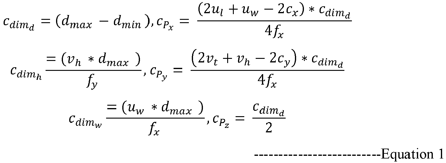
- At
step 308 of themethod 300 the one ormore hardware processors 104 track the one or more obstacles by creating signatures for each obstacle and tracking the one or more obstacles by matching closeness among signatures in subsequent u-depth images. Theobstacle tracking module 206 tracks the one or more detected obstacles associated in subsequential images. Usual methods to track is through associating visual features or using some probability function but we restricted to use any visual feature as these are computation heavy and tracking time grows with the size of an obstacle in the image frame. Here, limited number of pixels from the u-depth map is processed to track obstacles on subsequent frames. One popular way to match two image segments is through Hu-moments calculation where two images are compared with the associated structural properties. But the horizontal white patches do not contain such good structural properties and therefore, thus Hu-moments matching produces many false-positive results. This method provides simple matching algorithm, that first creates a signature for the obstacle patch in the u-depth map and searches for a closer signature within a neighboring vicinity. Another advantage of using a u-depth map is if any obstacle moves parallel to the optical direction of the camera, the corresponding position change in the u-depth map is very minimal and tracking works well. Only if any obstacle moves left to right or vice versa, the change in the u-depth map would be at the same rate. - In one embodiment, it is assumed that an obstacle A consists of a set of points PA from the u-depth map. There is another set of points CA ⊂ PA that represents the contour of A. Now another set of ordered points ΦA c CA were created such that points Pi , P i+1 ∈ Φ A ∀ i should be connected with a vector l̂ i,i+1 and the vector should only pass through points from CA as shown in
FIG.6 . These all vectors create a set Ω A and ∥ Φ A ∥=∥ Ω A ∥. The tuple {


Equation 2 between signatures of A and transformed B.
i ∈ Ω A and l̂ Bj ∈ Ω B and i,j starts from the left-most points from Φ A and Φ B respectively. ⊙ calculates the angle between two vectors. ∂ denotes the balancing factor between the two terms. It is considered matching if the CostA,B is below from a threshold. Once the signature matches, update the signature with the latest one. This simplistic approach makes stable tracking with a minimal time. - The obstacles are tracked by comparing structural properties of obstacle appearance in the u-depth map by creating a signature of obstacle patch in the u-depth map, and iteratively for the one or more obstacles a closeness signature is searched within neighboring vicinity based on a shape alignment of each obstacle.
- The signature is the shape alignment of obstacle in a u-depth image which is formed with a set of vectors and a centroid, wherein the vectors are formed with pixels obtained from the contour of the obstacle in the u-depth map as illustrated with an example in
FIG.6 , wherein the centroid is the average coordinate position of all pixels obtained from the contour of the obstacle in the u-depth map. - The closeness signature is computed with the sum of differences derived between vectors of obstacle identified in the previous depth image and the vectors of obstacle identified in the next depth image starting from minimum column index.
- At
step 310 of themethod 300 the one ormore hardware processors 104 estimate the dynamic obstacles by converting the obstacles identified in the three-dimensional camera coordinates c into a world coordinate w and identifying dynamic obstacles based on velocity estimation is above to a predefined threshold value by using a dynamic obstacle estimation module. -
FIG.7 illustrates performance of obstacle being tracked in an outdoor environment using the system ofFIG.1 , in accordance with some embodiments of the present disclosure.FIG.7 represents experimental results using a NVidia Jetson TX2® embedded computing board to implement the present method in C++ with ROS. The RealSense D435i®, transmits RGBD images of 848x480 @60 Hz, for online evaluation and Open LORIS Scene dataset for offline evaluation because with best of our knowledge, we do not find any benchmark RGBD dataset that contains ground truth positions of obstacle with time. It is to be noted that we are unable to produce any comparison with state-of-the-art approaches due to the unavailability of benchmark dataset. Localization and obstacle tracking uses RealSense D435i®. Experimental results showsobstacle detection module 204 andtracking module 206 jointly take 0.4 to 0.9 milliseconds for single obstacle irrespective of its size on the image frame and the average tracking time is about 4 to 5 ms for the entire image considering 5 obstacles. Therefore, thesystem 100 is capable of performing real-time with five obstacles or more with @60 Hz camera and dynamic obstacle tracking with maximum velocity of 2.5 m/sec with a @60 Hz camera. - In one embodiment, the present method of the disclosure is evaluated in Outdoor Sequences. It is tested with two persons walking with different velocities and directions. The velocity is of about 1 m/sec and obstacles are crossing with proximity. The method considers two obstacles as single obstacle when they are within proximity and two separate obstacles as they become farther apart. The first row of
FIG.7 shows tracking results with estimated distances. The method evaluates dynamic obstacles that change its shape abruptly because this is very common in human motion. The 2nd row ofFIG.7 shows the result of a sequence where a person first walks with normal speed, bend down suddenly for 4 seconds, again stands & starts walking. The third row inFIG.7 shows tracking results of fast-moving basketball with speed around 5 m/sec. The present method fails to detect the ball initially when it is far, but is successful in detecting/tracking from about 1.625 m away with partially visible and track until it goes out of field of view (FOV). All snapshots presents the relative distances between the camera to the ball and estimated velocities. The average estimated velocity is of about 7.114 m/sec. - The written description describes the subject matter herein to enable any person skilled in the art to make and use the embodiments. The scope of the subject matter embodiments is defined by the claims and may include other modifications that occur to those skilled in the art. Such other modifications are intended to be within the scope of the claims if they have similar elements that do not differ from the literal language of the claims or if they include equivalent elements with insubstantial differences from the literal language of the claims.
- The embodiments of present disclosure herein addresses unresolved problem of obstacle detection and tracking. The embodiment, thus provides method and system to detect and estimate dynamic obstacles using RGBD sensors for robot navigation. Moreover, the embodiments herein further enable estimation of obstacles dimension accurately. The present disclosure adopts a fast three-dimensional obstacle detection approach to track dynamic obstacles with less computation and cost. The detection and tracking system runs on-board @60 Hz. The method achieves on average 0.6 ms per obstacle detection and tracking computation time and is successful to track obstacle with max speed 5 m/sec. Also, the system estimates obstacles of any size and shape using light-weight tracking algorithm that makes tracking of obstacles faster, thus making the system suitable for a 60 Hz camera.
- It is to be understood that the scope of the protection is extended to such a program and in addition to a computer-readable means having a message therein; such computer-readable storage means contain program-code means for implementation of one or more steps of the method, when the program runs on a server or mobile device or any suitable programmable device. The hardware device can be any kind of device which can be programmed including e.g., any kind of computer like a server or a personal computer, or the like, or any combination thereof. The device may also include means which could be e.g., hardware means like e.g., an application-specific integrated circuit (ASIC), a field-programmable gate array (FPGA), or a combination of hardware and software means, e.g., an ASIC and an FPGA, or at least one microprocessor and at least one memory with software processing components located therein. Thus, the means can include both hardware means and software means. The method embodiments described herein could be implemented in hardware and software. The device may also include software means. Alternatively, the embodiments may be implemented on different hardware devices, e.g., using a plurality of CPUs.
- The embodiments herein can comprise hardware and software elements. The embodiments that are implemented in software include but are not limited to, firmware, resident software, microcode, etc. The functions performed by various components described herein may be implemented in other components or combinations of other components. For the purposes of this description, a computer-usable or computer readable medium can be any apparatus that can comprise, store, communicate, propagate, or transport the program for use by or in connection with the instruction execution system, apparatus, or device.
- The illustrated steps are set out to explain the exemplary embodiments shown, and it should be anticipated that ongoing technological development will change the manner in which particular functions are performed. These examples are presented herein for purposes of illustration, and not limitation. Further, the boundaries of the functional building blocks have been arbitrarily defined herein for the convenience of the description. Alternative boundaries can be defined so long as the specified functions and relationships thereof are appropriately performed. Alternatives (including equivalents, extensions, variations, deviations, etc., of those described herein) will be apparent to persons skilled in the relevant art(s) based on the teachings contained herein. Such alternatives fall within the scope of the disclosed embodiments. Also, the words "comprising," "having," "containing," and "including," and other similar forms are intended to be equivalent in meaning and be open ended in that an item or items following any one of these words is not meant to be an exhaustive listing of such item or items, or meant to be limited to only the listed item or items. It must also be noted that as used herein and in the appended claims, the singular forms "a," "an," and "the" include plural references unless the context clearly dictates otherwise.
- Furthermore, one or more computer-readable storage media may be utilized in implementing embodiments consistent with the present disclosure. A computer-readable storage medium refers to any type of physical memory on which information or data readable by a processor may be stored. Thus, a computer-readable storage medium may store instructions for execution by one or more processors, including instructions for causing the processor(s) to perform steps or stages consistent with the embodiments described herein. The term "computer-readable medium" should be understood to include tangible items and exclude carrier waves and transient signals, i.e., be non-transitory. Examples include random access memory (RAM), read-only memory (ROM), volatile memory, nonvolatile memory, hard drives, CD ROMs, DVDs, flash drives, disks, and any other known physical storage media.
- It is intended that the disclosure and examples be considered as exemplary only, with a true scope of disclosed embodiments being indicated by the following claims.
Claims (15)
- A processor implemented method (104) to detect and estimate dynamic obstacles using RGBD sensors for robot navigation, the method comprising:capturing (302), one or more depth images using a RGBD sensor configured to a mobile robot navigating through a monitoring environment and constructing a u-depth map using the one or more depth images;detecting (304), one or more obstacles comprising of atleast one of a static or a dynamic in two dimensional space using the u-depth map by, (i) converting, the u-depth map into binary images based on a dynamic threshold using an image processing technique, (ii) estimating, a width of each obstacle based on the width of segmented white patch from the u-depth map, and (iii) estimating, a depth range of each obstacle between a minimum and a maximum row index of the segmented white patch from the u-depth map;compute (306), a restricted v-depth map between specified columns taken from the width of each dynamic obstacle of the u-depth map and within the depth range derived from the u-depth map, a height of each obstacle from the restricted v-depth map and, transform the height and width of one or more obstacles from the two dimensional image coordinates into a three-dimensional camera coordinates c;tracking (308), by creating signatures for each obstacle and tracking the one or more obstacles by matching closeness among signatures in subsequent u-depth images; andestimating (310), the dynamic obstacles by converting the obstacles identified in the three-dimensional camera coordinates c into a world coordinate w and identifying dynamic obstacles based on velocity estimation is above to a predefined threshold value.
- The processor (104) implemented method as claimed in claim 1, wherein the restricted v-depth map estimates accurate height of each obstacle, wherein the obstacles are tracked by comparing structural properties of obstacle appearance in the u-depth map by creating a signature of obstacle patch in the u-depth map, and iteratively for the one or more obstacles a closeness signature is searched within neighboring vicinity based on a shape alignment of each obstacle.
- The processor (104) implemented method as claimed in claim 1, wherein the signature is the shape alignment of obstacle in a depth image which is formed with a set of vectors and a centroid, wherein the vectors are formed with pixels obtained from the contour of each obstacle in the u-depth map, wherein the centroid is the average coordinate position of all pixels obtained from the contour of the obstacle in the u-depth map.
- The processor (104) implemented method as claimed in claim 1, wherein the closeness signature is computed with the sum of differences derived between vectors of obstacle's signature identified in the previous depth image and the vectors of obstacle's signature identified in the next depth image starting from minimum column index.
- The processor (104) implemented method as claimed in claim 1, wherein the difference between vectors is computed with a sum of angle difference and squared length difference.
- A system (100) to detect and estimate dynamic obstacles using RGBD sensors for robot navigation, comprising:a memory (102) storing instructions;one or more communication interfaces (106); andone or more hardware processors (104) coupled to the memory (102) via the one or more communication interfaces (106), wherein the one or more hardware processors (104) are configured by the instructions to:capture one or more depth images using a RGBD sensor configured to a mobile robot navigating through a monitoring environment and constructing a u-depth map using the one or more depth images;detect, one or more obstacles comprising of atleast one of a static or a dynamic in two dimensional space using the u-depth map by, (i) converting, the u-depth map into binary images based on a dynamic threshold using an image processing technique, (ii) estimating, a width of each obstacle based on the width of segmented white patch from the u-depth map, and (iii) estimating, a depth range of each obstacle between a minimum and a maximum row index of the segmented white patch from the u-depth map;compute, a restricted v-depth map between specified columns taken from the width of each dynamic obstacle of the u-depth map and within the depth range derived from the u-depth map, and a height of each obstacle from the restricted v-depth map, and transform the height and width of one or more obstacles from the two dimensional image coordinates into a three-dimensional camera coordinates c;track, the one or more obstacles by creating signatures for each obstacle and tracking the one or more obstacles by matching closeness among signatures in subsequent u-depth images; andestimate, the dynamic obstacles by converting the obstacles identified in the three-dimensional camera coordinates c into a world coordinate w and identifying dynamic obstacles based on velocity estimation is above to a predefined threshold value.
- The system (100) of claim 6, wherein the restricted v-depth map estimates accurate height of each obstacle, wherein the obstacles are tracked by comparing structural properties of obstacle appearance in the u-depth map by creating a signature of obstacle patch in the u-depth map, and iteratively for the one or more obstacles a closeness signature is searched within neighboring vicinity based on a shape alignment of each obstacle.
- The system (100) of claim 6, wherein the signature is the shape alignment of obstacle in a next depth image which is formed with a set of vectors and a centroid, wherein the vectors are formed with pixels obtained from the contour of the obstacle in the u-depth map, wherein the centroid is the average coordinate position of all pixels obtained from the contour of the obstacle in the u-depth map.
- The system (100) of claim 6, wherein the closeness signature is computed with the sum of differences derived between vectors of obstacle's signature identified in the previous depth image and the vectors of obstacle's signature identified in the next depth image starting from minimum column index.
- The system (100) of claim 6, wherein the difference between vectors is computed with a sum of angle difference and squared length difference.
- One or more non-transitory machine-readable information storage mediums comprising one or more instructions which when executed by one or more hardware processors cause:capturing, one or more depth images using a RGBD sensor configured to a mobile robot navigating through a monitoring environment and constructing a u-depth map using the one or more depth images;detecting, one or more obstacles comprising of atleast one of a static or a dynamic in two dimensional space using the u-depth map by, (i) converting, the u-depth map into binary images based on a dynamic threshold using an image processing technique, (ii) estimating, a width of each obstacle based on the width of segmented white patch from the u-depth map, and (iii) estimating, a depth range of each obstacle between a minimum and a maximum row index of the segmented white patch from the u-depth map;computing, a restricted v-depth map between specified columns taken from the width of each dynamic obstacle of the u-depth map and within the depth range derived from the u-depth map, a height of each obstacle from the restricted v-depth map and, transforming the height and width of one or more obstacles from the two dimensional image coordinates into a three-dimensional camera coordinates c;tracking, by creating signatures for each obstacle and tracking the one or more obstacles by matching closeness among signatures in subsequent u-depth images; andestimating, the dynamic obstacles by converting the obstacles identified in the three-dimensional camera coordinates c into a world coordinate w and identifying dynamic obstacles based on velocity estimation is above to a predefined threshold value.
- The one or more non-transitory machine-readable information storage mediums of claim 11, wherein the restricted v-depth map estimates accurate height of each obstacle, wherein the obstacles are tracked by comparing structural properties of obstacle appearance in the u-depth map by creating a signature of obstacle patch in the u-depth map, and iteratively for the one or more obstacles a closeness signature is searched within neighboring vicinity based on a shape alignment of each obstacle.
- The one or more non-transitory machine-readable information storage mediums of claim 11, wherein the signature is the shape alignment of obstacle in a depth image which is formed with a set of vectors and a centroid, wherein the vectors are formed with pixels obtained from the contour of each obstacle in the u-depth map, wherein the centroid is the average coordinate position of all pixels obtained from the contour of the obstacle in the u-depth map.
- The one or more non-transitory machine-readable information storage mediums of claim 11, wherein the closeness signature is computed with the sum of differences derived between vectors of obstacle's signature identified in the previous depth image and the vectors of obstacle's signature identified in the next depth image starting from minimum column index.
- The one or more non-transitory machine-readable information storage mediums of claim 11, wherein the difference between vectors is computed with a sum of angle difference and squared length difference.
Applications Claiming Priority (1)
| Application Number | Priority Date | Filing Date | Title |
|---|---|---|---|
| IN202221013177 | 2022-03-10 |
Publications (1)
| Publication Number | Publication Date |
|---|---|
| EP4242986A1 true EP4242986A1 (en) | 2023-09-13 |
Family
ID=84360933
Family Applications (1)
| Application Number | Title | Priority Date | Filing Date |
|---|---|---|---|
| EP22208864.3A Withdrawn EP4242986A1 (en) | 2022-03-10 | 2022-11-22 | Method and system to detect and estimate dynamic obstacles using rgbd sensors for robot navigation |
Country Status (2)
| Country | Link |
|---|---|
| US (1) | US12296488B2 (en) |
| EP (1) | EP4242986A1 (en) |
Citations (3)
| Publication number | Priority date | Publication date | Assignee | Title |
|---|---|---|---|---|
| US20120253582A1 (en) * | 2011-03-30 | 2012-10-04 | Microsoft Corporation | Semi-Autonomous Mobile Device Driving with Obstacle Avoidance |
| US20200209880A1 (en) * | 2018-12-28 | 2020-07-02 | Ubtech Robotics Corp Ltd | Obstacle detection method and apparatus and robot using the same |
| CN113822260A (en) * | 2021-11-24 | 2021-12-21 | 杭州蓝芯科技有限公司 | Depth image-based obstacle detection method and device, electronic device, and medium |
Family Cites Families (23)
| Publication number | Priority date | Publication date | Assignee | Title |
|---|---|---|---|---|
| US7974460B2 (en) | 2007-02-06 | 2011-07-05 | Honeywell International Inc. | Method and system for three-dimensional obstacle mapping for navigation of autonomous vehicles |
| US9338409B2 (en) * | 2012-01-17 | 2016-05-10 | Avigilon Fortress Corporation | System and method for home health care monitoring |
| EP3391339A2 (en) * | 2015-12-18 | 2018-10-24 | Iris Automation, Inc. | Real-time visual situational awareness system |
| US11461912B2 (en) * | 2016-01-05 | 2022-10-04 | California Institute Of Technology | Gaussian mixture models for temporal depth fusion |
| US20170216728A1 (en) * | 2016-01-29 | 2017-08-03 | Twin Harbor Labs Llc | Augmented reality incorporating physical objects |
| US10282902B1 (en) * | 2016-06-24 | 2019-05-07 | Amazon Technologies, Inc. | Real-time textured 3D models |
| EP4131172A1 (en) | 2016-09-12 | 2023-02-08 | Dassault Systèmes | Deep convolutional neural network for 3d reconstruction of a real object |
| KR102714691B1 (en) * | 2016-12-06 | 2024-10-10 | (주)엠아이웨어 | Object Detection method of Moving Vehicle using Depth-Map of Camera Image |
| US11676296B2 (en) * | 2017-08-11 | 2023-06-13 | Sri International | Augmenting reality using semantic segmentation |
| KR102472767B1 (en) * | 2017-09-14 | 2022-12-01 | 삼성전자주식회사 | Method and apparatus of calculating depth map based on reliability |
| US10672188B2 (en) * | 2018-04-19 | 2020-06-02 | Microsoft Technology Licensing, Llc | Surface reconstruction for environments with moving objects |
| CN111238465B (en) * | 2018-11-28 | 2022-02-18 | 台达电子工业股份有限公司 | Map building equipment and map building method thereof |
| US10937325B2 (en) | 2018-12-27 | 2021-03-02 | Intel Corporation | Collision avoidance system, depth imaging system, vehicle, obstacle map generator, and methods thereof |
| CN111382637B (en) * | 2018-12-29 | 2023-08-08 | 深圳市优必选科技有限公司 | Pedestrian detection tracking method, device, terminal equipment and medium |
| US11288842B2 (en) * | 2019-02-15 | 2022-03-29 | Interaptix Inc. | Method and system for re-projecting and combining sensor data for visualization |
| US10885710B2 (en) * | 2019-03-14 | 2021-01-05 | Microsoft Technology Licensing, Llc | Reality-guided roaming in virtual reality |
| WO2020223636A1 (en) * | 2019-05-01 | 2020-11-05 | Magic Leap, Inc. | Content provisioning system and method |
| CN110135331A (en) * | 2019-05-13 | 2019-08-16 | 人加智能机器人技术(北京)有限公司 | Interbehavior detection method, device, system, equipment and storage medium |
| JP7490471B2 (en) * | 2020-07-01 | 2024-05-27 | キヤノン株式会社 | Image processing device and method |
| JP7389729B2 (en) * | 2020-09-10 | 2023-11-30 | 株式会社日立製作所 | Obstacle detection device, obstacle detection system and obstacle detection method |
| US12399501B2 (en) * | 2020-12-10 | 2025-08-26 | AI Incorporated | Method of lightweight simultaneous localization and mapping performed on a real-time computing and battery operated wheeled device |
| CN113607161B (en) * | 2021-09-30 | 2022-03-18 | 深圳市普渡科技有限公司 | Robot navigation path width acquisition system, method, robot and storage medium |
| US20230195854A1 (en) * | 2021-12-22 | 2023-06-22 | Julien Ip | Filtering of dynamic objects from vehicle generated map |
-
2022
- 2022-11-22 EP EP22208864.3A patent/EP4242986A1/en not_active Withdrawn
- 2022-11-28 US US18/059,133 patent/US12296488B2/en active Active
Patent Citations (3)
| Publication number | Priority date | Publication date | Assignee | Title |
|---|---|---|---|---|
| US20120253582A1 (en) * | 2011-03-30 | 2012-10-04 | Microsoft Corporation | Semi-Autonomous Mobile Device Driving with Obstacle Avoidance |
| US20200209880A1 (en) * | 2018-12-28 | 2020-07-02 | Ubtech Robotics Corp Ltd | Obstacle detection method and apparatus and robot using the same |
| CN113822260A (en) * | 2021-11-24 | 2021-12-21 | 杭州蓝芯科技有限公司 | Depth image-based obstacle detection method and device, electronic device, and medium |
Non-Patent Citations (1)
| Title |
|---|
| LIN JIAHAO ET AL: "Robust Vision-based Obstacle Avoidance for Micro Aerial Vehicles in Dynamic Environments", 2020 IEEE INTERNATIONAL CONFERENCE ON ROBOTICS AND AUTOMATION (ICRA), IEEE, 31 May 2020 (2020-05-31), pages 2682 - 2688, XP033826822, DOI: 10.1109/ICRA40945.2020.9197481 * |
Also Published As
| Publication number | Publication date |
|---|---|
| US20230286155A1 (en) | 2023-09-14 |
| US12296488B2 (en) | 2025-05-13 |
Similar Documents
| Publication | Publication Date | Title |
|---|---|---|
| Huang et al. | ClusterVO: Clustering moving instances and estimating visual odometry for self and surroundings | |
| US10438371B2 (en) | Three-dimensional bounding box from two-dimensional image and point cloud data | |
| KR102347015B1 (en) | Vehicle tracking in a warehouse environment | |
| US9933264B2 (en) | System and method for achieving fast and reliable time-to-contact estimation using vision and range sensor data for autonomous navigation | |
| WO2020048285A1 (en) | Estimating two-dimensional object bounding box information based on bird's-eye view point cloud | |
| KR101725060B1 (en) | Apparatus for recognizing location mobile robot using key point based on gradient and method thereof | |
| EP3414641B1 (en) | System and method for achieving fast and reliable time-to-contact estimation using vision and range sensor data for autonomous navigation | |
| EP2166375B1 (en) | System and method of extracting plane features | |
| US11430199B2 (en) | Feature recognition assisted super-resolution method | |
| Saha et al. | 3D LiDAR-based obstacle detection and tracking for autonomous navigation in dynamic environments: A. Saha, BC Dhara | |
| EP2610783B1 (en) | Object recognition method using an object descriptor | |
| Guizilini et al. | Semi-parametric models for visual odometry | |
| EP4502950A1 (en) | Visual localization method and related apparatus | |
| CN114326695B (en) | Self-propelled vehicle following system and self-propelled vehicle following method | |
| WO2024239605A1 (en) | Attack detection method and apparatus for autonomous driving system, device, and storage medium | |
| Dang et al. | Moving objects elimination towards enhanced dynamic SLAM fusing LiDAR and mmW-radar | |
| EP4242986A1 (en) | Method and system to detect and estimate dynamic obstacles using rgbd sensors for robot navigation | |
| Das et al. | Taming the north: Multi-camera parallel tracking and mapping in snow-laden environments | |
| CN115752489B (en) | Positioning method and device of movable equipment and electronic equipment | |
| Li et al. | TTC4MCP: Monocular Collision Prediction Based on Self-Supervised TTC Estimation | |
| Chakraborty et al. | Novel stereo visual odometry pipeline for autonomous robot navigation on video data | |
| Chen et al. | ATopNet: Robust visual localization for AMR navigation | |
| US20250370466A1 (en) | Monocular obstacle detection on a drone flight path | |
| CN119027638B (en) | Marine visual SLAM ranging method, device, computer equipment and storage medium | |
| Molchanov et al. | A real-time system for detection and avoidance of dynamic obstacles for micro UAVs |
Legal Events
| Date | Code | Title | Description |
|---|---|---|---|
| PUAI | Public reference made under article 153(3) epc to a published international application that has entered the european phase |
Free format text: ORIGINAL CODE: 0009012 |
|
| STAA | Information on the status of an ep patent application or granted ep patent |
Free format text: STATUS: THE APPLICATION HAS BEEN PUBLISHED |
|
| AK | Designated contracting states |
Kind code of ref document: A1 Designated state(s): AL AT BE BG CH CY CZ DE DK EE ES FI FR GB GR HR HU IE IS IT LI LT LU LV MC ME MK MT NL NO PL PT RO RS SE SI SK SM TR |
|
| STAA | Information on the status of an ep patent application or granted ep patent |
Free format text: STATUS: REQUEST FOR EXAMINATION WAS MADE |
|
| 17P | Request for examination filed |
Effective date: 20231002 |
|
| RBV | Designated contracting states (corrected) |
Designated state(s): AL AT BE BG CH CY CZ DE DK EE ES FI FR GB GR HR HU IE IS IT LI LT LU LV MC ME MK MT NL NO PL PT RO RS SE SI SK SM TR |
|
| STAA | Information on the status of an ep patent application or granted ep patent |
Free format text: STATUS: EXAMINATION IS IN PROGRESS |
|
| 17Q | First examination report despatched |
Effective date: 20231122 |
|
| STAA | Information on the status of an ep patent application or granted ep patent |
Free format text: STATUS: THE APPLICATION HAS BEEN WITHDRAWN |
|
| 18W | Application withdrawn |
Effective date: 20250623 |