CN115620179A - Unmanned aerial vehicle-based fire detection method and device, electronic equipment and medium - Google Patents
Unmanned aerial vehicle-based fire detection method and device, electronic equipment and medium Download PDFInfo
- Publication number
- CN115620179A CN115620179A CN202211273444.3A CN202211273444A CN115620179A CN 115620179 A CN115620179 A CN 115620179A CN 202211273444 A CN202211273444 A CN 202211273444A CN 115620179 A CN115620179 A CN 115620179A
- Authority
- CN
- China
- Prior art keywords
- target
- fire
- image data
- patrol area
- target patrol
- Prior art date
- Legal status (The legal status is an assumption and is not a legal conclusion. Google has not performed a legal analysis and makes no representation as to the accuracy of the status listed.)
- Pending
Links
Images


Classifications
-
- G—PHYSICS
- G06—COMPUTING OR CALCULATING; COUNTING
- G06V—IMAGE OR VIDEO RECOGNITION OR UNDERSTANDING
- G06V20/00—Scenes; Scene-specific elements
- G06V20/10—Terrestrial scenes
- G06V20/17—Terrestrial scenes taken from planes or by drones
-
- G—PHYSICS
- G05—CONTROLLING; REGULATING
- G05D—SYSTEMS FOR CONTROLLING OR REGULATING NON-ELECTRIC VARIABLES
- G05D1/00—Control of position, course, altitude or attitude of land, water, air or space vehicles, e.g. using automatic pilots
- G05D1/10—Simultaneous control of position or course in three dimensions
- G05D1/101—Simultaneous control of position or course in three dimensions specially adapted for aircraft
-
- G—PHYSICS
- G06—COMPUTING OR CALCULATING; COUNTING
- G06V—IMAGE OR VIDEO RECOGNITION OR UNDERSTANDING
- G06V10/00—Arrangements for image or video recognition or understanding
- G06V10/40—Extraction of image or video features
Landscapes
- Engineering & Computer Science (AREA)
- Physics & Mathematics (AREA)
- General Physics & Mathematics (AREA)
- Remote Sensing (AREA)
- Multimedia (AREA)
- Theoretical Computer Science (AREA)
- Aviation & Aerospace Engineering (AREA)
- Radar, Positioning & Navigation (AREA)
- Automation & Control Theory (AREA)
- Alarm Systems (AREA)
Abstract
本发明实施方式提供一种基于无人机的火情检测方法及装置、电子设备及介质。基于无人机的火情检测方法包括:接收巡逻无人机发送的第一影像数据;对第一影像数据进行图像检测,判断目标巡逻区域中是否发生火情;若确定目标巡逻区域发生火情,则获取目标巡逻区域的坐标信息;根据目标巡逻区域的坐标信息,在目标巡逻区域对应的数字地图上进行标记,以派送监测无人机对目标巡逻区域进行火情确认。通过本发明,通过对巡逻无人机采集的影像数据进行图像检测,确定目标巡逻区域是否发生火情,能够提高针对火情进行检测的效率,减少人为参与,使得到的检测结果更具有客观性,有助于提高火情检测的准确率。
Embodiments of the present invention provide a fire detection method and device based on an unmanned aerial vehicle, electronic equipment and media. The fire detection method based on the UAV includes: receiving the first image data sent by the patrol UAV; performing image detection on the first image data to determine whether a fire has occurred in the target patrol area; if it is determined that a fire has occurred in the target patrol area , then obtain the coordinate information of the target patrol area; according to the coordinate information of the target patrol area, mark it on the digital map corresponding to the target patrol area, so as to send a monitoring drone to confirm the fire situation in the target patrol area. Through the present invention, by performing image detection on the image data collected by the patrol drone, it is determined whether a fire occurs in the target patrol area, which can improve the efficiency of fire detection, reduce human participation, and make the obtained detection results more objective , help to improve the accuracy of fire detection.
Description
技术领域technical field
本发明涉及图像检测领域,具体涉及一种基于无人机的火情检测方法及装置、电子设备及介质。The invention relates to the field of image detection, in particular to a fire detection method and device based on an unmanned aerial vehicle, electronic equipment and media.
背景技术Background technique
随着无人机技术的高速发展,各式各样的无人机被制造出来用于满足不同的用户需求。各种带图像采集终端的目标无人机,例如旋翼式无人机,已经被广泛应用,以执行各种地面检测工作。With the rapid development of drone technology, various drones have been manufactured to meet different user needs. Various target UAVs with image acquisition terminals, such as rotary-wing UAVs, have been widely used to perform various ground detection tasks.
但是,现有方案通常是由人工控制无人机对待检测地面区域进行巡检,由人工在巡检过程中寻找地面可能存在异常的区域,这种方式受人工经验的影响较大,容易导致火情检测的准确率低。However, the existing schemes are usually to manually control the unmanned aerial vehicle to inspect the ground area to be detected, and manually search for areas that may have abnormalities on the ground during the inspection process. This method is greatly affected by manual experience and may easily lead to fire The detection accuracy is low.
发明内容Contents of the invention
因此,本发明要解决的技术问题在于克服现有技术中利用无人机对火情进行检测的准确率低的缺陷,从而提供一种基于无人机的火情检测方法及装置、电子设备及介质。Therefore, the technical problem to be solved by the present invention is to overcome the defect of low accuracy rate of fire detection by unmanned aerial vehicles in the prior art, thereby providing a fire detection method and device based on unmanned aerial vehicles, electronic equipment and medium.
根据第一方面,本发明实施方式提供一种基于无人机的火情检测方法,所述方法包括:According to the first aspect, an embodiment of the present invention provides a fire detection method based on a drone, the method comprising:
接收巡逻无人机发送的第一影像数据,所述第一影像数据为所述巡逻无人机在目标巡逻区域内巡逻时采集得到的影像数据;Receiving the first image data sent by the patrol drone, the first image data is the image data collected when the patrol drone patrols in the target patrol area;
对所述第一影像数据进行图像检测,判断所述目标巡逻区域中是否发生火情;performing image detection on the first image data, and judging whether a fire has occurred in the target patrol area;
若确定所述目标巡逻区域发生火情,则获取所述目标巡逻区域的坐标信息;If it is determined that a fire has occurred in the target patrol area, acquiring coordinate information of the target patrol area;
根据所述目标巡逻区域的坐标信息,在所述目标巡逻区域对应的数字地图上进行标记,以派送监测无人机对所述目标巡逻区域进行火情确认。According to the coordinate information of the target patrol area, mark it on the digital map corresponding to the target patrol area, so as to send a monitoring drone to confirm the fire situation in the target patrol area.
在该方式中,通过对巡逻无人机采集的影像数据进行图像检测,确定目标巡逻区域是否发生火情,能够提高针对火情进行检测的效率,以便能够及时发现火情,减少人为参与,使得到的检测结果更具有客观性,有助于提高火情检测的准确率。In this method, by performing image detection on the image data collected by the patrol drone, it is determined whether a fire has occurred in the target patrol area, which can improve the efficiency of fire detection, so that the fire can be discovered in time, and human participation can be reduced. The detection results obtained are more objective and help to improve the accuracy of fire detection.
结合第一方面,在第一方面的第一实施例中,所述对所述第一影像数据进行图像检测,判断所述目标巡逻区域中是否发生火情,包括:With reference to the first aspect, in the first embodiment of the first aspect, the performing image detection on the first image data to determine whether a fire occurs in the target patrol area includes:
对所述第一影像数据进行特征提取,识别所述第一影像数据中是否包括浓烟数据;performing feature extraction on the first image data, and identifying whether the first image data includes dense smoke data;
若所述第一影像数据中包括浓烟数据,则确定所述目标巡逻区域发生火情;If the first image data includes thick smoke data, it is determined that a fire has occurred in the target patrol area;
若所述第一影像数据中未包括浓烟数据,则确定所述目标巡逻区域未发生火情。If the first image data does not include dense smoke data, it is determined that no fire occurs in the target patrol area.
结合第一方面,在第一方面的第二实施例中,所述对所述第一影像数据进行图像检测,判断所述目标巡逻区域中是否发生火情,包括:With reference to the first aspect, in the second embodiment of the first aspect, the performing image detection on the first image data to determine whether a fire occurs in the target patrol area includes:
对所述第一影像数据进行图像检测,若所述第一影像数据的像素值大于或者等于指定像素阈值,则确定所述目标巡逻区域发生火情,所述第一影像数据为所述巡逻无人机通过红外传感器采集得到的红外数据;Image detection is performed on the first image data, and if the pixel value of the first image data is greater than or equal to a specified pixel threshold, it is determined that a fire has occurred in the target patrol area, and the first image data is that of the patrol area. The infrared data collected by the man-machine through the infrared sensor;
若所述第一影像数据的像素值小于所述指定像素阈值,则确定所述目标巡逻区域未发生火情。If the pixel value of the first image data is smaller than the specified pixel threshold, it is determined that no fire has occurred in the target patrol area.
结合第一方面、第一方面的第一实施例或者第二实施例,在第一方面的第三实施例中,所述方法还包括:With reference to the first aspect, the first embodiment or the second embodiment of the first aspect, in the third embodiment of the first aspect, the method further includes:
获取所述目标巡逻区域的目标天气数据;Obtain target weather data in the target patrol area;
根据预置的多个天气数据与巡逻频率之间的对应关系,确定所述巡逻无人机在所述目标天气数据下对所述目标巡逻区域进行巡逻的目标巡逻频率;According to the correspondence between a plurality of preset weather data and patrol frequencies, determine the target patrol frequency for the patrol UAV to patrol the target patrol area under the target weather data;
根据所述目标巡逻频率,控制所述巡逻无人机在所述目标巡逻区域内巡逻。According to the target patrol frequency, the patrol UAV is controlled to patrol in the target patrol area.
结合第一方面的第三实施例,在第一方面的第四实施例中,所述获取所述目标巡逻区域的目标天气数据,包括:With reference to the third embodiment of the first aspect, in the fourth embodiment of the first aspect, the acquiring target weather data of the target patrol area includes:
通过所述巡逻无人机发送的第一影像数据获取所述目标巡逻区域的目标天气数据。The target weather data of the target patrol area is acquired through the first image data sent by the patrol drone.
结合第一方面,在第一方面的第五实施例中,所述方法还包括:With reference to the first aspect, in the fifth embodiment of the first aspect, the method further includes:
接收所述监测无人机发送的第二影像数据;receiving the second image data sent by the monitoring drone;
对所述第二影像数据进行图像检测,若确定所述目标巡逻区域发生火情,则向所述监测无人机发送提示指令,以使所述监测无人机根据接收的所述提示指令向目标人员发送火情提示信息,所述火情提示信息为用于提示所述目标巡逻区域发生火情的信息。Image detection is performed on the second image data, and if it is determined that a fire occurs in the target patrol area, then a prompt instruction is sent to the monitoring UAV, so that the monitoring UAV sends the notification instruction to the The target person sends fire notification information, where the fire notification information is information for prompting the occurrence of a fire in the target patrol area.
结合第一方面的第五实施例,在第一方面的第六实施例中,所述方法还包括:With reference to the fifth embodiment of the first aspect, in the sixth embodiment of the first aspect, the method further includes:
向广播无人机发送广播指令,以使所述广播无人机响应于接收到的所述广播指令广播所述火情提示信息;Sending a broadcast instruction to the broadcasting UAV, so that the broadcasting UAV broadcasts the fire prompt information in response to the received broadcast instruction;
所述火情提示信息包括所述目标巡逻区域的名称、所述目标巡逻区域的坐标信息以及所述目标巡逻区域的相对反方向。The fire notification information includes the name of the target patrol area, coordinate information of the target patrol area, and a relative opposite direction of the target patrol area.
根据第二方面,本发明实施例还提供一种基于无人机的火情检测装置,所述装置包括:According to the second aspect, an embodiment of the present invention also provides a fire detection device based on a drone, the device comprising:
接收单元,用于接收巡逻无人机发送的第一影像数据,所述第一影像数据为所述巡逻无人机在目标巡逻区域内巡逻时采集得到的影像数据;The receiving unit is configured to receive the first image data sent by the patrol UAV, the first image data is the image data collected when the patrol UAV patrols in the target patrol area;
图像检测单元,用于对所述第一影像数据进行图像检测,判断所述目标巡逻区域中是否发生火情;An image detection unit, configured to perform image detection on the first image data to determine whether a fire has occurred in the target patrol area;
获取单元,用于若确定所述目标巡逻区域发生火情,则获取所述目标巡逻区域的坐标信息;An acquisition unit, configured to acquire coordinate information of the target patrol area if it is determined that a fire has occurred in the target patrol area;
标记单元,用于根据所述目标巡逻区域的坐标信息,在所述目标巡逻区域对应的数字地图上进行标记,以派送监测无人机对所述目标巡逻区域进行火情确认。The marking unit is configured to mark on the digital map corresponding to the target patrol area according to the coordinate information of the target patrol area, so as to send a monitoring drone to confirm the fire situation in the target patrol area.
根据第三方面,本发明实施方式还提供一种电子设备,包括存储器和处理器,所述存储器和所述处理器之间互相通信连接,所述存储器中存储有计算机指令,所述处理器通过执行所述计算机指令,从而执行第一方面及其可选实施方式中任一项的基于无人机的火情检测方法。According to the third aspect, the embodiment of the present invention also provides an electronic device, including a memory and a processor, the memory and the processor are connected to each other in communication, the memory stores computer instructions, and the processor passes Execute the computer instructions, so as to execute the fire detection method based on the drone in any one of the first aspect and its optional implementations.
根据第四方面,本发明实施方式还提供一种计算机可读存储介质,所述计算机可读存储介质存储有计算机指令,所述计算机指令用于使所述计算机执行第一方面及其可选实施方式中任一项的基于无人机的火情检测方法。According to the fourth aspect, the embodiment of the present invention also provides a computer-readable storage medium, the computer-readable storage medium stores computer instructions, and the computer instructions are used to make the computer execute the first aspect and optional implementations thereof A fire detection method based on a UAV in any of the ways.
附图说明Description of drawings
为了更清楚地说明本发明具体实施方式或现有技术中的技术方案,下面将对具体实施方式或现有技术描述中所需要使用的附图作简单地介绍,显而易见地,下面描述中的附图是本发明的一些实施方式,对于本领域普通技术人员来讲,在不付出创造性劳动的前提下,还可以根据这些附图获得其他的附图。In order to more clearly illustrate the specific implementation of the present invention or the technical solutions in the prior art, the following will briefly introduce the accompanying drawings that need to be used in the specific implementation or description of the prior art. Obviously, the accompanying drawings in the following description The drawings show some implementations of the present invention, and those skilled in the art can obtain other drawings based on these drawings without any creative work.
图1是根据一示例性实施例提出的一种基于无人机的火情检测方法的流程图。Fig. 1 is a flowchart of a fire detection method based on a drone according to an exemplary embodiment.
图2是根据一示例性实施例提出的另一种基于无人机的火情检测方法的流程图。Fig. 2 is a flow chart of another fire detection method based on a drone according to an exemplary embodiment.
图3是根据一示例性实施例提出的又一种基于无人机的火情检测方法的流程图。Fig. 3 is a flowchart of another fire detection method based on a drone according to an exemplary embodiment.
图4是根据一示例性实施例提出的又一种基于无人机的火情检测方法的流程图。Fig. 4 is a flow chart of another fire detection method based on a drone according to an exemplary embodiment.
图5是根据一示例性实施例提出的一种基于无人机的火情检测装置的结构框图。Fig. 5 is a structural block diagram of a fire detection device based on a drone according to an exemplary embodiment.
图6是根据一示例性实施例提出的一种电子设备的硬件结构示意图。Fig. 6 is a schematic diagram of a hardware structure of an electronic device according to an exemplary embodiment.
具体实施方式detailed description
下面将结合附图对本发明的技术方案进行清楚、完整地描述,显然,所描述的实施例是本发明一部分实施例,而不是全部的实施例。基于本发明中的实施例,本领域普通技术人员在没有做出创造性劳动前提下所获得的所有其他实施例,都属于本发明保护的范围。The technical solutions of the present invention will be clearly and completely described below in conjunction with the accompanying drawings. Apparently, the described embodiments are some of the embodiments of the present invention, but not all of them. Based on the embodiments of the present invention, all other embodiments obtained by persons of ordinary skill in the art without making creative efforts belong to the protection scope of the present invention.
相关技术中,是由人工控制无人机对待检测地面区域进行巡检,由人工在巡检过程中寻找地面可能存在异常的区域,这种方式受人工经验的影响较大,容易导致火情检测的准确率低。In the related technology, the unmanned aerial vehicle is manually controlled to inspect the ground area to be detected, and the area where there may be abnormalities on the ground is manually searched during the inspection process. This method is greatly affected by manual experience and may easily lead to fire detection. low accuracy.
为解决上述问题,本发明实施例中提供一种基于无人机的火情检测方法,用于电子设备中,需要说明的是,其执行主体可以是基于无人机的火情检测装置,该装置可以通过软件、硬件或者软硬件结合的方式实现成为电子设备的部分或者全部,其中,该电子设备可以是终端或客户端或服务器,服务器可以是一台服务器,也可以为由多台服务器组成的服务器集群,本申请实施例中的终端可以是智能手机、个人电脑、平板电脑、可穿戴设备以及智能机器人等其他智能硬件设备。下述方法实施例中,均以执行主体是电子设备为例来进行说明。In order to solve the above problems, an embodiment of the present invention provides a fire detection method based on an unmanned aerial vehicle, which is used in electronic equipment. The device can be realized as part or all of the electronic equipment through software, hardware, or a combination of software and hardware. The electronic equipment can be a terminal or a client or a server, and the server can be one server, or it can be composed of multiple servers. The server cluster in the embodiment of the present application may be a smart phone, a personal computer, a tablet computer, a wearable device, an intelligent robot and other intelligent hardware devices. In the following method embodiments, the implementation subject is an electronic device as an example for illustration.
本发明提供的基于无人机的火情检测方法可以应用于针对森林进行火情检测的使用场景。在本发明提供的基于无人机的火情检测方法中,对接收到的巡逻无人机发送的第一影像数据进行图像检测,判断目标巡逻区域中是否发生火情,进而当确定目标巡逻区域发生火情时,获取目标巡逻区域的坐标信息。其中,第一影像数据为巡逻无人机在目标巡逻区域内巡逻时采集得到的影像数据。根据目标巡逻区域的坐标信息,在目标巡逻区域对应的数字地图上进行标记,以派送监测无人机对目标巡逻区域进行火情确认。根据本发明提供的基于无人机的火情检测方法,能够提高火情的检测准确率,减少人为参与,使得到的检测结果更具有客观性,进而有助于能够及时发现火情,减少误判的情况发生。The fire detection method based on the unmanned aerial vehicle provided by the present invention can be applied to the use scene of forest fire detection. In the UAV-based fire detection method provided by the present invention, image detection is performed on the first image data sent by the received patrol UAV to determine whether a fire has occurred in the target patrol area, and then determine the target patrol area When a fire occurs, obtain the coordinate information of the target patrol area. Wherein, the first image data is the image data collected when the patrol drone patrols in the target patrol area. According to the coordinate information of the target patrol area, mark it on the digital map corresponding to the target patrol area, so as to send the monitoring UAV to confirm the fire situation in the target patrol area. According to the fire detection method based on the drone provided by the present invention, the accuracy of fire detection can be improved, human participation can be reduced, and the detection results obtained can be more objective, which in turn helps to detect fires in time and reduce errors. Judgment happens.
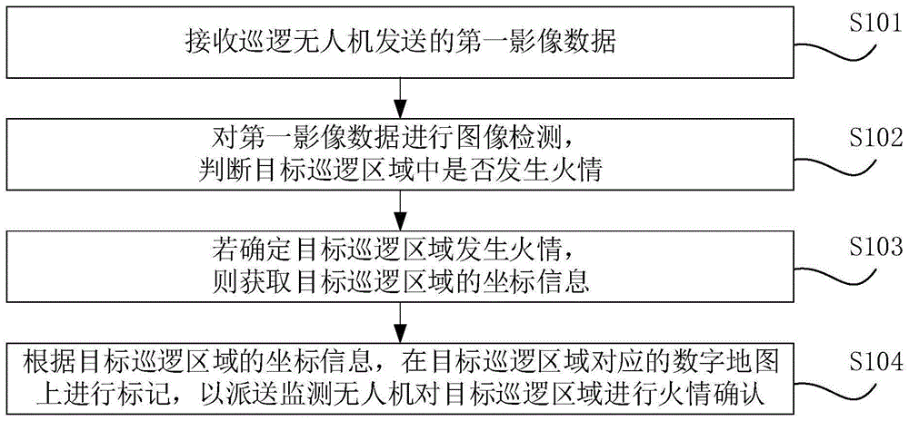
图1是根据一示例性实施例提出的一种基于无人机的火情检测方法的流程图。如图1所示,基于无人机的火情检测方法包括如下步骤S101至步骤S104。Fig. 1 is a flowchart of a fire detection method based on a drone according to an exemplary embodiment. As shown in FIG. 1 , the fire detection method based on the drone includes the following steps S101 to S104.
在步骤S101中,接收巡逻无人机发送的第一影像数据。In step S101, the first image data sent by the patrol drone is received.
在本发明实施例中,第一影像数据为巡逻无人机在目标巡逻区域内巡逻时采集得到的影像数据。巡逻无人机可以理解为是用于执行巡逻任务的无人机。巡逻无人机包括影像采集设备,可以通过该影像采集设备采集目标巡逻区域的影像数据。在一示例中,影像采集设备可以是常规摄像头,也可以是红外热成像摄像头,可以根据实际需求进行配置。通过接收巡逻无人机发送的第一影像数据,可以快速了解目标巡逻区域内的实际情况,以便检测目标巡逻区域内是否发生异常。In the embodiment of the present invention, the first image data is the image data collected by the patrol drone when it patrols in the target patrol area. Patrol drones can be understood as drones used to perform patrol tasks. The patrol UAV includes an image acquisition device through which image data of a target patrol area can be collected. In an example, the image acquisition device may be a conventional camera or an infrared thermal imaging camera, which may be configured according to actual needs. By receiving the first image data sent by the patrol drone, it is possible to quickly understand the actual situation in the target patrol area, so as to detect whether there is an abnormality in the target patrol area.
在步骤S102中,对第一影像数据进行图像检测,判断目标巡逻区域中是否发生火情。In step S102, image detection is performed on the first image data to determine whether a fire occurs in the target patrol area.
在本发明实施例中,第一影像数据是由多帧图像数据构成的影像数据。因此,对第一影像数据进行图像检测,以确定第一影像数据中是否存在可以确认发生火情的特征数据,进而判断目标巡逻区域内是否发生火情。In the embodiment of the present invention, the first image data is image data composed of multiple frames of image data. Therefore, image detection is performed on the first image data to determine whether there is feature data that can confirm the occurrence of a fire in the first image data, and then determine whether a fire occurs in the target patrol area.
在一实施例中,若第一影像数据是采用常规摄像头采集得到的,则可以采用特征提取的方式,识别第一影像数据中是否包括浓烟数据(特征数据)。若第一影像数据中包括浓烟数据,则确定目标巡逻区域发生火情。若第一影像数据中未包括浓烟数据,则确定目标巡逻区域未发生火情。其中,浓烟数据是一种示例出能够确定目标巡逻区域发生火情的特征数据,在实际应用中,为提高的检测准确率,可以根据实际需求自行增加其他用于辅助判断目标巡逻区域是否发生火情的目标特征数据类型,在本发明中不进行限定。在一应用场景中,可以利用人工智能(Artificial Intelligence,AI)技术识别第一影像数据中是否包括浓烟数据。In an embodiment, if the first image data is collected by a conventional camera, feature extraction may be used to identify whether the first image data includes dense smoke data (feature data). If the first image data includes dense smoke data, it is determined that a fire occurs in the target patrol area. If the first image data does not include dense smoke data, it is determined that no fire occurs in the target patrol area. Among them, the dense smoke data is a kind of characteristic data that can determine the occurrence of fire in the target patrol area. In practical applications, in order to improve the detection accuracy, you can add other data to assist in judging whether the target patrol area has occurred. The target characteristic data type of the fire situation is not limited in the present invention. In an application scenario, artificial intelligence (AI) technology may be used to identify whether the first image data includes dense smoke data.
在另一实施例中,若第一影像数据为巡逻无人机通过红外传感器采集得到的红外数据则可以利用红外热成像技术对第一影像数据进行图像检测,识别第一影像数据的像素值是否大于或者小于指定像素阈值。其中,指定像素阈值可以理解为已确定发生火情时热源对应的像素最小值。红外传感器可以理解为是部署在红外热成像摄像头上的传感器。若第一影像数据的像素值大于或者等于指定像素阈值,则表征目标巡逻区域的温度过高,可以确定目标巡逻区域发生火情。若第一影像数据的像素值小于指定像素阈值,则表征目标巡逻区域的温度较低,确定目标巡逻区域发生火情。In another embodiment, if the first image data is infrared data collected by a patrol drone through an infrared sensor, infrared thermal imaging technology can be used to perform image detection on the first image data to identify whether the pixel value of the first image data is Greater or less than the specified pixel threshold. Wherein, the specified pixel threshold can be understood as the minimum value of the pixel corresponding to the heat source when it is determined that a fire occurs. An infrared sensor can be understood as a sensor deployed on an infrared thermal imaging camera. If the pixel value of the first image data is greater than or equal to the specified pixel threshold, it indicates that the temperature of the target patrol area is too high, and it can be determined that a fire has occurred in the target patrol area. If the pixel value of the first image data is smaller than the specified pixel threshold, it indicates that the temperature of the target patrol area is low, and it is determined that a fire occurs in the target patrol area.
在步骤S103中,若确定目标巡逻区域发生火情,则获取目标巡逻区域的坐标信息。In step S103, if it is determined that a fire occurs in the target patrol area, coordinate information of the target patrol area is acquired.
在本发明实施例中,若确定目标巡逻区域发生火情,则获取目标巡逻区域的坐标信息,以便对目标巡逻区域进行定位,明确该目标巡逻区域的具体位置。In the embodiment of the present invention, if it is determined that a fire occurs in the target patrol area, the coordinate information of the target patrol area is obtained, so as to locate the target patrol area and clarify the specific location of the target patrol area.
在步骤S104中,根据目标巡逻区域的坐标信息,在目标巡逻区域对应的数字地图上进行标记,以派送监测无人机对目标巡逻区域进行火情确认。In step S104, according to the coordinate information of the target patrol area, mark it on the digital map corresponding to the target patrol area, so as to send a monitoring drone to confirm the fire situation in the target patrol area.
在本发明实施例中,监测无人机可以理解为是用于获取目标巡逻区域实时影像的无人机。相关人员可以根据监测无人机实时回传的第二影像数据对目标巡逻区域是否发生火情进行确认,进而提高火情检测的有效性,避免误检测的情况发生,从而有助于提高火情检测的准确率。In the embodiment of the present invention, the monitoring UAV can be understood as a UAV used to obtain real-time images of the target patrol area. Relevant personnel can confirm whether a fire has occurred in the target patrol area according to the second image data returned by the monitoring drone in real time, thereby improving the effectiveness of fire detection and avoiding false detections, thereby helping to improve fire detection. detection accuracy.
在一示例中,巡逻无人机和监测无人机可以是同一无人机,进而有助于节省检测成本。在另一示例中,巡逻无人机和监测无人机可以是两部独立的无人机,用于分别执行对应不同的任务。通过派送监测无人机对目标巡逻区域的火情进行确认时,可以根据监测无人机的飞行路程确定获取的目标巡逻区域的坐标信息是否正确,进而有助于提高火情检测的准确率。In an example, the patrol drone and the monitoring drone may be the same drone, which helps to save detection costs. In another example, the patrol drone and the monitoring drone may be two independent drones, which are used to perform different tasks respectively. When the fire situation in the target patrol area is confirmed by sending the monitoring UAV, it can be determined whether the acquired coordinate information of the target patrol area is correct according to the flight distance of the monitoring UAV, which in turn helps to improve the accuracy of fire detection.
通过上述实施例,通过对巡逻无人机采集的影像数据进行图像检测,确定目标巡逻区域是否发生火情,能够提高针对火情进行检测的效率,以便能够及时发现火情,减少人为参与,使得到的检测结果更具有客观性,有助于提高火情检测的准确率。Through the above-mentioned embodiments, by performing image detection on the image data collected by the patrol drone, it is determined whether a fire occurs in the target patrol area, and the efficiency of fire detection can be improved, so that the fire can be discovered in time, and human participation can be reduced. The detection results obtained are more objective and help to improve the accuracy of fire detection.
在一实施例中,目标巡逻区域可以采用下述方式进行确定:获取待进行火情监测的指定区域的数字地图。根据指定尺寸对数字地图进行区域划分,得到多个巡逻区域,并为每一个巡逻区域配置一个巡逻无人机,以通过巡逻无人机根据确定的目标巡逻频率采集其对应的巡逻区域的第一影像数据。其中,巡逻无人机对应的巡逻区域可以采用目标巡逻区域进行代称。例如,指定区域是可以是xx地区的森林。指定尺寸可以是1km*1km。指定区域和指定尺寸可以根据实际需求进行设定,在本发明中不进行限定。In an embodiment, the target patrol area may be determined in the following manner: obtain a digital map of the designated area to be monitored for fire. Divide the digital map into areas according to the specified size to obtain multiple patrol areas, and configure a patrol drone for each patrol area, so that the patrol drone can collect the first data of the corresponding patrol area according to the determined target patrol frequency. Image data. Wherein, the patrol area corresponding to the patrol UAV can be referred to as the target patrol area. For example, the designated area is a forest which may be xx area. The specified size can be 1km*1km. The designated area and designated size can be set according to actual needs, which are not limited in the present invention.
图2是根据一示例性实施例提出的另一种基于无人机的火情检测方法的流程图。如图2所示,基于无人机的火情检测方法包括如下步骤。Fig. 2 is a flow chart of another fire detection method based on a drone according to an exemplary embodiment. As shown in Figure 2, the UAV-based fire detection method includes the following steps.
在步骤S201中,获取目标巡逻区域的目标天气数据。In step S201, the target weather data of the target patrol area is acquired.
在本发明实施例中,目标巡逻区域的目标天气数据可以通过当地天文台监测到的数据进行获取,也可以由目标巡逻区域对应的管理处的相关人员自行观测得到。通过获取目标巡逻区域的目标天气数据,能够确定目标巡逻区域的天气情况,进而在规划巡逻无人机的目标巡逻频率时,能够进行合理规格,以便当目标巡逻区域发生火情时,能够及时发现。In the embodiment of the present invention, the target weather data of the target patrol area can be obtained through the data monitored by the local observatory, or can be obtained by the relevant personnel of the management office corresponding to the target patrol area. By obtaining the target weather data of the target patrol area, the weather conditions of the target patrol area can be determined, and then when planning the target patrol frequency of the patrol drone, reasonable specifications can be made so that when a fire occurs in the target patrol area, it can be discovered in time .
在步骤S202中,根据预置的多个天气数据与巡逻频率之间的对应关系,确定巡逻无人机在目标天气数据下对目标巡逻区域进行巡逻的目标巡逻频率。In step S202, a target patrol frequency for the patrol UAV to patrol the target patrol area under the target weather data is determined according to the correspondence between a plurality of preset weather data and the patrol frequency.
在本发明实施例中,预先建立多个天气数据与巡逻频率之间的对应关系,以便控制巡逻无人机在不同天气数据下采用不同的巡逻频率进行巡逻。在一示例中,在建立对应关系时,可以根据在当前天气数据下容易导致目标巡逻区域发生火情的发生率确定对应的巡逻频率,以便在进行火情检测时,能够及时发现火情。In the embodiment of the present invention, the corresponding relationship between a plurality of weather data and patrol frequencies is established in advance, so as to control the patrol UAV to perform patrols with different patrol frequencies under different weather data. In an example, when establishing the corresponding relationship, the corresponding patrol frequency can be determined according to the occurrence rate of fire in the target patrol area under the current weather data, so that the fire can be found in time when the fire detection is performed.
在一实施场景中,预先建立多个天气数据与巡逻频率之间的对应关系可以包括:在常规天气数据下,对应的巡逻频率为4小时/次;在湿度低于60%的天气数据下,对应的巡逻频率为3小时/次;在雷暴天气数据下,对应的巡逻频率为3小时/次;在雨雪天气数据下,对应的巡逻频率为0,即暂停巡逻。进而当获取的目标天气数据为常规天气数据时,则确定巡逻无人机的目标巡逻频率为4小时/次。当获取的目标天气数据为湿度低于60%的天气数据时,确定巡逻无人机的目标巡逻频率为3小时/次。当获取的目标天气数据为雨雪天气数据时,确定巡逻无人机的目标巡逻频率为3小时/次。当获取的目标天气数据为雷暴天气数据时,确定巡逻无人机的目标巡逻频率为0。In an implementation scenario, pre-establishing the correspondence between multiple weather data and patrol frequencies may include: under conventional weather data, the corresponding patrol frequency is 4 hours/time; under weather data with humidity lower than 60%, The corresponding patrol frequency is 3 hours/time; under the thunderstorm weather data, the corresponding patrol frequency is 3 hours/time; under the rain and snow weather data, the corresponding patrol frequency is 0, that is, the patrol is suspended. Furthermore, when the acquired target weather data is conventional weather data, it is determined that the target patrol frequency of the patrol UAV is 4 hours/time. When the acquired target weather data is the weather data with humidity lower than 60%, the target patrol frequency of the patrol UAV is determined to be 3 hours/time. When the acquired target weather data is rain and snow weather data, the target patrol frequency of the patrol UAV is determined to be 3 hours/time. When the acquired target weather data is thunderstorm weather data, it is determined that the target patrol frequency of the patrol UAV is 0.
在步骤S203中,根据目标巡逻频率,控制巡逻无人机在目标巡逻区域内巡逻。In step S203, the patrol UAV is controlled to patrol within the target patrol area according to the target patrol frequency.
在步骤S204中,接收巡逻无人机发送的第一影像数据。In step S204, the first image data sent by the patrol drone is received.
在步骤S205中,对第一影像数据进行图像检测,判断目标巡逻区域中是否发生火情。In step S205, image detection is performed on the first image data to determine whether a fire occurs in the target patrol area.
在步骤S206中,若确定目标巡逻区域发生火情,则获取目标巡逻区域的坐标信息。In step S206, if it is determined that a fire occurs in the target patrol area, coordinate information of the target patrol area is acquired.
在步骤S207中,根据目标巡逻区域的坐标信息,在目标巡逻区域对应的数字地图上进行标记,以派送监测无人机对目标巡逻区域进行火情确认。In step S207, according to the coordinate information of the target patrol area, mark it on the digital map corresponding to the target patrol area, so as to dispatch the monitoring UAV to confirm the fire situation in the target patrol area.
通过上述实施例,可以根据目标巡逻区域的目标天气数据,确定巡逻无人机的对目标巡逻区域进行巡逻的目标巡逻频率,进而进行针对性的巡逻,从而有助于当目标巡逻区域发生火情时,及时对其进行确认。Through the above-mentioned embodiment, the target patrol frequency for patrolling the target patrol area of the patrol drone can be determined according to the target weather data of the target patrol area, and then targeted patrols can be carried out, which helps when a fire occurs in the target patrol area , confirm it in time.
在一实施例中,目标巡逻区域的目标天气数据还可以通过巡逻无人机发送的第一影像数据进行确定,进而能够及时确定目标巡逻区域的天气是否发生变化,以便及时调整巡逻无人机针对目标巡逻区域进行巡逻的目标巡逻频率,从而有助于提高巡逻有效性。在一例中,可以采用人工判断的方式,通过第一影像数据获取目标天气数据。In one embodiment, the target weather data of the target patrol area can also be determined through the first image data sent by the patrol drone, and then it can be determined in time whether the weather in the target patrol area changes, so as to adjust the patrol drone in time. The target patrol frequency at which the target patrol area is patrolled, thereby helping to improve patrol effectiveness. In one example, the target weather data can be acquired through the first image data by manual judgment.
在另一实施例中,可以通过电子设备的控制端根据接收到的目标天气参数调整目标巡逻频率。In another embodiment, the target patrol frequency can be adjusted through the control terminal of the electronic device according to the received target weather parameters.
图3是根据一示例性实施例提出的又一种基于无人机的火情检测方法的流程图。如图3所示,基于无人机的火情检测方法包括如下步骤。Fig. 3 is a flowchart of another fire detection method based on a drone according to an exemplary embodiment. As shown in Figure 3, the UAV-based fire detection method includes the following steps.
在步骤S301中,接收巡逻无人机发送的第一影像数据。In step S301, the first image data sent by the patrol drone is received.
在步骤S302中,对第一影像数据进行图像检测,判断目标巡逻区域中是否发生火情。In step S302, image detection is performed on the first image data to determine whether a fire occurs in the target patrol area.
在步骤S303中,若确定目标巡逻区域发生火情,则获取目标巡逻区域的坐标信息。In step S303, if it is determined that a fire occurs in the target patrol area, coordinate information of the target patrol area is acquired.
在步骤S304中,根据目标巡逻区域的坐标信息,在目标巡逻区域对应的数字地图上进行标记,以派送监测无人机对目标巡逻区域进行火情确认。In step S304, according to the coordinate information of the target patrol area, mark it on the digital map corresponding to the target patrol area, so as to dispatch the monitoring UAV to confirm the fire situation in the target patrol area.
在步骤S305中,接收监测无人机发送的第二影像数据。In step S305, the second image data sent by the monitoring drone is received.
在本发明实施例中,第二影像数据为监测无人机采集、回传的影像数据,以供相关人员根据接收的第二影像数据确定目标巡逻区域发生火情是否属实。In the embodiment of the present invention, the second image data is the image data collected and returned by the monitoring drone, so that relevant personnel can determine whether the fire in the target patrol area is true or not based on the received second image data.
在步骤S306中,对第二影像数据进行图像检测,若确定目标巡逻区域发生火情,则向监测无人机发送提示指令,以使监测无人机根据接收的提示指令向目标人员发送火情提示信息。In step S306, image detection is performed on the second image data, and if it is determined that a fire occurs in the target patrol area, a prompt instruction is sent to the monitoring UAV, so that the monitoring UAV sends a fire situation to the target person according to the received prompt instruction Prompt information.
在本发明实施例中,火情提示信息为用于提示目标巡逻区域发生火情的信息。通过对第二影像数据进行图像检测,在确定目标巡逻区域发生火情时,向监测无人机发送提示指令,以使监测无人机根据接收的提示指令向目标人员发送火情提示信息,及时疏散人群。目标人员可以是目标巡逻区域的管理员,或者火情防护人员,可以根据具体实际情况进行设定,在本发明中不进行限定。In the embodiment of the present invention, the fire notification information is information used to remind the fire situation in the target patrol area. By performing image detection on the second image data, when it is determined that a fire occurs in the target patrol area, a prompt instruction is sent to the monitoring UAV, so that the monitoring UAV sends a fire prompt message to the target person according to the received prompt instruction, and timely disperse the crowd. The target person can be the administrator of the target patrol area, or the fire protection personnel, which can be set according to the actual situation, and is not limited in the present invention.
在一示例中,火情提示信息包括目标巡逻区域的名称、目标巡逻区域的坐标信息以及目标巡逻区域的相对反方向。其中,坐标信息可以包括目标巡逻区域的经度值和纬度值。In an example, the fire notification information includes a name of the target patrol area, coordinate information of the target patrol area, and a relative opposite direction of the target patrol area. Wherein, the coordinate information may include a longitude value and a latitude value of the target patrol area.
通过上述实施例,能够在确定目标巡逻区域发生火情时,及时告知目标人员有关目标巡逻区域的火情提示信息。Through the above embodiments, when it is determined that a fire occurs in the target patrol area, the target personnel can be informed of the fire prompt information about the target patrol area in time.
图4是根据一示例性实施例提出的又一种基于无人机的火情检测方法的流程图。如图4所示,基于无人机的火情检测方法包括如下步骤。Fig. 4 is a flow chart of another fire detection method based on a drone according to an exemplary embodiment. As shown in Figure 4, the UAV-based fire detection method includes the following steps.
在步骤S401中,接收巡逻无人机发送的第一影像数据。In step S401, the first image data sent by the patrol drone is received.
在步骤S402中,对第一影像数据进行图像检测,判断目标巡逻区域中是否发生火情。In step S402, image detection is performed on the first image data to determine whether a fire occurs in the target patrol area.
在步骤S403中,若确定目标巡逻区域发生火情,则获取目标巡逻区域的坐标信息。In step S403, if it is determined that a fire occurs in the target patrol area, coordinate information of the target patrol area is acquired.
在步骤S404中,根据目标巡逻区域的坐标信息,在目标巡逻区域对应的数字地图上进行标记,以派送监测无人机对目标巡逻区域进行火情确认。In step S404, according to the coordinate information of the target patrol area, mark it on the digital map corresponding to the target patrol area, so as to send a monitoring drone to confirm the fire situation in the target patrol area.
在步骤S405中,接收监测无人机发送的第二影像数据。In step S405, the second image data sent by the monitoring drone is received.
在步骤S406中,对第二影像数据进行图像检测,若确定目标巡逻区域发生火情,则向监测无人机发送提示指令,以使监测无人机根据接收的提示指令向目标人员发送火情提示信息。In step S406, image detection is performed on the second image data, and if it is determined that a fire occurs in the target patrol area, a prompt instruction is sent to the monitoring UAV, so that the monitoring UAV sends a fire situation to the target person according to the received prompt instruction Prompt information.
在步骤S407中,向广播无人机发送广播指令,以使广播无人机响应于接收到的广播指令广播火情提示信息。In step S407, a broadcast instruction is sent to the broadcast drone, so that the broadcast drone responds to the received broadcast instruction to broadcast fire prompt information.
在本发明实施例中,火情提示信息包括目标巡逻区域的名称、目标巡逻区域的坐标信息以及目标巡逻区域的相对反方向。广播无人机可以理解为是用于执行广播任务的无人机。在一例中,广播无人机可以与监测无人机是同一无人机。通过广播无人机广播火情提示信息,有利于指引相关人员能够根据广播的火情提示信息向与发生火情的目标巡逻区域的相对反方向进行撤离,进而有助于减少人员伤亡损失。In the embodiment of the present invention, the fire notification information includes the name of the target patrol area, the coordinate information of the target patrol area, and the relative opposite direction of the target patrol area. Broadcasting drones can be understood as drones used to perform broadcasting tasks. In one example, the broadcasting drone may be the same drone as the monitoring drone. By broadcasting the fire warning information broadcasted by the UAV, it is beneficial to guide the relevant personnel to evacuate in the opposite direction of the target patrol area where the fire occurs according to the broadcast fire warning information, thereby helping to reduce casualties.
通过上述实施例,能够在确定目标巡逻区域发生火情时,通过广播无人机得广播,及时疏散人群,进而减少因火情导致人员伤亡的情况发生。Through the above-mentioned embodiments, when a fire occurs in the target patrol area, the broadcast of the drone can be broadcast to evacuate the crowd in time, thereby reducing the occurrence of casualties caused by the fire.
在一实施场景中,基于无人机对目标森林进行巡逻时,可以预先建立目标森林的数字地图,进而根据指定尺寸(1km*1km)对数字地图进行区域划分,得到多个巡逻区域,并分别为每一个巡逻区域配置一个巡逻无人机,并确定每一个巡逻无人机在巡逻其目标巡逻区域的目标巡逻区域。可以根据获取的目标巡逻区域的目标天气数据,以及预置的多个天气数据与巡逻频率之间的对应关系,调整巡逻无人机对目标巡逻区域进行巡逻的目标巡逻频率,以便当目标巡逻区域发生火情时能够及时发现。In an implementation scenario, when patrolling the target forest based on the UAV, a digital map of the target forest can be established in advance, and then the digital map can be divided into areas according to the specified size (1km*1km), and multiple patrol areas can be obtained. Configure a patrol UAV for each patrol area, and determine the target patrol area where each patrol UAV is patrolling its target patrol area. According to the acquired target weather data of the target patrol area, and the corresponding relationship between the preset multiple weather data and the patrol frequency, the target patrol frequency of the patrol UAV to patrol the target patrol area can be adjusted so that when the target patrol area When a fire occurs, it can be found in time.
接收巡逻无人机发送的第一影像数据,通过对其进行图像检测,确定目标巡逻区域是否发生火情。若目标巡逻区域发生火情,则获取该目标巡逻区域的坐标信息,并在数字地图上进行标记,用于指示火情判定点。派送监测无人机对目标巡逻区域进行火情确认,接收监测无人机发送的第二影像数据。对第二影像数据进行图像检测,若确定目标巡逻区域发生火情,则向监测无人机发送提示指令。监测无人机响应于接收的提示指令,向目标人员发送火情提示信息。在确定目标巡逻区域发生火情后,向广播无人机发送广播指令。广播无人机响应于接收到的广播指令广播火情提示信息,以疏导相关人员向与发生火情的目标巡逻区域相对反方向撤离,以减少因火情导致人员伤亡的情况发生。Receive the first image data sent by the patrol drone, and determine whether there is a fire in the target patrol area through image detection. If a fire occurs in the target patrol area, the coordinate information of the target patrol area is obtained and marked on the digital map to indicate the fire judgment point. Send the monitoring UAV to confirm the fire situation in the target patrol area, and receive the second image data sent by the monitoring UAV. Image detection is performed on the second image data, and if it is determined that a fire occurs in the target patrol area, a prompt command is sent to the monitoring UAV. The monitoring UAV sends fire notification information to the target personnel in response to the received prompt instruction. After it is determined that a fire has occurred in the target patrol area, a broadcast instruction is sent to the broadcast drone. The broadcast UAV broadcasts the fire prompt information in response to the received broadcast instructions to guide the relevant personnel to evacuate in the opposite direction to the target patrol area where the fire occurs, so as to reduce the occurrence of casualties caused by the fire.
基于相同发明构思,本发明还提供一种基于无人机的火情检测装置。Based on the same inventive concept, the present invention also provides a fire detection device based on an unmanned aerial vehicle.
图5是根据一示例性实施例提出的一种基于无人机的火情检测装置的结构框图。如图5所示,基于无人机的火情检测装置包括第一接收单元501、图像检测单元502、第一获取单元503和标记单元504。Fig. 5 is a structural block diagram of a fire detection device based on a drone according to an exemplary embodiment. As shown in FIG. 5 , the UAV-based fire detection device includes a
第一接收单元501,用于接收巡逻无人机发送的第一影像数据,第一影像数据为巡逻无人机在目标巡逻区域内巡逻时采集得到的影像数据。The
图像检测单元502,用于对第一影像数据进行图像检测,判断目标巡逻区域中是否发生火情。The
第一获取单元503,用于若确定目标巡逻区域发生火情,则获取目标巡逻区域的坐标信息。The first acquiring
标记单元504,用于根据目标巡逻区域的坐标信息,在目标巡逻区域对应的数字地图上进行标记,以派送监测无人机对目标巡逻区域进行火情确认。The marking
在一实施例中,图像检测单元502包括:第一检测单元,用于对第一影像数据进行特征提取,识别第一影像数据中是否包括浓烟数据;第一确定单元,用于若第一影像数据中包括浓烟数据,则确定目标巡逻区域发生火情;第二确定单元,用于若第一影像数据中未包括浓烟数据,则确定目标巡逻区域未发生火情。In one embodiment, the
在另一实施例中,图像检测单元502包括:第二检测单元,用于对第一影像数据进行图像检测,若第一影像数据的像素值大于或者等于指定像素阈值,则确定目标巡逻区域发生火情,第一影像数据为巡逻无人机通过红外传感器采集得到的红外数据;第三确定单元,用于若第一影像数据的像素值小于指定像素阈值,则确定目标巡逻区域未发生火情。In another embodiment, the
在又一实施例中,装置还包括:第二获取单元,用于获取目标巡逻区域的目标天气数据;第四确定单元,用于根据预置的多个天气数据与巡逻频率之间的对应关系,确定巡逻无人机在目标天气数据下对目标巡逻区域进行巡逻的目标巡逻频率;第一控制单元,用于根据目标巡逻频率,控制巡逻无人机在目标巡逻区域内巡逻。In yet another embodiment, the device further includes: a second acquisition unit, configured to acquire target weather data in the target patrol area; a fourth determination unit, configured to obtain the corresponding relationship between a plurality of preset weather data and the patrol frequency , determine the target patrol frequency for the patrol drone to patrol the target patrol area under the target weather data; the first control unit is used to control the patrol drone to patrol in the target patrol area according to the target patrol frequency.
在又一实施例中,第二获取单元包括:第二获取子单元,用于通过巡逻无人机发送的第一影像数据获取目标巡逻区域的目标天气数据。In yet another embodiment, the second acquisition unit includes: a second acquisition subunit, configured to acquire target weather data of the target patrol area through the first image data sent by the patrol drone.
在又一实施例中,装置还包括:接收单元,用于接收监测无人机发送的第二影像数据;第二控制单元,用于对第二影像数据进行图像检测,若确定目标巡逻区域发生火情,则向监测无人机发送提示指令,以使监测无人机根据接收的提示指令向目标人员发送火情提示信息,火情提示信息为用于提示目标巡逻区域发生火情的信息。In yet another embodiment, the device further includes: a receiving unit, configured to receive the second image data sent by the monitoring drone; a second control unit, configured to perform image detection on the second image data, and if it is determined that the target patrol area occurs For the fire situation, a reminder instruction is sent to the monitoring UAV, so that the monitoring UAV sends a fire notification message to the target person according to the received notification instruction. The fire notification message is information used to remind the target patrol area of a fire.
在又一实施例中,装置还包括:发送单元,用于向广播无人机发送广播指令,以使广播无人机响应于接收到的广播指令广播火情提示信息;火情提示信息包括目标巡逻区域的名称、目标巡逻区域的坐标信息以及目标巡逻区域的相对反方向。In yet another embodiment, the device further includes: a sending unit, configured to send a broadcast instruction to the broadcasting UAV, so that the broadcasting UAV broadcasts fire prompt information in response to the received broadcast instruction; the fire prompt information includes the target The name of the patrol area, the coordinate information of the target patrol area, and the relative opposite direction of the target patrol area.
上述基于无人机的火情检测装置的具体限定以及有益效果可以参见上文中对于基于无人机的火情检测方法的限定,在此不再赘述。上述各个模块可全部或部分通过软件、硬件及其组合来实现。上述各模块可以硬件形式内嵌于或独立于电子设备中的处理器中,也可以以软件形式存储于电子设备中的存储器中,以便于处理器调用执行以上各个模块对应的操作。For the specific limitations and beneficial effects of the above-mentioned UAV-based fire detection device, please refer to the above-mentioned definition of the UAV-based fire detection method, which will not be repeated here. Each of the above-mentioned modules can be fully or partially realized by software, hardware and a combination thereof. The above-mentioned modules can be embedded in or independent of the processor in the electronic device in the form of hardware, and can also be stored in the memory of the electronic device in the form of software, so that the processor can invoke and execute the corresponding operations of the above-mentioned modules.
图6是根据一示例性实施例提出的一种电子设备的硬件结构示意图。如图6所示,该设备包括一个或多个处理器610以及存储器620,存储器620包括持久内存、易失内存和硬盘,图6中以一个处理器610为例。该设备还可以包括:输入装置630和输出装置640。Fig. 6 is a schematic diagram of a hardware structure of an electronic device according to an exemplary embodiment. As shown in FIG. 6 , the device includes one or
处理器610、存储器620、输入装置630和输出装置640可以通过总线或者其他方式连接,图6中以通过总线连接为例。The
处理器610可以为中央处理器(Central Processing Unit,CPU)。处理器610还可以为其他通用处理器、数字信号处理器(Digital Signal Processor,DSP)、专用集成电路(Application Specific Integrated Circuit,ASIC)、现场可编程门阵列(Field-Programmable Gate Array,FPGA)或者其他可编程逻辑器件、分立门或者晶体管逻辑器件、分立硬件组件等芯片,或者上述各类芯片的组合。通用处理器可以是微处理器或者该处理器也可以是任何常规的处理器等。The
存储器620作为一种非暂态计算机可读存储介质,包括持久内存、易失内存和硬盘,可用于存储非暂态软件程序、非暂态计算机可执行程序以及模块,如本申请实施例中的业务管理方法对应的程序指令/模块。处理器610通过运行存储在存储器620中的非暂态软件程序、指令以及模块,从而执行服务器的各种功能应用以及数据处理,即实现上述任意一种基于无人机的火情检测方法。The
存储器620可以包括存储程序区和存储数据区,其中,存储程序区可存储操作系统、至少一个功能所需要的应用程序;存储数据区可存储根据、需要使用的数据等。此外,存储器620可以包括高速随机存取存储器,还可以包括非暂态存储器,例如至少一个磁盘存储器件、闪存器件、或其他非暂态固态存储器件。在一些实施例中,存储器620可选包括相对于处理器610远程设置的存储器,这些远程存储器可以通过网络连接至数据处理装置。上述网络的实例包括但不限于互联网、企业内部网、局域网、移动通信网及其组合。The
输入装置630可接收输入的数字或字符信息,以及产生与用户设置以及功能控制有关的键信号输入。输出装置640可包括显示屏等显示设备。The
一个或者多个模块存储在存储器620中,当被一个或者多个处理器610执行时,执行如图1-图4所示的方法。One or more modules are stored in the
上述产品可执行本发明实施例所提供的方法,具备执行方法相应的功能模块和有益效果。未在本实施例中详尽描述的技术细节,具体可参见如图1-图4所示的实施例中的相关描述。The above-mentioned products can execute the methods provided by the embodiments of the present invention, and have corresponding functional modules and beneficial effects for executing the methods. For technical details that are not exhaustively described in this embodiment, please refer to the related descriptions in the embodiments shown in FIGS. 1-4 for details.
本发明实施例还提供了一种非暂态计算机存储介质,计算机存储介质存储有计算机可执行指令,该计算机可执行指令可执行上述任意方法实施例中的认证方法。其中,存储介质可为磁碟、光盘、只读存储记忆体(Read-Only Memory,ROM)、随机存储记忆体(RandomAccess Memory,RAM)、快闪存储器(Flash Memory)、硬盘(Hard Disk Drive,HDD)或固态硬盘(Solid-State Drive,SSD)等;存储介质还可以包括上述种类的存储器的组合。The embodiment of the present invention also provides a non-transitory computer storage medium, the computer storage medium stores computer-executable instructions, and the computer-executable instructions can execute the authentication method in any of the above method embodiments. Wherein, the storage medium may be a magnetic disk, an optical disk, a read-only memory (Read-Only Memory, ROM), a random access memory (Random Access Memory, RAM), a flash memory (Flash Memory), a hard disk (Hard Disk Drive, HDD) or solid-state hard drive (Solid-State Drive, SSD), etc.; the storage medium may also include a combination of the above-mentioned types of memory.
显然,上述实施例仅仅是为清楚地说明所作的举例,而并非对实施方式的限定。对于所属领域的普通技术人员来说,在上述说明的基础上还可以做出其它不同形式的变化或变动。这里无需也无法对所有的实施方式予以穷举。而由此所引伸出的显而易见的变化或变动仍处于本发明创造的保护范围之中。Apparently, the above-mentioned embodiments are only examples for clear description, rather than limiting the implementation. For those of ordinary skill in the art, other changes or changes in different forms can be made on the basis of the above description. It is not necessary and impossible to exhaustively list all the implementation manners here. And the obvious changes or changes derived therefrom are still within the scope of protection of the present invention.
Claims (10)
Priority Applications (1)
| Application Number | Priority Date | Filing Date | Title |
|---|---|---|---|
| CN202211273444.3A CN115620179A (en) | 2022-10-18 | 2022-10-18 | Unmanned aerial vehicle-based fire detection method and device, electronic equipment and medium |
Applications Claiming Priority (1)
| Application Number | Priority Date | Filing Date | Title |
|---|---|---|---|
| CN202211273444.3A CN115620179A (en) | 2022-10-18 | 2022-10-18 | Unmanned aerial vehicle-based fire detection method and device, electronic equipment and medium |
Publications (1)
| Publication Number | Publication Date |
|---|---|
| CN115620179A true CN115620179A (en) | 2023-01-17 |
Family
ID=84862248
Family Applications (1)
| Application Number | Title | Priority Date | Filing Date |
|---|---|---|---|
| CN202211273444.3A Pending CN115620179A (en) | 2022-10-18 | 2022-10-18 | Unmanned aerial vehicle-based fire detection method and device, electronic equipment and medium |
Country Status (1)
| Country | Link |
|---|---|
| CN (1) | CN115620179A (en) |
Cited By (2)
| Publication number | Priority date | Publication date | Assignee | Title |
|---|---|---|---|---|
| CN115880598A (en) * | 2023-02-15 | 2023-03-31 | 深圳市蜉飞科技有限公司 | Ground image detection method based on unmanned aerial vehicle and related device |
| CN116580540A (en) * | 2023-04-14 | 2023-08-11 | 北京德风新征程科技股份有限公司 | Information issuing method, device, electronic equipment and computer readable medium |
Citations (5)
| Publication number | Priority date | Publication date | Assignee | Title |
|---|---|---|---|---|
| CN104715556A (en) * | 2015-04-02 | 2015-06-17 | 无锡桑尼安科技有限公司 | Fire alarm method based on aerial photography |
| CN107741747A (en) * | 2017-09-25 | 2018-02-27 | 广东工商职业学院 | Automatic forest patrol system and method based on unmanned plane |
| CN108986386A (en) * | 2018-07-28 | 2018-12-11 | 闫旭 | The fireproof monitoring system deployed to ensure effective monitoring and control of illegal activities based on cloud |
| WO2021223125A1 (en) * | 2020-05-06 | 2021-11-11 | 深圳市大疆创新科技有限公司 | Patrol inspection method and system, unmanned aerial vehicle, ground control platform, and storage medium |
| KR20220021669A (en) * | 2020-08-14 | 2022-02-22 | 주식회사 에스피스퀘어 | Area patrol system with patrol drone |
-
2022
- 2022-10-18 CN CN202211273444.3A patent/CN115620179A/en active Pending
Patent Citations (5)
| Publication number | Priority date | Publication date | Assignee | Title |
|---|---|---|---|---|
| CN104715556A (en) * | 2015-04-02 | 2015-06-17 | 无锡桑尼安科技有限公司 | Fire alarm method based on aerial photography |
| CN107741747A (en) * | 2017-09-25 | 2018-02-27 | 广东工商职业学院 | Automatic forest patrol system and method based on unmanned plane |
| CN108986386A (en) * | 2018-07-28 | 2018-12-11 | 闫旭 | The fireproof monitoring system deployed to ensure effective monitoring and control of illegal activities based on cloud |
| WO2021223125A1 (en) * | 2020-05-06 | 2021-11-11 | 深圳市大疆创新科技有限公司 | Patrol inspection method and system, unmanned aerial vehicle, ground control platform, and storage medium |
| KR20220021669A (en) * | 2020-08-14 | 2022-02-22 | 주식회사 에스피스퀘어 | Area patrol system with patrol drone |
Cited By (2)
| Publication number | Priority date | Publication date | Assignee | Title |
|---|---|---|---|---|
| CN115880598A (en) * | 2023-02-15 | 2023-03-31 | 深圳市蜉飞科技有限公司 | Ground image detection method based on unmanned aerial vehicle and related device |
| CN116580540A (en) * | 2023-04-14 | 2023-08-11 | 北京德风新征程科技股份有限公司 | Information issuing method, device, electronic equipment and computer readable medium |
Similar Documents
| Publication | Publication Date | Title |
|---|---|---|
| US20210389293A1 (en) | Methods and Systems for Water Area Pollution Intelligent Monitoring and Analysis | |
| CN107014827A (en) | Transmission line of electricity defect analysis method based on image processing, device and system | |
| EP3163543B1 (en) | Alarming method and device | |
| CN113721621B (en) | Vehicle control method, device, electronic equipment and storage medium | |
| CN106651855A (en) | Image monitoring and shooting method for automatic identification and alarming of hidden troubles of power transmission line channel | |
| CN115620179A (en) | Unmanned aerial vehicle-based fire detection method and device, electronic equipment and medium | |
| CN114878005A (en) | Temperature detection method, device, system, electronic device and storage medium | |
| CN115169602B (en) | Maintenance method and device of power equipment, storage medium and computer equipment | |
| CN108318781A (en) | A method of the insulator remote monitoring based on infrared image and fault diagnosis | |
| CN109960969B (en) | Method, device and system for generating moving route | |
| CN113807209B (en) | Parking space detection method and device, electronic equipment and storage medium | |
| KR102250077B1 (en) | Method, device and computer readable storage medium for monitoring of license plate recognition rate | |
| CN110390226A (en) | Crowd's event recognition method, device, electronic equipment and system | |
| CN106546703A (en) | Air quality surveillance system, method and device | |
| WO2017054307A1 (en) | Recognition method and apparatus for user information | |
| CN103871185B (en) | The anti-external force processing method of transmission line of electricity, Apparatus and system | |
| CN114663404B (en) | Line defect identification method and device, electronic equipment and storage medium | |
| CN116580362B (en) | Transmission operation cross-system fusion data acquisition method and digital asset processing system | |
| CN117237873A (en) | Power grid engineering supervision method and device based on machine vision | |
| CN119027868A (en) | A sewage discharge detection method, system, equipment and medium | |
| CN118644922A (en) | A smart building security control method, system, terminal and storage medium | |
| CN113658120B (en) | Defect identification method and device for power equipment, computer equipment and storage medium | |
| CN111102987B (en) | Rescue vehicle tracking method, device, server and medium | |
| CN116824725A (en) | A method and system for intelligent management and protection of forest resources | |
| CN107731012A (en) | Aircraft supervisory systems |
Legal Events
| Date | Code | Title | Description |
|---|---|---|---|
| PB01 | Publication | ||
| PB01 | Publication | ||
| SE01 | Entry into force of request for substantive examination | ||
| SE01 | Entry into force of request for substantive examination |