CN115355907A - Autonomous navigation system and method based on millimeter wave sensing integrated unmanned equipment - Google Patents
Autonomous navigation system and method based on millimeter wave sensing integrated unmanned equipment Download PDFInfo
- Publication number
- CN115355907A CN115355907A CN202211279327.8A CN202211279327A CN115355907A CN 115355907 A CN115355907 A CN 115355907A CN 202211279327 A CN202211279327 A CN 202211279327A CN 115355907 A CN115355907 A CN 115355907A
- Authority
- CN
- China
- Prior art keywords
- millimeter wave
- positioning
- inertial navigation
- unmanned
- module
- Prior art date
- Legal status (The legal status is an assumption and is not a legal conclusion. Google has not performed a legal analysis and makes no representation as to the accuracy of the status listed.)
- Pending
Links
Images


Classifications
-
- G—PHYSICS
- G01—MEASURING; TESTING
- G01C—MEASURING DISTANCES, LEVELS OR BEARINGS; SURVEYING; NAVIGATION; GYROSCOPIC INSTRUMENTS; PHOTOGRAMMETRY OR VIDEOGRAMMETRY
- G01C21/00—Navigation; Navigational instruments not provided for in groups G01C1/00 - G01C19/00
- G01C21/10—Navigation; Navigational instruments not provided for in groups G01C1/00 - G01C19/00 by using measurements of speed or acceleration
- G01C21/12—Navigation; Navigational instruments not provided for in groups G01C1/00 - G01C19/00 by using measurements of speed or acceleration executed aboard the object being navigated; Dead reckoning
- G01C21/16—Navigation; Navigational instruments not provided for in groups G01C1/00 - G01C19/00 by using measurements of speed or acceleration executed aboard the object being navigated; Dead reckoning by integrating acceleration or speed, i.e. inertial navigation
- G01C21/165—Navigation; Navigational instruments not provided for in groups G01C1/00 - G01C19/00 by using measurements of speed or acceleration executed aboard the object being navigated; Dead reckoning by integrating acceleration or speed, i.e. inertial navigation combined with non-inertial navigation instruments
-
- H—ELECTRICITY
- H04—ELECTRIC COMMUNICATION TECHNIQUE
- H04W—WIRELESS COMMUNICATION NETWORKS
- H04W4/00—Services specially adapted for wireless communication networks; Facilities therefor
- H04W4/02—Services making use of location information
- H04W4/024—Guidance services
Landscapes
- Engineering & Computer Science (AREA)
- Radar, Positioning & Navigation (AREA)
- Remote Sensing (AREA)
- Automation & Control Theory (AREA)
- Physics & Mathematics (AREA)
- General Physics & Mathematics (AREA)
- Computer Networks & Wireless Communication (AREA)
- Signal Processing (AREA)
- Position Fixing By Use Of Radio Waves (AREA)
- Control Of Position, Course, Altitude, Or Attitude Of Moving Bodies (AREA)
Abstract
本发明公开了一种基于毫米波通感一体化无人设备的自主导航系统及方法,包括至少一个智能无人系统和至少一个移动通信基站,所述移动通信基站面向所有用户发送信号,信号包括但不限于毫米波信号;所述智能无人系统设于无人设备中,至少包括惯导定位系统;智能无人系统实时接收来自移动通信基站的毫米波信号,解码信号帧头中基站身份信息和位置信息的同时,根据信号的出射角、到达角和到达时延,估计出智能无人系统与基站间的相对位置,依据此位置,对自身惯导定位系统的累积误差进行校正,并且根据惯导定位和毫米波定位,确定自身位置,实现自主导航,充分利用自由空间中的毫米波信号,在不影响移动通信系统的前提下,实现高精度定位和自主导航。
The invention discloses an autonomous navigation system and method based on millimeter-wave synesthesia integrated unmanned equipment, including at least one intelligent unmanned system and at least one mobile communication base station, the mobile communication base station sends signals to all users, and the signals include But not limited to millimeter wave signals; the intelligent unmanned system is set in the unmanned equipment, at least including the inertial navigation positioning system; the intelligent unmanned system receives the millimeter wave signal from the mobile communication base station in real time, and decodes the identity information of the base station in the signal frame header At the same time as the position information, the relative position between the intelligent unmanned system and the base station is estimated according to the departure angle, arrival angle and arrival delay of the signal. Inertial navigation positioning and millimeter wave positioning, determine its own position, realize autonomous navigation, make full use of millimeter wave signals in free space, and realize high-precision positioning and autonomous navigation without affecting the mobile communication system.
Description
技术领域technical field
本发明属于无人系统控制和移动通信的技术领域,主要涉及了一种基于毫米波通感一体化无人设备的自主导航系统及方法。The invention belongs to the technical field of unmanned system control and mobile communication, and mainly relates to an autonomous navigation system and method based on millimeter-wave synesthesia integrated unmanned equipment.
背景技术Background technique
随着无人机、无人车、智能机器人等智能无人系统应用场景的拓展,人们对于无人系统的智能化需求不断提升。传统无人系统需要人为遥控,并且操作者需要实时观察无人系统的位置,来调整无人系统的移动轨迹。惯导系统的出现,使无人系统有了自主导航的能力。高精度的惯导系统可以实时记录无人系统的运行状态,从而绘制无人系统的运行路线进而实现对无人系统的实时定位。但是惯导系统存在累积误差,随着无人系统的移动,该误差值会不断增加。现有的研究中,人们会在无人系统中安装全球定位系统(GPS)来修正惯导系统的误差,但是在单个无人系统里安装GPS,增加了无人系统的成本。此外,GPS的定位精度较低,无法满足无人系统实时高精度定位的需求。With the expansion of application scenarios of intelligent unmanned systems such as drones, unmanned vehicles, and intelligent robots, people's demand for intelligent unmanned systems continues to increase. Traditional unmanned systems require human remote control, and the operator needs to observe the position of the unmanned system in real time to adjust the trajectory of the unmanned system. The emergence of the inertial navigation system has enabled the unmanned system to have the ability to navigate autonomously. The high-precision inertial navigation system can record the operating status of the unmanned system in real time, so as to draw the operating route of the unmanned system and realize the real-time positioning of the unmanned system. However, the inertial navigation system has cumulative error, and the error value will continue to increase as the unmanned system moves. In the existing research, people will install the Global Positioning System (GPS) in the unmanned system to correct the error of the inertial navigation system, but installing GPS in a single unmanned system increases the cost of the unmanned system. In addition, the positioning accuracy of GPS is low, which cannot meet the needs of real-time high-precision positioning of unmanned systems.
在现有的毫米波移动通信系统中,由于大规模多发多收系统(MassiveMIMO)的应用,以及毫米波波束具有一定的指向性,通信感知一体化成为了研究热点。随着物联网技术的发展,被放置各个场景中的小型传感器也被纳入了毫米波移动通信系统中,而这些技术都为无人系统的自动化控制和导航提供了客观条件。In the existing millimeter-wave mobile communication system, due to the application of the massive MIMO system (Massive MIMO) and the certain directivity of the millimeter-wave beam, the integration of communication and perception has become a research hotspot. With the development of the Internet of Things technology, small sensors placed in various scenes have also been incorporated into the millimeter wave mobile communication system, and these technologies provide objective conditions for the automatic control and navigation of unmanned systems.
发明内容Contents of the invention
本发明正是针对现有技术中无人系统实时高精度定位尚有缺陷的问题,提供一种基于毫米波通感一体化无人设备的自主导航系统及方法,包括至少一个智能无人系统和至少一个移动通信基站,所述移动通信基站面向所有用户发送信号,信号包括但不限于毫米波信号;所述智能无人系统设于无人设备中,至少包括惯导定位系统;智能无人系统实时接收来自移动通信基站的毫米波信号,解码信号帧头中基站身份信息和位置信息的同时,根据信号的出射角、到达角和到达时延,估计出智能无人系统与基站间的相对位置,依据此位置,对自身惯导定位系统的累积误差进行校正,并且根据惯导定位和毫米波定位,确定自身位置,实现自主导航。本发明使无人系统可以利用自由空间中的毫米波信号,在不影响移动通信系统的前提下,实现高精度定位和自主导航。The present invention is aimed at the problem of real-time high-precision positioning of unmanned systems in the prior art, and provides an autonomous navigation system and method based on millimeter-wave synesthesia-integrated unmanned equipment, including at least one intelligent unmanned system and At least one mobile communication base station, the mobile communication base station sends signals to all users, the signals include but not limited to millimeter wave signals; the intelligent unmanned system is set in the unmanned equipment, at least including the inertial navigation and positioning system; the intelligent unmanned system Real-time reception of millimeter-wave signals from mobile communication base stations, while decoding the identity information and location information of the base station in the signal frame header, estimate the relative position between the intelligent unmanned system and the base station according to the outgoing angle, arrival angle and arrival delay of the signal , according to this position, the cumulative error of its own inertial navigation positioning system is corrected, and according to the inertial navigation positioning and millimeter wave positioning, its own position is determined to realize autonomous navigation. The invention enables the unmanned system to use the millimeter wave signal in the free space to realize high-precision positioning and autonomous navigation without affecting the mobile communication system.
为了实现上述目的,本发明采取的技术方案是:基于毫米波通感一体化无人设备的自主导航系统,包括至少一个智能无人系统和至少一个移动通信基站,In order to achieve the above-mentioned purpose, the technical solution adopted by the present invention is: an autonomous navigation system based on millimeter-wave synesthesia integrated unmanned equipment, including at least one intelligent unmanned system and at least one mobile communication base station,
所述移动通信基站面向所有用户发送信号,所述信号包括但不限于毫米波信号;The mobile communication base station sends signals to all users, and the signals include but are not limited to millimeter wave signals;
所述智能无人系统设于无人设备中,至少包括惯导定位系统;智能无人系统实时接收来自移动通信基站的毫米波信号,解码信号帧头中基站身份信息和位置信息的同时,根据信号的出射角、到达角和到达时延,估计出智能无人系统与基站间的相对位置,依据此位置,对自身惯导定位系统的累积误差进行校正,并且根据惯导定位和毫米波定位,确定自身位置,实现自主导航。The intelligent unmanned system is set in the unmanned equipment, at least including the inertial navigation and positioning system; the intelligent unmanned system receives the millimeter wave signal from the mobile communication base station in real time, and decodes the identity information and position information of the base station in the signal frame header. The relative position between the intelligent unmanned system and the base station is estimated based on the outgoing angle, arrival angle and arrival delay of the signal. Based on this position, the cumulative error of its own inertial navigation positioning system is corrected, and according to the inertial navigation positioning and millimeter wave positioning , to determine its own position and realize autonomous navigation.
作为本发明的一种改进,所述智能无人系统包括无人设备、动力系统、毫米波感知系统和惯导系统,As an improvement of the present invention, the intelligent unmanned system includes unmanned equipment, a power system, a millimeter wave sensing system and an inertial navigation system,
所述动力系统用于为智能无人系统提供动力支持,包括电机、电池、功放模块及移动控制模块,所述无人设备与电机相连接,电池分别与电机和功放模块相连接,功放模块与移动控制模块相连接;The power system is used to provide power support for the intelligent unmanned system, including a motor, a battery, a power amplifier module and a mobile control module. The unmanned device is connected to the motor, the battery is connected to the motor and the power amplifier module, and the power amplifier module is connected to The mobile control module is connected;
所述毫米波感知系统用于接收和处理移动通信基站的毫米波信号,并反馈导航校正,包括毫米波信号接收模块、毫米波信号处理模块及导航校正模块,所述毫米波信号处理模块分别与毫米波信号接收模块和导航校正模块相连接;The millimeter-wave sensing system is used to receive and process millimeter-wave signals of mobile communication base stations, and feed back navigation corrections, including a millimeter-wave signal receiving module, a millimeter-wave signal processing module, and a navigation correction module, and the millimeter-wave signal processing modules are respectively connected with The millimeter wave signal receiving module is connected with the navigation correction module;
所述惯导定位系统包括惯导导航模块、惯导信息处理模块及惯导定位模块,所述惯导信息处理模块分别与惯导导航模块和惯导定位模块相连接,惯导导航模块还分别与移动控制模块和导航校正模块相连接。The inertial navigation system includes an inertial navigation module, an inertial navigation information processing module and an inertial navigation positioning module. Connect with mobile control module and navigation correction module.
作为本发明的一种改进,所述无人设备包括但不限于无人机、无人车或智能机器人。As an improvement of the present invention, the unmanned equipment includes but not limited to unmanned aerial vehicle, unmanned vehicle or intelligent robot.
作为本发明的一种改进,所述移动通信基站由射频通信发射天线、通信信号处理系统及射频通信接收天线组成,所述通信信号处理系统分别与射频通信发射天线和射频通信接收天线相连接,通信信号处理系统还连接到网关。As an improvement of the present invention, the mobile communication base station is composed of a radio frequency communication transmitting antenna, a communication signal processing system and a radio frequency communication receiving antenna, and the communication signal processing system is respectively connected with the radio frequency communication transmitting antenna and the radio frequency communication receiving antenna, The communication signal processing system is also connected to the gateway.
作为本发明的又一种改进,还包括传感器,所述智能无人系统接收传感器广播中的信息,根据传感器的身份信息、位置信息、射频信号的方向和时延,估测自身位置信息。As another improvement of the present invention, it also includes a sensor. The intelligent unmanned system receives the information broadcast by the sensor, and estimates its own position information according to the identity information, position information, direction and time delay of the radio frequency signal of the sensor.
作为本发明的又一种改进,对惯导定位系统中的累积误差设定阙值,当到达阙值时,智能无人系统停止运行,所述累积误差与时间呈正相关。As another improvement of the present invention, a threshold is set for the cumulative error in the inertial navigation and positioning system. When the threshold is reached, the intelligent unmanned system stops running, and the cumulative error is positively correlated with time.
为了实现上述目的,本发明还采取的技术方案是:基于毫米波通感一体化无人设备的自主导航方法,包括如下步骤:In order to achieve the above object, the technical solution adopted by the present invention is: an autonomous navigation method based on millimeter wave synesthesia integrated unmanned equipment, including the following steps:
S1:智能无人系统从初始点出发,获取初始点坐标,惯导定位系统通过监测和计算智能无人系统在移动中的行进方向、速率和姿态信息,与初始点位置相比对,指导智能无人系统的定位和导航;S1: The intelligent unmanned system starts from the initial point and obtains the coordinates of the initial point. The inertial navigation positioning system monitors and calculates the moving direction, speed and attitude information of the intelligent unmanned system, and compares it with the initial point position to guide the intelligence. Positioning and navigation of unmanned systems;
S2:智能无人系统行进过程中,收集移动通信基站在自由空间中发出的毫米波信号,并对信号进行解码,获取毫米波信号帧头中的基站身份信息和位置信息;S2: During the travel of the intelligent unmanned system, collect the millimeter wave signal sent by the mobile communication base station in free space, and decode the signal to obtain the identity information and location information of the base station in the frame header of the millimeter wave signal;
S3:智能无人系统对毫米波信号进行联合处理,提取出信道状态信息,利用射频定位算法,从信道状态信息中至少提取出毫米波信号的出射角、到达角和时延信息,从而估计出移动通信基站相对于智能无人系统的相对位置信息;S3: The intelligent unmanned system performs joint processing on the millimeter wave signal, extracts the channel state information, and uses the radio frequency positioning algorithm to extract at least the exit angle, arrival angle and time delay information of the millimeter wave signal from the channel state information, thereby estimating The relative position information of the mobile communication base station relative to the intelligent unmanned system;
S4:综合分析惯导定位系统和毫米波感知系统获取到的定位信息,估计出当前智能无人系统的准确位置,然后由毫米波感知系统中的导航校正模块,对智能无人系统的惯导导航模块进行误差校正。S4: Comprehensively analyze the positioning information obtained by the inertial navigation positioning system and the millimeter wave sensing system, estimate the accurate position of the current intelligent unmanned system, and then use the navigation correction module in the millimeter wave sensing system to correct the inertial navigation of the intelligent unmanned system The navigation module performs error correction.
作为本发明的一种改进,所述步骤S3中,利用MUSIC射频定位算法,从信道状态信息中提取出毫米波信号的出射角、到达角和时延信息,所述利用MUSIC算法计算到达角的步骤具体包括:As an improvement of the present invention, in the step S3, the MUSIC radio frequency positioning algorithm is used to extract the exit angle, arrival angle and time delay information of the millimeter wave signal from the channel state information, and the MUSIC algorithm is used to calculate the arrival angle The steps specifically include:
S31:计算不同时域的多个接收信号向量的协方差矩阵;S31: Calculating covariance matrices of multiple received signal vectors in different time domains;
S32:对协方差矩阵进行特征值分解;S32: Perform eigenvalue decomposition on the covariance matrix;
S33:按特征值的大小顺序,把与信号个数相等的最大特征值对应的特征向量看成信号子空间,把剩下的特征值对应的特征向量看成噪声子空间;S33: According to the order of the size of the eigenvalues, the eigenvector corresponding to the largest eigenvalue equal to the number of signals is regarded as a signal subspace, and the eigenvectors corresponding to the remaining eigenvalues are regarded as a noise subspace;
S34:计算谱函数,通过寻求峰值来得到到达角的估计值,对信号到达角进行遍历搜索时,当搜索到的角度与某个信号的到达角相同时,空间谱函数就会得到一个极值点,依据极值点,获取信号的到达角。S34: Calculate the spectral function, obtain the estimated value of the angle of arrival by seeking the peak value, and perform an ergodic search on the angle of arrival of the signal, when the searched angle is the same as the angle of arrival of a certain signal, the spatial spectral function will get an extreme value Point, according to the extreme point, get the angle of arrival of the signal.
作为本发明的又一种改进,所述智能无人系统能接收环境中传感器广播的信息,根据传感器的身份信息、所在位置,射频信号的方向和时延,估测自身所在位置。As another improvement of the present invention, the intelligent unmanned system can receive information broadcast by sensors in the environment, and estimate its own location according to the sensor's identity information, location, direction and time delay of the radio frequency signal.
与现有技术相比较,本案的有益效果为:Compared with the prior art, the beneficial effects of this case are:
(1)与传统的智能无人机系统相比,本发明可以实现智能无人系统的自主导航,而不需要人为的遥控和路线修正,惯导定位模块和毫米波感知系统的联合工作,可以使智能无人系统精准高速地到达目的地。(1) Compared with the traditional intelligent UAV system, the present invention can realize the autonomous navigation of the intelligent unmanned system without human remote control and route correction. The joint work of the inertial navigation positioning module and the millimeter wave sensing system can Make the intelligent unmanned system reach the destination accurately and at high speed.
(2)与现有的智能无人系统导航技术相比,本发明基于现有的移动通信系统,不需要搭建额外的通信链路且不影响现有通信系统,成本低、可实现性和可靠性高,具体为:(2) Compared with the existing intelligent unmanned system navigation technology, the present invention is based on the existing mobile communication system, does not need to build additional communication links and does not affect the existing communication system, low cost, realizable and reliable high, specifically:
A. 本发明基于现有的射频移动通信系统,信号传输速率高且误码率低,智能无人系统只解码对自由空间中的毫米波信号进行部分解码,而无需额外搭建新的通信链路,大大降低成本,提高了可靠性。A. The present invention is based on the existing radio frequency mobile communication system, the signal transmission rate is high and the bit error rate is low. The intelligent unmanned system only decodes and partially decodes the millimeter wave signal in the free space without additionally building a new communication link , greatly reducing costs and improving reliability.
B. 本发明中,智能无人系统从毫米波信号中提取到达角和信号时延,从而进行高精度定位和惯导系统的修正,相比现有的GPS定位等技术,具有更高的准确度.B. In the present invention, the intelligent unmanned system extracts the angle of arrival and signal delay from the millimeter wave signal, thereby performing high-precision positioning and correction of the inertial navigation system. Compared with existing technologies such as GPS positioning, it has higher accuracy Spend.
C. 该发明中系统可以在通信链路正常工作的基础上,通过给智能无人系统添加新的模块以实现更多的功能,具有良好的延展性;C. The system in this invention can achieve more functions by adding new modules to the intelligent unmanned system on the basis of the normal operation of the communication link, which has good scalability;
D. 整个系统的复杂度较低,智能无人系统和移动通信基站在现有技术下都比较容易实现。D. The complexity of the whole system is low, and the intelligent unmanned system and mobile communication base station are relatively easy to realize under the existing technology.
附图说明Description of drawings
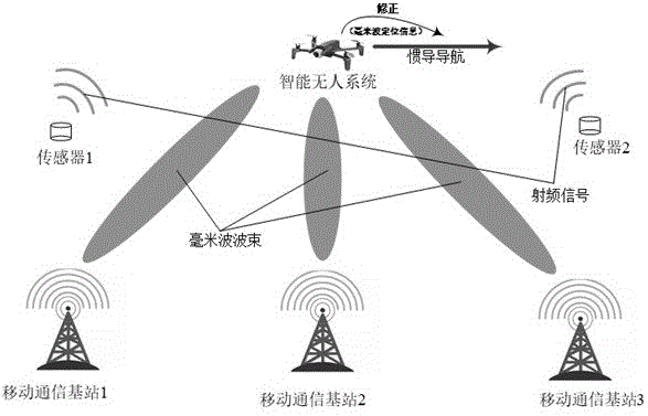
图1是本发明基于毫米波通感一体化无人设备的自主导航方法的场景示意图;Fig. 1 is a schematic diagram of the scene of the autonomous navigation method of the present invention based on millimeter wave synaesthesia integrated unmanned equipment;
图2是本发明自主导航系统中智能无人系统的结构框图;Fig. 2 is the structural block diagram of intelligent unmanned system in autonomous navigation system of the present invention;
图3是本发明自主导航系统中移动通信基站的结构框图。Fig. 3 is a structural block diagram of the mobile communication base station in the autonomous navigation system of the present invention.
具体实施方式Detailed ways
下面结合附图和具体实施方式,进一步阐明本发明,应理解下述具体实施方式仅用于说明本发明而不用于限制本发明的范围。The present invention will be further explained below in conjunction with the accompanying drawings and specific embodiments. It should be understood that the following specific embodiments are only used to illustrate the present invention and are not intended to limit the scope of the present invention.
实施例1Example 1
基于毫米波通感一体化无人设备的自主导航系统,包括一个或多个智能无人系统和一个或多个移动通信基站,其中,移动通信基站由射频通信发射天线、通信信号处理系统和射频通信接收天线组成,具体如图3所示。射频通信发射天线连接到通信信号处理系统,通信信号处理系统连接到射频通信接收天线,通信信号处理系统还连接到网关。移动通信基站面向所有用户发送信号,而非仅面向智能无人系统服务的,信号包括但不限于毫米波信号,因而智能无人系统只是利用了环境中的毫米波信号,进行定位和自主导航。The autonomous navigation system based on millimeter-wave synesthesia integrated unmanned equipment includes one or more intelligent unmanned systems and one or more mobile communication base stations, where the mobile communication base station consists of a radio frequency communication transmitting antenna, a communication signal processing system and a radio frequency The composition of the communication receiving antenna is shown in Figure 3. The radio frequency communication transmitting antenna is connected to the communication signal processing system, the communication signal processing system is connected to the radio frequency communication receiving antenna, and the communication signal processing system is also connected to the gateway. Mobile communication base stations send signals to all users, not only to intelligent unmanned system services. The signals include but are not limited to millimeter wave signals, so the intelligent unmanned system only uses the millimeter wave signals in the environment for positioning and autonomous navigation.
所述智能无人系统包括无人设备、动力系统、毫米波感知系统和惯导定位系统,如图2所示,智能无人系统可以是无人机、无人车、智能机器人等一系列无人系统,动力系统用于为智能无人系统提供动力支持,包括电机、电池、功放模块及移动控制模块,无人设备与电机相连接,电池分别与电机和功放模块相连接,功放模块与移动控制模块相连接。毫米波感知系统用于接收和处理移动通信基站的毫米波信号,并反馈导航校正,包括毫米波信号接收模块、毫米波信号处理模块及导航校正模块,所述毫米波信号处理模块分别与毫米波信号接收模块和导航校正模块相连接。惯导定位系统包括惯导导航模块、惯导信息处理模块及惯导定位模块,所述惯导信息处理模块分别与惯导导航模块和惯导定位模块相连接,惯导导航模块还分别与移动控制模块和导航校正模块相连接。The intelligent unmanned system includes unmanned equipment, power system, millimeter wave perception system and inertial navigation positioning system. The human system and the power system are used to provide power support for the intelligent unmanned system, including motors, batteries, power amplifier modules and mobile control modules. The unmanned equipment is connected to the motor, the battery is connected to the motor and the power amplifier module, and the power amplifier module is connected to the mobile connected to the control module. The millimeter wave sensing system is used to receive and process the millimeter wave signal of the mobile communication base station, and feed back the navigation correction, including the millimeter wave signal receiving module, the millimeter wave signal processing module and the navigation correction module, and the millimeter wave signal processing module is respectively connected with the millimeter wave The signal receiving module is connected with the navigation correction module. The inertial navigation system includes an inertial navigation module, an inertial navigation information processing module and an inertial navigation positioning module. The inertial navigation information processing module is connected to the inertial navigation module and the inertial positioning module respectively. The control module is connected with the navigation correction module.
智能无人系统实时接收来自移动通信基站的毫米波信号,解码信号帧头中基站身份信息和位置信息的同时,根据信号的出射角、到达角和到达时延,估计出智能无人系统与基站间的相对位置,依据此位置,对自身惯导定位系统的累积误差进行校正,并且根据惯导定位和毫米波定位,确定自身位置,实现自主导航。The intelligent unmanned system receives the millimeter wave signal from the mobile communication base station in real time, decodes the identity information and location information of the base station in the signal frame header, and estimates the distance between the intelligent unmanned system and the base station according to the outgoing angle, arrival angle and arrival delay of the signal. Based on this position, the cumulative error of its own inertial navigation positioning system is corrected, and according to the inertial navigation positioning and millimeter wave positioning, its own position is determined to realize autonomous navigation.
惯导定位系统存在累积误差e(t),因而可以为累积误差e(t)设定阙值,当e(t)达到阈值后,智能无人系统会偏离原有路线,到达错误的地点,因而此时可设定智能无人系统停止运行,以防止更加偏离路线,所述e(t)与时间呈正相关。There is a cumulative error e(t) in the inertial navigation positioning system, so a threshold can be set for the cumulative error e(t). When e(t) reaches the threshold, the intelligent unmanned system will deviate from the original route and arrive at the wrong place. Therefore, the intelligent unmanned system can be set to stop running at this time to prevent further deviation from the route, and the e(t) is positively correlated with time.
本实施例的自主导航系统可以实现智能无人系统的自主导航,而不需要人为的遥控和路线修正,同时,基于现有的移动通信系统,不需要搭建额外的通信链路且不影响现有通信系统,成本低、可实现性和可靠性高,使智能无人系统精准高速地到达目的地,解决了现有技术中无人系统实时高精度定位尚有缺陷的问题,实用性强,是未来新兴的自主导航产品。The autonomous navigation system of this embodiment can realize the autonomous navigation of the intelligent unmanned system without artificial remote control and route correction. At the same time, based on the existing mobile communication system, no additional communication links need to be built and the existing The communication system has low cost, high feasibility and high reliability, enables the intelligent unmanned system to reach the destination accurately and at high speed, solves the problem of real-time high-precision positioning of the unmanned system in the prior art, and has strong practicability. Emerging autonomous navigation products in the future.
实施例2Example 2
基于毫米波通感一体化无人设备的自主导航方法,如图1所示,包括如下步骤:The autonomous navigation method based on millimeter wave synesthesia integrated unmanned equipment, as shown in Figure 1, includes the following steps:
步骤S1:智能无人系统从初始点出发,初始点坐标已知。智能无人系统依靠的自身惯导定位系统,通过监测和计算智能无人系统在移动中的行进方向、速率和姿态等信息,与初始点位置相比对,从而实现智能无人系统初步的定位和导航。Step S1: The intelligent unmanned system starts from the initial point, and the coordinates of the initial point are known. The intelligent unmanned system relies on its own inertial navigation positioning system. By monitoring and calculating the moving direction, speed and attitude of the intelligent unmanned system, it compares it with the initial point position, so as to realize the preliminary positioning of the intelligent unmanned system. and navigation.
该惯导定位系统存在累积误差e(t),对累积误差e(t)设定阙值,e(t)与时间呈正相关,当e(t)达到一定阈值后,智能无人系统会偏离原有路线,从而到达错误的地点。The inertial navigation positioning system has a cumulative error e(t), and a threshold value is set for the cumulative error e(t), and e(t) is positively correlated with time. When e(t) reaches a certain threshold, the intelligent unmanned system will deviate from The original route, thus arriving at the wrong place.
步骤S2:智能无人系统收集自由空间中的毫米波信号,并对信号进行解码,获取信号帧头中的基站身份信息和位置信息,同时对来自不同基站的信号解码信息进行分类和存储,以进行下一步的处理。Step S2: The intelligent unmanned system collects millimeter wave signals in free space, decodes the signals, obtains the base station identity information and location information in the signal frame header, and classifies and stores the signal decoding information from different base stations at the same time to Proceed to the next step.
步骤S3:对一段时间内来自同一基站的信号信息进行处理,提取出信道状态信息(CSI),然后利用射频定位算法,从CSI中提取出毫米波信号的出射角、到达角和时延等信息,从而估计出基站相对于智能无人系统的方位等。Step S3: Process the signal information from the same base station for a period of time, extract the channel state information (CSI), and then use the radio frequency positioning algorithm to extract information such as the exit angle, arrival angle and delay of the millimeter wave signal from the CSI , so as to estimate the orientation of the base station relative to the intelligent unmanned system.
在实际系统中,我们可以根据状况的不同,选择不同的射频定位算法。本实施例中,通过MUSIC射频定位算法,从CSI中提取出到达角(AoA)等信息的算法步骤示例如下:In an actual system, we can choose different radio frequency positioning algorithms according to different conditions. In this embodiment, an example of algorithm steps for extracting information such as angle of arrival (AoA) from CSI through the MUSIC radio frequency positioning algorithm is as follows:
1、计算不同时域的多个接收信号向量的协方差矩阵;1. Calculate the covariance matrix of multiple received signal vectors in different time domains;
2、对协方差矩阵进行特征值分解;2. Perform eigenvalue decomposition on the covariance matrix;
3、按特征值的大小顺序,把与信号个数相等的最大特征值对应的特征向量看成信号子空间,把剩下的特征值对应的特征向量看成噪声子空间;3. According to the order of the size of the eigenvalues, the eigenvector corresponding to the largest eigenvalue equal to the number of signals is regarded as the signal subspace, and the eigenvectors corresponding to the remaining eigenvalues are regarded as the noise subspace;
4、计算谱函数,通过寻求峰值来得到到达角的估计值。对信号AoA进行遍历搜索时,当搜索到的角度与某个信号的AoA相同时,空间谱函数就会得到一个极值点,依据极值点,我们可以获取信号的AoA。4. Calculate the spectral function, and obtain the estimated value of the arrival angle by seeking the peak value. When performing a traversal search on the signal AoA, when the searched angle is the same as the AoA of a certain signal, the spatial spectrum function will get an extreme point. According to the extreme point, we can obtain the AoA of the signal.
假设接收端有M根天线,接收信号为X,则接收信号的相关矩阵可以被表示为

其中


由于协方差矩阵是厄尔米特矩阵, 所以矩阵的特征值均为实数, 并且由于协方差矩阵的特征值均大于 0 , 即矩阵是正定的,所以可推出


由于信号空间与噪声空间是正交的, 因此信号空间方向矩阵A的列向量与噪声空间的特征向量


其中


步骤S4:综合分析惯导定位系统和毫米波感知系统获取到的定位信息,估计出当前智能无人系统的准确位置,然后由毫米波感知系统中的导航校正模块,对智能无人系统的惯导导航模块进行误差校正。综合分析惯导定位系统和毫米波感知系统获取到的定位信息,估计出当前智能无人系统的准确位置,其原因在于毫米波定位也存在一定的误差,根据信道状况的不同,其误差也不同。智能无人系统需要根据实际情况,推算出惯导定位系统的定位置信区间和毫米波感知系统的定位置信区间,并联合分析得到一个更加精确的定位结果,作为惯导导航模块的修正依据。Step S4: Comprehensively analyze the positioning information obtained by the inertial navigation positioning system and the millimeter wave sensing system, estimate the accurate position of the current intelligent unmanned system, and then use the navigation correction module in the millimeter wave sensing system to calculate the inertial position of the intelligent unmanned system. The navigation module performs error correction. Comprehensively analyze the positioning information obtained by the inertial navigation positioning system and the millimeter wave sensing system, and estimate the accurate position of the current intelligent unmanned system. . The intelligent unmanned system needs to calculate the positioning confidence interval of the inertial navigation positioning system and the positioning confidence interval of the millimeter wave sensing system according to the actual situation, and jointly analyze to obtain a more accurate positioning result, which is used as the correction basis of the inertial navigation module.
除了移动通信基站外,智能无人系统也可以接收环境中的传感器广播的信息,根据传感器的身份信息、所在位置,射频信号的方向和时延,估测自身所在位置。In addition to the mobile communication base station, the intelligent unmanned system can also receive information broadcast by sensors in the environment, and estimate its own location based on the sensor's identity information, location, direction and time delay of the radio frequency signal.
步骤S5:根据惯导定位和毫米波定位,确定自身位置,实现自主导航。Step S5: According to inertial navigation positioning and millimeter wave positioning, determine its own position and realize autonomous navigation.
假设无人系统初始位置为


其中 

在毫米波定位系统中,根据步骤s3中的算法,我们可以得到基站信号的到达角。假设有N个基站,则对应有N个信号的到达角。由于基站位置固定,结合基站所在位置,基站信号方向连线的交点位置,即为无人系统所在位置 

根据惯导系统和基站所得出的无人系统位置 


需要说明的是,以上内容仅仅说明了本发明的技术思想,不能以此限定本发明的保护范围,对于本技术领域的普通技术人员来说,在不脱离本发明原理的前提下,还可以做出若干改进和润饰,这些改进和润饰均落入本发明权利要求书的保护范围之内。It should be noted that the above content only illustrates the technical idea of the present invention, and cannot limit the scope of protection of the present invention. For those of ordinary skill in the art, without departing from the principle of the present invention, they can also do Several improvements and modifications are made, and these improvements and modifications all fall within the protection scope of the claims of the present invention.
Claims (10)


Priority Applications (2)
| Application Number | Priority Date | Filing Date | Title |
|---|---|---|---|
| CN202211279327.8A CN115355907A (en) | 2022-10-19 | 2022-10-19 | Autonomous navigation system and method based on millimeter wave sensing integrated unmanned equipment |
| PCT/CN2023/072868 WO2024082475A1 (en) | 2022-10-19 | 2023-01-18 | Autonomous navigation system and method based on millimeter-wave integrated sensing and communication unmanned device |
Applications Claiming Priority (1)
| Application Number | Priority Date | Filing Date | Title |
|---|---|---|---|
| CN202211279327.8A CN115355907A (en) | 2022-10-19 | 2022-10-19 | Autonomous navigation system and method based on millimeter wave sensing integrated unmanned equipment |
Publications (1)
| Publication Number | Publication Date |
|---|---|
| CN115355907A true CN115355907A (en) | 2022-11-18 |
Family
ID=84009014
Family Applications (1)
| Application Number | Title | Priority Date | Filing Date |
|---|---|---|---|
| CN202211279327.8A Pending CN115355907A (en) | 2022-10-19 | 2022-10-19 | Autonomous navigation system and method based on millimeter wave sensing integrated unmanned equipment |
Country Status (2)
| Country | Link |
|---|---|
| CN (1) | CN115355907A (en) |
| WO (1) | WO2024082475A1 (en) |
Cited By (1)
| Publication number | Priority date | Publication date | Assignee | Title |
|---|---|---|---|---|
| WO2024082475A1 (en) * | 2022-10-19 | 2024-04-25 | 东南大学 | Autonomous navigation system and method based on millimeter-wave integrated sensing and communication unmanned device |
Citations (10)
| Publication number | Priority date | Publication date | Assignee | Title |
|---|---|---|---|---|
| CN103209383A (en) * | 2013-03-14 | 2013-07-17 | 上海逻迅信息科技有限公司 | Information system based on Internet of Things |
| CN104132666A (en) * | 2014-07-16 | 2014-11-05 | 北京邮电大学 | Variable importance degree-based vehicle real time positioning method |
| CN106546951A (en) * | 2016-10-31 | 2017-03-29 | 中国农业大学 | A kind of integrated navigation system and method for Stichopus japonicuss dredger |
| CN109341679A (en) * | 2018-09-30 | 2019-02-15 | 华中科技大学 | A kind of intelligent device navigation method and navigation system |
| CN110275194A (en) * | 2018-03-14 | 2019-09-24 | 北京嘀嘀无限科技发展有限公司 | Method and system for correcting vehicle trajectory |
| CN111148021A (en) * | 2019-12-30 | 2020-05-12 | 青岛科技大学 | Millimeter wave single base station positioning method based on switched beam forming |
| CN111157984A (en) * | 2020-01-08 | 2020-05-15 | 电子科技大学 | A Pedestrian Autonomous Navigation Method Based on Millimeter Wave Radar and Inertial Measurement Unit |
| US20210318125A1 (en) * | 2018-06-11 | 2021-10-14 | King Abdullah University Of Science And Technology | Millimeter-wave radar-based autonomous navigation system |
| CN113758482A (en) * | 2020-06-05 | 2021-12-07 | 深圳澳谷智能科技有限公司 | Vehicle navigation and positioning method, device, base station, system and readable storage medium |
| CN114928518A (en) * | 2022-05-18 | 2022-08-19 | 东南大学 | Channel estimation method based on 3D-MUSIC algorithm in millimeter wave MIMO-OFDM system |
Family Cites Families (13)
| Publication number | Priority date | Publication date | Assignee | Title |
|---|---|---|---|---|
| KR20010111982A (en) * | 2000-06-14 | 2001-12-20 | 서평원 | Method and apparatus for tracking position |
| GB2476990A (en) * | 2010-01-19 | 2011-07-20 | Thales Holdings Uk Plc | On-board unit for determining the route taken by a vehicle without the use of a global navigation satellite system for positioning |
| US11175375B2 (en) * | 2010-11-12 | 2021-11-16 | Position Imaging, Inc. | Position tracking system and method using radio signals and inertial sensing |
| US10416276B2 (en) * | 2010-11-12 | 2019-09-17 | Position Imaging, Inc. | Position tracking system and method using radio signals and inertial sensing |
| CN103209388A (en) * | 2013-04-12 | 2013-07-17 | 浙江大学 | Method and system for hybrid positioning on basis of multi-mode signals |
| US10928834B2 (en) * | 2018-05-14 | 2021-02-23 | Ford Global Technologies, Llc | Autonomous vehicle localization using 5G infrastructure |
| CN114143705B (en) * | 2020-09-02 | 2024-03-26 | 蓝色创源(北京)科技有限公司 | Direction finding method, device, system and storage medium |
| CN112034419B (en) * | 2020-09-08 | 2024-02-06 | 北京邮电大学 | Propagation delay estimation method and device for 5G positioning |
| WO2022088018A1 (en) * | 2020-10-30 | 2022-05-05 | 网络通信与安全紫金山实验室 | Positioning method, apparatus, device and system, and storage medium |
| CN112887899B (en) * | 2021-01-06 | 2022-03-11 | 清华大学 | A positioning system and positioning method based on single base station soft location information |
| CN113382355B (en) * | 2021-06-08 | 2022-07-12 | 上海航天测控通信研究所 | Direction-finding positioning system and positioning method based on arrival angle estimation |
| CN114114150B (en) * | 2021-11-26 | 2025-11-07 | 东南大学 | Communication perception integration-oriented wireless positioning method |
| CN115355907A (en) * | 2022-10-19 | 2022-11-18 | 东南大学 | Autonomous navigation system and method based on millimeter wave sensing integrated unmanned equipment |
-
2022
- 2022-10-19 CN CN202211279327.8A patent/CN115355907A/en active Pending
-
2023
- 2023-01-18 WO PCT/CN2023/072868 patent/WO2024082475A1/en not_active Ceased
Patent Citations (10)
| Publication number | Priority date | Publication date | Assignee | Title |
|---|---|---|---|---|
| CN103209383A (en) * | 2013-03-14 | 2013-07-17 | 上海逻迅信息科技有限公司 | Information system based on Internet of Things |
| CN104132666A (en) * | 2014-07-16 | 2014-11-05 | 北京邮电大学 | Variable importance degree-based vehicle real time positioning method |
| CN106546951A (en) * | 2016-10-31 | 2017-03-29 | 中国农业大学 | A kind of integrated navigation system and method for Stichopus japonicuss dredger |
| CN110275194A (en) * | 2018-03-14 | 2019-09-24 | 北京嘀嘀无限科技发展有限公司 | Method and system for correcting vehicle trajectory |
| US20210318125A1 (en) * | 2018-06-11 | 2021-10-14 | King Abdullah University Of Science And Technology | Millimeter-wave radar-based autonomous navigation system |
| CN109341679A (en) * | 2018-09-30 | 2019-02-15 | 华中科技大学 | A kind of intelligent device navigation method and navigation system |
| CN111148021A (en) * | 2019-12-30 | 2020-05-12 | 青岛科技大学 | Millimeter wave single base station positioning method based on switched beam forming |
| CN111157984A (en) * | 2020-01-08 | 2020-05-15 | 电子科技大学 | A Pedestrian Autonomous Navigation Method Based on Millimeter Wave Radar and Inertial Measurement Unit |
| CN113758482A (en) * | 2020-06-05 | 2021-12-07 | 深圳澳谷智能科技有限公司 | Vehicle navigation and positioning method, device, base station, system and readable storage medium |
| CN114928518A (en) * | 2022-05-18 | 2022-08-19 | 东南大学 | Channel estimation method based on 3D-MUSIC algorithm in millimeter wave MIMO-OFDM system |
Non-Patent Citations (3)
| Title |
|---|
| HAO JIANG: "A Novel Estimated Wideband Geometry-Based", 《IEEE》 * |
| 曾庆化等: "基于UWB优化配置的室内行人导航方法", 《中国惯性技术学报》 * |
| 王淑芬等: "巡航导弹自主导航", 《飞航导弹》 * |
Cited By (1)
| Publication number | Priority date | Publication date | Assignee | Title |
|---|---|---|---|---|
| WO2024082475A1 (en) * | 2022-10-19 | 2024-04-25 | 东南大学 | Autonomous navigation system and method based on millimeter-wave integrated sensing and communication unmanned device |
Also Published As
| Publication number | Publication date |
|---|---|
| WO2024082475A1 (en) | 2024-04-25 |
Similar Documents
| Publication | Publication Date | Title |
|---|---|---|
| US20210287559A1 (en) | Device, system, and method for controlling unmanned aerial vehicle | |
| US20200275402A1 (en) | Methods and apparatuses using sensing system in cooperation with wireless communication system | |
| Mavromatis et al. | Beam alignment for millimetre wave links with motion prediction of autonomous vehicles | |
| EP3379282B1 (en) | Monitoring system and method for monitoring an unmanned aerial vehicle | |
| CN106452541B (en) | A beamforming method and device for mutual assistance of optical and wireless signals | |
| CN101442823A (en) | Method for locating WSN distributed node based on wave arrive direction estimation | |
| WO2017061429A1 (en) | Antenna directivity control signal generation device, wireless communication device, wireless communication control system, and method and program for controlling antenna directivity | |
| CN105554842B (en) | A kind of method for searching and hunting system of more mobile relay optimal communications position | |
| JP2016171458A (en) | Tracking antenna system and tracking antenna device | |
| CN108196290A (en) | A kind of unmanned aerial vehicle group carries polarized array attitude measurement and object detection method | |
| WO2025001419A1 (en) | Integrated sensing and communication cooperative transmission method based on space-time block coding ofdm signal | |
| Tripathi et al. | A socially-aware radio map framework for improving QoS of UAV-assisted MEC networks | |
| JP7156464B2 (en) | Vehicles and Programs | |
| CN116471608B (en) | A method and device for sensing-assisted multi-user beam management | |
| CN115355907A (en) | Autonomous navigation system and method based on millimeter wave sensing integrated unmanned equipment | |
| Yanpeng et al. | Sensing-assisted accurate and fast beam management for cellular-connected mmWave UAV network | |
| CN111398894A (en) | Low-slow small target detection tracking system and method based on mobile communication network | |
| Tasaki et al. | 3D convolutional neural network-aided indoor positioning based on fingerprints of BLE RSSI | |
| CN111372195B (en) | Method, apparatus and storage medium for tracking position of mobile terminal in mobile communication network | |
| Afifi et al. | Unmanned aerial vehicles 3-D autonomous outdoor localization: A deep learning approach | |
| KR102637482B1 (en) | Beam management method for vehicle-to-vehicle communication using a multi-antenna array based on position and speed awareness | |
| EP4672788A1 (en) | POSITIONING METHOD, COMMUNICATION DEVICE AND STORAGE MEDIUM | |
| Prabhath et al. | Optimal adaptation of 3D beamformers in UAV networks | |
| Cabrera et al. | Data collection using unmanned aerial vehicles and a delay-tolerant network | |
| Agliamzanov et al. | Robust and efficient self-adaptive position tracking in wireless embedded systems |
Legal Events
| Date | Code | Title | Description |
|---|---|---|---|
| PB01 | Publication | ||
| PB01 | Publication | ||
| SE01 | Entry into force of request for substantive examination | ||
| SE01 | Entry into force of request for substantive examination |