CN112640417B - Matching relation determining method and related device - Google Patents
Matching relation determining method and related device Download PDFInfo
- Publication number
- CN112640417B CN112640417B CN201980051525.9A CN201980051525A CN112640417B CN 112640417 B CN112640417 B CN 112640417B CN 201980051525 A CN201980051525 A CN 201980051525A CN 112640417 B CN112640417 B CN 112640417B
- Authority
- CN
- China
- Prior art keywords
- image
- feature point
- feature
- target
- point
- Prior art date
- Legal status (The legal status is an assumption and is not a legal conclusion. Google has not performed a legal analysis and makes no representation as to the accuracy of the status listed.)
- Active
Links
Images


Classifications
-
- H—ELECTRICITY
- H04—ELECTRIC COMMUNICATION TECHNIQUE
- H04N—PICTORIAL COMMUNICATION, e.g. TELEVISION
- H04N23/00—Cameras or camera modules comprising electronic image sensors; Control thereof
- H04N23/60—Control of cameras or camera modules
Landscapes
- Engineering & Computer Science (AREA)
- Multimedia (AREA)
- Signal Processing (AREA)
- Traffic Control Systems (AREA)
Abstract
一种匹配关系确定方法、重投影误差计算方法及相关装置,涉及人工智能领域,具体涉及自动驾驶领域,该匹配关系确定方法包括:获取N组特征点对(301),每组特征点对包括两个相匹配的特征点,其中一个特征点为从第一图像提取的特征点,另一个特征点为从第二图像提取的特征点;利用动态障碍物的运动状态信息对所述N组特征点对中目标特征点的像素坐标进行调整(302),所述目标特征点属于所述第一图像和/或所述第二图像中所述动态障碍物对应的特征点;根据所述N组特征点对中各特征点对应的调整后的像素坐标,确定所述第一图像和所述第二图像之间的目标匹配关系(303);在存在动态障碍物的自动驾驶场景能准确地确定两帧图像之间的匹配关系。

A method for determining a matching relationship, a method for calculating a reprojection error, and a related device, relating to the field of artificial intelligence, in particular to the field of automatic driving. The method for determining a matching relationship includes: acquiring N groups of feature point pairs (301), and each group of feature point pairs includes Two matching feature points, one of which is the feature point extracted from the first image, and the other feature point is the feature point extracted from the second image; the N groups of features are analyzed by using the motion state information of the dynamic obstacles. Adjusting the pixel coordinates of the target feature point in the point pairing (302), the target feature point belongs to the feature point corresponding to the dynamic obstacle in the first image and/or the second image; according to the N groups The adjusted pixel coordinates corresponding to each feature point in the feature point pair, and the target matching relationship between the first image and the second image is determined (303); in an automatic driving scene with dynamic obstacles, it can be accurately determined The matching relationship between two frames of images.
Description
技术领域technical field
本申请涉及人工智能领域的自动驾驶领域,尤其涉及一种匹配关系确定方法、重投影误差计算方法及相关装置。The present application relates to the field of automatic driving in the field of artificial intelligence, and in particular, to a method for determining a matching relationship, a method for calculating a reprojection error, and a related device.
背景技术Background technique
人工智能(Artificial Intelligence,AI)是利用数字计算机或者数字计算机控制的机器模拟、延伸和扩展人的智能,感知环境、获取知识并使用知识获得最佳结果的理论、方法、技术及应用系统。自动驾驶是人工智能领域的一种主流应用,自动驾驶技术依靠计算机视觉、雷达、监控装置和全球定位系统等协同合作,让机动车辆可以在不需要人类主动操作下,实现自动驾驶。自动驾驶的车辆使用各种计算系统来帮助将乘客从一个位置运输到另一位置。由于自动驾驶技术无需人类来驾驶机动车辆,所以理论上能够有效避免人类的驾驶失误,减少交通事故的发生,且能够提高公路的运输效率。因此,自动驾驶技术越来越受到重视。Artificial intelligence (AI) is a theory, method, technology and application system that uses digital computers or machines controlled by digital computers to simulate, extend and expand human intelligence, perceive the environment, acquire knowledge and use knowledge to obtain the best results. Autopilot is a mainstream application in the field of artificial intelligence. Autopilot technology relies on the cooperation of computer vision, radar, monitoring devices and global positioning systems to allow motor vehicles to achieve autonomous driving without the need for human active operation. Autonomous vehicles use various computing systems to help transport passengers from one location to another. Since automatic driving technology does not require humans to drive motor vehicles, it can theoretically effectively avoid human driving errors, reduce the occurrence of traffic accidents, and improve the efficiency of highway transportation. Therefore, autonomous driving technology is getting more and more attention.
目前,自动驾驶装置采用即时定位与地图构建(Simultaneous Localization AndMapping, SLAM)等定位方法进行定位时,通常以其采集到的各帧图像的重投影误差为量测量。也就是说,自动驾驶装置在采用SLAM进行定位时,需要计算其采集到的各帧图像的重投影误差。一帧图像的重投影误差是指投影的点与该帧图像上的测量点之间的误差,投影的点可以是该帧图像中的各特征点对应的三维空间坐标投影至该帧图像的坐标点,测量点可以是这些特征点在该帧图像中的坐标点。当前普遍采用的一种计算重投影误差的方式如下:确定目标帧图像中各特征点对应的三维空间坐标,以得到第一三维空间坐标;计算该目标帧图像与参考帧图像之间的平移矩阵和旋转矩阵;利用该平移矩阵和旋转矩阵将该第一三维空间坐标中的各三维空间坐标转换至参考坐标系,以得到第二三维空间坐标;将该第二三维空间坐标中的各三维空间坐标投影至该目标帧图像以得到投影的点;计算投影的点与该目标帧图像中各特征点的坐标点(即测量点)之间的误差,以得到该目标帧图像的重投影误差。其中,该参考坐标系可以是自动驾驶装置在本次行驶的起始地点建立的世界坐标系,该参考帧图像可以是自动驾驶装置在该起始地点采集的第一帧图像,该目标帧图像可以是该自动驾驶装置在本次行驶过程中采集的除该参考帧图像之外的任一帧图像。自动驾驶装置为计算其采集的各帧图像与参考帧图像之间的关系需要计算其采集到的任意两帧相邻图像之间的匹配关系,进而计算得到其采集到的各帧图像与参考帧图像之间的匹配关系。目前,一般采用特征匹配的方式来确定两帧图像之间的匹配关系。At present, when an automatic driving device uses a localization method such as Simultaneous Localization And Mapping (SLAM) for localization, it is usually measured by the reprojection error of each frame of images collected. That is to say, when the automatic driving device uses SLAM for positioning, it needs to calculate the re-projection error of each frame image collected by it. The reprojection error of a frame of image refers to the error between the projected point and the measurement point on the frame image. The projected point can be the coordinates of the three-dimensional space coordinates corresponding to each feature point in the frame image projected to the frame image. The measurement points can be the coordinate points of these feature points in the frame image. A currently commonly used method for calculating the reprojection error is as follows: determine the three-dimensional space coordinates corresponding to each feature point in the target frame image to obtain the first three-dimensional space coordinate; calculate the translation matrix between the target frame image and the reference frame image and rotation matrix; use the translation matrix and rotation matrix to convert each three-dimensional space coordinate in the first three-dimensional space coordinate to the reference coordinate system to obtain the second three-dimensional space coordinate; each three-dimensional space coordinate in the second three-dimensional space coordinate The coordinates are projected to the target frame image to obtain the projected point; the error between the projected point and the coordinate points (ie measurement points) of each feature point in the target frame image is calculated to obtain the reprojection error of the target frame image. Wherein, the reference coordinate system may be the world coordinate system established by the automatic driving device at the starting point of the current driving, the reference frame image may be the first frame image collected by the automatic driving device at the starting point, the target frame image It may be any frame image except the reference frame image collected by the automatic driving device during the current driving process. In order to calculate the relationship between each frame of images collected by the automatic driving device and the reference frame image, it needs to calculate the matching relationship between any two adjacent frames collected by it, and then calculate each frame image collected by it and the reference frame. matching relationship between images. At present, feature matching is generally used to determine the matching relationship between two frames of images.
在特征匹配中,为了消除特征匹配中的误匹配,随机抽样一致性(RANdom SAmpleConsensus,RANSAC)被使用到特征匹配中。RANSAC算法的流程如下:假设样本(匹配两帧图像得到的多组特征点对)中包含内点(inliers)和外点(outliers),分别对应正确匹配点对和错误匹配点对,随机从样本中抽取4组点对,计算出两帧图像之间的匹配关系;然后根据该匹配关系,把剩余特征点对分成内点和外点,重复上述步骤,选取数量最多的内点所对应的匹配关系为最终的两帧图像之间的匹配关系。其中,两帧图像分别为自动驾驶装置在第一时刻和第二时刻采集的图像,该匹配关系是这两帧图像之间的平移矩阵和旋转矩阵。RANSAC算法的本质是一种少数服从多数的算法。当动态障碍物占据视野很大一部分的时候,比如,自动驾驶装置跟在一个很大的车后面行驶,外点(其他车辆等动态障碍物)会被算法当成内点,而内点(静态障碍物)被错误当成了外点剔除,这样就不能准确地确定两帧图像之间的匹配关系。可见,在一些存在动态障碍物的自动驾驶场景中,采用RANSAC算法有时候不能准确地确定两帧图像之间的匹配关系。因此,需要研究在存在动态障碍物的自动驾驶场景能准确地确定两帧图像之间的匹配关系的方案。In feature matching, in order to eliminate the false matching in feature matching, random sampling consensus (RANdom SAmple Consensus, RANSAC) is used in feature matching. The process of the RANSAC algorithm is as follows: Assume that the sample (multiple sets of feature point pairs obtained by matching two frames of images) contains inliers and outliers, corresponding to the correct matching point pair and the wrong matching point pair, and randomly select from the sample. Extract 4 sets of point pairs from , and calculate the matching relationship between the two frames of images; then, according to the matching relationship, the remaining feature point pairs are divided into inner points and outer points, and the above steps are repeated to select the matching corresponding to the largest number of inner points. The relationship is the matching relationship between the final two frames of images. The two frames of images are images collected by the automatic driving device at the first moment and the second moment respectively, and the matching relationship is the translation matrix and the rotation matrix between the two frames of images. The essence of the RANSAC algorithm is that the minority obeys the majority. When dynamic obstacles occupy a large part of the field of view, for example, the automatic driving device is driving behind a large car, the outer points (dynamic obstacles such as other vehicles) will be regarded by the algorithm as interior points, while the interior points (static obstacles) object) is mistakenly regarded as an outlier culling, so that the matching relationship between the two frames cannot be accurately determined. It can be seen that in some automatic driving scenarios with dynamic obstacles, the RANSAC algorithm sometimes cannot accurately determine the matching relationship between two frames of images. Therefore, it is necessary to study a scheme that can accurately determine the matching relationship between two frames of images in an automatic driving scene with dynamic obstacles.
发明内容SUMMARY OF THE INVENTION
本申请实施例提供了一种匹配关系确定方法、重投影误差计算方法及相关装置,在存在动态障碍物的自动驾驶场景能准确地确定两帧图像之间的匹配关系。The embodiments of the present application provide a method for determining a matching relationship, a method for calculating a reprojection error, and a related device, which can accurately determine the matching relationship between two frames of images in an automatic driving scene with dynamic obstacles.
第一方面,本申请实施例提供了一种匹配关系确定方法,该方法可包括:获取N组特征点对,每组特征点对包括两个相匹配的特征点,其中一个特征点为从第一图像提取的特征点,另一个特征点为从第二图像提取的特征点,该第一图像和该第二图像分别为自动驾驶装置在第一时刻和第二时刻采集的图像,N为大于1的整数;利用动态障碍物的运动状态信息对该N组特征点对中目标特征点的像素坐标进行调整,该目标特征点属于该第一图像和/或该第二图像中该动态障碍物对应的特征点,该N组特征点对中除该目标特征点之外的特征点的像素坐标保持不变;根据该N组特征点对中各特征点对应的调整后的像素坐标,确定该第一图像和该第二图像之间的目标匹配关系。In a first aspect, an embodiment of the present application provides a method for determining a matching relationship, the method may include: acquiring N groups of feature point pairs, each group of feature point pairs includes two matching feature points, one of which is from the first feature point. One feature point is extracted from an image, and the other feature point is a feature point extracted from a second image. The first image and the second image are images collected by the automatic driving device at the first moment and the second moment, respectively, and N is greater than An integer of 1; the pixel coordinates of the target feature point in the N groups of feature point pairs are adjusted using the motion state information of the dynamic obstacle, and the target feature point belongs to the dynamic obstacle in the first image and/or the second image The corresponding feature points, the pixel coordinates of the feature points other than the target feature point in the N groups of feature point pairs remain unchanged; according to the adjusted pixel coordinates corresponding to each feature point in the N groups of feature point pairs, determine the The target matching relationship between the first image and the second image.
该第一图像和该第二图像之间的匹配关系可以是该第一图像和该第二图像之间的平移矩阵和旋转矩阵。由于动态障碍物的运动状态与静态障碍物的运动状态不同,第一图像和第二图像中动态障碍物对应的特征点之间的平移矩阵和旋转矩阵,与该第一图像和该第二图像中静态障碍物对应的特征点之间的平移矩阵和旋转矩阵不同。可以理解,只有N组特征点对中的特征点均为静态障碍物对应的特征点时,根据该N组特征点对中各特征点对应的像素坐标才能较准确地确定第一图像和第二图像之间的匹配关系。本申请实施例中,利用动态障碍物的运动状态信息对N组特征点对中目标特征点对应的像素坐标进行调整之后,该N组特征点对中动态障碍物对应的特征点之间的平移矩阵和旋转矩阵与该N组特征点对中静态障碍物对应的特征点之间的平移矩阵和旋转矩阵基本相同,因此根据该N组特征点对中各特征点对应的像素坐标能够较准确地确定第一图像和第二图像之间的匹配关系。The matching relationship between the first image and the second image may be a translation matrix and a rotation matrix between the first image and the second image. Since the motion state of the dynamic obstacle is different from that of the static obstacle, the translation matrix and rotation matrix between the feature points corresponding to the dynamic obstacle in the first image and the second image are different from the first image and the second image. The translation matrices and rotation matrices between the feature points corresponding to the static obstacles are different. It can be understood that only when the feature points in the N groups of feature point pairs are all feature points corresponding to static obstacles, the first image and the second image can be more accurately determined according to the pixel coordinates corresponding to each feature point in the N groups of feature point pairs. matching relationship between images. In the embodiment of the present application, after adjusting the pixel coordinates corresponding to the target feature points in the N groups of feature point pairs by using the motion state information of the dynamic obstacles, the translation between the feature points corresponding to the dynamic obstacles in the N groups of feature point pairs The matrix and rotation matrix are basically the same as the translation matrix and rotation matrix between the feature points corresponding to the static obstacles in the N groups of feature point pairs, so according to the pixel coordinates corresponding to each feature point in the N groups of feature point pairs A matching relationship between the first image and the second image is determined.
在一个可选的实现方式中,运动状态信息包括该动态障碍物从该第一时刻至该第二时刻的位移;利用动态障碍物的运动状态信息对该N组特征点对中目标特征点的像素坐标进行调整包括:利用该位移对参考特征点的像素坐标进行调整,该参考特征点包含于该目标特征点,且属于该第二图像中该动态障碍物对应的特征点。In an optional implementation manner, the motion state information includes the displacement of the dynamic obstacle from the first moment to the second moment; the motion state information of the dynamic obstacle is used to pair the target feature points of the N groups of feature points. Adjusting the pixel coordinates includes: using the displacement to adjust the pixel coordinates of a reference feature point, the reference feature point being included in the target feature point and belonging to the feature point corresponding to the dynamic obstacle in the second image.
在该实现方式中,利用动态障碍物从第一时刻至第二时刻的位移对参考特征点的像素坐标进行调整(即运动补偿),使得该参考特征点的像素坐标被调整后基本等同于静态障碍物的像素坐标,以便于更准确地确定第一图像和第二图像之间的匹配关系。In this implementation, the pixel coordinates of the reference feature point are adjusted (ie, motion compensation) by using the displacement of the dynamic obstacle from the first moment to the second moment, so that the pixel coordinates of the reference feature point are basically equivalent to static The pixel coordinates of the obstacle in order to more accurately determine the matching relationship between the first image and the second image.
在一个可选的实现方式中,在利用动态障碍物的运动状态信息对该N组特征点对中目标特征点的像素坐标进行调整之前,该方法还包括:确定该N组特征点对中位于第一投影区域和/或第二投影区域的特征点为该目标特征点;该第一投影区域为该第一图像中该动态障碍物的图像所处的区域,该第二投影区域为该第二图像中该动态障碍物的图像所处的区域;获得该目标特征点对应的像素坐标。In an optional implementation manner, before adjusting the pixel coordinates of the target feature point in the N groups of feature point pairs by using the motion state information of the dynamic obstacle, the method further includes: determining that the N groups of feature point pairs are located in the center The feature points of the first projection area and/or the second projection area are the target feature points; the first projection area is the area where the image of the dynamic obstacle in the first image is located, and the second projection area is the first projection area. The area where the image of the dynamic obstacle is located in the second image; obtain the pixel coordinates corresponding to the target feature point.
在该实现方式中,根据第一图像和第二图像中动态障碍物的图像所处的区域,可以快速、准确地确定N组特征点对中的目标特征点。In this implementation manner, the target feature points in the N groups of feature point pairs can be quickly and accurately determined according to the regions where the images of the dynamic obstacles are located in the first image and the second image.
在一个可选的实现方式中,在确定该N组特征点对中位于第一投影区域和/或第二投影区域的特征点为该目标特征点之前,该方法还包括:获得目标点云,该目标点云为表征该动态障碍物在该第一时刻的特性的点云;将该目标点云投影到该第一图像以得到该第一投影区域。In an optional implementation manner, before determining that the feature point located in the first projection area and/or the second projection area in the N groups of feature point pairs is the target feature point, the method further includes: obtaining a target point cloud, The target point cloud is a point cloud representing the characteristics of the dynamic obstacle at the first moment; the target point cloud is projected onto the first image to obtain the first projection area.
在该实现方式中,将动态障碍物在第一时刻的特性的点云投影至第一图像,可以准确地确定该第一图像中动态障碍物所处的区域。In this implementation manner, the point cloud of the characteristics of the dynamic obstacle at the first moment is projected to the first image, so that the region where the dynamic obstacle is located in the first image can be accurately determined.
在一个可选的实现方式中,在确定该N组特征点对中位于第一投影区域和/或第二投影区域的特征点为该目标特征点之前,该方法还包括:对第一点云和第二点云进行插值计算以得到目标点云,该第一点云和该第二点云分别为该自动驾驶装置在第三时刻和第四时刻采集的点云,该目标点云为表征该动态障碍物在该第一时刻的特性的点云,该第三时刻在该第一时刻之前,该第四时刻在该第一时刻之后;将该目标点云投影到该第一图像以得到该第一投影区域。In an optional implementation manner, before determining that the feature point located in the first projection area and/or the second projection area in the N groups of feature point pairs is the target feature point, the method further includes: analyzing the first point cloud Perform interpolation calculation with the second point cloud to obtain the target point cloud, the first point cloud and the second point cloud are the point clouds collected by the automatic driving device at the third moment and the fourth moment respectively, and the target point cloud is a representative The point cloud of the characteristics of the dynamic obstacle at the first moment, the third moment is before the first moment, and the fourth moment is after the first moment; project the target point cloud to the first image to obtain the first projection area.
在该实现方式中,通过插值计算的方式得到目标点云,可以较准确地确定任一时刻的点云。In this implementation, the target point cloud is obtained by means of interpolation calculation, and the point cloud at any moment can be determined more accurately.
在一个可选的实现方式中,该目标匹配关系为采用随机抽样一致性RANSAC算法确定的该第一图像和该第二图像之间的两个或两个以上匹配关系中较优的匹配关系。In an optional implementation manner, the target matching relationship is a better matching relationship among two or more matching relationships between the first image and the second image determined by using a random sampling consistency RANSAC algorithm.
该N组特征点对可以为从第一图像和第二图像相匹配的多组特征点对中随机获取的N 组特征点对。使用该N组特征点对调整后的像素坐标确定的匹配关系,可能不是该第一图像和该第二图像之间最优的匹配关系。为更准确地确定第一图像和第二图像之间的匹配关系,可以采用RANSAC算法来从第一图像和第二图像之间的多个匹配关系中确定一个较优的匹配关系。可选的,在该第一图像和该第二图像之间的匹配关系之后,则重新随机从第一图像和第二图像相匹配的多组特征点对中获取N组特征点对,根据新获取的获取N组特征点对,再次确定该第一图像和该第二图像之间的匹配关系,直到得到较优的匹配关系。采用随机抽样一致性RANSAC算法确定该目标匹配关系为该第一图像和该第二图像之间的两个或两个以上匹配关系中较优的匹配关系可以是:将第一图像和第二图像相匹配的多组特征点对代入至该目标匹配关系可得到最多的内点,且内点的个数大于数量阈值。该数量阈值可以是该多组特征点对的个数的百分之八十、百分之九十等。在该实现方式中,采用RANSAC算法可以更准确地确定该第一图像和该第二图像之间的匹配关系。The N groups of feature point pairs may be N groups of feature point pairs randomly obtained from multiple groups of feature point pairs matching the first image and the second image. The matching relationship determined by using the N groups of feature points to the adjusted pixel coordinates may not be the optimal matching relationship between the first image and the second image. In order to more accurately determine the matching relationship between the first image and the second image, a RANSAC algorithm may be used to determine a better matching relationship from multiple matching relationships between the first image and the second image. Optionally, after the matching relationship between the first image and the second image, N groups of feature point pairs are randomly obtained from the multiple sets of feature point pairs that match the first image and the second image, and according to the new The acquired N groups of feature point pairs are obtained, and the matching relationship between the first image and the second image is determined again until a better matching relationship is obtained. Using the random sampling consistency RANSAC algorithm to determine that the target matching relationship is a better matching relationship among two or more matching relationships between the first image and the second image may be: combining the first image and the second image The matching multiple sets of feature point pairs are substituted into the target matching relationship to obtain the most inliers, and the number of inliers is greater than the number threshold. The number threshold may be 80%, 90%, etc. of the number of the sets of feature point pairs. In this implementation manner, using the RANSAC algorithm can more accurately determine the matching relationship between the first image and the second image.
在一个可选的实现方式中,根据该N组特征点对中各特征点对应的调整后的像素坐标,确定该第一图像和该第二图像之间的目标匹配关系包括:根据该N组特征点对中各特征点对应的调整后的像素坐标,确定该第一图像和该第二图像之间的平移矩阵和旋转矩阵。In an optional implementation manner, determining the target matching relationship between the first image and the second image according to the adjusted pixel coordinates corresponding to each feature point in the N groups of feature point pairs includes: according to the N groups of feature points The adjusted pixel coordinates corresponding to each feature point in the feature point pair determine the translation matrix and the rotation matrix between the first image and the second image.
第二方面,本申请实施例提供了一种重投影误差计算方法,该方法可包括:利用动态障碍物的运动状态信息对第一空间坐标中第一特征点对应的空间坐标进行调整以得到第二空间坐标,该第一空间坐标包括第一图像中各特征点对应的空间坐标,该第一特征点为该第一图像中该动态障碍物对应的特征点,该第一图像为自动驾驶装置在第二时刻采集的图像,该运动状态信息包括该自动驾驶装置从第一时刻至该第二时刻的位移和姿态变化;将该第二空间坐标投影至该第一图像以得到第一像素坐标;根据该第一像素坐标和第二像素坐标,计算该第一图像的重投影误差;该第二像素坐标包括该第一图像中各特征点的像素坐标。In a second aspect, an embodiment of the present application provides a method for calculating a reprojection error. The method may include: using motion state information of a dynamic obstacle to adjust the spatial coordinates corresponding to the first feature point in the first spatial coordinates to obtain the first Two spatial coordinates, the first spatial coordinates include the spatial coordinates corresponding to each feature point in the first image, the first feature point is the feature point corresponding to the dynamic obstacle in the first image, and the first image is the automatic driving device The image collected at the second moment, the motion state information includes the displacement and attitude change of the automatic driving device from the first moment to the second moment; the second spatial coordinates are projected to the first image to obtain the first pixel coordinates ; Calculate the reprojection error of the first image according to the first pixel coordinates and the second pixel coordinates; the second pixel coordinates include the pixel coordinates of each feature point in the first image.
本申请实施例中,利用动态障碍物的运动状态信息对第一空间坐标中第一特征点对应的空间坐标进行调整,使得该第一特征点对应的空间坐标基本等同于静态障碍物对应的特征点所对应的空间坐标;在计算重投影误差时可以有效减少动态障碍物对应的特征点的影响,得到的重投影误差更准确。In the embodiment of the present application, the motion state information of the dynamic obstacle is used to adjust the spatial coordinate corresponding to the first feature point in the first spatial coordinate, so that the spatial coordinate corresponding to the first feature point is basically equal to the feature corresponding to the static obstacle The spatial coordinates corresponding to the point; when calculating the reprojection error, the influence of the feature points corresponding to the dynamic obstacles can be effectively reduced, and the obtained reprojection error is more accurate.
在一个可选的实现方式中,在根据该第一像素坐标和第二像素坐标,计算该第一图像的重投影误差之前,该方法还包括;利用该位移对该第一图像中该第一特征点的像素坐标进行调整以得到该第二像素坐标,该第一图像中除该第一特征点之外的特征点的像素坐标均保持不变。In an optional implementation manner, before calculating the reprojection error of the first image according to the first pixel coordinates and the second pixel coordinates, the method further includes: using the displacement for the first image in the first image The pixel coordinates of the feature point are adjusted to obtain the second pixel coordinates, and the pixel coordinates of the feature points other than the first feature point in the first image remain unchanged.
在该实现方式中,利用动态障碍物从第一时刻至第二时刻的位移对第一特征点的像素坐标进行调整(即运动补偿),使得该第一特征点的像素坐标被调整后基本等同于静态障碍物的像素坐标,以便于更准确地该第一图像的重投影误差。In this implementation, the pixel coordinates of the first feature point are adjusted (ie, motion compensation) using the displacement of the dynamic obstacle from the first moment to the second moment, so that the adjusted pixel coordinates of the first feature point are basically equivalent The pixel coordinates of the static obstacle are used to determine the reprojection error of the first image more accurately.
在一个可选的实现方式中,在利用动态障碍物的运动状态信息对第一空间坐标中第一特征点对应的空间坐标进行调整以得到第二空间坐标之前,该方法还包括:获得第二图像中与该第一特征点相匹配的第二特征点;该第一图像和该第二图像分别为该自动驾驶装置上的第一摄像头和第二摄像头在该第二时刻采集的图像,该第一摄像头和该第二摄像头所处的空间位置不同;根据该第一特征点和该第二特征点,确定第一特征点对应的空间坐标。In an optional implementation manner, before using the motion state information of the dynamic obstacle to adjust the spatial coordinates corresponding to the first feature point in the first spatial coordinates to obtain the second spatial coordinates, the method further includes: obtaining the second spatial coordinates. a second feature point in the image that matches the first feature point; the first image and the second image are images collected by the first camera and the second camera on the automatic driving device at the second moment, respectively, the The spatial positions of the first camera and the second camera are different; according to the first feature point and the second feature point, the spatial coordinates corresponding to the first feature point are determined.
在该实现方式中,可以快速、准确地确定第一特征点对应的空间坐标。In this implementation manner, the spatial coordinates corresponding to the first feature point can be quickly and accurately determined.
在一个可选的实现方式中,在利用动态障碍物的运动状态信息对第一空间坐标中第一特征点对应的空间坐标进行调整以得到第二空间坐标之前,该方法还包括:获得目标点云,该目标点云为表征该动态障碍物在该第二时刻的特性的点云;将该目标点云投影到该第一图像以得到目标投影区域;确定第一特征点集中位于该目标投影区域的特征点为该第一特征点;该第一特征点集包括的特征点为从该第一图像提取的特征点,且均与第二特征点集中的特征点相匹配,该第二特征点集包括的特征点为从第二图像提取的特征点。In an optional implementation manner, before using the motion state information of the dynamic obstacle to adjust the spatial coordinates corresponding to the first feature point in the first spatial coordinates to obtain the second spatial coordinates, the method further includes: obtaining the target point Cloud, the target point cloud is a point cloud representing the characteristics of the dynamic obstacle at the second moment; project the target point cloud to the first image to obtain the target projection area; determine that the first feature points are concentrated in the target projection The feature points of the area are the first feature points; the feature points included in the first feature point set are feature points extracted from the first image, and all match the feature points in the second feature point set, and the second feature point set The feature points included in the point set are feature points extracted from the second image.
在该实现方式中,将位于目标投影区域中的特征点作为动态障碍物对应的特征点,可以准确地确定第一特征点集中动态障碍物对应的特征点。In this implementation manner, the feature points located in the target projection area are used as the feature points corresponding to the dynamic obstacles, and the feature points corresponding to the dynamic obstacles in the first feature point set can be accurately determined.
第三方面,本申请实施例提供了一种匹配关系确定装置,包括:获取单元,用于获取 N组特征点对,每组特征点对包括两个相匹配的特征点,其中一个特征点为从第一图像提取的特征点,另一个特征点为从第二图像提取的特征点,该第一图像和该第二图像分别为自动驾驶装置在第一时刻和第二时刻采集的图像,N为大于1的整数;调整单元,用于利用动态障碍物的运动状态信息对该N组特征点对中目标特征点的像素坐标进行调整,该目标特征点属于该第一图像和/或该第二图像中该动态障碍物对应的特征点,该N组特征点对中除该目标特征点之外的特征点的像素坐标保持不变;确定单元,用于根据该N组特征点对中各特征点对应的调整后的像素坐标,确定该第一图像和该第二图像之间的目标匹配关系。In a third aspect, an embodiment of the present application provides an apparatus for determining a matching relationship, including: an acquisition unit configured to acquire N groups of feature point pairs, each group of feature point pairs includes two matching feature points, one of which is The feature point extracted from the first image, the other feature point is the feature point extracted from the second image, the first image and the second image are the images collected by the automatic driving device at the first moment and the second moment respectively, N is an integer greater than 1; the adjustment unit is used to adjust the pixel coordinates of the target feature point in the N groups of feature point pairs by using the motion state information of the dynamic obstacle, and the target feature point belongs to the first image and/or the first image. For the feature points corresponding to the dynamic obstacle in the two images, the pixel coordinates of the feature points other than the target feature point in the N groups of feature point pairs remain unchanged; The adjusted pixel coordinates corresponding to the feature points determine the target matching relationship between the first image and the second image.
本申请实施例中,利用动态障碍物的运动状态信息对N组特征点对中目标特征点的像素坐标进行调整之后,该N组特征点对中动态障碍物对应的特征点之间的平移矩阵和旋转矩阵与该N组特征点对中静态障碍物对应的特征点之间的平移矩阵和旋转矩阵基本相同,因此根据该N组特征点对中各特征点的像素坐标能够较准确地确定第一图像和第二图像之间的匹配关系。In the embodiment of the present application, after adjusting the pixel coordinates of the target feature points in the N groups of feature point pairs by using the motion state information of the dynamic obstacles, the translation matrix between the feature points corresponding to the dynamic obstacles in the N groups of feature point pairs The translation matrix and rotation matrix between the rotation matrix and the feature points corresponding to the static obstacles in the N groups of feature point pairs are basically the same, so the pixel coordinates of each feature point in the N groups of feature point pairs can be more accurately determined. A matching relationship between an image and a second image.
在一个可选的实现方式中,运动状态信息包括该动态障碍物从该第一时刻至该第二时刻的位移;该调整单元,具体用于利用该位移对参考特征点的像素坐标进行调整,该参考特征点包含于该目标特征点,且属于该第二图像中该动态障碍物对应的特征点。In an optional implementation manner, the motion state information includes the displacement of the dynamic obstacle from the first moment to the second moment; the adjustment unit is specifically configured to use the displacement to adjust the pixel coordinates of the reference feature point, The reference feature point is included in the target feature point and belongs to the feature point corresponding to the dynamic obstacle in the second image.
在一个可选的实现方式中,确定单元,还用于确定该N组特征点对中位于第一投影区域和/或第二投影区域的特征点为该目标特征点;该第一投影区域为该第一图像中该动态障碍物的图像所处的区域,该第二投影区域为该第二图像中该动态障碍物的图像所处的区域;该获取单元,还用于获得该目标特征点对应的像素坐标。In an optional implementation manner, the determining unit is further configured to determine the feature point located in the first projection area and/or the second projection area in the N groups of feature point pairs as the target feature point; the first projection area is The area where the image of the dynamic obstacle is located in the first image, the second projection area is the area where the image of the dynamic obstacle is located in the second image; the acquiring unit is also used to acquire the target feature point the corresponding pixel coordinates.
在一个可选的实现方式中,确定单元,还用于对第一点云和第二点云进行插值计算以得到目标点云,该第一点云和该第二点云分别为该自动驾驶装置在第三时刻和第四时刻采集的点云,该目标点云为表征该动态障碍物在该第一时刻的特性的点云,该第三时刻在该第一时刻之前,该第四时刻在该第一时刻之后;该装置还包括:投影单元,用于将该目标点云投影到该第一图像以得到该第一投影区域。In an optional implementation manner, the determining unit is further configured to perform interpolation calculation on the first point cloud and the second point cloud to obtain the target point cloud, and the first point cloud and the second point cloud are respectively the automatic driving The point cloud collected by the device at the third moment and the fourth moment, the target point cloud is a point cloud representing the characteristics of the dynamic obstacle at the first moment, the third moment is before the first moment, the fourth moment After the first moment; the apparatus further includes: a projection unit for projecting the target point cloud to the first image to obtain the first projection area.
在一个可选的实现方式中,该目标匹配关系为采用随机抽样一致性RANSAC算法确定的该第一图像和该第二图像之间的两个或两个以上匹配关系中较优的匹配关系。In an optional implementation manner, the target matching relationship is a better matching relationship among two or more matching relationships between the first image and the second image determined by using a random sampling consistency RANSAC algorithm.
在一个可选的实现方式中,确定单元,具体用于根据该N组特征点对中各特征点对应的调整后的像素坐标,确定该第一图像和该第二图像之间的平移矩阵和旋转矩阵。In an optional implementation manner, the determining unit is specifically configured to determine, according to the adjusted pixel coordinates corresponding to each feature point in the N groups of feature point pairs, a translation matrix and a translation matrix between the first image and the second image rotation matrix.
第四方面,本申请实施例提供了一种重投影误差计算装置,该装置包括:调整单元,用于利用动态障碍物的运动状态信息对第一空间坐标中第一特征点对应的空间坐标进行调整以得到第二空间坐标,该第一空间坐标包括第一图像中各特征点对应的空间坐标,该第一特征点为该第一图像中该动态障碍物对应的特征点,该第一图像为自动驾驶装置在第二时刻采集的图像,该运动状态信息包括该自动驾驶装置从第一时刻至该第二时刻的位移和姿态变化;投影单元,用于将该第二空间坐标投影至该第一图像以得到第一像素坐标;确定单元,用于根据该第一像素坐标和第二像素坐标,计算该第一图像的重投影误差;该第二像素坐标包括该第一图像中各特征点的像素坐标。In a fourth aspect, an embodiment of the present application provides a reprojection error calculation device, the device includes: an adjustment unit configured to use the motion state information of the dynamic obstacle to perform a calculation on the spatial coordinates corresponding to the first feature point in the first spatial coordinates Adjust to obtain second space coordinates, the first space coordinates include the space coordinates corresponding to each feature point in the first image, the first feature point is the feature point corresponding to the dynamic obstacle in the first image, the first image is an image collected by the automatic driving device at the second moment, and the motion state information includes the displacement and attitude change of the automatic driving device from the first moment to the second moment; the projection unit is used to project the second spatial coordinate to the the first image to obtain the first pixel coordinates; the determining unit is used to calculate the reprojection error of the first image according to the first pixel coordinates and the second pixel coordinates; the second pixel coordinates include each feature in the first image The pixel coordinates of the point.
在一个可选的实现方式中,运动状态信息包括该动态障碍物从该第一时刻至该第二时刻的位移;调整单元,具体用于利用该位移对该第一图像中该第一特征点的像素坐标进行调整以得到该第二像素坐标,该第一图像中除该第一特征点之外的特征点的像素坐标均保持不变。In an optional implementation manner, the motion state information includes the displacement of the dynamic obstacle from the first moment to the second moment; the adjustment unit is specifically configured to use the displacement to determine the first feature point in the first image The pixel coordinates of the first image are adjusted to obtain the second pixel coordinates, and the pixel coordinates of the feature points in the first image other than the first feature point remain unchanged.
在一个可选的实现方式中,确定单元,还用于确定该N组特征点对中位于第一投影区域和/或第二投影区域的特征点为该目标特征点;该第一投影区域为该第一图像中该动态障碍物的图像所处的区域,该第二投影区域为该第二图像中该动态障碍物的图像所处的区域;获取单元,还用于获得该目标特征点对应的像素坐标。In an optional implementation manner, the determining unit is further configured to determine the feature point located in the first projection area and/or the second projection area in the N groups of feature point pairs as the target feature point; the first projection area is The area where the image of the dynamic obstacle is located in the first image, the second projection area is the area where the image of the dynamic obstacle is located in the second image; the acquiring unit is further configured to acquire the corresponding feature point of the target pixel coordinates.
在一个可选的实现方式中,确定单元,还用于对第一点云和第二点云进行插值计算以得到目标点云,该第一点云和该第二点云分别为该自动驾驶装置在第三时刻和第四时刻采集的点云,该目标点云为表征该动态障碍物在该第一时刻的特性的点云,该第三时刻在该第一时刻之前,该第四时刻在该第一时刻之后;该装置还包括:投影单元,用于将该目标点云投影到该第一图像以得到该第一投影区域。In an optional implementation manner, the determining unit is further configured to perform interpolation calculation on the first point cloud and the second point cloud to obtain the target point cloud, and the first point cloud and the second point cloud are respectively the automatic driving The point cloud collected by the device at the third moment and the fourth moment, the target point cloud is a point cloud representing the characteristics of the dynamic obstacle at the first moment, the third moment is before the first moment, the fourth moment After the first moment; the apparatus further includes: a projection unit for projecting the target point cloud to the first image to obtain the first projection area.
第五方面本申请实施例提供了一种计算机可读存储介质,该计算机存储介质存储有计算机程序,该计算机程序包括程序指令,该程序指令当被处理器执行时使该处理器执行上述第一方面至第二方面以及任一种可选的实现方式的方法。Fifth aspect The embodiments of the present application provide a computer-readable storage medium, where a computer program is stored in the computer storage medium, and the computer program includes program instructions, the program instructions, when executed by a processor, cause the processor to execute the above-mentioned first Aspect to the method of the second aspect and any optional implementation.
第六方面,本申请实施例提供了一种计算机程序产品,该计算机程序产品包括程序指令,该程序指令当被处理器执行时使该信处理器执行上述第一方面至第二方面以及任一种可选的实现方式的方法。In a sixth aspect, an embodiment of the present application provides a computer program product, the computer program product includes program instructions, the program instructions, when executed by a processor, cause the letter processor to execute the first aspect to the second aspect and any one of the above an optional implementation method.
第七方面,本申请实施例提供了一种计算机设备,包括存储器、通信接口以及处理器;该通信接口用于接收自动驾驶装置发送的数据,存储器用于保存程序指令,处理器用于执行该程序指令以执行上述第一方面至第二方面以及任一种可选的实现方式的方法。In a seventh aspect, an embodiment of the present application provides a computer device, including a memory, a communication interface, and a processor; the communication interface is used to receive data sent by an automatic driving device, the memory is used to store program instructions, and the processor is used to execute the program Instructions to execute the method of the first aspect to the second aspect and any one of the optional implementation manners.
附图说明Description of drawings
图1是本申请实施例提供的自动驾驶装置100的功能框图;FIG. 1 is a functional block diagram of an automatic driving device 100 provided by an embodiment of the present application;
图2为本申请实施例提供的一种自动驾驶系统的结构示意图;FIG. 2 is a schematic structural diagram of an automatic driving system according to an embodiment of the present application;
图3为本申请实施例提供的一种图像帧之间的匹配关系确定方法流程图;3 is a flowchart of a method for determining a matching relationship between image frames according to an embodiment of the present application;
图4为本申请实施例提供的另一种图像帧之间的匹配关系确定方法流程图;4 is a flowchart of another method for determining a matching relationship between image frames according to an embodiment of the present application;
图5为本申请实施例提供的一种重投影误差计算方法流程图;5 is a flowchart of a reprojection error calculation method provided by an embodiment of the present application;
图6为一种三角化过程示意图;6 is a schematic diagram of a triangulation process;
图7为本申请实施例提供的一种定位方法流程示意图;FIG. 7 is a schematic flowchart of a positioning method provided by an embodiment of the present application;
图8为本申请实施例提供的一种匹配关系确定装置的结构示意图;8 is a schematic structural diagram of an apparatus for determining a matching relationship provided by an embodiment of the present application;
图9为本申请实施例提供的一种重投影误差计算装置的结构示意图;FIG. 9 is a schematic structural diagram of a reprojection error calculation apparatus provided by an embodiment of the present application;
图10为本申请实施例提供的一种计算机设备的结构示意图;FIG. 10 is a schematic structural diagram of a computer device according to an embodiment of the application;
图11为本申请实施例提供的一种计算机程序产品的结构示意图。FIG. 11 is a schematic structural diagram of a computer program product provided by an embodiment of the present application.
具体实施方式Detailed ways
为了使本技术领域的人员更好地理解本申请实施例方案,下面将结合本申请实施例中的附图,对本申请实施例中的技术方案进行清楚地描述,显然,所描述的实施例仅仅是本申请一部分的实施例,而不是全部的实施例。In order to make those skilled in the art better understand the solutions of the embodiments of the present application, the technical solutions in the embodiments of the present application will be clearly described below with reference to the drawings in the embodiments of the present application. Obviously, the described embodiments are only The embodiments are part of the present application, but not all of the embodiments.
本申请的说明书实施例和权利要求书及上述附图中的术语“第一”、“第二”、和“第三”等是用于区别类似的对象,而不必用于描述特定的顺序或先后次序。此外,术语“包括”和“具有”以及他们的任何变形,意图在于覆盖不排他的包含,例如,包含了一系列步骤或单元。方法、系统、产品或设备不必限于清楚地列出的那些步骤或单元,而是可包括没有清楚地列出的或对于这些过程、方法、产品或设备固有的其它步骤或单元。The terms "first", "second", "third" and the like in the description embodiments and claims of the present application and the above drawings are used to distinguish similar objects and are not necessarily used to describe a specific order or sequence. Furthermore, the terms "comprising" and "having" and any variations thereof, are intended to cover non-exclusive inclusion, eg, comprising a series of steps or elements. A method, system, product or device is not necessarily limited to those steps or units expressly listed, but may include other steps or units not expressly listed or inherent to the process, method, product or device.
本申请实施例提供的匹配关系确定方法可以应用到自动驾驶场景。下面对自动驾驶场景进行简单的介绍。The matching relationship determination method provided in the embodiment of the present application can be applied to an automatic driving scenario. The following is a brief introduction to the autonomous driving scenario.
自动驾驶场景:自动驾驶装置(例如自动驾驶汽车)使用激光雷达实时或接近实时的采集周围环境的点云以及使用相机采集图像;采用SLAM根据采集到的点云以及图像来定位自车的位置,并根据定位结果来规划行车路线。自车是指自动驾驶装置。Autonomous driving scenarios: Autonomous driving devices (such as autonomous vehicles) use lidar to collect point clouds of the surrounding environment in real time or near real time and use cameras to collect images; use SLAM to locate the position of the vehicle based on the collected point clouds and images, And plan the driving route according to the positioning result. Self-driving vehicles refer to self-driving devices.
图1是本申请实施例提供的自动驾驶装置100的功能框图。在一个实施例中,将自动驾驶装置100配置为完全或部分地自动驾驶模式。例如,自动驾驶装置100可以在处于自动驾驶模式中的同时控制自身,并且可通过人为操作来确定自动驾驶装置100及其周边环境的当前状态,确定周边环境中的至少一个其他车辆的可能行为,并确定该其他车辆执行可能行为的可能性相对应的置信水平,基于所确定的信息来控制自动驾驶装置100。在自动驾驶装置100处于自动驾驶模式中时,可以将自动驾驶装置100置为在没有和人交互的情况下操作。FIG. 1 is a functional block diagram of an automatic driving apparatus 100 provided by an embodiment of the present application. In one embodiment, the autonomous driving device 100 is configured in a fully or partially autonomous driving mode. For example, the automatic driving device 100 can control itself while in the automatic driving mode, and can determine the current state of the automatic driving device 100 and its surrounding environment through human operation, determine the possible behavior of at least one other vehicle in the surrounding environment, And determine the confidence level corresponding to the possibility that the other vehicle performs the possible behavior, and control the automatic driving device 100 based on the determined information. When the autopilot device 100 is in an autopilot mode, the autopilot device 100 may be set to operate without human interaction.
自动驾驶装置100可包括各种子系统,例如行进系统102、传感器系统104、控制系统 106、一个或多个外围设备108以及电源110、计算机系统112和用户接口116。可选地,自动驾驶装置100可包括更多或更少的子系统,并且每个子系统可包括多个元件。另外,自动驾驶装置100的每个子系统和元件可以通过有线或者无线互连。Autonomous driving device 100 may include various subsystems, such as travel system 102 , sensor system 104 , control system 106 , one or more peripherals 108 and power supply 110 , computer system 112 , and user interface 116 . Alternatively, autonomous driving device 100 may include more or fewer subsystems, and each subsystem may include multiple elements. Additionally, each of the subsystems and elements of the autonomous driving device 100 may be wired or wirelessly interconnected.
行进系统102可包括为自动驾驶装置100提供动力运动的组件。在一个实施例中,推进系统102可包括引擎118、能量源119、传动装置120和车轮/轮胎121。引擎118可以是内燃引擎、电动机、空气压缩引擎或其他类型的引擎组合,例如汽油发动机和电动机组成的混动引擎,内燃引擎和空气压缩引擎组成的混动引擎。引擎118将能量源119转换成机械能量。The travel system 102 may include components that provide powered motion for the autonomous driving device 100 . In one embodiment, propulsion system 102 may include engine 118 , energy source 119 , transmission 120 , and wheels/
能量源119的示例包括汽油、柴油、其他基于石油的燃料、丙烷、其他基于压缩气体的燃料、乙醇、太阳能电池板、电池和其他电力来源。能量源119也可以为自动驾驶装置 100的其他系统提供能量。Examples of energy sources 119 include gasoline, diesel, other petroleum-based fuels, propane, other compressed gas-based fuels, ethanol, solar panels, batteries, and other sources of electricity. Energy source 119 may also provide energy to other systems of autopilot 100.
传动装置120可以将来自引擎118的机械动力传送到车轮121。传动装置120可包括变速箱、差速器和驱动轴。在一个实施例中,传动装置120还可以包括其他器件,比如离合器。其中,驱动轴可包括可耦合到一个或多个车轮121的一个或多个轴。Transmission 120 may transmit mechanical power from engine 118 to
传感器系统104可包括感测关于自动驾驶装置100周边的环境的信息的若干个传感器。例如,传感器系统104可包括定位系统122(定位系统可以是全球定位(globalpositioning system,GPS)系统,也可以是北斗系统或者其他定位系统)、惯性测量单元(inertial measurement unit,IMU)124、雷达126、激光测距仪128以及相机130。传感器系统104还可包括被监视自动驾驶装置100的内部系统的传感器(例如,车内空气质量监测器、燃油量表、机油温度表等)。来自这些传感器中的一个或多个的传感器数据可用于检测对象及其相应特性(位置、形状、方向、速度等)。这种检测和识别是自主自动驾驶装置100的安全操作的关键功能。The sensor system 104 may include several sensors that sense information about the environment surrounding the autonomous driving device 100 . For example, the sensor system 104 may include a positioning system 122 (the positioning system may be a global positioning system (GPS) system, a Beidou system or other positioning systems), an inertial measurement unit (IMU) 124, a radar 126 , a laser rangefinder 128 and a camera 130 . The sensor system 104 may also include sensors that monitor internal systems of the autonomous driving device 100 (eg, in-vehicle air quality monitors, fuel gauges, oil temperature gauges, etc.). Sensor data from one or more of these sensors can be used to detect objects and their corresponding characteristics (position, shape, orientation, velocity, etc.). This detection and identification is a critical function for the safe operation of the autonomous self-driving device 100 .
定位系统122可用于估计自动驾驶装置100的地理位置。IMU 124用于基于惯性加速度和角速度来感测自动驾驶装置100的位置和朝向变化。在一个实施例中,IMU 124可以是加速度计和陀螺仪的组合。The positioning system 122 may be used to estimate the geographic location of the autonomous driving device 100 . The IMU 124 is used to sense position and orientation changes of the autopilot device 100 based on inertial acceleration and angular velocity. In one embodiment, the IMU 124 may be a combination of an accelerometer and a gyroscope.
雷达126可利用无线电信号来感测自动驾驶装置100的周边环境内的物体。Radar 126 may utilize radio signals to sense objects within the surrounding environment of autonomous driving device 100 .
激光测距仪128可利用激光来感测自动驾驶装置100所位于的环境中的物体。在一些实施例中,激光测距仪128可包括一个或多个激光源、激光扫描器以及一个或多个检测器,以及其他系统组件。在一些实施例中,除了感测物体以外,激光测距仪128可以是激光雷达(light detection and ranging,LiDAR)。激光雷达(ibeo),是以发射激光束探测目标的位置、速度等特征量的雷达系统。激光雷达可以是Ibeo激光传感器。激光雷达可向目标(即障碍物)或某个方向发射探测信号(激光束),然后将接收到的从目标反射回来的信号(目标回波)与发射信号进行比较,作适当处理后,就可获得目标的有关信息,例如表示目标的表面特性的点云。点云是在同一空间参考系下表达目标空间分布和目标表面特性的海量点集合。本申请中的点云可以是根据激光测量原理得到的点云,包括每个点的三维坐标。The laser rangefinder 128 may utilize laser light to sense objects in the environment in which the autonomous driving device 100 is located. In some embodiments, the laser rangefinder 128 may include one or more laser sources, laser scanners, and one or more detectors, among other system components. In some embodiments, the laser rangefinder 128 may be a light detection and ranging (LiDAR) in addition to sensing objects. Lidar (ibeo) is a radar system that emits a laser beam to detect the position, velocity and other characteristic quantities of the target. The lidar can be an Ibeo laser sensor. Lidar can transmit a detection signal (laser beam) to a target (ie an obstacle) or a certain direction, and then compare the received signal (target echo) reflected from the target with the transmitted signal, and after appropriate processing, Information about the target is available, such as a point cloud representing the surface properties of the target. A point cloud is a massive collection of points that express the spatial distribution of the target and the characteristics of the target surface under the same spatial reference system. The point cloud in this application may be a point cloud obtained according to the principle of laser measurement, including the three-dimensional coordinates of each point.
相机130可用于捕捉自动驾驶装置100的周边环境的多个图像。相机130可以是静态相机或视频相机。相机130可以实时或周期性的捕捉自动驾驶装置100的周边环境的多个图像。相机130可以是双目摄像机,包括左目摄像头和右目摄像头,这两个摄像头所处的位置不同。Camera 130 may be used to capture multiple images of the surrounding environment of autonomous driving device 100 . Camera 130 may be a still camera or a video camera. The camera 130 may capture multiple images of the surrounding environment of the automatic driving device 100 in real time or periodically. The camera 130 may be a binocular camera, including a left-eye camera and a right-eye camera, and the two cameras are located in different positions.
控制系统106为控制自动驾驶装置100及其组件的操作。控制系统106可包括各种元件,其中包括转向系统132、油门134、制动单元136、计算机视觉系统140、路线控制系统142以及障碍物避免系统144。The control system 106 controls the operation of the autonomous driving device 100 and its components. Control system 106 may include various elements including steering system 132 , throttle 134 , braking unit 136 , computer vision system 140 , route control system 142 , and obstacle avoidance system 144 .
转向系统132可操作来调整自动驾驶装置100的前进方向。例如在一个实施例中可以为方向盘系统。The steering system 132 is operable to adjust the heading of the autonomous driving device 100 . For example, in one embodiment it may be a steering wheel system.
油门134用于控制引擎118的操作速度并进而控制自动驾驶装置100的速度。The throttle 134 is used to control the operating speed of the engine 118 and thus the speed of the autopilot device 100 .
制动单元136用于控制自动驾驶装置100减速。制动单元136可使用摩擦力来减慢车轮121。在其他实施例中,制动单元136可将车轮121的动能转换为电流。制动单元136 也可采取其他形式来减慢车轮121转速从而控制自动驾驶装置100的速度。The braking unit 136 is used to control the deceleration of the automatic driving apparatus 100 . The braking unit 136 may use friction to slow the
计算机视觉系统140可以操作来处理和分析由相机130捕捉的图像以便识别自动驾驶装置100周边环境中的物体和/或特征。该物体和/或特征可包括交通信号、道路边界和障碍物。计算机视觉系统140可使用物体识别算法、自动驾驶方法、运动中恢复结构(Structure from Motion,SFM)算法、视频跟踪和其他计算机视觉技术。在一些实施例中,计算机视觉系统140可以用于为环境绘制地图、跟踪物体、估计物体的速度等等。计算机视觉系统140 可使用激光雷达获取的点云以及相机获取的周围环境的图像。Computer vision system 140 may be operable to process and analyze images captured by camera 130 in order to identify objects and/or features in the environment surrounding autonomous driving device 100 . The objects and/or features may include traffic signals, road boundaries and obstacles. Computer vision system 140 may use object recognition algorithms, automated driving methods, Structure from Motion (SFM) algorithms, video tracking, and other computer vision techniques. In some embodiments, the computer vision system 140 may be used to map the environment, track objects, estimate the speed of objects, and the like. Computer vision system 140 may use point clouds acquired by lidar and images of the surrounding environment acquired by cameras.
路线控制系统142用于确定自动驾驶装置100的行驶路线。在一些实施例中,路线控制系统142可结合来自传感器138、GPS 122和一个或多个预定地图的数据以为自动驾驶装置100确定行驶路线。The route control system 142 is used to determine the driving route of the automatic driving device 100 . In some embodiments, route control system 142 may combine data from sensors 138 , GPS 122 , and one or more predetermined maps to determine a driving route for autonomous driving device 100 .
障碍物避免系统144用于识别、评估和避免或者以其他方式越过自动驾驶装置100的环境中的潜在障碍物。The obstacle avoidance system 144 is used to identify, evaluate, and avoid or otherwise overcome potential obstacles in the environment of the autonomous driving device 100 .
当然,在一个实例中,控制系统106可以增加或替换地包括除了所示出和描述的那些以外的组件。或者也可以减少一部分上述示出的组件。Of course, in one example, the control system 106 may additionally or alternatively include components other than those shown and described. Alternatively, some of the components shown above may be reduced.
自动驾驶装置100通过外围设备108与外部传感器、其他车辆、其他计算机系统或用户之间进行交互。外围设备108可包括无线通信系统146、车载电脑148、麦克风150和/ 或扬声器152。The autonomous driving device 100 interacts with external sensors, other vehicles, other computer systems, or the user through peripheral devices 108 . Peripherals 108 may include
在一些实施例中,外围设备108提供自动驾驶装置100的用户与用户接口116交互的手段。例如,车载电脑148可向自动驾驶装置100的用户提供信息。用户接口116还可操作车载电脑148来接收用户的输入。车载电脑148可以通过触摸屏进行操作。在其他情况中,外围设备108可提供用于自动驾驶装置100与位于车内的其它设备通信的手段。例如,麦克风150可从自动驾驶装置100的用户接收音频(例如,语音命令或其他音频输入)。类似地,扬声器152可向自动驾驶装置100的用户输出音频。In some embodiments, peripherals 108 provide a means for a user of automated driving apparatus 100 to interact with user interface 116 . For example, the
无线通信系统146可以直接地或者经由通信网络来与一个或多个设备无线通信。例如,无线通信系统146可使用3G蜂窝通信,或者4G蜂窝通信,例如LTE,或者5G蜂窝通信。无线通信系统146可利用WiFi与无线局域网(wireless local area network,WLAN)通信。在一些实施例中,无线通信系统146可利用红外链路、蓝牙或ZigBee与设备直接通信。其他无线协议,例如各种车辆通信系统,例如,无线通信系统146可包括一个或多个专用短程通信(dedicated short range communications,DSRC)设备,这些设备可包括车辆和/或路边台站之间的公共和/或私有数据通信。
电源110可向自动驾驶装置100的各种组件提供电力。在一个实施例中,电源110可以为可再充电锂离子或铅酸电池。这种电池的一个或多个电池组可被配置为电源为自动驾驶装置100的各种组件提供电力。在一些实施例中,电源110和能量源119可一起实现,例如一些全电动车中那样。The power supply 110 may provide power to various components of the autonomous driving device 100 . In one embodiment, the power source 110 may be a rechargeable lithium-ion or lead-acid battery. One or more battery packs of such batteries may be configured as a power source to provide power to various components of the autonomous driving device 100 . In some embodiments, power source 110 and energy source 119 may be implemented together, such as in some all-electric vehicles.
自动驾驶装置100的部分或所有功能受计算机系统112控制。计算机系统112可包括至少一个处理器113,处理器113执行存储在例如数据存储装置114这样的非暂态计算机可读介质中的指令115。计算机系统112还可以是采用分布式方式控制自动驾驶装置100 的个体组件或子系统的多个计算设备。Some or all of the functions of the autonomous driving device 100 are controlled by the computer system 112 . Computer system 112 may include at least one processor 113 that executes
处理器113可以是任何常规的处理器,诸如商业可获得的中央处理器(centralprocessing unit,CPU)。替选地,该处理器可以是诸如ASIC或其它基于硬件的处理器的专用设备。尽管图1功能性地图示了处理器、存储器和在相同块中的计算机系统112的其它元件,但是本领域的普通技术人员应该理解该处理器、计算机、或存储器实际上可以包括可以或者可以不存储在相同的物理外壳内的多个处理器、计算机、或存储器。例如,存储器可以是硬盘驱动器或位于不同于计算机系统112的外壳内的其它存储介质。因此,对处理器或计算机的引用将被理解为包括对可以或者可以不并行操作的处理器或计算机或存储器的集合的引用。不同于使用单一的处理器来执行此处所描述的步骤,诸如转向组件和减速组件的一些组件每个都可以具有其自己的处理器,该处理器只执行与特定于组件的功能相关的计算。The processor 113 may be any conventional processor, such as a commercially available central processing unit (CPU). Alternatively, the processor may be a dedicated device such as an ASIC or other hardware-based processor. Although FIG. 1 functionally illustrates a processor, memory, and other elements of the computer system 112 in the same blocks, those of ordinary skill in the art will understand that the processor, computer, or memory may actually include a processor, a computer, or a memory that may or may not Multiple processors, computers, or memories stored within the same physical enclosure. For example, the memory may be a hard drive or other storage medium located within an enclosure other than computer system 112 . Thus, reference to a processor or computer will be understood to include reference to a collection of processors or computers or memories that may or may not operate in parallel. Rather than using a single processor to perform the steps described herein, some components, such as the steering and deceleration components, may each have its own processor that only performs computations related to component-specific functions.
在此处所描述的各个方面中,处理器可以位于远离该自动驾驶装置并且与该自动驾驶装置进行无线通信。在其它方面中,此处所描述的过程中的一些操作在布置于自动驾驶装置内的处理器上执行而其它则由远程处理器执行,包括采取执行单一操纵的必要步骤。In various aspects described herein, a processor may be located remotely from and in wireless communication with the autonomous driving device. In other aspects, some operations of the processes described herein are performed on a processor disposed within the autonomous driving device while others are performed by a remote processor, including taking steps necessary to perform a single maneuver.
在一些实施例中,数据存储装置114可包含指令115(例如,程序逻辑),指令115可被处理器113执行来执行自动驾驶装置100的各种功能,包括以上描述的那些功能。数据存储装置114也可包含额外的指令,包括向推进系统102、传感器系统104、控制系统106 和外围设备108中的一个或多个发送数据、从其接收数据、与其交互和/或对其进行控制的指令。In some embodiments, data storage device 114 may include instructions 115 (eg, program logic) executable by processor 113 to perform various functions of autonomous driving device 100 , including those described above. The data storage device 114 may also contain additional instructions, including sending data to, receiving data from, interacting with, and/or performing data processing on one or more of the propulsion system 102 , the sensor system 104 , the control system 106 , and the peripherals 108 . control commands.
除了指令115以外,数据存储装置114还可存储数据,例如道路地图、路线信息,车辆的位置、方向、速度以及其他信息。这些信息可在自动驾驶装置100在自主、半自主和/ 或手动模式中操作期间被自动驾驶装置100和计算机系统112使用。In addition to
用户接口116,用于向自动驾驶装置100的用户提供信息或从其接收信息。可选地,用户接口116可包括在外围设备108的集合内的一个或多个输入/输出设备,例如无线通信系统146、车车在电脑148、麦克风150和扬声器152。A user interface 116 for providing information to or receiving information from a user of the automated driving device 100 . Optionally, the user interface 116 may include one or more input/output devices within the set of peripheral devices 108 , such as a
计算机系统112可基于从各种子系统(例如,行进系统102、传感器系统104和控制系统106)以及从用户接口116接收的输入来控制自动驾驶装置100的功能。例如,计算机系统112可利用来自控制系统106的输入以便控制转向单元132来避免由传感器系统104和障碍物避免系统144检测到的障碍物。在一些实施例中,计算机系统112可操作来对自动驾驶装置100及其子系统的许多方面提供控制。Computer system 112 may control the functions of autonomous driving device 100 based on input received from various subsystems (eg, travel system 102 , sensor system 104 , and control system 106 ) and from user interface 116 . For example, computer system 112 may utilize input from control system 106 in order to control steering unit 132 to avoid obstacles detected by sensor system 104 and obstacle avoidance system 144 . In some embodiments, computer system 112 is operable to provide control of various aspects of autonomous driving device 100 and its subsystems.
可选地,上述这些组件中的一个或多个可与自动驾驶装置100分开安装或关联。例如,数据存储装置114可以部分或完全地与自动驾驶装置100分开存在。上述组件可以按有线和/或无线方式来通信地耦合在一起。Optionally, one or more of these components described above may be installed or associated with the autonomous driving device 100 separately. For example, data storage device 114 may exist partially or completely separate from autonomous driving device 100 . The above-described components may be communicatively coupled together in a wired and/or wireless manner.
可选地,上述组件只是一个示例,实际应用中,上述各个模块中的组件有可能根据实际需要增添或者删除,图1不应理解为对本申请实施例的限制。Optionally, the above component is just an example. In practical applications, components in each of the above modules may be added or deleted according to actual needs, and FIG. 1 should not be construed as a limitation on the embodiments of the present application.
在道路行进的自动驾驶汽车,如上面的自动驾驶装置100,可以识别其周围环境内的物体以确定对当前速度的调整。该物体可以是其它车辆、交通控制设备、或者其它类型的物体。在一些示例中,可以独立地考虑每个识别的物体,并且基于物体的各自的特性,诸如它的当前速度、加速度、与车辆的间距等,可以用来确定自动驾驶汽车所要调整的速度。A self-driving car traveling on a road, such as the self-driving device 100 above, can recognize objects in its surroundings to determine an adjustment to the current speed. The object may be other vehicles, traffic control equipment, or other types of objects. In some examples, each identified object may be considered independently, and based on the object's respective characteristics, such as its current speed, acceleration, distance from the vehicle, etc., may be used to determine the speed at which the autonomous vehicle is to adjust.
可选地,自动驾驶装置100或者与自动驾驶装置100相关联的计算设备(如图1的计算机系统112、计算机视觉系统140、数据存储装置114)可以基于所识别的物体的特性和周围环境的状态(例如,交通、雨、道路上的冰等等)来预测该识别的物体的行为。可选地,每一个所识别的物体都依赖于彼此的行为,因此还可以将所识别的所有物体全部一起考虑来预测单个识别的物体的行为。自动驾驶装置100能够基于预测的该识别的物体的行为来调整它的速度。换句话说,自动驾驶汽车能够基于所预测的物体的行为来确定车辆将需要调整到(例如,加速、减速、或者停止)什么稳定状态。在这个过程中,也可以考虑其它因素来确定自动驾驶装置100的速度,诸如,自动驾驶装置100在行驶的道路中的横向位置、道路的曲率、静态障碍物和动态障碍物的接近度等等。Optionally, autonomous driving apparatus 100 or a computing device associated with autonomous driving apparatus 100 (eg, computer system 112, computer vision system 140, data storage device 114 of FIG. state (eg, traffic, rain, ice on the road, etc.) to predict the behavior of the identified object. Optionally, each identified object is dependent on the behavior of the other, so it is also possible to predict the behavior of a single identified object by considering all identified objects together. The autopilot device 100 can adjust its speed based on the predicted behavior of the identified object. In other words, the self-driving car can determine what steady state the vehicle will need to adjust to (eg, accelerate, decelerate, or stop) based on the predicted behavior of the object. In this process, other factors may also be considered to determine the speed of the automatic driving device 100, such as the lateral position of the automatic driving device 100 in the road being driven, the curvature of the road, the proximity of static and dynamic obstacles, etc. .
除了提供调整自动驾驶汽车的速度的指令之外,计算设备还可以提供修改自动驾驶装置100的转向角的指令,以使得自动驾驶汽车遵循给定的轨迹和/或维持与自动驾驶汽车附近的物体(例如,道路上的相邻车道中的轿车)的安全横向和纵向距离。In addition to providing instructions to adjust the speed of the self-driving car, the computing device may also provide instructions to modify the steering angle of the self-driving device 100 so that the self-driving car follows a given trajectory and/or maintains contact with objects in the vicinity of the self-driving car (for example, cars in adjacent lanes on the road) safe lateral and longitudinal distances.
上述自动驾驶装置100可以为轿车、卡车、摩托车、公共汽车、船、飞机、直升飞机、割草机、娱乐车、游乐场车辆、施工设备、电车、高尔夫球车、火车、和手推车等,本发明实施例不做特别的限定。The above-mentioned automatic driving device 100 can be a car, a truck, a motorcycle, a bus, a boat, an airplane, a helicopter, a lawn mower, a recreational vehicle, an amusement park vehicle, a construction equipment, a tram, a golf cart, a train, a cart, etc. , the embodiments of the present invention are not particularly limited.
图2介绍了自动驾驶装置100的功能框图,下面介绍一种自动驾驶系统101。图2为本申请实施例提供的一种自动驾驶系统的结构示意图。图1和图2是从不同的角度来描述自动驾驶装置100。如图2所示,计算机系统101包括处理器103,处理器103和系统总线 105耦合。处理器103可以是一个或者多个处理器,其中,每个处理器都可以包括一个或多个处理器核。显示适配器(video adapter)107,显示适配器可以驱动显示器109,显示器 109和系统总线105耦合。系统总线105通过总线桥111和输入输出(I/O)总线113耦合。I/O 接口115和I/O总线耦合。I/O接口115和多种I/O设备进行通信,比如输入设备117(如:键盘,鼠标,触摸屏等),多媒体盘(media tray)121,例如CD-ROM,多媒体接口等。收发器123(可以发送和/或接受无线电通信信号),摄像头155(可以捕捉景田和动态数字视频图像)和外部USB接口125。可选的,和I/O接口115相连接的接口可以是USB接口。FIG. 2 introduces a functional block diagram of the automatic driving device 100 , and an
其中,处理器103可以是任何传统处理器,包括精简指令集计算(“RISC”)处理器、复杂指令集计算(“CISC”)处理器或上述的组合。可选的,处理器可以是诸如专用集成电路(“ASIC”)的专用装置。可选的,处理器103可以是神经网络处理器(Neural-networkProcessing Unit,NPU)或者是神经网络处理器和上述传统处理器的组合。可选的,处理器103挂载有一个神经网络处理器。The
计算机系统101可以通过网络接口129和软件部署服务器149通信。网络接口129是硬件网络接口,比如,网卡。网络127可以是外部网络,比如因特网,也可以是内部网络,比如以太网或者虚拟私人网络。可选的,网络127还可以是无线网络,比如WiFi网络,蜂窝网络等。
硬盘驱动接口和系统总线105耦合。硬件驱动接口和硬盘驱动器相连接。系统内存135 和系统总线105耦合。运行在系统内存135的数据可以包括计算机系统101的操作系统137 和应用程序143。The hard disk drive interface is coupled to the system bus 105 . The hard drive interface is connected to the hard drive. System memory 135 is coupled to system bus 105 . Data running in system memory 135 may include operating system 137 and application programs 143 of
操作系统包括壳(Shell)139和内核(kernel)141。壳139是介于使用者和操作系统之内核(kernel)间的一个接口。壳139是操作系统最外面的一层。壳139管理使用者与操作系统之间的交互:等待使用者的输入,向操作系统解释使用者的输入,并且处理各种各样的操作系统的输出结果。The operating system includes a shell 139 and a kernel 141 . Shell 139 is an interface between the user and the kernel of the operating system. Shell 139 is the outermost layer of the operating system. Shell 139 manages the interaction between the user and the operating system: waiting for user input, interpreting user input to the operating system, and processing various operating system outputs.
内核141由操作系统中用于管理存储器、文件、外设和系统资源的那些部分组成。直接与硬件交互,操作系统内核通常运行进程,并提供进程间的通信,提供CPU时间片管理、中断、内存管理、IO管理等等。Kernel 141 consists of those parts of the operating system that manage memory, files, peripherals, and system resources. Interacting directly with hardware, the operating system kernel usually runs processes and provides inter-process communication, providing CPU time slice management, interrupts, memory management, IO management, and more.
应用程序141包括自动驾驶相关程序,比如,管理自动驾驶装置和路上障碍物交互的程序,控制自动驾驶装置的行车路线或者速度的程序,控制自动驾驶装置100和路上其他自动驾驶装置交互的程序。应用程序141也存在于软件部署服务器(deploying server)149的系统上。在一个实施例中,在需要执行应用程序141时,计算机系统101可以从软件部署服务器149下载应用程序141。The application program 141 includes programs related to automatic driving, such as a program for managing the interaction between the automatic driving device and obstacles on the road, a program for controlling the driving route or speed of the automatic driving device, and a program for controlling the interaction between the automatic driving device 100 and other automatic driving devices on the road. Application 141 also exists on the system of
传感器153和计算机系统101关联。传感器153用于探测计算机系统101周围的环境。举例来说,传感器153可以探测动物,汽车,障碍物和人行横道等,进一步传感器还可以探测上述动物,汽车,障碍物和人行横道等物体周围的环境,比如:动物周围的环境,例如,动物周围出现的其他动物,天气条件,周围环境的光亮度等。可选的,如果计算机系统101位于自动驾驶装置上,传感器可以是摄像头(即相机),激光雷达,红外线感应器,化学检测器,麦克风等。传感器153在激活时按照预设间隔感测信息并实时或接近实时地将所感测的信息提供给计算机系统101。可选的,传感器可以包括激光雷达,该激光雷达可以实时或接近实时地将获取的点云提供给计算机系统101,即将获取到的一系列点云提供给计算机系统101,每次获取的点云对应一个时间戳。可选的,摄像头实时或接近实时地将获取的图像提供给计算机系统101,每帧图像对应一个时间戳。应理解,计算机系统 101可得到来自摄像头的图像序列。
可选的,在本文该的各种实施例中,计算机系统101可位于远离自动驾驶装置的地方,并且可与自动驾驶装置进行无线通信。收发器123可将自动驾驶任务、传感器153采集的传感器数据和其他数据发送给计算机系统101;还可以接收计算机系统101发送的控制指令。自动驾驶装置可执行收发器接收的来自计算机系统101的控制指令,并执行相应的驾驶操作。在其它方面,本文该的一些过程在设置在自动驾驶车辆内的处理器上执行,其它由远程处理器执行,包括采取执行单个操纵所需的动作。Alternatively, in the various embodiments herein, the
在自动驾驶过程中,如背景技术该自动驾驶装置在采用SLAM进行定位时,需要确定图像帧之间的匹配关系。下面介绍如何确定两帧图像之间的匹配关系。图3为本申请实施例提供的一种图像帧之间的匹配关系确定方法流程图,如图3所示,该方法可包括:In the process of automatic driving, as in the background art, when the automatic driving device uses SLAM for positioning, it is necessary to determine the matching relationship between the image frames. The following describes how to determine the matching relationship between two frames of images. FIG. 3 is a flowchart of a method for determining a matching relationship between image frames provided by an embodiment of the present application. As shown in FIG. 3 , the method may include:
301、匹配关系确定装置获取N组特征点对。301. The apparatus for determining a matching relationship acquires N groups of feature point pairs.
该匹配关系确定装置可以是自动驾驶装置,也可以是服务器。在一些实施例中,自动驾驶装置采集第一图像和第二图像,并执行图3的方法流程来确定该第一图像和该第二图像之间的匹配关系。在一些实施例中,自动驾驶装置可以将其采集的图像数据以及点云数据等发送至匹配关系确定装置(例如服务器),该匹配关系确定装置执行图3中的方法流程,根据这些数据来确定第一图像和第二图像之间的匹配关系。每组特征点对包括两个相匹配的特征点,其中一个特征点为从第一图像提取的特征点,另一个特征点为从第二图像提取的特征点,该第一图像和该第二图像分别为自动驾驶装置在第一时刻和第二时刻采集的图像,N为大于1的整数。可选的,该第一图像和该第二图像分别为自动驾驶装置上的同一摄像头在不同时刻采集的图像。可选的,自动驾驶装置在执行步骤301之前,在该第一时刻采集得到该第一图像且在该第二时刻采集到该第二图像;对该第一图像进行特征提取得到第一特征点集,对该第二图像进行特征提取得到第二特征点集;将该第一特征点集中的特征点与该第二特征点集中的特征点进行特征匹配以得到特征匹配点集;其中,该特征匹配点集包括该N组特征点对。该N组特征点对可以是该自动驾驶装置从该特征匹配点集中选取的N组特征点对。N可以是5、6、8等整数。The matching relationship determining device may be an automatic driving device or a server. In some embodiments, the automatic driving device collects the first image and the second image, and executes the method flow of FIG. 3 to determine the matching relationship between the first image and the second image. In some embodiments, the automatic driving device may send the image data and point cloud data collected by it to a matching relationship determining device (eg, a server), and the matching relationship determining device executes the method flow in FIG. 3 , and determines the matching relationship based on the data. The matching relationship between the first image and the second image. Each set of feature point pairs includes two matching feature points, one of which is the feature point extracted from the first image, and the other feature point is the feature point extracted from the second image. The first image and the second feature point are The images are images collected by the automatic driving device at the first moment and the second moment, respectively, and N is an integer greater than 1. Optionally, the first image and the second image are respectively images collected by the same camera on the automatic driving device at different times. Optionally, before performing
302、匹配关系确定装置利用动态障碍物的运动状态信息对N组特征点对中目标特征点的像素坐标进行调整。302. The matching relationship determining device adjusts the pixel coordinates of the target feature point in the N groups of feature point pairs by using the motion state information of the dynamic obstacle.
该目标特征点属于该第一图像和/或该第二图像中该动态障碍物对应的特征点,该N组特征点对中除该目标特征点之外的特征点的像素坐标保持不变。该动态障碍物可以是一个,也可以是多个,本申请不作限定。在一些实施例中,动态障碍物可以是该第一图像和/或该第二图像中所有的动态障碍物。后续再详述步骤302的实现方式。The target feature point belongs to the feature point corresponding to the dynamic obstacle in the first image and/or the second image, and the pixel coordinates of the feature points other than the target feature point in the N groups of feature point pairs remain unchanged. The dynamic obstacle may be one or multiple, which is not limited in this application. In some embodiments, the dynamic obstacles may be all dynamic obstacles in the first image and/or the second image. The implementation of
303、匹配关系确定装置根据N组特征点对中各特征点对应的调整后的像素坐标,确定第一图像和第二图像之间的目标匹配关系。303. The matching relationship determining device determines the target matching relationship between the first image and the second image according to the adjusted pixel coordinates corresponding to each feature point in the N groups of feature point pairs.
该第一图像和该第二图像之间的目标匹配关系可以该第一图像和该第二图像之间的平移矩阵和旋转矩阵。自动驾驶装置根据N组特征点对中各特征点对应的调整后的像素坐标,确定第一图像和第二图像之间的目标匹配关系可以是该自动驾驶装置根据N组特征点对中各特征点对应的调整后的像素坐标,确定第一图像和第二图像之间的平移矩阵和旋转矩阵。后续再详述计算两帧图像的之间的平移矩阵和旋转矩阵的方式。The target matching relationship between the first image and the second image may be a translation matrix and a rotation matrix between the first image and the second image. The automatic driving device determines the target matching relationship between the first image and the second image according to the adjusted pixel coordinates corresponding to each feature point in the N groups of feature point pairs. The adjusted pixel coordinates corresponding to the points determine the translation matrix and the rotation matrix between the first image and the second image. The method of calculating the translation matrix and the rotation matrix between two frames of images will be described in detail later.
利用运动状态信息对目标特征点的像素坐标进行调整的目的是对N组特征点对中动态障碍物对应的特征点的像素坐标进行调整,使得该N组特征点对中动态障碍物对应的特征点之间的平移矩阵和旋转矩阵与该N组特征点对中静态障碍物对应的特征点之间的平移矩阵和旋转矩阵基本相同,这样可以更准确地确定第一图像和第二图像之间的匹配关系,即第一图像和第二图像之间的平移矩阵和旋转矩阵。举例来说,第一图像中的第1特征点至第5特征点依次与第二图像中的第6特征点至第10特征点相匹配;若该第1特征点至该第 5特征点均为静态障碍物对应的特征点,则根据该第1特征点至该第5特征点的像素坐标和该第6特征点至第10特征点的像素坐标,可以准确地确定该第一图像和该第二图像之间的匹配关系;若该第1特征点至该第5特征点中至少一个为动态障碍物对应的特征点,则根据该第1特征点至该第5特征点的像素坐标和该第6特征点至第10特征点的像素坐标,不能准确地确定该第一图像和该第二图像之间的匹配关系。The purpose of adjusting the pixel coordinates of the target feature points by using the motion state information is to adjust the pixel coordinates of the feature points corresponding to the dynamic obstacles in the N groups of feature point pairs, so that the features corresponding to the dynamic obstacles in the N groups of feature point pairs are adjusted. The translation matrix and rotation matrix between the points are basically the same as the translation matrix and rotation matrix between the feature points corresponding to the static obstacles in the N groups of feature point pairs, so that the distance between the first image and the second image can be more accurately determined. The matching relationship, that is, the translation matrix and rotation matrix between the first image and the second image. For example, the first to fifth feature points in the first image are sequentially matched with the sixth to tenth feature points in the second image; if the first to fifth feature points are is the feature point corresponding to the static obstacle, then according to the pixel coordinates of the first feature point to the fifth feature point and the pixel coordinates of the sixth feature point to the tenth feature point, the first image and the The matching relationship between the second images; if at least one of the first feature point to the fifth feature point is a feature point corresponding to a dynamic obstacle, then according to the pixel coordinates of the first feature point to the fifth feature point and The pixel coordinates of the sixth feature point to the tenth feature point cannot accurately determine the matching relationship between the first image and the second image.
本申请实施例中,利用动态障碍物的运动状态信息对N组特征点对中目标特征点的像素坐标进行调整之后,该N组特征点对中动态障碍物对应的特征点之间的平移矩阵和旋转矩阵与该N组特征点对中静态障碍物对应的特征点之间的平移矩阵和旋转矩阵基本相同,因此根据该N组特征点对中各特征点的像素坐标能够较准确地确定第一图像和第二图像之间的匹配关系。In the embodiment of the present application, after adjusting the pixel coordinates of the target feature points in the N groups of feature point pairs by using the motion state information of the dynamic obstacles, the translation matrix between the feature points corresponding to the dynamic obstacles in the N groups of feature point pairs The translation matrix and rotation matrix between the rotation matrix and the feature points corresponding to the static obstacles in the N groups of feature point pairs are basically the same, so the pixel coordinates of each feature point in the N groups of feature point pairs can be more accurately determined. A matching relationship between an image and a second image.
前述实施例未详述步骤302的实现方式,下面来描述步骤302的一种可选的实现方式。The foregoing embodiments do not describe the implementation of
在一个可选的实现方式中,该运动状态信息包括该动态障碍物从该第一时刻至该第二时刻的位移;利用动态障碍物的运动状态信息对该N组特征点对中目标特征点的像素坐标进行调整可以包括:利用该位移对参考特征点的像素坐标进行调整,该参考特征点包含于该目标特征点,且属于该第二图像中该动态障碍物对应的特征点。In an optional implementation manner, the motion state information includes the displacement of the dynamic obstacle from the first moment to the second moment; using the motion state information of the dynamic obstacle to align the target feature points for the N groups of feature points Adjusting the pixel coordinates of , may include: using the displacement to adjust the pixel coordinates of a reference feature point, the reference feature point being included in the target feature point and belonging to the feature point corresponding to the dynamic obstacle in the second image.
该位移可以是动态障碍物从该第一时刻至该第二时刻在相机坐标系中的位移。由于动态障碍物在相机坐标系(也称摄像机坐标系)下的位移近似等同于该动态障碍物在图像坐标系中的位移,因此该动态障碍物在相机坐标系下的位移可以作为该动态障碍物对应的特征点在图像坐标系中的位移。下面介绍匹配关系确定装置如何获得动态障碍物从该第一时刻至该第二时刻在相机坐标系中的位移的方式。The displacement may be the displacement of the dynamic obstacle in the camera coordinate system from the first moment to the second moment. Since the displacement of the dynamic obstacle in the camera coordinate system (also called the camera coordinate system) is approximately equal to the displacement of the dynamic obstacle in the image coordinate system, the displacement of the dynamic obstacle in the camera coordinate system can be used as the dynamic obstacle The displacement of the feature point corresponding to the object in the image coordinate system. The following describes how the apparatus for determining the matching relationship obtains the displacement of the dynamic obstacle in the camera coordinate system from the first moment to the second moment.
可选的,匹配关系确定装置可根据自动驾驶装置上的激光雷达采集的点云数据,确定动态障碍物在第一时刻的第一速度以及在第二时刻的第二速度;计算该第一速度和该第二速度的平均值以得到平均速度。假定第一速度为(Vx1,Vy2,Vz3),第二速度为(Vx2,Vy2,Vz2),则该平均速度为
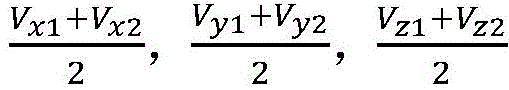
自动驾驶装置将该平均速度从激光雷达坐标系转换至自车坐标系可采用如下公式:The automatic driving device can use the following formula to convert the average speed from the lidar coordinate system to the self-vehicle coordinate system:
V1′=R1×V1+T1(1);V 1 ′=R 1 ×V 1 +T 1 (1);
其中,V1′为自车坐标系下的平均速度,V1为激光雷达坐标系下的平均速度,R1为激光雷达标定的旋转矩阵(外参),T1为该激光雷达标定的平移矩阵。Among them, V 1 ′ is the average speed in the self-vehicle coordinate system, V 1 is the average speed in the lidar coordinate system, R 1 is the rotation matrix (external parameter) of the lidar calibration, and T 1 is the translation of the lidar calibration. matrix.
自动驾驶装置将该平均速度从自车坐标系转换至相机坐标系可采用如下公式:The automatic driving device can use the following formula to convert the average speed from the vehicle coordinate system to the camera coordinate system:
V1″=R2×V1′+T2 (2);V 1 ″=R 2 ×V 1 ′+T 2 (2);
其中,V1″为相机坐标系下的平均速度,V1′为自车坐标系下的平均速度,R2为自动驾驶装置与相机之间的旋转矩阵,T2为该自动驾驶装置与相机之间的平移矩阵。Among them, V 1 ″ is the average speed in the camera coordinate system, V 1 ′ is the average speed in the self-vehicle coordinate system, R 2 is the rotation matrix between the automatic driving device and the camera, and T 2 is the automatic driving device and the camera. translation matrix between .
自动驾驶装置将该平均速度从激光雷达坐标系转换至相机坐标系可采用如下公式:The automatic driving device can convert the average speed from the lidar coordinate system to the camera coordinate system using the following formula:
V1″=R3×V1+T3 (3);V 1 ″=R 3 ×V 1 +T 3 (3);
其中,V1″为相机坐标系下的平均速度,V1为激光雷达坐标系下的平均速度,R3为激光雷达与相机之间的旋转矩阵,T3为该激光雷达与相机之间的平移矩阵。Among them, V 1 ″ is the average velocity in the camera coordinate system, V 1 is the average velocity in the lidar coordinate system, R 3 is the rotation matrix between the lidar and the camera, and T 3 is the lidar and the camera. Translation matrix.
匹配关系确定装置利用位移对参考特征点的像素坐标进行调整的公式如下:The formula for adjusting the pixel coordinates of the reference feature point by the device for determining the matching relationship is as follows:

其中,(x′,y′)为参考特征点调整后的像素坐标,(x,y)为该参考特征点调整前的像素坐标,Δt为第一时刻至第二时刻的时长,Vx″为V1″在X方向的分量,Vx″为V1″在Y方向的分量,即V1″为(Vx″,Vy″,Vz″)。应理解,参考特征点中包括的每个特征点的像素点均可采用公式(4)进行调整。Among them, (x', y') is the pixel coordinates after the reference feature point adjustment, (x, y) is the pixel coordinates before the reference feature point adjustment, Δt is the duration from the first moment to the second moment, V x ″ is the component of V 1 ″ in the X direction, V x ″ is the component of V 1 ″ in the Y direction, that is, V 1 ″ is (V x ″, V y ″, V z ″). It should be understood that the pixel point of each feature point included in the reference feature point can be adjusted by using formula (4).
在该实现方式中,利用动态障碍物从第一时刻至第二时刻的位移对参考特征点的像素坐标进行调整(即运动补偿),使得该参考特征点的像素坐标被调整后基本等同于静态障碍物的像素坐标,以便于更准确地确定第一图像和第二图像之间的匹配关系。In this implementation, the pixel coordinates of the reference feature point are adjusted (ie, motion compensation) by using the displacement of the dynamic obstacle from the first moment to the second moment, so that the pixel coordinates of the reference feature point are basically equivalent to static The pixel coordinates of the obstacle in order to more accurately determine the matching relationship between the first image and the second image.
自动驾驶装置在执行步骤302之前,需要确定N组特征点对中该动态障碍物对应的特征点以得到该目标特征点,以便于对该目标特征点的像素坐标进行调整。确定N组特征点对中动态障碍物对应的特征点以得到目标特征点可以是:确定该N组特征点对中位于第一投影区域和/或第二投影区域的特征点为该目标特征点;该第一投影区域为该第一图像中该动态障碍物的图像所处的区域,该第二投影区域为该第二图像中该动态障碍物的图像所处的区域。可选的,自动驾驶装置获得表征该动态障碍物在该第一时刻的特性的目标点云,将该目标点云投影到该第一图像以得到该第一投影区域;获得表征该动态障碍物在该第二时刻的特性的中间点云,将该中间点云投影到该第二图像以得到该第二投影区域。下面介绍点云投影到图像坐标系的方式,具体方式如下:Before performing
(1)激光雷达与相机(第一摄像头或第二摄像头)之间的外参(这里的外参主要是指激光雷达和相机之间的旋转矩阵RibeoTocam和平移向量TibeoTocam),把激光雷达得到的目标点云投影到相机坐标系,其投影公式为:(1) The external parameters between the lidar and the camera (the first camera or the second camera) (the external parameters here mainly refer to the rotation matrix R ibeoTocam and the translation vector T ibeoTocam between the lidar and the camera), the lidar The obtained target point cloud is projected to the camera coordinate system, and its projection formula is:
Pcam=PibeoTocam*Pibeo+TibeoTocam (5);P cam = P ibeoTocam * P ibeo + T ibeoTocam (5);
其中,Pibeo表示激光雷达感知到的动态障碍物的某个点在激光雷达坐标系中的位置, Pcam表示这个点在相机坐标系中的位置。Among them, P ibeo represents the position of a certain point of the dynamic obstacle perceived by the lidar in the lidar coordinate system, and P cam represents the position of this point in the camera coordinate system.
(2)通过相机的内参,将相机坐标系中的点转换到图像坐标系,其公式如下:(2) Convert the points in the camera coordinate system to the image coordinate system through the internal parameters of the camera, and the formula is as follows:
U=KPcam (6);U= KPcam (6);
其中,K为相机的内参矩阵,U为该点在图像坐标系下的坐标。Among them, K is the internal parameter matrix of the camera, and U is the coordinate of the point in the image coordinate system.
在实际应用中,自动驾驶装置可以通过激光雷达(ibeo)按照一定扫描频率扫描周围环境以得到障碍物在不同时刻的点云,通过神经网络(Neural Networks,NN)算法或则非NN算法利用不同时刻的点云确定障碍物的运动信息(例如位置、速度、包围盒和姿态等)。激光雷达可以实时或接近实时地将获取的点云提供给计算机系统101,每次获取的点云对应一个时间戳。可选的,相机(摄像头)实时或接近实时地将获取的图像提供给计算机系统101,每帧图像对应一个时间戳。应理解,计算机系统101可得到来自相机的图像序列以及来自激光雷达的点云序列。由于激光雷达和相机(camera)的频率不一致,因此两种传感器的时间戳通常不同步。在以相机的时间戳为基准的情况下,对通过激光雷达检测到的障碍物的运动信息进行插值运算。若激光雷达的扫描频率比相机的拍摄频率高的话,就进行内插,具体运算过程为:例如最新拍摄的相机时间为tcam,找到距离激光雷达输出中最近的两个时间tk和tk+1,其中,tk<tcam<tk+1;以位置插值计算为例,如tk时刻激光雷达检测到障碍物的位置为

其中,
前述实施例中,自动驾驶装置根据N组特征点对中各特征点对应的调整后的像素坐标,来确定第一图像和第二图像之间的匹配关系。在实际应用中,自动驾驶装置可以根据从第一图像和第二图像相匹配的多组特征点对中任意选取N组特征点对,并根据该N组特征点对中各特征点对应的调整后的像素坐标来确定第一图像和第二图像之间的匹配关系。由于 N组特征点对中可能存在噪声点等不能准确反映该第一图像和该第二图像的匹配关系的特征点对,因此需要选择N组能够准确反映该第一图像和该第二图像的匹配关系的特征点对,进而准确地确定第一图像和第二图像之间的匹配关系。为更准确地确定两帧图像之间的匹配关系,本申请实施例采用一种改进的RANSAC算法来确定前后两帧图像的匹配关系。In the foregoing embodiment, the automatic driving device determines the matching relationship between the first image and the second image according to the adjusted pixel coordinates corresponding to each feature point in the N groups of feature point pairs. In practical applications, the automatic driving device can arbitrarily select N groups of feature point pairs from multiple groups of feature point pairs matching the first image and the second image, and adjust the corresponding feature points according to the N groups of feature point pairs. Then the pixel coordinates are used to determine the matching relationship between the first image and the second image. Since there may be noise points and other feature point pairs in the N groups of feature point pairs that cannot accurately reflect the matching relationship between the first image and the second image, it is necessary to select N groups of feature point pairs that can accurately reflect the first image and the second image. feature point pairs of the matching relationship, thereby accurately determining the matching relationship between the first image and the second image. In order to more accurately determine the matching relationship between the two frames of images, an improved RANSAC algorithm is used in this embodiment of the present application to determine the matching relationship between the two frames of images before and after.
图4为本申请实施例提供的一种确定前后两帧图像的匹配关系的方法流程图。图4是对图3中的方法流程的进一步细化和完善。也就是说,图3的方法流程为图4中的方法流程的一部分。如图4所示,该方法可包括:FIG. 4 is a flowchart of a method for determining a matching relationship between two frames of images before and after according to an embodiment of the present application. FIG. 4 is a further refinement and improvement of the method flow in FIG. 3 . That is, the method flow of FIG. 3 is a part of the method flow of FIG. 4 . As shown in Figure 4, the method may include:
401、匹配关系确定装置确定第一图像中动态障碍物所处的第一投影区域以及第二图像中动态障碍物所处的第二投影区域。401. The matching relationship determining apparatus determines a first projection area where the dynamic obstacle is located in the first image and a second projection area where the dynamic obstacle is located in the second image.
前述实施例描述了将动态障碍物在第一时刻对应的目标点云投影至第一图像以得到第一投影区域,以及将动态障碍物在第二时刻对应的中间点云投影至第二图像以得到第二投影区域的方式,这里不再赘述。The foregoing embodiments describe projecting the target point cloud corresponding to the dynamic obstacle at the first moment to the first image to obtain the first projection area, and projecting the intermediate point cloud corresponding to the dynamic obstacle at the second moment to the second image to obtain the first projection area. The method for obtaining the second projection area will not be repeated here.
402、匹配关系确定装置从匹配特征点集中随机选择N组特征点对。402. The matching relationship determining apparatus randomly selects N groups of feature point pairs from the matching feature point set.
本申请实施例中,步骤402可在执行步骤401之前执行,也可以在执行步骤401之后执行。该匹配特征点集为对从该第一图像提取的特征点与从该第二图像提取的特征点做特征匹配得到的特征点对。自动驾驶装置在执行步骤402之前,可对第一图像进行特征提取以得到第一特征点集,对第二图像进行特征提取以得到第二特征点集;对该第一特征点集中的特征点与该第二特征点集中的特征点进行特征匹配以得到匹配特征点集。步骤402为步骤301的一种实现方式。In this embodiment of the present application,
403、匹配关系确定装置判断N组特征点对是否包括特殊特征点。403. The matching relationship determining apparatus determines whether the N groups of feature point pairs include special feature points.
特殊特征点是指该N组特征点对中处于第一投影区域和/或第二投影区域的特征点。若否,执行404;若是,执行405。The special feature points refer to the feature points located in the first projection area and/or the second projection area in the N groups of feature point pairs. If not, go to 404; if yes, go to 405.
404、匹配关系确定装置根据N组特征点中各特征点的像素坐标,计算第一图像与第二图像之间的匹配关系。404. The matching relationship determining device calculates the matching relationship between the first image and the second image according to the pixel coordinates of each feature point in the N groups of feature points.
本申请中,第一图像与第二图像之间的匹配关系可以是该第一图像和该第二图像之间的平移矩阵和旋转矩阵。In this application, the matching relationship between the first image and the second image may be a translation matrix and a rotation matrix between the first image and the second image.
405、匹配关系确定装置利用动态障碍物的运动状态信息对N组特征点对中目标特征点的像素坐标进行调整,并根据该N组特征点对中各特征点调整后的像素坐标确定第一图像和第二图像之间的匹配关系。405. The matching relationship determining device adjusts the pixel coordinates of the target feature points in the N groups of feature point pairs by using the motion state information of the dynamic obstacles, and determines the first pixel coordinates according to the adjusted pixel coordinates of each feature point in the N groups of feature point pairs. The matching relationship between the image and the second image.
该目标特征点属于该第一图像和/或该第二图像中该动态障碍物对应的特征点。该N组特征点对中除该目标特征点之外的特征点对应的像素坐标均保持不变。步骤405对应于图 3中的步骤302和步骤303。The target feature point belongs to the feature point corresponding to the dynamic obstacle in the first image and/or the second image. The pixel coordinates corresponding to the feature points other than the target feature point in the N groups of feature point pairs remain unchanged. Step 405 corresponds to step 302 and step 303 in FIG. 3 .
406、匹配关系确定装置根据匹配关系,将匹配特征点集中除N组特征点对之外的各特征点对分为内点和外点以得到内点集和外点集。406. The matching relationship determining device divides each feature point pair except the N groups of feature point pairs in the matching feature point set into inner points and outer points according to the matching relationship to obtain an inner point set and an outer point set.
根据匹配关系,将匹配特征点集中除N组特征点对之外的各特征点对分为内点和外点以得到内点集和外点集可以是依次检测该匹配特征点集中除N组特征点对之外的各特征点是否满足该匹配关系;若是,则确定该特征点对为内点,若否,则确定该特征点对为外点。According to the matching relationship, each feature point pair except the N groups of feature point pairs in the matching feature point set is divided into inner points and outer points to obtain the inner point set and the outer point set. Whether each feature point other than the feature point pair satisfies the matching relationship; if so, the feature point pair is determined to be an interior point; if not, the feature point pair is determined to be an exterior point.
407、匹配关系确定装置判断当前得到的内点集中的内点的个数是否最多。407. The matching relationship determining apparatus determines whether the number of inliers in the currently obtained inlier set is the largest.
若是,执行408;若否,执行402。图4中的方法流程是一个多次迭代的流程,判断当前得到的内点集中的内点的个数是否最多可以是判断当前得到的内点集与之前得到的各内点集相比是否包括的内点的个数最多。If yes, go to 408; if not, go to 402. The method flow in Fig. 4 is a process of multiple iterations, and judging whether the number of inliers in the currently obtained inlier set can be at most is to judge whether the currently obtained inlier set contains a has the largest number of interior points.
408、匹配关系确定装置判断当前迭代次数是否满足终止条件。408. The matching relationship determining apparatus determines whether the current iteration number satisfies the termination condition.
若是,执行409;若否,执行402。当前迭代次数可以是当前已执行的步骤402的次数。判断当前迭代次数是否满足终止条件可以是判断当前迭代次数是否大于或等于M,M为大于1的整数。M可以是5、10、20、50、100等。If yes, go to 409; if not, go to 402. The current number of iterations may be the number of times step 402 has currently been performed. Determining whether the current iteration number satisfies the termination condition may be judging whether the current iteration number is greater than or equal to M, where M is an integer greater than 1. M can be 5, 10, 20, 50, 100, etc.
409、结束本流程,且将目标匹配关系作为第一图像与第二图像之间的匹配关系。409. End the process, and use the target matching relationship as the matching relationship between the first image and the second image.
该目标匹配关系为已确定的第一图像和该第二图像之间的两个或两个以上匹配关系中较优的匹配关系。可以理解,根据越优的匹配关系,将匹配特征点集中除N组特征点对之外的各特征点对分为内点和外点,可以得到越多的内点。The target matching relationship is a better matching relationship among two or more matching relationships between the determined first image and the second image. It can be understood that, according to the better matching relationship, each feature point pair except the N groups of feature point pairs in the matching feature point set is divided into inner points and outer points, and more inner points can be obtained.
可以理解,通过执行步骤405可以使得动态障碍物对应的特征点对包括的两个特征点之间的关系与静态障碍物对应的特征点对包括的两个特征点之间的关系基本一致。也就是说,执行步骤405之后,N组特征点对均可视为静态障碍物对应的特征点对,这样就可以减少动态障碍物对应的特征点对的影响,因此能够较快的确定一组较优的匹配关系。另外,采用RANSAC算法可以从已确定的第一图像和第二图像之间的多个匹配关系中,选择一个较优的匹配关系,从而保证确定的匹配关系的质量。It can be understood that the relationship between the two feature points included in the feature point pair corresponding to the dynamic obstacle can be basically consistent with the relationship between the two feature points included in the feature point pair corresponding to the static obstacle by performing
本申请实施例中,采用RANSAC算法可准确、快速地确定第一图像与第二图像之间的匹配关系。In this embodiment of the present application, the RANSAC algorithm can be used to accurately and quickly determine the matching relationship between the first image and the second image.
前述实施例未详细描述如何确定第一图像和第二图像的匹配关系的方式。下面介绍如何利用第一图像和第二图像对应的多个特征点对计算这两个图像之间的旋转矩阵R和平移矩阵T。上述匹配特征点集包括对从该第一图像提取的特征点与从该第二图像提取的特征点做特征匹配得到的多组特征点对。该匹配特征点集中每组特征点对包括两个相匹配的特征点,其中一个特征点为从第一图像提取的特征点,另一个特征点为从第二图像提取的特征点,该第一图像和该第二图像分别为自动驾驶装置在第一时刻和第二时刻采集的图像。可以理解,多组特征点对包括点集A和点集B,点集A中的特征点为从第一图像提取的特征点,点集B中的特征点为从第二图像提取的特征点,这两个点集合的元素数目相同且一一对应。点集A可以是N组特征点对中从第一图像提取的特征点,点集B可以是N组特征点对中从第二图像提取的特征点,这两个点集之间的旋转矩阵和平移矩阵就是第一图像和第二图像之间的旋转矩阵和平移矩阵。The foregoing embodiments do not describe in detail how to determine the matching relationship between the first image and the second image. The following describes how to use multiple feature point pairs corresponding to the first image and the second image to calculate the rotation matrix R and the translation matrix T between the two images. The above-mentioned matching feature point set includes multiple sets of feature point pairs obtained by feature matching between the feature points extracted from the first image and the feature points extracted from the second image. Each set of feature point pairs in the matched feature point set includes two matched feature points, one of which is a feature point extracted from the first image, the other feature point is a feature point extracted from the second image, and the first feature point is a feature point extracted from the second image. The image and the second image are images collected by the automatic driving device at the first moment and the second moment, respectively. It can be understood that the multiple sets of feature point pairs include a point set A and a point set B, the feature points in the point set A are the feature points extracted from the first image, and the feature points in the point set B are the feature points extracted from the second image. , these two point sets have the same number of elements and one-to-one correspondence. The point set A can be the feature points extracted from the first image in the N groups of feature point pairs, the point set B can be the feature points extracted from the second image in the N groups of feature point pairs, the rotation matrix between the two point sets And the translation matrix is the rotation matrix and translation matrix between the first image and the second image.
为了确定两个点集之间的旋转矩阵和平移矩阵,可以将这个问题建模成如下的公式:To determine the rotation and translation matrices between two sets of points, the problem can be modeled as the following formula:
B=R*A+t (8);B=R*A+t(8);
其中,B表示点集B中的特征点的像素坐标,A表示点集A中特征点的像素坐标。为了寻找这两个点集之间的旋转矩阵和平移矩阵,通常需要以下三个步骤:Among them, B represents the pixel coordinates of the feature points in the point set B, and A represents the pixel coordinates of the feature points in the point set A. In order to find the rotation and translation matrices between these two point sets, the following three steps are usually required:
(1)、计算点集合的中心点,计算公式如下:(1), calculate the center point of the point set, the calculation formula is as follows:

其中,


(2)、将点集合移动到原点,计算最优旋转矩阵R。(2), move the point set to the origin, and calculate the optimal rotation matrix R.
为了计算旋转矩阵R,需要消除平移矩阵t的影响,所以首先需要将点集重新中心化,生成新的点集A′和点集B′,然后计算点集A′和点集B′之间的协方差矩阵。In order to calculate the rotation matrix R, it is necessary to eliminate the influence of the translation matrix t, so the point set needs to be re-centered first to generate new point set A' and point set B', and then calculate the distance between point set A' and point set B' The covariance matrix of .
采用如下公式将点集重新中心化:The point set is re-centered using the following formula:

其中,A′i为点集A′中的第i特征点的像素坐标,B′i为点集B′中的第i特征点的像素坐标。Among them, A' i is the pixel coordinate of the ith feature point in the point set A', and B' i is the pixel coordinate of the ith feature point in the point set B'.
计算点集之间的协方差矩阵H,计算公式如下;Calculate the covariance matrix H between point sets, the calculation formula is as follows;

通过奇异值分解(Singular Value Decomposition,SVD)方法获得矩阵的U、S和V,计算点集之间的旋转矩阵,公式如下:The U, S and V of the matrix are obtained by the Singular Value Decomposition (SVD) method, and the rotation matrix between the point sets is calculated. The formula is as follows:
[UVD]=SVD(H)(14);[UVD]=SVD(H)(14);
R=VUT (15);R= VUT (15);
其中,R为点集A和点集B之间的旋转矩阵,即第一图像和第二图像之间的旋转矩阵。Among them, R is the rotation matrix between point set A and point set B, that is, the rotation matrix between the first image and the second image.
(3)、计算平移矩阵(3), calculate the translation matrix
采用如下公式计算平移矩阵:The translation matrix is calculated using the following formula:
t=-R×uA+uB (16);t=-R×u A +u B (16);
其中,t为点集A和点集B之间的平移矩阵,即第一图像和第二图像之间的平移矩阵。Among them, t is the translation matrix between the point set A and the point set B, that is, the translation matrix between the first image and the second image.
应理解,上述仅是本申请实施例提供的一种确定图像帧之间的匹配关系的一种实现方式,还可以采用其他方式来确定图像帧之间的匹配关系。It should be understood that the above is only an implementation manner of determining the matching relationship between the image frames provided by the embodiment of the present application, and other manners may also be used to determine the matching relationship between the image frames.
前述实施例描述了确定前后两帧图像之间的匹配关系的实现方式。在实际应用中,可以依次确定自动驾驶装置采集的各相邻图像帧之间的匹配关系,进而确定各帧图像与参考帧图像之间的匹配关系。该参考帧图像可以是自动驾驶装置在一次行驶过程中采集的第一帧图像。举例来说,自动驾驶装置在某段时间内按照时间先后顺序依次采集到第1帧图像至第1000帧图像,该自动驾驶装置可以分别确定相邻两帧图像之间的平移矩阵和旋转矩阵,例如第1帧图像和第2帧图像之间的平移矩阵和旋转矩阵,并根据这些平移矩阵和旋转矩阵确定这1000帧图像中除该第1帧图像之外的任一帧图像与该第一帧图像之间的匹配关系,进而计算各帧图像的重投影误差。又举例来说,第一图像和第二图像之间的旋转矩阵为R4,平移矩阵为T4;第二图像和第五图像之间的旋转矩阵为R5,平移矩阵为T5;则该第一图像和该第五图像之间的旋转矩阵为(R4×R5),该第一图像和该第五图像之间的平移矩阵为(R4×T5+T4)。在一些实施例中,自动驾驶装置采集到一帧图像就确定该帧图像与该帧图像的前一帧图像之间的匹配关系,这样就可以得到任意两帧相邻图像之间的匹配关系,进而得到任意两帧图像之间的匹配关系。在实际应用中,匹配关系确定装置在确定当前帧(即当前时刻采集的图像帧)与参考帧之间的平移矩阵和旋转矩阵之后,可以利用该平移矩阵和旋转矩阵将当前帧中的特征点对应的三维空间坐标从自车坐标系转换至参考坐标系,以便于计算该当前帧的重投影误差。The foregoing embodiments describe the implementation of determining the matching relationship between the two frames of images before and after. In practical applications, the matching relationship between adjacent image frames collected by the automatic driving device can be sequentially determined, and then the matching relationship between each frame image and the reference frame image can be determined. The reference frame image may be the first frame image collected by the automatic driving device during a driving process. For example, the automatic driving device sequentially collects the first frame of images to the 1000th frame of images in a chronological order within a certain period of time, and the automatic driving device can determine the translation matrix and rotation matrix between two adjacent frames of images respectively, For example, the translation matrix and rotation matrix between the first frame image and the second frame image, and according to these translation matrices and rotation matrices, determine the relationship between any frame image except the first frame image in the 1000 frame images and the first frame image. The matching relationship between frame images is calculated, and the reprojection error of each frame image is calculated. For another example, the rotation matrix between the first image and the second image is R 4 , and the translation matrix is T 4 ; the rotation matrix between the second image and the fifth image is R 5 , and the translation matrix is T 5 ; then The rotation matrix between the first image and the fifth image is (R 4 ×R 5 ), and the translation matrix between the first image and the fifth image is (R 4 ×T 5 +T 4 ). In some embodiments, the automatic driving device determines the matching relationship between the frame image and the previous frame image of the frame image after collecting one frame of image, so that the matching relationship between any two adjacent images can be obtained, Then, the matching relationship between any two frames of images is obtained. In practical applications, after determining the translation matrix and rotation matrix between the current frame (that is, the image frame collected at the current moment) and the reference frame, the matching relationship determining device can use the translation matrix and rotation matrix to determine the feature points in the current frame. The corresponding three-dimensional space coordinates are converted from the ego vehicle coordinate system to the reference coordinate system, so as to calculate the reprojection error of the current frame.
前述实施例描述了如何更准确地确定图像帧之间的匹配关系。计算图像帧之间的匹配关系的一个重要应用是计算当前帧与参考帧之间的匹配关系,进而计算该当前帧的重投影误差。本申请实施例还提供了一种重投影误差计算方法,下面具体描述该重投影误差计算方法。The foregoing embodiments describe how to more accurately determine the matching relationship between image frames. An important application of calculating the matching relationship between image frames is to calculate the matching relationship between the current frame and the reference frame, and then calculate the reprojection error of the current frame. The embodiment of the present application also provides a reprojection error calculation method, which is specifically described below.
图5为本申请实施例提供的一种重投影误差计算方法流程图。如图5所示,该方法可包括:FIG. 5 is a flowchart of a reprojection error calculation method provided by an embodiment of the present application. As shown in Figure 5, the method may include:
501、重投影误差计算装置利用动态障碍物的运动状态信息对第一空间坐标中第一特征点对应的空间坐标进行调整以得到第二空间坐标。501. The reprojection error calculation device uses the motion state information of the dynamic obstacle to adjust the spatial coordinates corresponding to the first feature point in the first spatial coordinates to obtain the second spatial coordinates.
重投影误差计算装置可以是自动驾驶装置,也可以是服务器、电脑等计算机设备。在一些实施例中,自动驾驶装置采集第一图像,并执行图5的方法流程来计算该第一图像的重投影误差。在一些实施例中,自动驾驶装置可以将其采集的图像数据以及点云数据等发送至重投影误差计算装置(例如服务器);该重投影误差计算装置执行图5中的方法,根据这些数据来计算第一图像的重投影误差。该第一空间坐标包括第一图像中各特征点对应的空间坐标,该第一特征点为该第一图像中该动态障碍物对应的特征点。该第一图像可以为自动驾驶装置在第二时刻采集的图像。该第一图像中除该第一特征点之外的特征点的像素坐标均保持不变。该运动状态信息可以包括该自动驾驶装置从第一时刻至该第二时刻的位移(对应一个平移矩阵)和姿态变化(对应一个选择矩阵)。The reprojection error calculation device may be an automatic driving device, or computer equipment such as a server and a computer. In some embodiments, the automatic driving device acquires the first image, and executes the method flow of FIG. 5 to calculate the reprojection error of the first image. In some embodiments, the automatic driving device may send the image data and point cloud data it has collected to a reprojection error computing device (eg, a server); the reprojection error computing device executes the method in FIG. Calculate the reprojection error for the first image. The first spatial coordinates include spatial coordinates corresponding to each feature point in the first image, and the first feature point is a feature point corresponding to the dynamic obstacle in the first image. The first image may be an image collected by the automatic driving device at the second moment. The pixel coordinates of the feature points other than the first feature point in the first image remain unchanged. The motion state information may include displacement (corresponding to a translation matrix) and attitude change (corresponding to a selection matrix) of the automatic driving device from the first moment to the second moment.
可选的,重投影误差计算装置在执行步骤501之前,可以确定该第一图像中各特征点在参考坐标系中对应的三维空间坐标以得到第一空间坐标,以及确定该第一空间坐标中第一特征点对应的空间坐标。该参考坐标系可以是自动驾驶装置在本次行驶的起始地点建立的世界坐标系。后续再详述确定第一空间坐标以及第一特征点对应的空间坐标的实现方式。Optionally, before performing step 501, the reprojection error calculation device may determine the three-dimensional space coordinates corresponding to each feature point in the first image in the reference coordinate system to obtain the first space coordinates, and determine the first space coordinates. The spatial coordinates corresponding to the first feature point. The reference coordinate system may be a world coordinate system established by the automatic driving device at the starting point of the current driving. The implementation manner of determining the first space coordinate and the space coordinate corresponding to the first feature point will be described in detail later.
502、重投影误差计算装置将第二空间坐标投影至第一图像以得到第一像素坐标。502. The reprojection error calculating device projects the second spatial coordinates to the first image to obtain the first pixel coordinates.
该第二空间坐标可以是在参考坐标系下的空间坐标。重投影误差计算装置将第二空间坐标投影至第一图像以得到第一像素坐标可以是将该参考坐标系下的该第二空间坐标投影至第一图像以得到第一像素坐标。由于需要在一个固定不变的坐标系下计算自动驾驶装置采集到的每帧图像的重投影误差,因此需要确定第二图像中各特征点在参考坐标系下对应的三维空间坐标以得到第一空间坐标。该参考坐标系是一个固定的坐标系,不像自车坐标系会发生改变。利用动态障碍物的运动状态信息对第一空间坐标中第一特征点对应的空间坐标进行调整是利用动态障碍物的运动状态信息对该第一特征点在参考坐标系下对应的空间坐标进行调整。The second spatial coordinates may be spatial coordinates in a reference coordinate system. The reprojection error calculating means may project the second spatial coordinates to the first image to obtain the first pixel coordinates by projecting the second spatial coordinates in the reference coordinate system to the first image to obtain the first pixel coordinates. Since the reprojection error of each frame of image collected by the automatic driving device needs to be calculated in a fixed coordinate system, it is necessary to determine the corresponding three-dimensional space coordinates of each feature point in the second image in the reference coordinate system to obtain the first space coordinates. The reference coordinate system is a fixed coordinate system, unlike the ego vehicle coordinate system that changes. Using the motion state information of the dynamic obstacle to adjust the spatial coordinate corresponding to the first feature point in the first spatial coordinate is to use the motion state information of the dynamic obstacle to adjust the spatial coordinate corresponding to the first feature point in the reference coordinate system .
503、重投影误差计算装置根据第一像素坐标和第二像素坐标,计算第一图像的重投影误差。503. The reprojection error calculating means calculates the reprojection error of the first image according to the first pixel coordinates and the second pixel coordinates.
该第二像素坐标包括该第一图像中各特征点的像素坐标,第一像素坐标包括的各像素坐标与该第二像素坐标包括的各像素坐标一一对应。该第一像素坐标包括的每个像素坐标对应一个描述子,每个描述子用于描述其对应的特征点;该第二像素坐标包括的每个像素坐标也对应一个描述子。可以理解,第一像素坐标和第二像素坐标包括的像素坐标中对应的描述子相同的像素坐标相对应。The second pixel coordinates include pixel coordinates of each feature point in the first image, and each pixel coordinate included in the first pixel coordinates corresponds to each pixel coordinate included in the second pixel coordinates one-to-one. Each pixel coordinate included in the first pixel coordinate corresponds to a descriptor, and each descriptor is used to describe its corresponding feature point; each pixel coordinate included in the second pixel coordinate also corresponds to a descriptor. It can be understood that the first pixel coordinates and the pixel coordinates included in the second pixel coordinates correspond to the same pixel coordinates of the corresponding descriptors.
可选的,重投影误差计算装置在执行步骤503之前,可利用该位移对该第一图像中该第一特征点的像素坐标进行调整以得到该第二像素坐标,该第一图像中除该第一特征点之外的特征点的像素坐标均保持不变。利用该位移对该第一图像中该第一特征点的像素坐标进行调整的实现方式可以与前文描述的利用位移对参考特征点的像素坐标进行调整的实现方式相同,这里不再详述。Optionally, before performing step 503, the reprojection error calculation device may use the displacement to adjust the pixel coordinates of the first feature point in the first image to obtain the second pixel coordinates, which are divided by the first image. The pixel coordinates of the feature points other than the first feature point remain unchanged. The implementation manner of adjusting the pixel coordinates of the first feature point in the first image by using the displacement may be the same as the implementation manner of adjusting the pixel coordinates of the reference feature point by using the displacement described above, and will not be described in detail here.
重投影误差:投影的点与该帧图像上的测量点之间的误差,投影的点可以是该帧图像中的各特征点对应的三维空间坐标投影至该帧图像的坐标点(即第一像素坐标),测量点可以是这些特征点在该帧图像中的坐标点(即第二像素坐标)。重投影误差计算装置根据第一像素坐标和第二像素坐标,计算第一图像的重投影误差可以是计算第一像素坐标和第二像素坐标中一一对应的像素坐标之差。举例来说,某个特征点在第一像素坐标中对应的像素坐标为(U1,V1),该特征点在第二像素坐标中对应的像素坐标为(U2,V2),则该特征点的重投影误差为

本申请实施例中,利用动态障碍物的运动状态信息对第一空间坐标中第一特征点对应的空间坐标进行调整,使得该第一特征点对应的空间坐标基本等同于静态障碍物对应的特征点所对应的空间坐标;在计算重投影误差时可以有效减少动态障碍物对应的特征点的影响,得到的重投影误差更准确。In the embodiment of the present application, the motion state information of the dynamic obstacle is used to adjust the spatial coordinate corresponding to the first feature point in the first spatial coordinate, so that the spatial coordinate corresponding to the first feature point is basically equal to the feature corresponding to the static obstacle The spatial coordinates corresponding to the point; when calculating the reprojection error, the influence of the feature points corresponding to the dynamic obstacles can be effectively reduced, and the obtained reprojection error is more accurate.
重投影误差计算装置在执行步骤501之前,需要确定第一空间坐标以及第一特征点。下面描述如何得到第一空间坐标以及第一特征点的方式。Before performing step 501, the reprojection error calculating apparatus needs to determine the first spatial coordinate and the first feature point. The following describes how to obtain the first space coordinate and the first feature point.
重投影误差计算装置可采用如下方式确定第一特征点:重投影误差计算装置在执行步骤501之前,获得第一摄像头在第二时刻采集的第一图像以及第二摄像头在该第二时刻采集的第二图像;对该第一图像进行特征提取以得到第一原始特征点集,对第二图像进行特征提取以得到第二原始特征点集;对该第一原始特征点集中的特征点与该第二原始特征点集中的特征点进行特征匹配以得到第一特征点集,该第一特征点集包括的特征点为该第一原始特征点集中与该第二原始特征点集中的特征点相匹配的特征点;确定该第一特征点集中动态障碍物对应的特征点以得到该第一特征点。The reprojection error calculation device may determine the first feature point in the following manner: before the reprojection error calculation device executes step 501, obtains the first image collected by the first camera at the second moment and the image collected by the second camera at the second moment. the second image; perform feature extraction on the first image to obtain a first original feature point set, and perform feature extraction on the second image to obtain a second original feature point set; the feature points in the first original feature point set are the same as the The feature points in the second original feature point set are feature matched to obtain a first feature point set, and the feature points included in the first feature point set are the feature points in the first original feature point set and the second original feature point set. Matching feature points; determining the feature points corresponding to the dynamic obstacles in the first feature point set to obtain the first feature points.
重投影误差计算装置可采用如下方式确定该第一特征点集中动态障碍物对应的特征点以得到该第一特征点:获得目标点云,该目标点云为表征该动态障碍物在该第二时刻的特性的点云;将该目标点云投影到该第一图像以得到目标投影区域;确定第一特征点集中位于该目标投影区域的特征点为该第一特征点。The reprojection error calculation device may determine the feature points corresponding to the dynamic obstacles in the first feature point set in the following manner to obtain the first feature points: obtain a target point cloud, and the target point cloud is used to represent the dynamic obstacle in the second feature point cloud. The point cloud of the characteristics of the time; project the target point cloud to the first image to obtain the target projection area; determine the first feature points that are concentrated in the target projection area as the first feature point.
重投影误差计算装置在获得第一原始特征点集和第二原始特征点集之后,可采用如下方式确定第一空间坐标;对该第一原始特征点集中的特征点与该第二原始特征点集中的特征点进行特征匹配以得到第一特征点集,其中,该第一特征点集包括多组特征点对,每组特征点对包括两个相匹配的特征点,一个特征点来自于该第一原始特征点集,另一个特征点来自于该第二原始特征点集;采用三角化公式根据第一特征点集中的每组特征点对确定一个三维空间坐标,得到该第一空间坐标。每组特征点对中一个特征点为从该第一图像提取的,另一个为从该第二图像提取的。由一组特征点对计算得到的一个三维空间坐标即为该组特征点对包括的两个特征点对应的空间坐标。该第一特征点包含于该第一特征点集。三角化最早由高斯提出,并应用于测量学中。简单来讲就是:在不同的位置观测同一个三维点P(x,y,z),已知在不同位置处观察到的三维点的二维投影点X1(x1,y1),X2(x2,y2),利用三角关系,恢复出该三维点的深度信息,即三维空间坐标。三角化主要是通过匹配的特征点(即像素点)来计算特征点在相机坐标系下的三维坐标。图6为一种三角化过程示意图。如图6所示,P1表示三维点P在O1(左目坐标系)中的坐标(即二维投影点),P2表示三维点P在O2(右目坐标系)中的坐标(即二维投影点),P1和P2为匹配的特征点。三角化公式如下:After obtaining the first original feature point set and the second original feature point set, the reprojection error calculation device may determine the first spatial coordinates in the following manner; the feature points in the first original feature point set and the second original feature point Feature matching is performed on the centralized feature points to obtain a first feature point set, wherein the first feature point set includes multiple sets of feature point pairs, each set of feature point pairs includes two matched feature points, and one feature point comes from the The first original feature point set, and the other feature point comes from the second original feature point set; a triangulation formula is used to determine a three-dimensional space coordinate according to each group of feature point pairs in the first feature point set, and the first space coordinate is obtained. In each set of feature point pairs, one feature point is extracted from the first image, and the other is extracted from the second image. A three-dimensional space coordinate calculated from a set of feature point pairs is the space coordinates corresponding to the two feature points included in the set of feature point pairs. The first feature point is included in the first feature point set. Triangulation was first proposed by Gauss and used in surveying. Simply put, the same three-dimensional point P(x, y, z) is observed at different positions, and the two-dimensional projection points X1(x1, y1), X2(x2, y2), using the triangular relationship to recover the depth information of the three-dimensional point, that is, the three-dimensional space coordinates. Triangulation mainly calculates the three-dimensional coordinates of the feature points in the camera coordinate system through the matched feature points (ie, pixel points). FIG. 6 is a schematic diagram of a triangulation process. As shown in Figure 6, P1 represents the coordinates of the three-dimensional point P in O1 (left-eye coordinate system) (ie, the two-dimensional projection point), and P2 represents the coordinates of the three-dimensional point P in O2 (right-eye coordinate system) (ie, the two-dimensional projection point). ), and P1 and P2 are matched feature points. The triangulation formula is as follows:

公式(17)中s1表示特征点在O1(左目坐标系)中的尺度,s2表示特征点在O2(右目坐标系)中的尺度,R和t分别表示从左目摄像头到右目摄像头之间的旋转矩阵和平移矩阵。T (大写)表示矩阵的转置。应理解,利用三角关系确定特征点的三维空间坐标仅是一种可选的确定特征点的三维空间坐标的方式,还可以采用其他方式确定特征点的三维空间坐标,本申请不作限定。In formula (17), s1 represents the scale of the feature point in O1 (left-eye coordinate system), s2 represents the scale of the feature point in O2 (right-eye coordinate system), and R and t respectively represent the rotation from the left-eye camera to the right-eye camera. matrix and translation matrix. T (uppercase) represents the transpose of the matrix. It should be understood that using the triangular relationship to determine the three-dimensional space coordinates of the feature points is only an optional way to determine the three-dimensional space coordinates of the feature points, and other methods may also be used to determine the three-dimensional space coordinates of the feature points, which are not limited in this application.
前述实施例未详述步骤501的实现方式,下面描述如何利用动态障碍物的运动状态信息对第一空间坐标中第一特征点对应的空间坐标进行调整以得到第二空间坐标的实现方式。The foregoing embodiments do not describe the implementation of step 501 in detail. The following describes an implementation of how to use the motion state information of the dynamic obstacle to adjust the spatial coordinates corresponding to the first feature point in the first spatial coordinates to obtain the second spatial coordinates.
该运动状态信息可以包括该自动驾驶装置从第一时刻至该第二时刻的位移(对应一个平移矩阵T6)和姿态变化(对应一个旋转矩阵R6)。The motion state information may include displacement (corresponding to a translation matrix T 6 ) and attitude change (corresponding to a rotation matrix R 6 ) of the automatic driving device from the first moment to the second moment.
举例来说,旋转矩阵R6表征自动驾驶装置从第一时刻至第二时刻的姿态变化,平移矩阵T6表征该自动驾驶装置从第一时刻至第二时刻的位移,重投影误差计算装置可采用如下公式对该第一特征点对应的空间坐标P进行调整(即运动补偿):For example, the rotation matrix R 6 represents the attitude change of the automatic driving device from the first time to the second time, the translation matrix T 6 represents the displacement of the automatic driving device from the first time to the second time, and the reprojection error calculation device may The following formula is used to adjust the spatial coordinate P corresponding to the first feature point (ie, motion compensation):
P′=R6P+T6 (18);P'=R 6 P+T 6 (18);
其中,P′为该第一特征点对应的调整后的空间坐标,即补偿后的特征点坐标,P′为一个三维向量;R6为一个3行3列的矩阵,T6为一个三维向量。例如,R1为
可选的,重投影误差计算装置计算旋转矩阵R6的方式如下:通过激光雷达获取动态障碍物在第一时刻的第一角速度以及在第二时刻的第二角速度;计算该第一角速度和该第二角速度的平均值;计算该平均值和第一时长的乘积得到旋转角度α,该第一时长为该第一时刻与该第二时刻之间的时长;根据该旋转角度得到第一旋转矩阵,该第一旋转矩阵为激光雷达坐标系下的旋转矩阵;使用激光雷达的外参(激光雷达的朝向和位置)将该第一旋转矩阵从激光雷达坐标系转换至自车坐标系以得到第二旋转矩阵;将该第二旋转矩阵从自车坐标系转换至参考坐标系,得到旋转矩阵R6。可以理解,旋转矩阵R6为该动态障碍物在参考坐标系下从第一时刻至第二时刻的姿态变化对应的旋转矩阵。在实际应用中,自动驾驶装置可通过激光雷达检测得到动态障碍物在不同时刻的角速度。重投影误差计算装置可以采用如下公式将该第一旋转矩阵从激光雷达坐标系转换至自车坐标系以得到第二旋转矩阵:Optionally, the reprojection error calculation device calculates the rotation matrix R 6 in the following manner: obtain the first angular velocity of the dynamic obstacle at the first moment and the second angular velocity at the second moment through the lidar; calculate the first angular velocity and the The average value of the second angular velocity; calculate the product of the average value and the first duration to obtain the rotation angle α, and the first duration is the duration between the first moment and the second moment; obtain the first rotation matrix according to the rotation angle , the first rotation matrix is the rotation matrix in the lidar coordinate system; use the external parameters of the lidar (the orientation and position of the lidar) to convert the first rotation matrix from the lidar coordinate system to the vehicle coordinate system to obtain the first rotation matrix. Two rotation matrices; convert the second rotation matrix from the ego vehicle coordinate system to the reference coordinate system to obtain a rotation matrix R 6 . It can be understood that the rotation matrix R 6 is the rotation matrix corresponding to the posture change of the dynamic obstacle in the reference coordinate system from the first moment to the second moment. In practical applications, the automatic driving device can detect the angular velocity of dynamic obstacles at different times through lidar detection. The reprojection error calculation device can use the following formula to convert the first rotation matrix from the lidar coordinate system to the ego vehicle coordinate system to obtain the second rotation matrix:
R6′=R1×R6″ (19);R 6 ′=R 1 ×R 6 ″ (19);
R6′为第二旋转矩阵,R6″为第一旋转矩阵,R1为激光雷达标定的旋转矩阵。R 6 ′ is the second rotation matrix, R 6 ″ is the first rotation matrix, and R 1 is the rotation matrix calibrated by the lidar.
重投影误差计算装置可以采用如下公式将该第二旋转矩阵从自车坐标系转换至参考坐标系以得到旋转矩阵R6:The reprojection error calculation device can convert the second rotation matrix from the ego vehicle coordinate system to the reference coordinate system by adopting the following formula to obtain the rotation matrix R 6 :
R6=R7×R6′ (20);R 6 =R 7 ×R 6 ′ (20);
R6为该动态障碍物在参考坐标系下从第一时刻至第二时刻的姿态变化对应的旋转矩阵, R6′为第二旋转矩阵,R7为第一图像与参考帧图像之间的旋转矩阵。重投影误差计算装置与匹配关系确定装置可以是同一装置。前述实施例描述了确定任一帧图像与参考帧之间的平移矩阵和旋转矩阵的实现方式,这里不再详述。R 6 is the rotation matrix corresponding to the posture change of the dynamic obstacle from the first moment to the second moment in the reference coordinate system, R 6 ′ is the second rotation matrix, and R 7 is the rotation matrix between the first image and the reference frame image rotation matrix. The reprojection error calculation device and the matching relationship determination device may be the same device. The foregoing embodiments describe the implementation manner of determining the translation matrix and the rotation matrix between any frame of image and the reference frame, and will not be described in detail here.
可选的,重投影误差计算装置计算平移矩阵T6的方式如下:通过激光雷达获取动态障碍物在第一时刻的第一速度以及在第二时刻的第二速度;计算该第一速度和该第二速度的平均值;计算该平均值和第二时长的乘积得到第一平移矩阵,该第二时长为该第一时刻与该第二时刻之间的时长,该第一平移矩阵为在激光雷达坐标系下的平移矩阵;使用激光雷达的外参(激光雷达的朝向和位置)将该第一平移矩阵从激光雷达坐标系转换至自车坐标系以得到第二平移矩阵;将该第二平移矩阵从该自车坐标系转换至参考坐标系,得到平移矩阵T6。平移矩阵T6可以理解为该动态障碍物在参考坐标系下从第一时刻至第二时刻的位置变化对应的平移矩阵。在实际应用中,自动驾驶装置可通过激光雷达检测得到动态障碍物在不同时刻的速度。重投影误差计算装置可以采用如下公式将该第一平移矩阵从激光雷达坐标系转换至自车坐标系以得到第二平移矩阵:Optionally, the method for calculating the translation matrix T6 by the reprojection error calculating device is as follows: obtaining the first velocity of the dynamic obstacle at the first moment and the second velocity at the second moment through the lidar; calculating the first velocity and the second velocity. The average value of the second speed; calculate the product of the average value and the second duration to obtain a first translation matrix, the second duration is the duration between the first moment and the second moment, and the first translation matrix is the laser The translation matrix in the radar coordinate system; use the external parameters of the lidar (the orientation and position of the lidar) to convert the first translation matrix from the lidar coordinate system to the ego vehicle coordinate system to obtain the second translation matrix; this second translation matrix The translation matrix is transformed from the ego vehicle coordinate system to the reference coordinate system to obtain the translation matrix T 6 . The translation matrix T6 can be understood as a translation matrix corresponding to the position change of the dynamic obstacle in the reference coordinate system from the first moment to the second moment. In practical applications, automatic driving devices can detect the speed of dynamic obstacles at different times through lidar detection. The reprojection error calculation device can use the following formula to convert the first translation matrix from the lidar coordinate system to the ego vehicle coordinate system to obtain the second translation matrix:
T6′=R1×T6″+T1 (21);T 6 ′=R 1 ×T 6 ″+T 1 (21);
T6′为第二平移矩阵,R6″为第一平移矩阵,R1为激光雷达标定的旋转矩阵,T1为激光雷达标定的平移矩阵。重投影误差计算装置可以采用如下公式将该第二平移矩阵从自车坐标系转换至参考坐标系以得到第二平移矩阵:T 6 ′ is the second translation matrix, R 6 ″ is the first translation matrix, R 1 is the rotation matrix calibrated by lidar, and T 1 is the translation matrix calibrated by lidar. The reprojection error calculation device can use the following formula to calculate the first translation matrix. The second translation matrix is transformed from the ego coordinate system to the reference coordinate system to obtain the second translation matrix:
T6=R7×T6′+T7 (22);T 6 =R 7 ×T 6 ′+T 7 (22);
T6为该动态障碍物在参考坐标系下从第一时刻至第二时刻的位置变化对应的平移矩阵, T6′为第二平移矩阵,R7为第一图像与参考帧图像之间的旋转矩阵,T7为第一图像与参考帧图像之间的平移矩阵。T 6 is the translation matrix corresponding to the position change of the dynamic obstacle from the first moment to the second moment in the reference coordinate system, T 6 ′ is the second translation matrix, and R 7 is the difference between the first image and the reference frame image Rotation matrix, T7 is the translation matrix between the first image and the reference frame image.
在该实现方式中,利用动态障碍物从第一时刻至第二时刻的位移对第一特征点的像素坐标进行调整(即运动补偿),使得该第一特征点的像素坐标被调整后基本等同于静态障碍物的像素坐标,以便于更准确地该第一图像的重投影误差。In this implementation, the pixel coordinates of the first feature point are adjusted (ie, motion compensation) using the displacement of the dynamic obstacle from the first moment to the second moment, so that the adjusted pixel coordinates of the first feature point are basically equivalent The pixel coordinates of the static obstacle are used to determine the reprojection error of the first image more accurately.
下面介绍前述实施例提供的图像帧之间的匹配关系确定方法以及重投影计算方法在定位过程中的应用。图7为本申请实施例提供的一种定位方法流程示意图,该定位方法应用于包括激光雷达、IMU、双目相机的自动驾驶装置。如图7所示,该方法可包括:The following describes the application of the method for determining the matching relationship between image frames and the method for reprojection calculation in the positioning process provided by the foregoing embodiments. FIG. 7 is a schematic flowchart of a positioning method according to an embodiment of the present application. The positioning method is applied to an automatic driving device including a lidar, an IMU, and a binocular camera. As shown in Figure 7, the method may include:
701、自动驾驶装置通过双目相机采集图像。701. The automatic driving device collects an image through a binocular camera.
通过双目相机在(t-1)时刻(对应于第一时刻)采集图像,得到第一图像和第三图像。该第一图像可以是左目摄像头采集的图像,该第三图像可以是右目摄像头采集的图像。在实际应用中,该双目相机可以实时或接近实时的采集图像。如图7所示,该双目摄像机在t时刻(对应于第二时刻)也采集得到第二图像和第四图像。该第二图像可以是左目摄像头采集的图像,该第四图像可以是右目摄像头采集的图像。The first image and the third image are obtained by collecting images at time (t-1) (corresponding to the first time) by the binocular camera. The first image may be an image collected by a left-eye camera, and the third image may be an image collected by a right-eye camera. In practical applications, the binocular camera can collect images in real time or near real time. As shown in FIG. 7 , the binocular camera also acquires a second image and a fourth image at time t (corresponding to the second time). The second image may be an image captured by the left eye camera, and the fourth image may be an image captured by the right eye camera.
702、自动驾驶装置对左目摄像头采集的图像和右目摄像头采集的图像进行特征提取,并进行特征匹配。702. The automatic driving device performs feature extraction on the image collected by the left-eye camera and the image collected by the right-eye camera, and performs feature matching.
可选的,自动驾驶装置对第一图像进行特征提取以得到第一特征点集,对该第三图像进行特征提取以得到第二特征点集;对该第一特征点集中的特征点与该第二特征点集中的特征点做特征匹配,得到第一匹配特征点集。可选的,自动驾驶装置对第二图像进行特征提取以得到第三特征点集,对该第四图像进行特征提取以得到第四特征点集;对该第三特征点集中的特征点与该第四特征点集中的特征点做特征匹配,得到第二匹配特征点集。在实际应用中,自动驾驶装置对双目摄像机在同一时刻采集的两张图像做特征提取以及特征匹配。Optionally, the automatic driving device performs feature extraction on the first image to obtain a first feature point set, and performs feature extraction on the third image to obtain a second feature point set; the feature points in the first feature point set are the same as the feature points in the first feature point set. Feature points in the second feature point set are subjected to feature matching to obtain a first matching feature point set. Optionally, the automatic driving device performs feature extraction on the second image to obtain a third feature point set, and performs feature extraction on the fourth image to obtain a fourth feature point set; the feature points in the third feature point set are the same as the feature points in the third feature point set. Feature points in the fourth feature point set are subjected to feature matching to obtain a second matching feature point set. In practical applications, the automatic driving device performs feature extraction and feature matching on the two images collected by the binocular camera at the same time.
703、自动驾驶装置对不同时刻采集的图像进行特征追踪。703. The automatic driving device performs feature tracking on images collected at different times.
自动驾驶装置对不同时刻采集的图像进行特征追踪可以是确定第一图像和第二图像的匹配关系,和/或,第三图像和第四图像的匹配关系。也就是说,自动驾驶装置对不同时刻采集的图像进行特征追踪可以是确定该自动驾驶装置在不同时刻采集的两帧图像之间的匹配关系。图7中特征追踪是指确定前后两帧图像的匹配关系。两帧图像之间的匹配关系可以是两帧图像之间的旋转矩阵和平移矩阵。自动驾驶装置确定两帧图像之间的匹配关系的实现方式可参阅图3和图4,这里不再赘述。在实际应用中,自动驾驶装置可分别确定其先后采集的多帧图像中所有前后相邻的两帧图像之间的匹配关系。在一些实施例中,自动驾驶装置采集到一帧图像就确定该帧图像与该帧图像的前一帧图像之间的匹配关系,这样就可以得到任意两帧相邻图像之间的匹配关系,进而得到任意两帧图像之间的匹配关系。例如,当前帧与参考帧之间的旋转矩阵和平移矩阵。The feature tracking of the images collected at different times by the automatic driving device may be to determine the matching relationship between the first image and the second image, and/or the matching relationship between the third image and the fourth image. That is to say, the feature tracking of the images collected at different times by the automatic driving device may be to determine the matching relationship between the two frames of images collected by the automatic driving device at different times. Feature tracking in Figure 7 refers to determining the matching relationship between the two frames of images before and after. The matching relationship between the two frames of images may be a rotation matrix and a translation matrix between the two frames of images. The implementation manner of the automatic driving apparatus determining the matching relationship between the two frames of images can be referred to FIG. 3 and FIG. 4 , and details are not repeated here. In practical applications, the automatic driving device can respectively determine the matching relationship between all two frames of images that are adjacent to each other in the multiple frames of images that it has acquired successively. In some embodiments, the automatic driving device determines the matching relationship between the frame image and the previous frame image of the frame image after collecting one frame of image, so that the matching relationship between any two adjacent images can be obtained, Then, the matching relationship between any two frames of images is obtained. For example, the rotation matrix and translation matrix between the current frame and the reference frame.
704、自动驾驶装置根据动态障碍物的角速率和速度进行运动估计。704. The automatic driving device performs motion estimation according to the angular rate and speed of the dynamic obstacle.
自动驾驶装置进行运动估计可以是估计动态障碍物的运动状态以得到该动态障碍物的运动状态信息,例如动态障碍物在相机坐标系下从(t-1)时刻至t时刻的位移、该动态障碍物在参考坐标系下从(t-1)时刻至t时刻的姿态变化(例如旋转矩阵R6)以及该动态障碍物在参考坐标系下从(t-1)时刻至t时刻的位置变化(例如平移矩阵T6)。前述实施例描述了根据动态障碍物的角速率和速度进行运动估计以得到该动态障碍物的运动状态信息的实现方式,这里不再赘述。The motion estimation performed by the automatic driving device may be to estimate the motion state of the dynamic obstacle to obtain the motion state information of the dynamic obstacle, such as the displacement of the dynamic obstacle from time (t-1) to time t in the camera coordinate system, the dynamic The attitude change of the obstacle from time (t-1) to time t in the reference coordinate system (for example, the rotation matrix R 6 ) and the position change of the dynamic obstacle from time (t-1) to time t in the reference coordinate system (eg translation matrix T6 ). The foregoing embodiments describe the implementation manner of performing motion estimation according to the angular rate and velocity of the dynamic obstacle to obtain the motion state information of the dynamic obstacle, and details are not described herein again.
705、自动驾驶装置对图像中的特征点所对应的空间坐标进行三维重建。705. The automatic driving device performs three-dimensional reconstruction on the spatial coordinates corresponding to the feature points in the image.
自动驾驶装置对图像中的特征点所对应的空间坐标进行三维重建可以包括:利用三角化公式根据第一匹配特征点集中每组相匹配的特征点对确定一个三维空间坐标以得到第一参考空间坐标;将该第一参考空间坐标从激光雷达坐标系转换至参考坐标系以得到第一中间空间坐标;根据运动状态信息调整该第一中间空间坐标中动态障碍物对应的特征点对应的空间坐标,得到第一目标空间坐标。该第一目标空间坐标为第一图像和第三图像中的特征点对应的调整后(重建)的三维空间坐标。该图像可以是该第一图像、该第二图像、第三图像以及第四图像中的任一个。该运动状态信息为自动驾驶装置在步骤704得到的。自动驾驶装置对图像中动态障碍物对应的特征点所对应的空间坐标进行三维重建还可以包括:利用三角化公式根据第二匹配特征点集中每组相匹配的特征点对确定一个三维空间坐标以得到第二参考空间坐标;将该第二参考空间坐标从激光雷达坐标系转换至参考坐标系以得到第二中间空间坐标;根据运动状态信息调整该第二中间空间坐标中动态障碍物对应的特征点对应的空间坐标,得到第二目标空间坐标。该第二目标空间坐标为第二图像和第四图像中的特征点对应的调整后(重建)的三维空间坐标。可以理解,自动驾驶装置对图像中的特征点所对应的空间坐标进行三维重建也就是对图像中动态障碍物对应的特征点所对应的三维空间坐标进行调整。步骤705的实现方式可以与步骤501的实现方式相同。The three-dimensional reconstruction of the spatial coordinates corresponding to the feature points in the image by the automatic driving device may include: using a triangulation formula to determine a three-dimensional spatial coordinate according to each set of matched feature point pairs in the first matching feature point set to obtain the first reference space coordinate; convert the first reference space coordinate from the lidar coordinate system to the reference coordinate system to obtain the first intermediate space coordinate; adjust the space coordinate corresponding to the feature point corresponding to the dynamic obstacle in the first intermediate space coordinate according to the motion state information , get the first target space coordinates. The first target space coordinates are the adjusted (reconstructed) three-dimensional space coordinates corresponding to the feature points in the first image and the third image. The image may be any one of the first image, the second image, the third image, and the fourth image. The motion state information is obtained by the automatic driving device in
706、自动驾驶装置计算重投影误差。706. The automatic driving device calculates a reprojection error.
自动驾驶装置计算重投影误差的方式可以如下:将上述第二目标空间坐标中的三维空间坐标投影至第二图像以得到目标投影点;计算该目标投影点和目标测量点之间的误差,得到该第二图像的重投影误差。该目标测量点包括该第二图像中各特征点的像素坐标,该目标投影点包括的像素坐标与该目标测量点包括的像素坐标一一对应,。应理解,自动驾驶装置可采用类似的方式计算任一帧图像的重投影误差。步骤706的实现方式可参阅图5。The method of calculating the reprojection error by the automatic driving device may be as follows: project the three-dimensional space coordinates in the second target space coordinates to the second image to obtain the target projection point; calculate the error between the target projection point and the target measurement point, and obtain The reprojection error of the second image. The target measurement point includes pixel coordinates of each feature point in the second image, and the pixel coordinates included in the target projection point are in one-to-one correspondence with the pixel coordinates included in the target measurement point. It should be understood that the automatic driving device may calculate the reprojection error of any frame of images in a similar manner. The implementation of
707、自动驾驶装置上的电子控制单元(Electronic Control Unit,ECU)根据激光雷达采集的点云数据确定障碍物的位置和速度。707. An electronic control unit (Electronic Control Unit, ECU) on the automatic driving device determines the position and speed of the obstacle according to the point cloud data collected by the lidar.
障碍物可以包括动态障碍物和静态障碍物。具体的,ECU可根据激光雷达采集的点云数据,确定动态障碍物的位置和速度,以及静态障碍物的位置。Obstacles can include dynamic obstacles and static obstacles. Specifically, the ECU can determine the position and speed of dynamic obstacles and the position of static obstacles according to the point cloud data collected by the lidar.
708、自动驾驶装置上的ECU根据激光雷达采集的点云数据确定障碍物的包围盒(Bounding Box),以及输出外参。708. The ECU on the automatic driving device determines a bounding box (Bounding Box) of the obstacle according to the point cloud data collected by the lidar, and outputs external parameters.
该外参可以是表征该激光雷达的位置和朝向的标定参数,即旋转矩阵(对应朝向)和平移矩阵(对应位置)。该外参在自动驾驶装置将该包围盒投影至图像以得到投影区域时会用到。The external parameters may be calibration parameters representing the position and orientation of the lidar, that is, a rotation matrix (corresponding to orientation) and a translation matrix (corresponding to position). This extrinsic parameter is used when the autonomous driving device projects the bounding box to the image to obtain the projected area.
709、自动驾驶装置确定动态障碍物在图像的投影区域。709. The automatic driving device determines the projection area of the dynamic obstacle in the image.
可选的,自动驾驶装置确定动态障碍物在第一图像的投影区域,以便于确定从该第一图像提取的特征点中属于该动态障碍物对应的特征点。可选的,自动驾驶装置根据动态障碍物的包围盒确定该动态障碍物在图像中的投影区域,具体实现方式可参阅公式(5)和公式(6)。应理解,自动驾驶装置可根据动态障碍物的包围盒,确定动态障碍物在每一帧图像中的投影区域。自动驾驶装置在执行步骤705时需要根据动态障碍物对应的投影区域来确定动态障碍物对应的特征点。Optionally, the automatic driving device determines the projection area of the dynamic obstacle in the first image, so as to determine the feature point corresponding to the dynamic obstacle among the feature points extracted from the first image. Optionally, the automatic driving device determines the projection area of the dynamic obstacle in the image according to the bounding box of the dynamic obstacle, and the specific implementation can refer to formula (5) and formula (6). It should be understood that the automatic driving device can determine the projection area of the dynamic obstacle in each frame of image according to the bounding box of the dynamic obstacle. When executing
710、自动驾驶装置确定动态障碍物的速度和角速度等。710. The automatic driving device determines the speed and angular speed of the dynamic obstacle, and the like.
可选的,自动驾驶装置通过激光雷达采集的点云数据来确定动态障碍物的速度和角速度,以便于根据该动态障碍物的速度和角速度进行运动估计以得到该动态障碍物的运动状态信息。Optionally, the automatic driving device determines the velocity and angular velocity of the dynamic obstacle through point cloud data collected by the lidar, so as to perform motion estimation according to the velocity and angular velocity of the dynamic obstacle to obtain the motion state information of the dynamic obstacle.
711、自动驾驶装置采用扩展卡尔曼滤波器(Extended kalman filter,EKF)确定姿态误差、速度误差、位置误差以及第二输出。711. The automatic driving device uses an Extended Kalman Filter (EKF) to determine the attitude error, the velocity error, the position error, and the second output.
该第二输出可以包括动态障碍物的位置、姿态以及速度。图7中量测量包括当前帧图像的重投影误差以及动态障碍物的位置。如图7所示,IMU将线加速度和角速度输出至状态模型,激光雷达将动态障碍物的位置和速度输出至该状态模型,该状态模型可根据这些信息来构建状态方程;量测模型可根据量测量来构建量测方程;EKF可以根据该量测方程以及该状态方程计算得到姿态误差、速度误差、位置误差以及第二输出。后续再详述构建量测方程以及状态方程的实现方式。图7中,虚线框中的量测模型、状态模型以及扩展卡尔曼滤波器的功能可由计算机系统112实现。卡尔曼滤波的定义:一种利用线性系统状态方程,通过系统输入输出观测数据,对系统状态进行最优估计的算法。由于观测数据中包括系统中的噪声和干扰的影响,所以最优估计也可看作是滤波过程。扩展卡尔曼滤波 (ExtendedKalman Filter,EKF)是标准卡尔曼滤波在非线性情形下的一种扩展形式,它是一种高效率的递归滤波器(自回归滤波器)。EKF的基本思想是利用泰勒级数展开将非线性系统线性化,然后采用卡尔曼滤波框架对信号进行滤波,因此它是一种次优滤波。自动驾驶装置在定位过程中,由于IMU存在常值漂移,往往不能准确地定位,这时可以利用测量数据对定位结果进行调整。The second output may include the position, attitude and velocity of the dynamic obstacle. The quantitative measurements in Figure 7 include the reprojection error of the current frame image and the position of dynamic obstacles. As shown in Figure 7, the IMU outputs the linear acceleration and angular velocity to the state model, and the lidar outputs the position and velocity of the dynamic obstacle to the state model. The state model can construct the state equation based on this information; the measurement model can be based on The measurement equation is constructed by measuring the measurement; the EKF can calculate the attitude error, the velocity error, the position error and the second output according to the measurement equation and the state equation. The construction of the measurement equation and the realization of the state equation will be described in detail later. In FIG. 7 , the functions of the measurement model, the state model and the extended Kalman filter in the dashed box can be implemented by the computer system 112 . The definition of Kalman filter: an algorithm that uses the linear system state equation to optimally estimate the system state through the system input and output observation data. Since the observation data includes the influence of noise and interference in the system, the optimal estimation can also be regarded as a filtering process. Extended Kalman Filter (EKF) is an extended form of standard Kalman filter in nonlinear situations, and it is a highly efficient recursive filter (autoregressive filter). The basic idea of EKF is to use Taylor series expansion to linearize the nonlinear system, and then use the Kalman filter framework to filter the signal, so it is a sub-optimal filter. During the positioning process of the automatic driving device, due to the constant drift of the IMU, it is often unable to locate accurately. At this time, the measurement data can be used to adjust the positioning result.
SLAM过程包含许多步骤,整个过程是为了利用环境来更新自动驾驶装置的位置。由于自动驾驶装置的定位结果往往不够准确。我们可以利用对环境的激光扫描和/或采集图像来纠正自动驾驶装置的位置,这能通过提取环境的特征来实现,然后当自动驾驶装置向四周运动时再进行新的观察。扩展卡尔曼滤波EKF是SLAM过程的核心,其基于这些环境特征来负责更新自动驾驶装置原始的状态位置,这些特征常称为地标。EKF用于跟踪自动驾驶装置位置的不确定估计以及环境中的不确定地标。下文下再介绍本申请实施例中EKR的实现。The SLAM process consists of many steps, the whole process is to use the environment to update the position of the self-driving device. Because the positioning results of automatic driving devices are often not accurate enough. We can use laser scans of the environment and/or capture images to correct the position of the autopilot, which can be done by extracting features of the environment and then making new observations as the autopilot moves around. The extended Kalman filter EKF is the core of the SLAM process, which is responsible for updating the original state position of the autonomous driving device based on these environmental features, which are often referred to as landmarks. The EKF is used to track uncertain estimates of the position of the autopilot as well as uncertain landmarks in the environment. The implementation of the EKR in the embodiments of the present application will be described below.
712、自动驾驶装置通过惯性导航系统(Inertial Navigation System,INS)确定其自身的姿态、速度以及位置。712. The automatic driving device determines its own attitude, speed and position through an inertial navigation system (Inertial Navigation System, INS).
图7中,速度误差以及位置误差输出至INS,INS可根据速度误差以及位置误差对其计算得到的自车的速度以及位置进行修正;姿态误差输出至乘法器,该乘法器对INS输出的旋转矩阵(表征姿态)进行修正,这个过程就是对IMU的常值漂移进行修正的过程。IMU 的常值漂移是IMU的一种固有属性,会导致其导航误差随时间累积。该乘法器对INS输出的旋转矩阵进行修正可以是计算INS输出的旋转矩阵与姿态误差(一个旋转矩阵)的乘积以得到修正后的旋转矩阵。图7中的第一输出是自动驾驶装置的姿态、速度以及位置。图 7中的线加速度和角速度是IMU的输出,INS对该线加速度进行一阶积分可得到自车的速度,对该线加速度进行二阶积分可得到自车的位置,对该角速度进行一阶积分可得到自车的姿态。In Figure 7, the speed error and position error are output to the INS, and the INS can correct the calculated speed and position of the ego vehicle according to the speed error and position error; the attitude error is output to the multiplier, and the multiplier rotates the output of the INS. The matrix (representing the attitude) is corrected, and this process is the process of correcting the constant drift of the IMU. The constant drift of the IMU is an inherent property of the IMU that causes its navigation errors to accumulate over time. The multiplier can modify the rotation matrix output by the INS by calculating the product of the rotation matrix output by the INS and the attitude error (a rotation matrix) to obtain the modified rotation matrix. The first output in Figure 7 is the attitude, velocity, and position of the autopilot. The linear acceleration and angular velocity in Figure 7 are the output of the IMU. The INS can obtain the speed of the ego vehicle by performing the first-order integration of the linear acceleration, and obtain the position of the ego vehicle by performing the second-order integration of the linear acceleration. Points can get the attitude of the vehicle.
本申请实施例中,可以更准确地计算重投影误差,使得定位更准确。In the embodiment of the present application, the reprojection error can be calculated more accurately, so that the positioning is more accurate.
扩展卡尔曼滤波器是本领域常用的技术手段。下面简单描述一下本申请实施例中EKR 的应用。Extended Kalman filter is a common technical means in this field. The application of the EKR in the embodiment of the present application is briefly described below.
在实际应用中,自动驾驶装置可进行系统建模:将障碍物和自车的位置、速度、姿态以及IMU的常值偏差等建模到系统的方程中,在对自车进行定位时,同时也对障碍物的位置、速度和角度等做进一步的优化。其中,激光雷达可检测动态障碍物的位置、速度、姿态。IMU可估计自车的位置、速度、姿态。In practical applications, the automatic driving device can perform system modeling: the position, speed, attitude of obstacles and the self-vehicle, and the constant value deviation of the IMU are modeled into the equation of the system. When positioning the self-vehicle, at the same time The position, speed and angle of obstacles are also further optimized. Among them, lidar can detect the position, speed and attitude of dynamic obstacles. The IMU can estimate the position, speed, and attitude of the ego vehicle.
系统的状态方程:系统的状态量


根据捷联惯导的误差方程以及障碍物的运动模型可得:According to the error equation of the strapdown inertial navigation and the motion model of the obstacle, it can be obtained:

其中,
系统的量测方程,系统的量测方程主要由两部分组成:The measurement equation of the system is mainly composed of two parts:
(1)以三维特征点的重投影误差为量测量,其量测方程可以表示为:(1) Taking the reprojection error of the three-dimensional feature point as the measurement, the measurement equation can be expressed as:

其中,


(2)以激光雷达观测障碍物到自车的位置为量测量,其量测方程可以表示为:(2) Taking the position of the obstacle observed by the lidar to the vehicle as the measurement, the measurement equation can be expressed as:

其中,


由于扩展卡尔曼滤波器是本领域常用的技术手段,这里不再详述通过扩展卡尔曼滤波器确定姿态误差、速度误差以及位置误差的实现过程。Since the extended Kalman filter is a common technical means in the art, the implementation process of determining the attitude error, the velocity error and the position error by the extended Kalman filter will not be described in detail here.
下面结合匹配关系确定装置的结构来描述如何确定图像帧之间的匹配关系。图8为本申请实施例提供的一种匹配关系确定装置的结构示意图。如图8所示,该匹配关系确定装置包括:The following describes how to determine the matching relationship between image frames in conjunction with the structure of the matching relationship determining apparatus. FIG. 8 is a schematic structural diagram of an apparatus for determining a matching relationship according to an embodiment of the present application. As shown in Figure 8, the matching relationship determination device includes:
获取单元801,用于获取N组特征点对,每组特征点对包括两个相匹配的特征点,其中一个特征点为从第一图像提取的特征点,另一个特征点为从第二图像提取的特征点,该第一图像和该第二图像分别为自动驾驶装置在第一时刻和第二时刻采集的图像,N为大于1的整数;The acquiring
调整单元802,用于利用动态障碍物的运动状态信息对该N组特征点对中目标特征点的像素坐标进行调整,该目标特征点属于该第一图像和/或该第二图像中该动态障碍物对应的特征点,该N组特征点对中除该目标特征点之外的特征点的像素坐标保持不变;The
确定单元803,用于根据该N组特征点对中各特征点对应的调整后的像素坐标,确定该第一图像和该第二图像之间的目标匹配关系。The determining
在具体实现过程中,获取单元801具体用于执行步骤301中所提到的方法以及可以等同替换的方法;调整单元802具体用于执行步骤302中所提到的方法以及可以等同替换的方法;确定单元803,具体用于执行步骤303中所提到的方法以及可以等同替换的方法。获取单元801、调整单元802以及确定单元803的功能均可由处理器113实现。In the specific implementation process, the acquiring
在一个可选的实现方式中,该运动状态信息包括该动态障碍物从该第一时刻至该第二时刻的位移;In an optional implementation manner, the motion state information includes the displacement of the dynamic obstacle from the first moment to the second moment;
调整单元802,具体用于利用该位移对参考特征点的像素坐标进行调整,该参考特征点包含于该目标特征点,且属于该第二图像中该动态障碍物对应的特征点。The
在一个可选的实现方式中,确定单元803,还用于确定该N组特征点对中位于第一投影区域和/或第二投影区域的特征点为该目标特征点;该第一投影区域为该第一图像中该动态障碍物的图像所处的区域,该第二投影区域为该第二图像中该动态障碍物的图像所处的区域;In an optional implementation manner, the determining
获取单元801,还用于获得该目标特征点对应的像素坐标。The obtaining
在一个可选的实现方式中,确定单元803,还用于对第一点云和第二点云进行插值计算以得到目标点云,该第一点云和该第二点云分别为该自动驾驶装置在第三时刻和第四时刻采集的点云,该目标点云为表征该动态障碍物在该第一时刻的特性的点云,该第三时刻在该第一时刻之前,该第四时刻在该第一时刻之后;该装置还包括:In an optional implementation manner, the determining
投影单元804,用于将该目标点云投影到该第一图像以得到该第一投影区域。The
图9为本申请实施例提供的一种重投影误差计算装置的结构示意图。如图9所示,该重投影误差计算装置包括:FIG. 9 is a schematic structural diagram of an apparatus for calculating a reprojection error provided by an embodiment of the present application. As shown in Figure 9, the reprojection error calculation device includes:
调整单元901,用于利用动态障碍物的运动状态信息对第一空间坐标中第一特征点对应的空间坐标进行调整以得到第二空间坐标,该第一空间坐标包括第一图像中各特征点对应的空间坐标,该第一特征点为该第一图像中该动态障碍物对应的特征点,该第一图像为自动驾驶装置在第二时刻采集的图像,该运动状态信息包括该自动驾驶装置从第一时刻至该第二时刻的位移和姿态变化;The
投影单元902,用于将该第二空间坐标投影至该第一图像以得到第一像素坐标;a
确定单元903,用于根据该第一像素坐标和第二像素坐标,计算该第一图像的重投影误差;该第二像素坐标包括该第一图像中各特征点的像素坐标。The determining
在一个可选的实现方式中,调整单元901,还用于利用该位移对该第一图像中该第一特征点的像素坐标进行调整以得到该第二像素坐标,该第一图像中除该第一特征点之外的特征点的像素坐标均保持不变。In an optional implementation manner, the
在一个可选的实现方式中,该装置还包括:In an optional implementation, the device further includes:
第一获取单元904,用于获得第二图像中与该第一特征点相匹配的第二特征点;该第一图像和该第二图像分别为该自动驾驶装置上的第一摄像头和第二摄像头在该第二时刻采集的图像,该第一摄像头和该第二摄像头所处的空间位置不同;A first obtaining
确定单元903,还用于根据该第一特征点和该第二特征点,确定第一特征点对应的空间坐标。The determining
在一个可选的实现方式中,该装置还包括:In an optional implementation, the device further includes:
第二获取单元905,用于获得目标点云,该目标点云为表征该动态障碍物在该第二时刻的特性的点云;A second obtaining
投影单元902,还用于将该目标点云投影到该第一图像以得到目标投影区域;The
确定单元903,还用于确定第一特征点集中位于该目标投影区域的特征点为该第一特征点;该第一特征点集包括的特征点为从该第一图像提取的特征点,且均与第二特征点集中的特征点相匹配,该第二特征点集包括的特征点为从第二图像提取的特征点。The determining
第一获取单元904和第二获取单元905可以是同一单元,也可以是不同的单元。图9中各单元的功能均可由处理器113实现。The first obtaining
应理解以上匹配关系确定装置以及重投影误差计算装置中的各个单元的划分仅仅是一种逻辑功能的划分,实际实现时可以全部或部分集成到一个物理实体上,也可以物理上分开。例如,以上各个单元可以为单独设立的处理元件,也可以集成在终端的某一个芯片中实现,此外,也可以以程序代码的形式存储于控制器的存储元件中,由处理器的某一个处理元件调用并执行以上各个单元的功能。此外各个单元可以集成在一起,也可以独立实现。这里的处理元件可以是一种集成电路芯片,具有信号的处理能力。在实现过程中,上述方法的各步骤或以上各个单元可以通过处理器元件中的硬件的集成逻辑电路或者软件形式的指令完成。该处理元件可以是通用处理器,例如中央处理器(英文:centralprocessing unit,简称:CPU),还可以是被配置成实施以上方法的一个或多个集成电路,例如:一个或多个特定集成电路(英文:application-specific integrated circuit,简称:ASIC),或,一个或多个微处理器(英文:digital signal processor,简称:DSP),或,一个或者多个现场可编程门阵列(英文:field-programmable gate array,简称:FPGA)等。It should be understood that the division of each unit in the above matching relationship determination apparatus and reprojection error calculation apparatus is only a division of logical functions, and may be fully or partially integrated into a physical entity in actual implementation, or may be physically separated. For example, the above units may be separately established processing elements, or may be integrated into a certain chip of the terminal to be implemented, in addition, they may also be stored in the storage elements of the controller in the form of program codes, and processed by a certain one of the processors. The component calls and executes the functions of the above units. In addition, each unit can be integrated together, or can be implemented independently. The processing element here may be an integrated circuit chip with signal processing capability. In the implementation process, each step of the above-mentioned method or each of the above-mentioned units may be completed by an integrated logic circuit of hardware in the processor element or an instruction in the form of software. The processing element may be a general-purpose processor, such as a central processing unit (English: central processing unit, CPU for short), or may be one or more integrated circuits configured to implement the above method, such as one or more specific integrated circuits (English: application-specific integrated circuit, referred to as: ASIC), or, one or more microprocessors (English: digital signal processor, referred to as: DSP), or, one or more field programmable gate arrays (English: field -programmable gate array, referred to as: FPGA) and so on.
图10为本申请实施例提供的一种计算机设备的结构示意图,如图10所示,该计算机设备包括:存储器1001、处理器1002、通信接口1003以及总线1004;其中,存储器1001、处理器1002、通信接口1003通过总线1004实现彼此之间的通信连接。通信接口1003用于与自动驾驶装置进行数据交互。FIG. 10 is a schematic structural diagram of a computer device provided by an embodiment of the application. As shown in FIG. 10 , the computer device includes: a memory 1001, a processor 1002, a communication interface 1003, and a bus 1004; wherein, the memory 1001, the processor 1002 . The communication interface 1003 realizes the communication connection between each other through the bus 1004 . The communication interface 1003 is used for data interaction with the automatic driving device.
处理器1003通过读取该存储器中存储的该代码以用于执行如下操作:获取N组特征点对,每组特征点对包括两个相匹配的特征点,其中一个特征点为从第一图像提取的特征点,另一个特征点为从第二图像提取的特征点,该第一图像和该第二图像分别为自动驾驶装置在第一时刻和第二时刻采集的图像,N为大于1的整数;利用动态障碍物的运动状态信息对该N组特征点对中目标特征点的像素坐标进行调整,该目标特征点属于该第一图像和/或该第二图像中该动态障碍物对应的特征点,该N组特征点对中除该目标特征点之外的特征点的像素坐标保持不变;根据该N组特征点对中各特征点对应的调整后的像素坐标,确定该第一图像和该第二图像之间的目标匹配关系。The processor 1003 is used to perform the following operations by reading the code stored in the memory: acquiring N groups of feature point pairs, each group of feature point pairs including two matching feature points, one of which is from the first image. The extracted feature point, the other feature point is the feature point extracted from the second image, the first image and the second image are the images collected by the automatic driving device at the first moment and the second moment, respectively, and N is greater than 1. Integer; use the motion state information of the dynamic obstacle to adjust the pixel coordinates of the target feature point in the N groups of feature point pairs, and the target feature point belongs to the first image and/or the second image corresponding to the dynamic obstacle feature point, the pixel coordinates of the feature points other than the target feature point in the N groups of feature point pairs remain unchanged; according to the adjusted pixel coordinates corresponding to each feature point in the N groups of feature point pairs, determine the first The target matching relationship between the image and the second image.
处理器1003通过读取该存储器中存储的该代码以用于执行如下操作:利用动态障碍物的运动状态信息对第一空间坐标中第一特征点对应的空间坐标进行调整以得到第二空间坐标,该第一空间坐标包括第一图像中各特征点对应的空间坐标,该第一特征点为该第一图像中该动态障碍物对应的特征点,该第一图像为自动驾驶装置在第二时刻采集的图像,该运动状态信息包括该自动驾驶装置从第一时刻至该第二时刻的位移和姿态变化;将该第二空间坐标投影至该第一图像以得到第一像素坐标;根据该第一像素坐标和第二像素坐标,计算该第一图像的重投影误差;该第二像素坐标包括该第一图像中各特征点的像素坐标。The processor 1003 reads the code stored in the memory to perform the following operations: using the motion state information of the dynamic obstacle to adjust the spatial coordinates corresponding to the first feature point in the first spatial coordinates to obtain the second spatial coordinates , the first spatial coordinate includes the spatial coordinate corresponding to each feature point in the first image, the first feature point is the feature point corresponding to the dynamic obstacle in the first image, and the first image is the automatic driving device in the second image The image collected at time, the motion state information includes the displacement and attitude change of the automatic driving device from the first time to the second time; the second spatial coordinate is projected to the first image to obtain the first pixel coordinate; according to the The first pixel coordinates and the second pixel coordinates are used to calculate the reprojection error of the first image; the second pixel coordinates include the pixel coordinates of each feature point in the first image.
在一些实施例中,所公开的方法可以实施为以机器可读格式被编码在计算机可读存储介质上的或者被编码在其它非瞬时性介质或者制品上的计算机程序指令。图11示意性地示出根据这里展示的至少一些实施例而布置的示例计算机程序产品的概念性局部视图,该示例计算机程序产品包括用于在计算设备上执行计算机进程的计算机程序。在一个实施例中,示例计算机程序产品1100是使用信号承载介质1101来提供的。该信号承载介质1101可以包括一个或多个程序指令1102,其当被一个或多个处理器运行时可以提供以上针对图8-图 9描述的功能或者部分功能。因此,例如,参考图8中所示的实施例,方框801-804的一个或多个的功能的实现可以由与信号承载介质1101相关联的一个或多个指令来承担。此外,图11中的程序指令1102也描述示例指令。上述程序指令1102被处理器执行时实现:获取N组特征点对,每组特征点对包括两个相匹配的特征点,其中一个特征点为从第一图像提取的特征点,另一个特征点为从第二图像提取的特征点,该第一图像和该第二图像分别为自动驾驶装置在第一时刻和第二时刻采集的图像,N为大于1的整数;利用动态障碍物的运动状态信息对该N组特征点对中目标特征点的像素坐标进行调整,该目标特征点属于该第一图像和/或该第二图像中该动态障碍物对应的特征点,该N组特征点对中除该目标特征点之外的特征点的像素坐标保持不变;根据该N组特征点对中各特征点对应的调整后的像素坐标,确定该第一图像和该第二图像之间的目标匹配关系。In some embodiments, the disclosed methods may be implemented as computer program instructions encoded in a machine-readable format on a computer-readable storage medium or on other non-transitory media or articles of manufacture. 11 schematically illustrates a conceptual partial view of an example computer program product including a computer program for executing a computer process on a computing device, arranged in accordance with at least some embodiments presented herein. In one embodiment, example computer program product 1100 is provided using signal bearing medium 1101 . The signal bearing medium 1101 may include one or more program instructions 1102, which, when executed by one or more processors, may provide the functions, or portions thereof, described above with respect to FIGS. 8-9. Thus, for example, with reference to the embodiment shown in FIG. 8 , implementation of the functions of one or more of blocks 801 - 804 may be undertaken by one or more instructions associated with signal bearing medium 1101 . Additionally, program instructions 1102 in FIG. 11 also describe example instructions. The above program instruction 1102 is implemented when executed by the processor: acquiring N groups of feature point pairs, each group of feature point pairs includes two matching feature points, one of which is the feature point extracted from the first image, and the other feature point. is the feature point extracted from the second image, the first image and the second image are the images collected by the automatic driving device at the first moment and the second moment, respectively, and N is an integer greater than 1; using the motion state of the dynamic obstacle The information adjusts the pixel coordinates of the target feature point in the N groups of feature point pairs, the target feature point belongs to the feature point corresponding to the dynamic obstacle in the first image and/or the second image, and the N groups of feature point pairs The pixel coordinates of the feature points except the target feature point remain unchanged; according to the adjusted pixel coordinates corresponding to each feature point in the N groups of feature point pairs, determine the pixel coordinates between the first image and the second image. target matching relationship.
或者,上述程序指令1102被处理器执行时实现:利用动态障碍物的运动状态信息对第一空间坐标中第一特征点对应的空间坐标进行调整以得到第二空间坐标,该第一空间坐标包括第一图像中各特征点对应的空间坐标,该第一特征点为该第一图像中该动态障碍物对应的特征点,该第一图像为自动驾驶装置在第二时刻采集的图像,该运动状态信息包括该自动驾驶装置从第一时刻至该第二时刻的位移和姿态变化;将该第二空间坐标投影至该第一图像以得到第一像素坐标;根据该第一像素坐标和第二像素坐标,计算该第一图像的重投影误差;该第二像素坐标包括该第一图像中各特征点的像素坐标Or, when the above program instruction 1102 is executed by the processor, it is realized: using the motion state information of the dynamic obstacle to adjust the spatial coordinates corresponding to the first feature point in the first spatial coordinates to obtain the second spatial coordinates, the first spatial coordinates include The spatial coordinates corresponding to each feature point in the first image, the first feature point is the feature point corresponding to the dynamic obstacle in the first image, the first image is the image collected by the automatic driving device at the second moment, the motion The state information includes the displacement and attitude change of the automatic driving device from the first moment to the second moment; the second spatial coordinate is projected to the first image to obtain the first pixel coordinate; according to the first pixel coordinate and the second pixel coordinates, calculate the reprojection error of the first image; the second pixel coordinates include the pixel coordinates of each feature point in the first image
在一些示例中,信号承载介质1101可以包含计算机可读介质1103,诸如但不限于,硬盘驱动器、紧密盘(CD)、数字视频光盘(DVD)、数字磁带、存储器、只读存储记忆体 (Read-Only Memory,ROM)或随机存储记忆体(Random Access Memory,RAM)等等。在一些实施方式中,信号承载介质1101可以包含计算机可记录介质1104,诸如但不限于,存储器、读/写(R/W)CD、R/W DVD、等等。在一些实施方式中,信号承载介质1101可以包含通信介质1105,诸如但不限于,数字和/或模拟通信介质(例如,光纤电缆、波导、有线通信链路、无线通信链路、等等)。因此,例如,信号承载介质1101可以由无线形式的通信介质1105(例如,遵守IEEE602.11标准或者其它传输协议的无线通信介质)来传达。一个或多个程序指令1102可以是,例如,计算机可执行指令或者逻辑实施指令。在一些示例中,诸如针对图1描述的处理器可以被配置为,响应于通过计算机可读介质1103、计算机可记录介质1104、和/或通信介质1105中的一个或多个传达到处理器的程序指令1102,提供各种操作、功能、或者动作。应该理解,这里描述的布置仅仅是用于示例的目的。因而,本领域技术人员将理解,其它布置和其它元素(例如,机器、接口、功能、顺序、和功能组等等)能够被取而代之地使用,并且一些元素可以根据所期望的结果而一并省略。另外,所描述的元素中的许多是可以被实现为离散的或者分布式的组件的、或者以任何适当的组合和位置来结合其它组件实施的功能实体。In some examples, the signal bearing medium 1101 may include a computer readable medium 1103 such as, but not limited to, a hard drive, a compact disc (CD), a digital video disc (DVD), a digital tape, a memory, a read only memory (Read) -Only Memory, ROM) or random access memory (Random Access Memory, RAM) and so on. In some implementations, the signal bearing medium 1101 may include a
本领域内的技术人员应明白,本发明的实施例可提供为方法、系统、或计算机程序产品。因此,本发明可采用完全硬件实施例、完全软件实施例、或结合软件和硬件方面的实施例的形式。而且,本发明可采用在一个或多个其中包含有计算机可用程序代码的计算机可用存储介质(包括但不限于磁盘存储器、CD-ROM、光学存储器等)上实施的计算机程序产品的形式。As will be appreciated by one skilled in the art, embodiments of the present invention may be provided as a method, system, or computer program product. Accordingly, the present invention may take the form of an entirely hardware embodiment, an entirely software embodiment, or an embodiment combining software and hardware aspects. Furthermore, the present invention may take the form of a computer program product embodied on one or more computer-usable storage media (including, but not limited to, disk storage, CD-ROM, optical storage, etc.) having computer-usable program code embodied therein.
本发明是根据本发明实施例的方法、设备(系统)、和计算机程序产品的流程图和/或方框图来描述的。应理解可由计算机程序指令实现流程图和/或方框图中的每一流程和/或方框、以及流程图和/或方框图中的流程和/或方框的结合。可提供这些计算机程序指令到通用计算机、专用计算机、嵌入式处理机或其他可编程数据处理设备的处理器以产生一个机器,使得通过计算机或其他可编程数据处理设备的处理器执行的指令产生用于实现在流程图一个流程或多个流程和/或方框图一个方框或多个方框中指定的功能的装置。The present invention is described in terms of flowchart illustrations and/or block diagrams of methods, apparatus (systems), and computer program products according to embodiments of the invention. It will be understood that each flow and/or block in the flowchart illustrations and/or block diagrams, and combinations of flows and/or blocks in the flowchart illustrations and/or block diagrams, can be implemented by computer program instructions. These computer program instructions may be provided to the processor of a general purpose computer, special purpose computer, embedded processor or other programmable data processing device to produce a machine such that the instructions executed by the processor of the computer or other programmable data processing device produce Means for implementing the functions specified in a flow or flow of a flowchart and/or a block or blocks of a block diagram.
这些计算机程序指令也可存储在能引导计算机或其他可编程数据处理设备以特定方式工作的计算机可读存储器中,使得存储在该计算机可读存储器中的指令产生包括指令装置的制造品,该指令装置实现在流程图一个流程或多个流程和/或方框图一个方框或多个方框中指定的功能。These computer program instructions may also be stored in a computer-readable memory capable of directing a computer or other programmable data processing apparatus to function in a particular manner, such that the instructions stored in the computer-readable memory result in an article of manufacture comprising instruction means, the instructions The apparatus implements the functions specified in the flow or flow of the flowcharts and/or the block or blocks of the block diagrams.
这些计算机程序指令也可装载到计算机或其他可编程数据处理设备上,使得在计算机或其他可编程设备上执行一系列操作步骤以产生计算机实现的处理,从而在计算机或其他可编程设备上执行的指令提供用于实现在流程图一个流程或多个流程和/或方框图一个方框或多个方框中指定的功能的步骤。These computer program instructions can also be loaded on a computer or other programmable data processing device to cause a series of operational steps to be performed on the computer or other programmable device to produce a computer-implemented process such that The instructions provide steps for implementing the functions specified in the flow or blocks of the flowcharts and/or the block or blocks of the block diagrams.
以上所述,仅为本发明的具体实施方式,但本发明的保护范围并不局限于此,任何熟悉本技术领域的技术人员在本发明揭露的技术范围内,可轻易想到各种等效的修改或替换,这些修改或替换都应涵盖在本发明的保护范围之内。因此,本发明的保护范围应以权利要求的保护范围为准。The above are only specific embodiments of the present invention, but the protection scope of the present invention is not limited to this. Any person skilled in the art can easily think of various equivalents within the technical scope disclosed by the present invention. Modifications or substitutions should be included within the protection scope of the present invention. Therefore, the protection scope of the present invention should be subject to the protection scope of the claims.
Claims (12)
Applications Claiming Priority (1)
| Application Number | Priority Date | Filing Date | Title |
|---|---|---|---|
| PCT/CN2019/100093 WO2021026705A1 (en) | 2019-08-09 | 2019-08-09 | Matching relationship determination method, re-projection error calculation method and related apparatus |
Publications (2)
| Publication Number | Publication Date |
|---|---|
| CN112640417A CN112640417A (en) | 2021-04-09 |
| CN112640417B true CN112640417B (en) | 2021-12-31 |
Family
ID=74570425
Family Applications (1)
| Application Number | Title | Priority Date | Filing Date |
|---|---|---|---|
| CN201980051525.9A Active CN112640417B (en) | 2019-08-09 | 2019-08-09 | Matching relation determining method and related device |
Country Status (2)
| Country | Link |
|---|---|
| CN (1) | CN112640417B (en) |
| WO (1) | WO2021026705A1 (en) |
Families Citing this family (35)
| Publication number | Priority date | Publication date | Assignee | Title |
|---|---|---|---|---|
| CN114972408B (en) * | 2021-02-25 | 2025-05-30 | 浙江宇视科技有限公司 | Method, device, electronic device and storage medium for determining target motion information |
| CN113239072B (en) * | 2021-04-27 | 2024-09-06 | 华为技术有限公司 | A terminal device positioning method and related equipment |
| CN114359329A (en) * | 2021-05-10 | 2022-04-15 | 北京联合大学 | Motion estimation method, system and intelligent terminal based on binocular stereo camera |
| CN113139031B (en) * | 2021-05-18 | 2023-11-03 | 智道网联科技(北京)有限公司 | Method and related device for generating traffic sign for automatic driving |
| CN113484843B (en) * | 2021-06-02 | 2024-09-06 | 福瑞泰克智能系统有限公司 | Method and device for determining external parameters between laser radar and integrated navigation |
| CN113345046B (en) * | 2021-06-15 | 2022-04-08 | 萱闱(北京)生物科技有限公司 | Movement track recording method, apparatus, medium and computing device for operating equipment |
| WO2023280147A1 (en) * | 2021-07-05 | 2023-01-12 | Beijing Bytedance Network Technology Co., Ltd. | Method, apparatus, and medium for point cloud coding |
| CN113609914B (en) * | 2021-07-09 | 2024-05-10 | 北京经纬恒润科技股份有限公司 | Obstacle recognition method and device and vehicle control system |
| CN115690147B (en) * | 2021-07-29 | 2026-02-03 | 北京字跳网络技术有限公司 | Attitude estimation method, device, equipment and medium |
| CN113687337B (en) * | 2021-08-02 | 2024-05-31 | 广州小鹏自动驾驶科技有限公司 | Parking space recognition performance test method and device, test vehicle and storage medium |
| CN113687336A (en) * | 2021-09-09 | 2021-11-23 | 北京斯年智驾科技有限公司 | Radar calibration method and device, electronic equipment and medium |
| CN113792674B (en) * | 2021-09-17 | 2024-03-26 | 支付宝(杭州)信息技术有限公司 | Method and device for determining empty rate and electronic equipment |
| CN113869422B (en) * | 2021-09-29 | 2022-07-12 | 北京易航远智科技有限公司 | Multi-camera target matching method, system, electronic device and readable storage medium |
| CN115965669B (en) * | 2021-10-09 | 2026-01-02 | 一汽-大众汽车有限公司 | A method, system, electronic device, and computer-readable storage medium for calibrating the extrinsic parameters of a lidar. |
| CN114092647B (en) * | 2021-11-19 | 2025-02-28 | 复旦大学 | A 3D reconstruction system and method based on panoramic binocular stereo vision |
| CN114140592B (en) * | 2021-12-01 | 2025-12-09 | 北京百度网讯科技有限公司 | High-precision map generation method, device, equipment, medium and automatic driving vehicle |
| CN114255171B (en) * | 2021-12-16 | 2025-07-25 | 广联达科技股份有限公司 | Method and device for calculating similar legend conversion relation |
| CN114419580A (en) * | 2021-12-27 | 2022-04-29 | 北京百度网讯科技有限公司 | Obstacle association method and device, electronic equipment and storage medium |
| CN114049404B (en) * | 2022-01-12 | 2022-04-05 | 深圳佑驾创新科技有限公司 | Method and device for calibrating internal phase and external phase of vehicle |
| CN114549750A (en) * | 2022-02-16 | 2022-05-27 | 清华大学 | Multi-modal scene information acquisition and reconstruction method and system |
| CN114581501B (en) * | 2022-03-03 | 2025-08-01 | 北京百度网讯科技有限公司 | Point cloud data processing method and device, electronic equipment and storage medium |
| CN115082289B (en) * | 2022-05-18 | 2025-08-29 | 广州文远知行科技有限公司 | Laser radar point cloud projection method, device, equipment and storage medium |
| CN119105039A (en) * | 2022-05-23 | 2024-12-10 | 鄂尔多斯市卡尔动力科技有限公司 | Method, device, equipment and storage medium for determining motion information |
| CN114820798B (en) * | 2022-05-24 | 2025-07-11 | 佗道医疗科技有限公司 | A calibration device matching method and device |
| CN115187510B (en) * | 2022-06-08 | 2025-12-12 | 先临三维科技股份有限公司 | Loop closure detection methods, devices, electronic equipment and media |
| CN115761164A (en) * | 2022-11-22 | 2023-03-07 | 滴图(北京)科技有限公司 | Method and device for generating inverse perspective IPM image |
| CN116416322A (en) * | 2023-02-15 | 2023-07-11 | 中汽创智科技有限公司 | A data calibration method, device, electronic equipment and storage medium |
| CN116664643B (en) * | 2023-06-28 | 2024-08-13 | 哈尔滨市科佳通用机电股份有限公司 | Railway train image registration method and equipment based on SuperPoint algorithm |
| CN116625385B (en) * | 2023-07-25 | 2024-01-26 | 高德软件有限公司 | Road network matching method, high-precision map construction method, device and equipment |
| CN116736227B (en) * | 2023-08-15 | 2023-10-27 | 无锡聚诚智能科技有限公司 | Method for jointly calibrating sound source position by microphone array and camera |
| CN117237998A (en) * | 2023-08-23 | 2023-12-15 | 北京集创北方科技股份有限公司 | Biological feature recognition method, recognition module and chip |
| CN117994759B (en) * | 2024-01-31 | 2024-12-10 | 小米汽车科技有限公司 | Obstacle position detection method and device |
| CN119785321B (en) * | 2024-12-06 | 2025-11-07 | 北京百度网讯科技有限公司 | Automatic labeling method, device and equipment for obstacle and storage medium |
| CN119284579B (en) * | 2024-12-12 | 2025-04-04 | 西南科技大学 | Autonomous loading and unloading method of unmanned loader for bulk material transportation in mining areas |
| CN120128663B (en) * | 2025-05-13 | 2025-07-29 | 游隼微电子(南京)有限公司 | Motion estimation method and device suitable for vehicle-mounted image of straight running |
Citations (5)
| Publication number | Priority date | Publication date | Assignee | Title |
|---|---|---|---|---|
| CN105718888A (en) * | 2016-01-22 | 2016-06-29 | 北京中科慧眼科技有限公司 | Obstacle prewarning method and obstacle prewarning device |
| CN107330940A (en) * | 2017-01-25 | 2017-11-07 | 问众智能信息科技(北京)有限公司 | The method and apparatus that in-vehicle camera posture is estimated automatically |
| CN107357286A (en) * | 2016-05-09 | 2017-11-17 | 两只蚂蚁公司 | Vision positioning guider and its method |
| EP3293700A1 (en) * | 2016-09-09 | 2018-03-14 | Panasonic Automotive & Industrial Systems Europe GmbH | 3d reconstruction for vehicle |
| CN109922258A (en) * | 2019-02-27 | 2019-06-21 | 杭州飞步科技有限公司 | Electronic image stabilization method, device and the readable storage medium storing program for executing of in-vehicle camera |
Family Cites Families (1)
| Publication number | Priority date | Publication date | Assignee | Title |
|---|---|---|---|---|
| US10460471B2 (en) * | 2017-07-18 | 2019-10-29 | Kabushiki Kaisha Toshiba | Camera pose estimating method and system |
-
2019
- 2019-08-09 CN CN201980051525.9A patent/CN112640417B/en active Active
- 2019-08-09 WO PCT/CN2019/100093 patent/WO2021026705A1/en not_active Ceased
Patent Citations (6)
| Publication number | Priority date | Publication date | Assignee | Title |
|---|---|---|---|---|
| CN105718888A (en) * | 2016-01-22 | 2016-06-29 | 北京中科慧眼科技有限公司 | Obstacle prewarning method and obstacle prewarning device |
| CN107357286A (en) * | 2016-05-09 | 2017-11-17 | 两只蚂蚁公司 | Vision positioning guider and its method |
| EP3293700A1 (en) * | 2016-09-09 | 2018-03-14 | Panasonic Automotive & Industrial Systems Europe GmbH | 3d reconstruction for vehicle |
| CN107330940A (en) * | 2017-01-25 | 2017-11-07 | 问众智能信息科技(北京)有限公司 | The method and apparatus that in-vehicle camera posture is estimated automatically |
| CN107730551A (en) * | 2017-01-25 | 2018-02-23 | 问众智能信息科技(北京)有限公司 | The method and apparatus that in-vehicle camera posture is estimated automatically |
| CN109922258A (en) * | 2019-02-27 | 2019-06-21 | 杭州飞步科技有限公司 | Electronic image stabilization method, device and the readable storage medium storing program for executing of in-vehicle camera |
Also Published As
| Publication number | Publication date |
|---|---|
| CN112640417A (en) | 2021-04-09 |
| WO2021026705A1 (en) | 2021-02-18 |
Similar Documents
| Publication | Publication Date | Title |
|---|---|---|
| CN112640417B (en) | Matching relation determining method and related device | |
| CN112639883B (en) | Relative attitude calibration method and related device | |
| CN110543814B (en) | Method and device for identifying traffic lights | |
| CN113168708B (en) | Lane line tracking method and device | |
| CN113498529B (en) | Target tracking method and device | |
| CN113792566B (en) | Laser point cloud processing method and related equipment | |
| CN112543877B (en) | Positioning method and positioning device | |
| CN114445490B (en) | Pose determining method and related equipment thereof | |
| CN110930323B (en) | Methods and devices for image de-reflection | |
| CN112639882A (en) | Positioning method, device and system | |
| US12409849B2 (en) | Method and apparatus for passing through barrier gate crossbar by vehicle | |
| WO2021159397A1 (en) | Vehicle travelable region detection method and detection device | |
| US20240290108A1 (en) | Information processing apparatus, information processing method, learning apparatus, learning method, and computer program | |
| CN113885045A (en) | Method and device for detecting lane line | |
| WO2021163846A1 (en) | Target tracking method and target tracking apparatus | |
| CN115265561A (en) | Vehicle positioning method, device, vehicle and medium | |
| CN118613824A (en) | Obstacle detection method and related device | |
| CN112810603B (en) | Positioning method and related product | |
| CN114092898B (en) | Target object perception method and device | |
| CN118435081A (en) | A data processing method and device | |
| CN115508841A (en) | Road edge detection method and device | |
| CN112639910B (en) | Method and device for observing traffic elements | |
| CN115039095B (en) | Target tracking method and target tracking device | |
| CN114764816B (en) | Object state estimation method, device, computing device and vehicle | |
| CN120599570A (en) | A vehicle positioning method, a neural network training method and related equipment |
Legal Events
| Date | Code | Title | Description |
|---|---|---|---|
| PB01 | Publication | ||
| PB01 | Publication | ||
| SE01 | Entry into force of request for substantive examination | ||
| SE01 | Entry into force of request for substantive examination | ||
| GR01 | Patent grant | ||
| GR01 | Patent grant | ||
| TR01 | Transfer of patent right |
Effective date of registration: 20241113 Address after: 518129 Huawei Headquarters Office Building 101, Wankecheng Community, Bantian Street, Longgang District, Shenzhen, Guangdong Patentee after: Shenzhen Yinwang Intelligent Technology Co.,Ltd. Country or region after: China Address before: 518129 Bantian HUAWEI headquarters office building, Longgang District, Guangdong, Shenzhen Patentee before: HUAWEI TECHNOLOGIES Co.,Ltd. Country or region before: China |
|
| TR01 | Transfer of patent right |