Disclosure of Invention
In order to overcome the defects and shortcomings of the prior art, the application discloses an automatic driving simulation method, system and medium, which can modify parameters of any module in a closed-loop simulation test and realize comprehensiveness of a simulation system verification test.
To achieve the above object, the present application provides an automatic driving simulation method, comprising:
acquiring first sensor data of an autonomous vehicle in a real scene by using various sensors;
performing multidimensional space-time alignment processing on the simulation positioning data and the first sensor data based on the timestamp, and determining original positioning data and second sensor data of a position point corresponding to the timestamp in the simulation system;
determining the perception data of each position point according to the original positioning data of the position point corresponding to the timestamp and the second sensor data;
acquiring a control execution result of a position point above a current position point;
determining local path planning data corresponding to the current position point according to the sensing data of the current position point and the control execution result of the previous position point;
controlling a target object to perform automatic driving test by using the local path planning data;
and updating the original positioning data and the second sensor data by using the simulated positioning data generated in the automatic driving test process, and repeating the automatic driving test steps until a test target reaches a test terminal.
In another aspect, the present application further provides an automatic driving simulation system, including:
the sensor data acquisition module is used for acquiring first sensor data of the automatic driving vehicle in a real scene by utilizing various sensors;
the multidimensional space-time alignment processing module is used for carrying out multidimensional space-time alignment processing on the simulation positioning data and the first sensor data based on the timestamp and determining original positioning data and second sensor data of a position point corresponding to the timestamp in the simulation system;
the sensing module is used for determining sensing data of each position point according to the original positioning data of the position point corresponding to the timestamp and the second sensor data;
the dynamic module is used for controlling the target object to perform automatic driving test by using the local path planning data and acquiring a control execution result of a position point above the current position point;
the planning control module is used for determining local path planning data corresponding to the current position point according to the sensing data of the current position point and the control execution result of the previous position point;
and the data packet management module is used for updating the original positioning data and the second sensor data by utilizing the simulated positioning data generated in the automatic driving test process.
In another aspect, the present application further provides an automatic driving simulation medium, which includes a processor and a memory, where at least one instruction, at least one program, a code set, or a set of instructions is stored in the memory, and the at least one instruction, the at least one program, the code set, or the set of instructions is loaded and executed by the processor to implement the above-mentioned multidimensional spatiotemporal disparity simulation method.
The application has the following beneficial effects:
acquiring first sensor data of an autonomous vehicle in a real scene by using various sensors; performing multidimensional space-time alignment processing on the simulation positioning data and the first sensor data based on the timestamp, and determining original positioning data and second sensor data of a position point corresponding to the timestamp in the simulation system; determining the sensing data of each position point according to the original positioning data of the position point corresponding to the timestamp and the second sensor data; acquiring a control execution result of a position point above a current position point; determining local path planning data corresponding to the current position point according to the sensing data of the current position point and the control execution result of the previous position point; controlling a target object to perform automatic driving test by using the local path planning data; and updating the original positioning data and the second sensor data by using the simulated positioning data generated in the automatic driving test process, and repeating the automatic driving test steps until the test target reaches the test end point, so that the closed-loop test of the target object by using the data acquired in the real world can be realized, the parameters of any module are modified in the closed-loop simulation test, and the comprehensiveness of the verification test of the simulation system is realized.
Detailed Description
In order to make those skilled in the art better understand the technical solutions in the present application, the technical solutions in the embodiments of the present application will be clearly and completely described below with reference to the drawings in the embodiments of the present application, and it is obvious that the described embodiments are only a part of the embodiments of the present application, and not all of the embodiments. All other embodiments obtained by a person of ordinary skill in the art based on the embodiments in the present application without making creative efforts shall fall within the protection scope of the present application.
The terms "comprises," "comprising," and "having," and any variations thereof, are intended to cover a non-exclusive inclusion, such that a process, method, system, article, or server that comprises a list of steps or elements is not necessarily limited to those steps or elements expressly listed, but may include other steps or elements not expressly listed or inherent to such process, method, article, or apparatus.
In order to implement the technical solution of the application, so that more engineers can easily understand and apply the application, the working principle of the application will be further explained with reference to specific embodiments.
The method and the device can be applied to the field of automatic driving test, and particularly can be applied to test verification of a full module in an automatic driving simulation system.
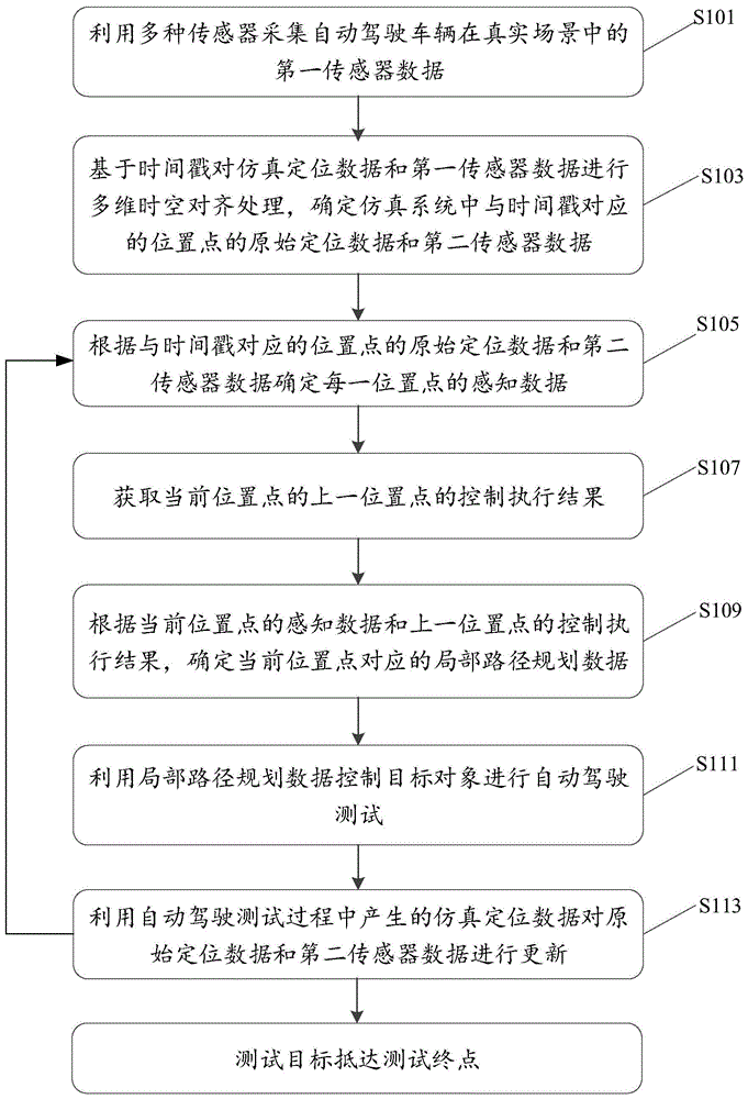
Referring to fig. 1, which is a flow chart illustrating an automated driving simulation method provided in an embodiment of the present application, the present specification provides the method operation steps as described in the embodiment or the flow chart, but more or less operation steps may be included based on conventional or non-inventive labor. The step sequence listed in the embodiment is only one of the execution sequences of a plurality of steps, does not represent the only execution sequence, and can be executed according to the method sequence shown in the embodiment or the attached drawings when the automatic driving full module needs to be subjected to simulation test. Specifically, as shown in fig. 1, the method includes:
s101: first sensor data of an autonomous vehicle in a real scene is collected using a plurality of sensors.
Specifically, a real object is placed in a real scene to run, and a plurality of sensors are used for collecting first sensor data in the running process. The real object may include a vehicle driven by a driver or an autonomous vehicle, the first sensor data includes data recorded according to a travel time trajectory, and the time trajectory is a set in which a plurality of timestamps are arranged in order.
In some embodiments, the plurality of sensors may include: ultrasonic radar, laser radar, camera and millimeter wave radar. The ultrasonic radar can carry out three-dimensional mapping on objects with short distance. The laser radar can detect static and dynamic objects and acquire high-resolution geometric figures, range images and speed images of the detected objects. The camera may capture images or video. Millimeter-wave radars may detect and locate objects using radio waves.
S103: and performing multidimensional space-time alignment processing on the simulation positioning data and the first sensor data based on the timestamp, and determining the original positioning data and the second sensor data of the position point corresponding to the timestamp in the simulation system.
The first sensor data are data collected in a real scene, and the simulation positioning data are positioning data in a virtual scene of the simulation system. Specifically, the multidimensional time-space alignment processing includes establishing a one-to-one correspondence between timestamps in the real scene and position points in the simulation system. And extracting data corresponding to the required position point from the simulation positioning data and the first sensor data according to the one-to-one correspondence relationship between the timestamp in the real scene and the position point in the simulation system to obtain the original positioning data and the second sensor data.
S105: and determining the perception data of each position point according to the original positioning data of the position point corresponding to the time stamp and the second sensor data.
Specifically, the raw positioning data and the second sensor data can be processed by deep learning neural network operation, sensor fusion and coordinate transformation algorithm operation to obtain the perception data. The perception data includes data such as the direction or distance of the target object relative to the obstacle in absolute coordinates.
S107: and acquiring a control execution result of a position point above the current position point.
Specifically, at a position point above the current position point, the regulation and control module sends a control command, and the target object performs driving processing in response to the control command to obtain a control execution result of the position point, where the control execution result may include control execution results such as a steering angle, a brake deceleration, and an accelerator acceleration.
In some embodiments, as shown in fig. 2, the method further comprises:
s2071: and (5) constructing a dynamic model.
Specifically, the dynamic model may characterize the force versus motion relationship acting on the target object, such as longitudinal speed control, by controlling tire rotational speed; lateral course control, by controlling tire rotation angle, etc. And the dynamic model is constructed and can be used for analyzing the smoothness of vehicle driving and the stability of the vehicle executing the control command.
S2073: and inputting the control instruction of the previous position point of the current position point into a dynamic model for dynamic processing to obtain a control execution result of the previous position point of the current position point.
In the embodiment of the present disclosure, the input control command may be calculated by using a dynamic model, and the output result is the control execution result of the position point. At the initial point of the simulation, the inputs to the dynamical model also include the starting position of the target object, which may be set manually. The starting position of the target object mainly includes the starting position data of the target object in the UTM (universal TransverseMercator), and the corresponding heading angle. The timestamp corresponding to the start position is the first timestamp ordered in time.
According to the embodiment, the dynamic model is constructed, the control instruction is input into the dynamic model, the control execution result can be directly obtained, the processing efficiency is high, the dynamic model can be conveniently modified according to actual requirements, and the maneuverability is high.
In a further embodiment, as shown in fig. 3, the method further comprises:
s3071: and (5) building a vehicle on a ring rack.
S3073: and inputting a control instruction of the previous position point of the current position point into the vehicle to perform simulation operation on the ring rack to obtain a control execution result of the previous position point of the current position point.
In the above embodiment, the vehicle is in a state where the ring stand is close to the actual vehicle, and the control instruction is executed by the vehicle in the ring stand, and the reliability of the obtained control execution result is high.
S109: and determining local path planning data corresponding to the current position point according to the sensing data of the current position point and the control execution result of the previous position point.
And the planning and controlling module carries out planning and decision on the expected data of the current position point according to the sensing data of the current position point and the control execution result of the previous position point, so that the local path planning data corresponding to the current position point is determined. Specifically, lane-changing behaviors and following behaviors, such as lane-changing intention, lane-changing feasibility analysis, target lane selection, lane keeping and the like, can be decided by the perception data of the current position point. And combining the control execution result of the previous position point, such as the steering angle, the accelerator acceleration, the brake deceleration and other states of the vehicle, and processing the control based on the driving safety, the driving efficiency and the riding comfort so as to generate local path planning data such as a desired steering wheel angle, a desired acceleration and the like.
S111: and controlling the target object to perform automatic driving test by using the local path planning data.
Specifically, a control command is generated based on the local path planning data, and an automatic driving test is performed on the target object. The automatic driving test can be used for carrying out simulation verification on a whole module and can also be used for checking the parameter setting problem of a single module.
S113: and updating the original positioning data and the second sensor data by using the simulated positioning data generated in the automatic driving test process, and repeating the steps from S105 to S113 until the test target reaches the test end point.
Specifically, the test endpoint is an endpoint in the virtual environment of the simulation system, and meanwhile, the test endpoint corresponds to an endpoint at which the vehicle is driven to arrive in the real scene. The sensor data of the end position in the virtual environment of the simulation system should be the sensor data of the driving end of the vehicle in the real scene. The simulation positioning data generated in the automatic driving test process is used for updating the original positioning data and the second sensor data, and then the original positioning data and the second sensor data are used as the input of the sensing module, so that the closed loop of the simulation system can be realized, and a target object in the virtual environment of the simulation system can drive to a test terminal along a planned path.
In the embodiment, the first sensor data of the automatic driving vehicle in the real scene are acquired by using various sensors, and the data packet management module performs multidimensional space-time alignment processing on the simulation positioning data and the first sensor data based on the timestamp to determine the original positioning data and the second sensor data of the position point corresponding to the timestamp in the simulation system; the sensing module determines sensing data of each position point according to the original positioning data of the position point corresponding to the timestamp and the second sensor data; acquiring a control execution result of a position point above a current position point; the control module determines local path planning data corresponding to the current position point according to the sensing data of the current position point and the control execution result of the previous position point, so that closed-loop test of a target object by adopting data acquired in the real world can be realized, and verification test of a whole module in the simulation system can be realized.
In a further embodiment, as shown in fig. 4, the method comprises:
s401: first sensor data of an autonomous vehicle in a real scene is collected using a plurality of sensors.
S4021: local path planning data is acquired.
Specifically, the local path planning data includes initial local path planning data and local path planning data generated in an automated driving simulation.
S4023: simulated positioning data is extracted from the local path planning data.
In general, the schedule control module sends the local path planning data to the data packet management module, and the data packet management module stores the local path planning data. The data packet management module can extract the simulation positioning data from the local path planning data. Specifically, a flener coordinate system may be used to represent the local path, and the S value and the path identification data of the flener coordinate system are extracted from the local path planning data. The flener coordinate system is with the target object itself as the origin, and the coordinate axes are perpendicular to each other, where the longitudinal S-axis is along the direction of the reference line and the transverse D-axis is normal along the reference line. In practical application, the center line of the road may be used as a reference line, and the S value of the flener coordinate system is the distance between the target object and the reference line on the longitudinal S axis. The simulation positioning data extracted from the local path planning data are S value and path identification data of a Ferner coordinate system.
S403: and performing multidimensional space-time alignment processing on the simulation positioning data and the first sensor data based on the timestamp, and determining original positioning data and second sensor data of a position point corresponding to the timestamp in the simulation system.
S405: and determining the perception data of each position point according to the original positioning data of the position point corresponding to the time stamp and the second sensor data.
S407: and acquiring a control execution result of a position point above the current position point.
S409: and determining local path planning data corresponding to the current position point according to the sensing data of the current position point and the control execution result of the previous position point.
S411: and controlling the target object to perform automatic driving test by using the local path planning data.
S413: and updating the original positioning data and the second sensor data by using the simulated positioning data generated in the automatic driving test process, and repeating the steps from S405 to S413 until the test target reaches the test end point.
In still other embodiments, as shown in FIG. 5, the method includes:
s501: first sensor data of an autonomous vehicle in a real scene is collected using a plurality of sensors.
S503: and performing multidimensional space-time alignment processing on the simulation positioning data and the first sensor data based on the timestamp, and determining original positioning data and second sensor data of a position point corresponding to the timestamp in the simulation system.
S504: and the high-precision map module acquires high-precision map data.
S505: and the sensing module determines the sensing data of each position point according to the original positioning data of the position point corresponding to the timestamp, the second sensor data and the high-precision map data.
S507: and acquiring a control execution result of a position point above the current position point.
S509: and the planning and control module determines local path planning data corresponding to the current position point according to the sensing data of the current position point and the control execution result of the previous position point.
S511: and controlling the target object to perform automatic driving test by using the local path planning data.
S513: and updating the original positioning data and the second sensor data by using the simulated positioning data generated in the automatic driving test process, and repeating the steps from S105 to S111 until the test target reaches the test end point.
In the above-described embodiment, the road traffic information elements in the high-precision map data are rich and detailed, and can reflect the relative position between the target object and the surrounding environment. High-precision map data are added on the basis of the original positioning data and the second sensor data, and the sensing module can obtain more accurate and detailed sensing data, so that the driving safety and reliability of the automatic driving vehicle are improved.
In some other embodiments, before the executing the result according to the sensing data of the current position point and the control of the previous position point, the method further comprises:
and the data processing module performs data encapsulation on the simulation positioning data and the control execution result by using a preset protocol to obtain a data encapsulation packet, and the regulation and control module can receive the encapsulated data.
In another aspect, the present application further provides an embodiment of an automatic driving simulation system, as shown in fig. 6, the system 600 includes:
the sensor data acquisition module 601 is used for acquiring first sensor data of the automatic driving vehicle in a real scene by using various sensors;
a multidimensional time-space alignment processing module 603, configured to perform multidimensional time-space alignment processing on the simulation positioning data and the first sensor data based on the timestamp, and determine original positioning data and second sensor data of a position point in the simulation system corresponding to the timestamp;
a sensing module 605, configured to determine sensing data of each location point according to the raw positioning data of the location point corresponding to the timestamp and the second sensor data;
a dynamics module 607, configured to control the target object to perform an automatic driving test by using the local path planning data, and obtain a control execution result of a position point above the current position point;
the planning and control module 609 is configured to determine local path planning data corresponding to the current position point according to the sensing data of the current position point and the control execution result of the previous position point;
the data packet management module 611 is configured to update the original positioning data and the second sensor data with the simulated positioning data generated in the automatic driving test process.
In some other embodiments, as shown in fig. 7, the system 600 further comprises:
and a high-precision map module 604 for generating high-precision map data.
In some other embodiments, as shown in fig. 8, the system 600 further comprises:
the data processing module 608 is configured to perform data encapsulation on the simulation positioning data and the control execution result by using a preset protocol to obtain a data encapsulation packet, and send the data encapsulation packet to the regulation and control module.
In another aspect, the present application further provides an automatic driving simulation medium, which includes a processor and a memory, where at least one instruction, at least one program, a set of codes, or a set of instructions is stored in the memory, and the at least one instruction, the at least one program, the set of codes, or the set of instructions is loaded and executed by the processor to implement the automatic driving simulation method.
The foregoing description has disclosed fully embodiments of the present application. It should be noted that those skilled in the art can make modifications to the embodiments of the present application without departing from the scope of the claims of the present application. Accordingly, the scope of the claims of the present application is not to be limited to the particular embodiments described above.
All the embodiments in the present specification are described in a progressive manner, and the same and similar parts among the embodiments are referred to each other, and each embodiment focuses on the differences from other embodiments. In particular, as for the apparatus, system and server embodiments, since they are substantially similar to the method embodiments, the description is relatively simple, and reference may be made to some descriptions of the method embodiments for relevant points.
It will be understood by those skilled in the art that all or part of the steps for implementing the above embodiments may be implemented by hardware, or may be implemented by a program instructing relevant hardware, where the program may be stored in a computer-readable storage medium, and the above-mentioned storage medium may be a read-only memory, a magnetic disk or an optical disk, etc.
The above description is only for the purpose of illustrating the preferred embodiments of the present invention and should not be taken as limiting the scope of the present invention, which is intended to cover any modifications, equivalents, improvements, etc. within the spirit and scope of the present invention.