CN111578944A - Underwater glider positioning system and method based on single beacon - Google Patents
Underwater glider positioning system and method based on single beacon Download PDFInfo
- Publication number
- CN111578944A CN111578944A CN202010440777.5A CN202010440777A CN111578944A CN 111578944 A CN111578944 A CN 111578944A CN 202010440777 A CN202010440777 A CN 202010440777A CN 111578944 A CN111578944 A CN 111578944A
- Authority
- CN
- China
- Prior art keywords
- positioning
- beacon
- underwater glider
- time
- underwater
- Prior art date
- Legal status (The legal status is an assumption and is not a legal conclusion. Google has not performed a legal analysis and makes no representation as to the accuracy of the status listed.)
- Granted
Links
Images

Classifications
-
- G—PHYSICS
- G01—MEASURING; TESTING
- G01C—MEASURING DISTANCES, LEVELS OR BEARINGS; SURVEYING; NAVIGATION; GYROSCOPIC INSTRUMENTS; PHOTOGRAMMETRY OR VIDEOGRAMMETRY
- G01C21/00—Navigation; Navigational instruments not provided for in groups G01C1/00 - G01C19/00
- G01C21/20—Instruments for performing navigational calculations
- G01C21/203—Instruments for performing navigational calculations specially adapted for water-borne vessels
-
- G—PHYSICS
- G01—MEASURING; TESTING
- G01C—MEASURING DISTANCES, LEVELS OR BEARINGS; SURVEYING; NAVIGATION; GYROSCOPIC INSTRUMENTS; PHOTOGRAMMETRY OR VIDEOGRAMMETRY
- G01C21/00—Navigation; Navigational instruments not provided for in groups G01C1/00 - G01C19/00
- G01C21/005—Navigation; Navigational instruments not provided for in groups G01C1/00 - G01C19/00 with correlation of navigation data from several sources, e.g. map or contour matching
-
- G—PHYSICS
- G01—MEASURING; TESTING
- G01S—RADIO DIRECTION-FINDING; RADIO NAVIGATION; DETERMINING DISTANCE OR VELOCITY BY USE OF RADIO WAVES; LOCATING OR PRESENCE-DETECTING BY USE OF THE REFLECTION OR RERADIATION OF RADIO WAVES; ANALOGOUS ARRANGEMENTS USING OTHER WAVES
- G01S19/00—Satellite radio beacon positioning systems; Determining position, velocity or attitude using signals transmitted by such systems
- G01S19/01—Satellite radio beacon positioning systems transmitting time-stamped messages, e.g. GPS [Global Positioning System], GLONASS [Global Orbiting Navigation Satellite System] or GALILEO
- G01S19/13—Receivers
- G01S19/14—Receivers specially adapted for specific applications
-
- G—PHYSICS
- G01—MEASURING; TESTING
- G01S—RADIO DIRECTION-FINDING; RADIO NAVIGATION; DETERMINING DISTANCE OR VELOCITY BY USE OF RADIO WAVES; LOCATING OR PRESENCE-DETECTING BY USE OF THE REFLECTION OR RERADIATION OF RADIO WAVES; ANALOGOUS ARRANGEMENTS USING OTHER WAVES
- G01S5/00—Position-fixing by co-ordinating two or more direction or position line determinations; Position-fixing by co-ordinating two or more distance determinations
- G01S5/18—Position-fixing by co-ordinating two or more direction or position line determinations; Position-fixing by co-ordinating two or more distance determinations using ultrasonic, sonic, or infrasonic waves
Landscapes
- Engineering & Computer Science (AREA)
- Radar, Positioning & Navigation (AREA)
- Remote Sensing (AREA)
- Physics & Mathematics (AREA)
- General Physics & Mathematics (AREA)
- Automation & Control Theory (AREA)
- Computer Networks & Wireless Communication (AREA)
- Position Fixing By Use Of Radio Waves (AREA)
Abstract
The invention discloses an underwater glider positioning system and method based on a single beacon. The positioning system comprises a positioning acoustic receiving module, a positioning processing module, a pressure sensor, an attitude sensor and a satellite receiving module in the underwater glider, and a positioning beacon deployed on the sea bottom or the sea surface. Firstly, a single positioning beacon sends a positioning message containing longitude and latitude and elevation information at a fixed time interval, an underwater glider monitors and analyzes the positioning message, a state vector, a measurement vector, a corresponding state equation and a corresponding measurement equation are established by combining message information and node attitude information, and the estimated position of the underwater mobile node is calculated by using extended Kalman filtering. When the method is used for positioning the underwater glider, the underwater glider is not required to be kept synchronous with a beacon clock, and a speedometer is not required to be equipped.
Description
Technical Field
The invention belongs to the technical field of positioning, and relates to a single-beacon-based underwater glider positioning system and method.
Background
In recent years, exploration of marine resources, marine environment monitoring, research and development of underwater equipment and the like become hot directions. Underwater robots, such as Autonomous Underwater Vehicles (AUV), Underwater Gliders (UG), Remote Operated Underwater Robots (ROV), etc., are increasingly used in marine environment monitoring and Underwater object detection, and such Underwater devices often need to be maneuvered to a designated area to perform a corresponding Underwater task. Therefore, the positioning and tracking of the underwater robot is one of the supporting technologies of the robot in scientific research and engineering application.
Because electromagnetic wave signals are greatly attenuated in seawater, a relatively mature positioning system (such as a global positioning system in the united states, a Beidou positioning system in China) on land is not suitable for positioning an underwater robot. The attenuation of the acoustic signal in seawater is small, and the underwater acoustic signal is a main carrier for underwater information transmission and is often used in the field of positioning and tracking of underwater equipment.
On the basis, an underwater equipment positioning method and an underwater equipment positioning system represented by a long baseline, a short baseline and an ultra-short baseline are developed. The long baseline positioning system can be used for autonomous positioning of underwater equipment, a sensor array is arranged on the seabed, and a response mechanism is adopted for ranging, so that higher positioning accuracy is obtained, but an underwater acoustic response device needs to be deployed in a fixed water area, and the calibration difficulty of the node position of a responder is high, so that the modern price of the responder is higher. The short-baseline underwater sound positioning system needs to arrange a sensor array on a carrier platform, and underwater equipment is provided with a transponder and can be positioned, but the underwater equipment cannot be positioned automatically. The ultra-short baseline underwater acoustic positioning system needs to arrange an acoustic baseline array on a carrier platform, an underwater device is provided with a transponder, and the underwater device is positioned by adopting a response mechanism, but the autonomous positioning of the underwater device cannot be realized. Meanwhile, the ultra-short baseline positioning system has a complicated calibration problem. On the basis, a plurality of positioning schemes in a combined form are provided, and the accuracy of the long baseline and the portability of the ultra-short baseline are both achieved. However, the underwater acoustic positioning methods all require a transponder to complete distance measurement or angle of arrival measurement, and cannot realize energy-saving and concealed positioning of underwater equipment.
An underwater robot positioning method based on multiple beacons is developed on the basis of underwater acoustic ranging. And performing information interaction by using the plurality of beacons and the underwater robot to realize ranging, and combining the positions of the plurality of beacons and ranging information to realize position solution of the underwater robot. According to different working modes, the underwater robot can actively send a positioning request to the beacon and also can passively receive a positioning message broadcasted by the beacon to acquire ranging information. Through retrieval, the Chinese patent application No. CN201711371839.6 discloses an autonomous positioning method for an underwater mobile node based on Beidou beacons, 3 beacons on the sea surface form a positioning array, positioning messages are synchronously broadcast, an underwater robot passively monitors the messages, and position calculation is completed after 3 positioning messages are received; chinese patent application No. CN201910635423.3 discloses a multi-beacon-based ultra-short baseline calibration system and calibration method, which accurately calibrate an integrally mounted ultra-short baseline transducer through multiple beacons.
Compared with an underwater robot positioning method based on multiple beacons, the underwater robot positioning technology based on the single positioning beacon is a new research direction of underwater acoustic positioning. The underwater robot with the positioning mode only needs to utilize positioning message information sent by one beacon node, and the acoustic ranging positioning equipment and the robot platform motion sensor are used in a combined mode, so that the self position of the underwater robot is estimated. At present, some underwater robot positioning and tracking methods based on single positioning beacons exist. Through retrieval, the chinese patent application No. CN201710599165.9 and the chinese patent application No. CN201710599155.5 respectively disclose an AUV positioning and tracking method based on virtual beacons and a single beacon ranging and positioning method based on virtual transceiving beacons. The limitation of these two tracking methods is that the node location is performed by using the slant distance from the location beacon to the AUV, which requires that the node and the beacon maintain strict clock synchronization. In addition, there is a positioning and tracking method based on a single-beacon underwater robot using transmission time for sequential filtering, which is limited in that the nodes are required to keep clock synchronization with the beacons and the speed of the mobile nodes needs to be acquired in real time.
The existing underwater sound positioning method of the underwater robot mostly has the following problems:
1. the underwater robot and the beacon need to keep clocks synchronous. In a complex underwater environment, clock drift of the underwater robot is difficult to compensate, and accurate synchronization with a beacon node cannot be maintained, so that a measurement and calculation link is greatly influenced.
2. The underwater robot needs to be equipped with a transponder in a responsive manner. For energy saving, some underwater robots are not equipped with a signal transmitting device and cannot transmit a response signal. In addition, in the scene of special safety requirements, the underwater node cannot send signals due to concealment.
3. Underwater robots need to be equipped with doppler velocimeters. For miniaturized underwater robotic platforms, high accuracy doppler velocimeters are expensive and finding suitable ways to reduce the use of or replace the velocimeter measurements is essential.
Therefore, in the case that the clocks are not synchronous and the underwater robot does not adopt a response mechanism, it is very necessary to realize the positioning of the underwater robot.
Disclosure of Invention
One object of the present invention is to provide a positioning system for underwater gliders without a speedometer, in case the clock of the underwater glider is not synchronized with the beacon, and no response mechanism is used.
The positioning system comprises a positioning acoustic receiving module, a positioning processing module, a pressure sensor, an attitude sensor, a satellite receiving module and a positioning beacon deployed on the sea bottom or the sea surface, wherein the positioning acoustic receiving module, the positioning processing module, the pressure sensor, the attitude sensor and the satellite receiving module are arranged in an underwater glider. The positioning acoustic receiving module comprises a hydrophone and an underwater acoustic receiving module and is used for receiving the positioning message from the positioning beacon and recording the arrival time of the positioning message; the pressure sensor is used for acquiring the depth information of the underwater glider; the attitude sensor is used for acquiring real-time attitude information of the glider; the positioning processing module is used for executing a positioning algorithm and estimating the position of the underwater glider; the underwater glider floats out of the water surface when beginning to glide once or ending to glide once, and the satellite receiving module is used for correcting the initial position of the underwater glider at the moment.
If the positioning beacon is a subsea beacon deployed on the seafloor, the subsea beacon contains an acoustic system and a positioning acoustic transceiver. The acoustic system is used for calibrating the position of the submarine beacon; the positioning acoustic transceiver is used for broadcasting positioning messages. After the submarine beacon is laid, the submarine beacon is firstly in a beacon position calibration mode, after the submarine beacon acquires the position of the submarine beacon, the submarine beacon is switched to a beacon working mode, and the positioning message is broadcast at fixed time intervals.
If the positioning beacon is a sea beacon deployed on the sea surface, the sea beacon comprises a satellite signal receiver and a positioning acoustic transceiver. The satellite signal receiver is used for receiving satellite signals and acquiring the real-time position of the sea surface beacon; the positioning acoustic transceiver is used for broadcasting positioning messages. After the sea surface beacon is laid out, the sea surface beacon directly enters a beacon working mode, the position information of the beacon is obtained in real time through a satellite signal receiver, and a positioning message is broadcast at a fixed time interval.
The positioning message has 128 bits, and sequentially comprises: a 12-bit synchronization code SYN (synchronization sequence number) for indicating the start bit of the positioning packet; a 4-bit type code TYP for indicating the type of the positioning message; an 8-bit beacon number ADR for indicating which beacon the positioning message is sent by; an 8-bit reserved bit RES for a reserved bit of a control function; 32 bits of longitude information LON, 32 bits of latitude information LAT, 16 bits of elevation (depth) information HEI; a 16-bit error correction redundancy bit FCC for frame error correction of the message.
Another object of the present invention is to provide a method for positioning an underwater glider using the above system.
The method comprises the following steps:
step (1), a positioning beacon deployed on the sea bottom or sea surface periodically sends a positioning message, specifically: the positioning beacon composes the information containing the longitude, latitude and elevation of the positioning beacon into a positioning message according to a specified positioning message format, and broadcasts the positioning message at a fixed time interval;
step (2), intercepting and positioning messages of the underwater glider, which is specifically as follows: the underwater glider receives the positioning message sent by the positioning beacon through the positioning acoustic receiving module, and simultaneously records the reaching time t when the nth positioning message reaches the positioning acoustic receiving modulen(ii) a The received positioning message and the arrival time thereof are sent to a positioning processing module of the underwater glider;
and (3) finishing the estimation of the position of the underwater glider by a positioning processing module, wherein the specific steps are as follows:
(3-1) the positioning processing module analyzes the positioning message to obtain longitude L, latitude B and elevation H of the positioning beacon;
(3-2) reading the current attitude information of the underwater glider from the attitude sensor by the positioning processing module; underwater glider at tnThe attitude information acquired at the moment includes: included angle theta between moving direction of underwater glider and horizontal planen(ii) a The angle between the horizontal component of the direction of travel of the underwater glider and the east-ward direction, i.e. the heading angle Depth z of underwater glidern;
(3-3) the positioning processing module constructs a measurement vector and a state vector according to the attitude information; t is tnMoment underwater glider measurement vector Ψn=tnState vector sn=[xnynτn]T,xnRepresents the X-axis coordinate of the horizontal position of the underwater glider, yn represents the Y-axis coordinate of the horizontal position of the underwater glider, and taunIndicating an underwater glider and a positioning beacon at tnThe clock drift factor of the time specifies that the positive north direction is the positive Y-axis direction, the positive east direction is the positive X-axis direction, and T represents transposition;
(3-4) the positioning processing module establishes a measurement equation and a state equation according to the conversion relation between the measurement vector and the state vector; the method comprises the following steps:
the longitude, latitude and elevation (L, B, H) of the positioning beacon are converted into Cartesian coordinates (X, Y, Z) by the positioning processing module; the measurement equation is: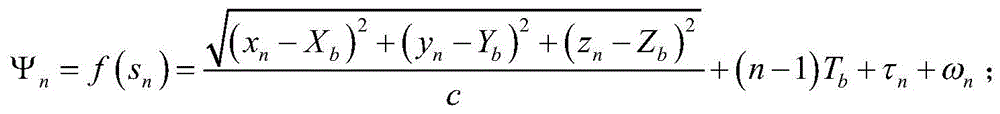 where c is the effective speed of sound, ωnRepresenting measurement noise as white Gaussian noise, (X)b,Yb,Zb) Coordinates representing a positioning beacon, TbA message transmission time interval;
at tn-1Time tnWithin time, vx,n=vx,n-1+vx,n,vy,n=vy,n-1+vy,n(ii) a Wherein v isx,nAnd vy,nRespectively represent tnComponents of the X-axis and Y-axis of the velocity of the underwater glider at the moment;vx,nandvy,nrespectively represent tn-1Time and tnSpeed errors in the X-axis and Y-axis directions at two adjacent moments in time; t is tn-1Time tnTime interval at of timen=tn-tn-1;
To obtain tn-1Time tnHorizontal position (x) of underwater glider at timen,yn);
xn=xn-1+vx,n·Δtn+x,n,yn=yn-1+vy,n·Δtn+y,n(ii) a Wherein,x,nandy,nrespectively represent tn-1Time and tnPosition estimation errors in the X-axis and Y-axis directions at two adjacent moments in time;
for tn-1Time tnTime of day, depth change Δ z of underwater glidern=zn-zn-1Average submergence speed in the time period From the attitude of the underwater gliderInformation, the X-axis and Y-axis components of the underwater glider velocity are expressed as:

at tn-1Time tnWithin a time of day, τn=τn-1+τ,n,τ,nFor underwater gliders and positioning beacons at tn-1Time and tnClock drift errors at two adjacent moments in time;
the state equation is: sn=Αnsn-1+Bnun-1+n(ii) a Wherein the transfer matrix Control matrix
 Velocity vector
 Error vector
(3-5) the positioning processing module completes positioning calculation according to the measurement vector, the state vector, the measurement equation and the state equation to obtain a positioning result; the method comprises the following steps:
to the measurement equation Carrying out linearization treatment to obtain snJacobi matrix (Jacobi) Fn:
 Wherein, tnDistance from underwater glider to positioning beacon at moment
Performing position estimation by using extended Kalman filtering, wherein the position estimation comprises state prediction and state updating cyclic processing;
when one-time gliding starts or finishes, the underwater glider floats out of the water surface, the initial position correction is carried out through the satellite receiving module, and then the state prediction and the state updating are carried out;
the state prediction is represented as:
 and
and respectively represent state vectors snThe predicted value and the updated value of (c);
the state update is represented as: wherein,
kalman gain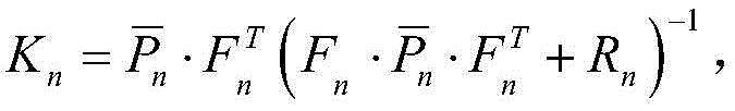
 Covariance matrix, R, predicted for state variablesnA covariance matrix which is a measurement vector;


By updated values of state vectors Obtaining the horizontal position of the underwater glider after filtering treatment
 Combined depth z of underwater glidernThree-dimensional coordinates of underwater gliders
 Then converting the coordinates into longitude and latitude coordinates
 And then the underwater glider positioning is completed.
The method can realize the positioning of the underwater glider by utilizing the positioning message broadcasted by the single positioning beacon and the attitude information of the underwater glider, and the structure of the positioning system is simpler. Compared with the calculated position in the underwater glider, the method can improve the positioning precision of the underwater glider. The underwater glider passively listens for the positioning message, a positioning request does not need to be sent to the positioning beacon, the whole positioning process is energy-saving, and certain secrecy is achieved. In addition, a certain sea area can be covered by using a single positioning beacon, and a plurality of beacons can cover a larger positioning area by adopting the arrangement mode of the single beacon, so that the method has stronger economy.
Drawings
FIG. 1 is a schematic flow chart of the extended Kalman filtering in the method of the present invention.
Detailed Description
For a more detailed explanation of the invention, reference is made to the accompanying drawings, which are not intended to be limiting, wherein structures are omitted or scaled differently than actual dimensions, for illustration purposes only.
The underwater glider without a speed meter realizes positioning through the following positioning system.
The positioning system comprises a positioning acoustic receiving module, a positioning processing module, a pressure sensor, an attitude sensor, a satellite receiving module and a positioning beacon deployed on the sea bottom or the sea surface, wherein the positioning acoustic receiving module, the positioning processing module, the pressure sensor, the attitude sensor and the satellite receiving module are arranged in the underwater glider. The positioning acoustic receiving module comprises a hydrophone and an underwater acoustic receiving module and is used for receiving the positioning message from the positioning beacon and recording the arrival time of the positioning message; the pressure sensor is used for acquiring the depth information of the underwater glider; the attitude sensor is used for acquiring real-time attitude information of the underwater glider; the positioning processing module is used for executing a positioning algorithm and estimating the position of the underwater glider; the underwater glider floats out of the water surface when beginning to glide once or ending to glide once, and the satellite receiving module is used for carrying out initial position correction on the underwater glider at the moment.
If the positioning beacon is a subsea beacon deployed on the seafloor, the subsea beacon contains an acoustic system and a positioning acoustic transceiver. The acoustic system is used for calibrating the position of the submarine beacon; the positioning acoustic transceiver is used for broadcasting positioning messages. After the submarine beacon is laid, the submarine beacon is firstly in a beacon position calibration mode, after the submarine beacon acquires the position of the submarine beacon, the submarine beacon is switched to a beacon working mode, and the positioning message is broadcast at fixed time intervals.
If the positioning beacon is a sea beacon deployed on the sea surface, the sea beacon comprises a satellite signal receiver and a positioning acoustic transceiver. The satellite signal receiver is used for receiving satellite signals and acquiring the real-time position of the sea surface beacon; the positioning acoustic transceiver is used for broadcasting positioning messages. After the sea surface beacon is laid out, the sea surface beacon directly enters a beacon working mode, the position information of the beacon is obtained in real time through a satellite signal receiver, and a positioning message is broadcast at a fixed time interval.
The positioning message has 128 bits, and sequentially comprises: a synchronization code SYN (synchronization sequence number) of 12 bits for indicating the start bit of the positioning packet; a 4-bit type code TYP for indicating the type of the positioning message; an 8-bit beacon number ADR for indicating which beacon the positioning message is sent by; an 8-bit reserved bit RES for a reserved bit of a control function; 32 bits of longitude information LON, 32 bits of latitude information LAT, 16 bits of elevation (depth) information HEI; a 16-bit error correction redundancy bit FCC for frame error correction of the message.
The positioning beacon broadcasts a positioning message at fixed time intervals, the underwater glider monitors the positioning message of the submarine single beacon, and positioning is realized by combining attitude information. The specific method comprises the following steps:
step (1), a positioning beacon deployed on the sea bottom or sea surface periodically sends a positioning message, specifically: and the positioning beacon composes the information containing the longitude, latitude and elevation of the positioning beacon into a positioning message according to a specified positioning message format, and broadcasts the positioning message at a fixed time interval.
Step (2), intercepting and positioning messages of the underwater glider, which is specifically as follows: the underwater glider receives the positioning message sent by the positioning beacon through the positioning acoustic receiving module, and simultaneously records the reaching time t when the nth positioning message reaches the positioning acoustic receiving modulen(ii) a And the received positioning message and the arrival time thereof are sent to a positioning processing module of the underwater glider.
And (3) finishing the estimation of the position of the underwater glider by a positioning processing module, wherein the specific steps are as follows:
(3-1) the positioning processing module analyzes the positioning message to obtain longitude L, latitude B and elevation H of the positioning beacon;
(3-2) reading the current attitude information of the underwater glider from the attitude sensor by the positioning processing module; underwater glider at tnThe attitude information acquired at the moment includes: included angle theta between moving direction of underwater glider and horizontal planen(ii) a The angle between the horizontal component of the direction of travel of the underwater glider and the east-ward direction, i.e. the heading angle Depth z of underwater glidern;
(3-3) the positioning processing module constructs a measurement vector and a state vector according to the attitude information; t is tnMoment underwater glider measurement vector Ψn=tnState vector sn=[xnynτn]T,xnX-axis coordinate, y, representing horizontal position of underwater glidernIndicating underwater slippageHorizontal position Y-axis coordinate of aircraft, taunIndicating an underwater glider and a positioning beacon at tnThe clock drift factor of the time specifies that the positive north direction is the positive Y-axis direction, the positive east direction is the positive X-axis direction, and T represents transposition;
(3-4) the positioning processing module establishes a measurement equation and a state equation according to the conversion relation between the measurement vector and the state vector;
the longitude, latitude and elevation (L, B, H) of the positioning beacon are converted into Cartesian coordinates (X, Y, Z) by the positioning processing module; the measurement equation is: where c is the effective speed of sound, ωnRepresenting measurement noise as white Gaussian noise, (X)b,Yb,Zb) Coordinates representing a positioning beacon, TbA message transmission time interval;
at tn-1Time tnWithin time, vx,n=vx,n-1+vx,n,vy,n=vy,n-1+vy,n(ii) a Wherein v isx,nAnd vy,nRespectively represent tnComponents of the X-axis and Y-axis of the velocity of the underwater glider at the moment;vx,nandvy,nrespectively represent tn-1Time and tnSpeed errors in the X-axis and Y-axis directions at two adjacent moments in time; t is tn-1Time tnTime interval at of timen=tn-tn-1;
To obtain tn-1Time tnHorizontal position (x) of underwater glider at timen,yn);
xn=xn-1+vx,n·Δtn+x,n,yn=yn-1+vy,n·Δtn+y,n(ii) a Wherein,x,nandy,nrespectively represent tn-1Time and tnPosition estimation errors in the X-axis and Y-axis directions at two adjacent moments in time;
because the underwater glider is not provided with a speedometer, the horizontal movement cannot be directly obtained in a measuring modeSpeed; for tn-1Time tnTime of day, depth change Δ z of underwater glidern=zn-zn-1Average submergence speed in the time period
From the attitude information of the underwater glider, the X-axis and Y-axis components of the underwater glider velocity are represented as:

at tn-1Time tnWithin a time of day, τn=τn-1+τ,n,τ,nFor underwater gliders and positioning beacons at tn-1Time and tnClock drift errors at two adjacent moments in time;
the state equation is: sn=Αnsn-1+Bnun-1+n(ii) a Wherein the transfer matrix Control matrix
 Velocity vector
 Error vector
(3-5) the positioning processing module completes positioning calculation according to the measurement vector, the state vector, the measurement equation and the state equation to obtain a positioning result; the method comprises the following steps:
to the measurement equation Carrying out linearization treatment to obtain snJacobi matrix (Jacobi) Fn:
 Wherein, tnDistance from underwater glider to positioning beacon at moment
Performing position estimation by using extended Kalman filtering, wherein the position estimation comprises state prediction and state updating cyclic processing;
when one-time gliding starts or finishes, the underwater glider floats out of the water surface, the initial position correction is carried out through the satellite receiving module, and then the state prediction and the state updating are carried out, as shown in figure 1;
the state prediction is represented as:
 and
and respectively represent state vectors snThe predicted value and the updated value of (c);
the state update is represented as: wherein,
kalman gain
 Covariance matrix, R, predicted for state variablesnA covariance matrix which is a measurement vector;


By updated values of state vectors Obtaining the horizontal position of the underwater glider after filtering treatment
 Combined depth z of underwater glidernThree-dimensional coordinates of underwater gliders
 Then converting the coordinates into longitude and latitude coordinates
 And then the underwater glider positioning is completed.
Carrying out algorithm simulation: the longitude and latitude coordinates of the submarine single beacon are (111.82101 degrees E,18.04949 degrees N), and the submarine single beacon is arranged on the seabed with the depth of 1000 meters. The positioning beacon is set to broadcast positioning messages at 8 second intervals. An underwater glider moves within the coverage of the positioning message. The simulation parameters are set as follows:

setting the motion track of the underwater glider to carry out algorithm simulation, and obtaining the three-dimensional coordinates of the underwater glider after filtering processing by utilizing the algorithm
Calculating the horizontal position of the underwater glider after filtering And true position (x) of underwater glidern,yn) Positioning error of
Claims (3)


Priority Applications (1)
| Application Number | Priority Date | Filing Date | Title |
|---|---|---|---|
| CN202010440777.5A CN111578944B (en) | 2020-05-22 | 2020-05-22 | Underwater glider positioning method based on single beacon |
Applications Claiming Priority (1)
| Application Number | Priority Date | Filing Date | Title |
|---|---|---|---|
| CN202010440777.5A CN111578944B (en) | 2020-05-22 | 2020-05-22 | Underwater glider positioning method based on single beacon |
Publications (2)
| Publication Number | Publication Date |
|---|---|
| CN111578944A true CN111578944A (en) | 2020-08-25 |
| CN111578944B CN111578944B (en) | 2021-12-21 |
Family
ID=72119230
Family Applications (1)
| Application Number | Title | Priority Date | Filing Date |
|---|---|---|---|
| CN202010440777.5A Active CN111578944B (en) | 2020-05-22 | 2020-05-22 | Underwater glider positioning method based on single beacon |
Country Status (1)
| Country | Link |
|---|---|
| CN (1) | CN111578944B (en) |
Cited By (4)
| Publication number | Priority date | Publication date | Assignee | Title |
|---|---|---|---|---|
| CN112285652A (en) * | 2020-10-28 | 2021-01-29 | 浙江大学 | Underwater glider positioning method utilizing single beacon virtual arrival time difference |
| CN112393729A (en) * | 2020-10-29 | 2021-02-23 | 国家深海基地管理中心 | Deep sea water surface mobile acoustic reference layer combined navigation positioning system and method |
| CN115032590A (en) * | 2022-05-12 | 2022-09-09 | 中国人民解放军海军潜艇学院 | Method for positioning underwater acoustic beacon through single hydrophone based on time information |
| CN119064861A (en) * | 2024-10-31 | 2024-12-03 | 中国人民解放军海军潜艇学院 | A method for calibrating the position of seabed acoustic beacons using Kalman filtering |
Citations (7)
| Publication number | Priority date | Publication date | Assignee | Title |
|---|---|---|---|---|
| US5119341A (en) * | 1991-07-17 | 1992-06-02 | The United States Of America As Represented By The Secretary Of The Air Force | Method for extending GPS to underwater applications |
| FR2880132A1 (en) * | 2004-12-23 | 2006-06-30 | Thales Sa | DEVICE FOR THE AUTONOMOUS DETERMINATION OF ABSOLUTE GEOGRAPHICAL COORDINATES OF A MOBILE EVOLVING IN IMMERSION |
| US20090196122A1 (en) * | 2005-08-16 | 2009-08-06 | Ocean Server Technology, Inc. | Underwater acoustic positioning system and method |
| CN108318863A (en) * | 2017-12-28 | 2018-07-24 | 浙江大学 | Underwater unmanned machine passive location method based on subsea beacon and its system |
| CN109814069A (en) * | 2019-01-22 | 2019-05-28 | 浙江大学 | A kind of underwater mobile node passive location method and its system based on single localizer beacon |
| CN110366095A (en) * | 2019-05-28 | 2019-10-22 | 浙江大学 | An underwater node distributed positioning system and method |
| CN110865333A (en) * | 2019-11-19 | 2020-03-06 | 浙江大学 | Single beacon passive acoustic localization method for underwater glider under the influence of ocean current |
-
2020
- 2020-05-22 CN CN202010440777.5A patent/CN111578944B/en active Active
Patent Citations (7)
| Publication number | Priority date | Publication date | Assignee | Title |
|---|---|---|---|---|
| US5119341A (en) * | 1991-07-17 | 1992-06-02 | The United States Of America As Represented By The Secretary Of The Air Force | Method for extending GPS to underwater applications |
| FR2880132A1 (en) * | 2004-12-23 | 2006-06-30 | Thales Sa | DEVICE FOR THE AUTONOMOUS DETERMINATION OF ABSOLUTE GEOGRAPHICAL COORDINATES OF A MOBILE EVOLVING IN IMMERSION |
| US20090196122A1 (en) * | 2005-08-16 | 2009-08-06 | Ocean Server Technology, Inc. | Underwater acoustic positioning system and method |
| CN108318863A (en) * | 2017-12-28 | 2018-07-24 | 浙江大学 | Underwater unmanned machine passive location method based on subsea beacon and its system |
| CN109814069A (en) * | 2019-01-22 | 2019-05-28 | 浙江大学 | A kind of underwater mobile node passive location method and its system based on single localizer beacon |
| CN110366095A (en) * | 2019-05-28 | 2019-10-22 | 浙江大学 | An underwater node distributed positioning system and method |
| CN110865333A (en) * | 2019-11-19 | 2020-03-06 | 浙江大学 | Single beacon passive acoustic localization method for underwater glider under the influence of ocean current |
Non-Patent Citations (2)
| Title |
|---|
| DUBROVIN, FEDOR S.等: "About Accuracy Estimation of AUV Single-Beacon Mobile Navigation Using ASV, Equipped with DGPS", 《OCEANS CONFERENCE》 * |
| 李裕隆: "基于单信标的水下移动节点定位技术研究", 《中国优秀硕士学位论文全文数据库信息科技辑》 * |
Cited By (7)
| Publication number | Priority date | Publication date | Assignee | Title |
|---|---|---|---|---|
| CN112285652A (en) * | 2020-10-28 | 2021-01-29 | 浙江大学 | Underwater glider positioning method utilizing single beacon virtual arrival time difference |
| CN112285652B (en) * | 2020-10-28 | 2022-06-07 | 浙江大学 | Underwater glider positioning method utilizing single beacon virtual arrival time difference |
| CN112393729A (en) * | 2020-10-29 | 2021-02-23 | 国家深海基地管理中心 | Deep sea water surface mobile acoustic reference layer combined navigation positioning system and method |
| CN112393729B (en) * | 2020-10-29 | 2021-07-16 | 国家深海基地管理中心 | Deep sea water surface mobile acoustic reference layer combined navigation positioning system and method |
| CN115032590A (en) * | 2022-05-12 | 2022-09-09 | 中国人民解放军海军潜艇学院 | Method for positioning underwater acoustic beacon through single hydrophone based on time information |
| CN115032590B (en) * | 2022-05-12 | 2023-06-16 | 中国人民解放军海军潜艇学院 | Method for positioning underwater acoustic beacons through single hydrophone based on time information |
| CN119064861A (en) * | 2024-10-31 | 2024-12-03 | 中国人民解放军海军潜艇学院 | A method for calibrating the position of seabed acoustic beacons using Kalman filtering |
Also Published As
| Publication number | Publication date |
|---|---|
| CN111578944B (en) | 2021-12-21 |
Similar Documents
| Publication | Publication Date | Title |
|---|---|---|
| US11320839B2 (en) | Integrated method and system for communication, positioning, navigation, and timing of deep-sea vehicle | |
| CN111578944B (en) | Underwater glider positioning method based on single beacon | |
| Liu et al. | Time-difference-of-arrival-based localization methods of underwater mobile nodes using multiple surface beacons | |
| KR100906362B1 (en) | Pseudo LBL Underwater Navigation System of Unmanned Submersible Ship Using Distance Information for Two Reference Points and Low Precision Inertial Sensor | |
| CN101900558A (en) | Integrated navigation method for autonomous underwater robot with integrated sonar micro-navigation | |
| CN106767793A (en) | A kind of AUV underwater navigation localization methods based on SINS/USBL tight integrations | |
| CN103968830B (en) | Many ways guidance device during a kind of UUV approximately level tracking lash ship navigation and method | |
| CN110389318B (en) | Underwater mobile platform positioning system and method based on three-dimensional six-element array | |
| CN112285652B (en) | Underwater glider positioning method utilizing single beacon virtual arrival time difference | |
| CN110294080B (en) | A method to realize precise underwater operation by using ultra-short baseline | |
| CN109814069A (en) | A kind of underwater mobile node passive location method and its system based on single localizer beacon | |
| CN107748352B (en) | Ultra-short baseline device and positioning method suitable for shallow water positioning | |
| JP2018084445A (en) | Underwater acoustic positioning system | |
| CN104197939A (en) | Multi-reference-point under-water vehicle combination navigation method based on underwater information network | |
| Zhang et al. | Integration of communication, positioning, navigation and timing for deep-sea vehicles | |
| CN111142144A (en) | A kind of underwater acoustic positioning and timing buoy and underwater positioning method | |
| CN118758317B (en) | Underwater preset navigation system and underwater preset positioning method | |
| CN119936885A (en) | Anti-interference target acoustic feature positioning system and method | |
| CN110865333B (en) | Single beacon passive acoustic localization method for underwater glider under the influence of ocean current | |
| CN113155134B (en) | A Tracking and Prediction Method of Underwater Acoustic Channel Based on Inertial Information Aid | |
| Jakuba et al. | Performance of a low-power one-way travel-time inverted ultra-short baseline navigation system | |
| AU2005268886B2 (en) | Method for an antenna angular calibration by relative distance measuring | |
| CN113654553A (en) | Cylindrical array positioning system and method based on inverse ultrashort baseline | |
| Quraishi et al. | Easily deployable underwater acoustic navigation system for multi-vehicle environmental sampling applications | |
| CN113099383A (en) | AUV (autonomous underwater vehicle) assisted three-dimensional underwater node self-positioning method |
Legal Events
| Date | Code | Title | Description |
|---|---|---|---|
| PB01 | Publication | ||
| PB01 | Publication | ||
| SE01 | Entry into force of request for substantive examination | ||
| SE01 | Entry into force of request for substantive examination | ||
| GR01 | Patent grant | ||
| GR01 | Patent grant |