CN111272179A - Building space unmanned aerial vehicle route planning method based on seed search - Google Patents
Building space unmanned aerial vehicle route planning method based on seed search Download PDFInfo
- Publication number
- CN111272179A CN111272179A CN202010200496.2A CN202010200496A CN111272179A CN 111272179 A CN111272179 A CN 111272179A CN 202010200496 A CN202010200496 A CN 202010200496A CN 111272179 A CN111272179 A CN 111272179A
- Authority
- CN
- China
- Prior art keywords
- route
- seed
- seeds
- building
- list
- Prior art date
- Legal status (The legal status is an assumption and is not a legal conclusion. Google has not performed a legal analysis and makes no representation as to the accuracy of the status listed.)
- Granted
Links
Images


Classifications
-
- G—PHYSICS
- G01—MEASURING; TESTING
- G01C—MEASURING DISTANCES, LEVELS OR BEARINGS; SURVEYING; NAVIGATION; GYROSCOPIC INSTRUMENTS; PHOTOGRAMMETRY OR VIDEOGRAMMETRY
- G01C21/00—Navigation; Navigational instruments not provided for in groups G01C1/00 - G01C19/00
- G01C21/20—Instruments for performing navigational calculations
Landscapes
- Engineering & Computer Science (AREA)
- Radar, Positioning & Navigation (AREA)
- Remote Sensing (AREA)
- Automation & Control Theory (AREA)
- Physics & Mathematics (AREA)
- General Physics & Mathematics (AREA)
- Navigation (AREA)
Abstract
本发明公开了一种基于种子搜索的建筑空间无人机航线规划方法,针对复杂城市建筑空间中无人机飞行航线快速规划问题。该方法首先在任务空间建筑间隙中均匀播撒若干种子,然后基于起点创建初始航线,并将种子复制到航线的种子列表中,将航线加入规划中航线列表;遍历规划中航线列表,判断每条航线最后一个航路点是否与终点可视,如可视则本航线完成,如不可视,取本航线种子列表中与最后一个航路点通视且距离较近的n个种子,构造出n条新航线加入规划中航线列表,再逐条判断航线是否完成,如此反复,直到没有新航线产生,最后从一系列完成航线中计算长度最短的航线作为最终规划结果。具有逻辑清晰、适应性强、代码量小、执行效率高、易于扩展特点。

The invention discloses a construction space UAV route planning method based on seed search, aiming at the problem of rapid planning of UAV flight routes in complex urban architectural spaces. The method firstly sows several seeds evenly in the space between buildings in the task space, then creates an initial route based on the starting point, copies the seeds to the seed list of the route, and adds the route to the list of planned routes; traverses the list of planned routes to determine each route Whether the last waypoint is visible to the end point, if it is visible, the route is completed, if not, take the n seeds in the seed list of this route that are in sight and close to the last waypoint, and construct n new routes Add to the list of planned routes, and then judge whether the routes are completed one by one. Repeat this until no new routes are generated. Finally, calculate the route with the shortest length from a series of completed routes as the final planning result. It has the characteristics of clear logic, strong adaptability, small amount of code, high execution efficiency and easy expansion.
Description
技术领域technical field
本发明提出一种基于种子搜索的建筑空间无人机航线规划方法,适用于在复杂的城市建筑空间中,对无人机飞行航线进行快速自动规划的问题。The invention proposes a method for planning a UAV route in a building space based on a seed search, which is suitable for the problem of fast and automatic planning of the UAV flight route in a complex urban building space.
背景技术Background technique
随着无人机和人工智能技术的发展,无人机在各领域得到广泛的应用,飞行航线规划是无人机任务执行的基础,尤其是在复杂的城市建筑空间,自动、高效的无人机航线规划更是安全、高效完成任务的重要保证。With the development of UAV and artificial intelligence technology, UAVs have been widely used in various fields. Flight route planning is the basis for UAV mission execution, especially in complex urban building spaces. Aircraft route planning is an important guarantee for the safe and efficient completion of tasks.
常用的无人机航路规划方法主要包括以下几类:①智能化方法。包括粒子群优化算法、遗传算法、蚁群算法、禁忌搜索及启发式搜索等。②几何方法。如Voronoi图表等结合一些图论搜索方法如Dijkstra法快速寻找最优路径。③人工势场法等。其中,遗传算法收敛速度过慢,且容易陷入局部最优,可以和模拟退火算法结合使用,但仍不能真正解决上述缺点;启发式搜索A*算法是用于路径搜索和规划的经典方法,但它在搜索过程中暴露的不足也很明显;人工势场法一般结合Voronoi图或遗传算法进行优化,存在的问题是算法收敛时间太长,一般用做完成航路规划的后期处理。以上方法的基本思路是通过降维减少搜索空间,提高搜索效率,其实质仍然是二维航路规划,但是这么做很难同时考虑地形跟随、地形回避,尤其对城市建筑空间中的航路规划。Commonly used UAV route planning methods mainly include the following categories: ①Intelligent methods. Including particle swarm optimization algorithm, genetic algorithm, ant colony algorithm, tabu search and heuristic search. ②Geometric method. Such as Voronoi diagrams, etc., combined with some graph theory search methods such as Dijkstra's method to quickly find the optimal path. ③ artificial potential field method, etc. Among them, the genetic algorithm has too slow convergence speed and is easy to fall into local optimum. It can be used in combination with simulated annealing algorithm, but it still cannot really solve the above shortcomings; heuristic search A* algorithm is a classic method for path search and planning, but Its shortcomings in the search process are also obvious; the artificial potential field method is generally optimized by combining Voronoi diagram or genetic algorithm, but the problem is that the algorithm convergence time is too long, and it is generally used for post-processing of route planning. The basic idea of the above method is to reduce the search space and improve the search efficiency through dimensionality reduction. Its essence is still two-dimensional route planning, but it is difficult to consider terrain following and terrain avoidance at the same time, especially for route planning in urban architectural space.
发明内容SUMMARY OF THE INVENTION
本发明提出了一种针对复杂多变的城市建筑环境,进行无人机航线规划的算法。本发明具有逻辑清晰可见、计算效率高、易于实现与调试、易于扩展、兼容性强等特点。The invention proposes an algorithm for UAV route planning in view of the complex and changeable urban building environment. The invention has the characteristics of clear and visible logic, high calculation efficiency, easy implementation and debugging, easy expansion, strong compatibility and the like.
本发明所要解决的技术问题是由以下技术方案实现的:The technical problem to be solved by this invention is realized by the following technical solutions:
一种基于种子搜索的建筑空间无人机航线规划方法,包括以下步骤:A method for planning a UAV route in construction space based on seed search, comprising the following steps:
(1)构造规划模型,包括任务环境空间模型:表达无人机任务执行的空间范围,定义为一个立方体;城市建筑模型:表达建筑物位置和外观,所有城市建筑的模型用一系列立方体包围盒表达,复杂建筑拆分为多个拼接在一起的简单立方体;种子模型:均匀分布于环境空间中的三维坐标点,所有种子均处于空闲区域,不与建筑模型交叉重叠;航线模型:开始于起点,经过若干种子,终止于终点的一条空间折线,航线包括种子集合和航路点集合,在航路搜索中,将符合条件的种子从种子集合中取出,放到航路点集合,直至打通整个航路;(1) Construction planning model, including mission environment space model: expressing the spatial scope of UAV mission execution, defined as a cube; urban building model: expressing the location and appearance of buildings, all urban building models are bounded by a series of cubes Expression, a complex building is divided into multiple simple cubes that are spliced together; seed model: three-dimensional coordinate points evenly distributed in the environment space, all seeds are in the free area and do not overlap with the building model; route model: start from the starting point , after several seeds, a spatial polyline terminating at the end point, the route includes a set of seeds and a set of waypoints. In the route search, the qualified seeds are taken out from the set of seeds and placed in the set of waypoints until the entire route is opened;
(2)对象声明,包括建筑模型列表:用于存储环境中所有的城市建筑模型;种子列表:用于存储所有的种子;规划中航线列表:用于存储搜索过程中创建的临时航线,临时航线尚未完成从起点到终点的连接;完成航线列表:存储已经完成的完整航线,完整航线已经完成了从起点到终点的连接;(2) Object declaration, including building model list: used to store all urban building models in the environment; seed list: used to store all seeds; planned route list: used to store temporary routes created during the search process, temporary routes The connection from the start point to the end point has not been completed; the completed route list: store the complete route that has been completed, and the complete route has completed the connection from the start point to the end point;
(3)获取基本信息:包括获取任务环境空间范围信息、所有城市建筑模型信息、无人机任务起点、无人机任务终点和无人机尺寸约束;(3) Obtaining basic information: including obtaining the space range information of the mission environment, all urban building model information, the starting point of the UAV mission, the end point of the UAV mission, and the size constraints of the UAV;
(4)根据已知任务环境空间范围和城市建筑模型坐标数据,向环境中播撒种子,种子均匀填充在任务环境空间范围的城市建筑模型间隙中,且种子之间的间隔为无人机立方体包围盒最大边长的2倍;(4) According to the known spatial range of the task environment and the coordinate data of the urban building model, seeds are sown into the environment, and the seeds are evenly filled in the gaps of the urban building model within the spatial range of the task environment, and the interval between the seeds is surrounded by the UAV cube 2 times the maximum side length of the box;
(5)基于路线起点创建初始航线,初始航线只包含无人机任务起点一个航路点,将所有种子复制到该航路中的种子列表,并将初始航线加入规划中航线列表;(5) Create an initial route based on the starting point of the route. The initial route only contains one waypoint at the starting point of the UAV mission, copy all the seeds to the seed list in the route, and add the initial route to the planned route list;
(6)遍历规划中航线列表,判断每条航线最后一个航路点是否与无人机任务终点可视,如果可视,则该航线为完成航线,将无人机任务终点补充到该航线中,并将该航线从规划中航线列表中取出,加入到完成航线列表,规划中航线列表遍历完后转入步骤(8);如果该航线最后一个航路点与无人机任务终点不通视,则转入步骤(7);(6) Traverse the list of routes in the plan, and determine whether the last waypoint of each route is visible to the end point of the UAV mission. If it is visible, the route is a completed route, and the end point of the UAV mission is added to the route. Take the route out of the planned route list, add it to the completed route list, and go to step (8) after traversing the planned route list; Enter step (7);
(7)对剩余种子进行判断,若剩余种子数为零或剩余种子均与航线最后一个航路点不通视,则不能构造新航路,航路搜索过程结束,转入步骤(8);否则计算本航线所有剩余种子与最后一个航路点的距离,取与最后一个航路点通视且距离最近的n个种子,构造出包括原航线在内的n条航线,将相应种子分别加到航线的航路点中,作为最后一个航路点,并将相应的种子从航线的种子列表中移除,返回步骤(6);n为设定值;(7) Judging the remaining seeds, if the number of remaining seeds is zero or the remaining seeds are not in sight with the last waypoint of the route, then a new route cannot be constructed, the route search process is over, and go to step (8); otherwise, calculate this route The distance between all the remaining seeds and the last waypoint, take the n seeds that are in sight with the last waypoint and the closest distance, construct n routes including the original route, and add the corresponding seeds to the waypoints of the route respectively , as the last waypoint, and remove the corresponding seed from the seed list of the route, and return to step (6); n is the set value;
(8)如果完成航线列表中航线数量为0,则不存在从无人机任务起点到终点的航线,航路规划结束;如果完成航线列表中航线数量不为0,则逐条计算每条航线的距离,取距离最短的航线作为本次规划的最终航线。(8) If the number of routes in the completed route list is 0, there is no route from the start point to the end point of the drone mission, and the route planning is over; if the number of routes in the completed route list is not 0, calculate the distance of each route one by one , and take the route with the shortest distance as the final route of this planning.
其中,步骤(4)具体包括以下步骤:Wherein, step (4) specifically comprises the following steps:
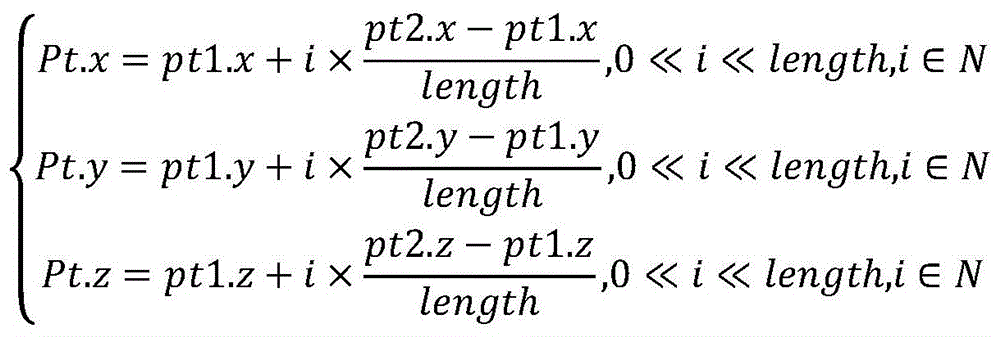
(401)根据环境空间SPACE(Xmin,Ymin,Zmin,Xmax,Ymax,Zmax)和种子间隔step=2×UAVSIZE,逐点计算种子位置,形成种子位置集合POS={(x,y,z)|P(x,y,z)},其中P(x,y,z)定义如下,

(402)将计算出的每个种子位置与建筑模型列表ListBuilding中的每个建筑模型进行空间关系计算,如果种子落在任意一个建筑模型中,则丢弃该种子,否则将该种子加入种子列表ListSeed中,则种子列表ListSeed中的任意一个种子Seed(x,y,z)针对建筑模型列表ListBuilding的任意一个建筑模型Building(Xmin,Ymin,Zmin,Xmax,Ymax,Zmax),满足如下条件:(402) Calculate the spatial relationship between each calculated seed position and each building model in the building model list ListBuilding, if the seed falls in any building model, discard the seed, otherwise add the seed to the seed list ListSeed , then any seed Seed(x,y,z) in the seed list ListSeed is aimed at any building model Building(Xmin, Ymin, Zmin, Xmax, Ymax, Zmax) of the building model list ListBuilding, and satisfies the following conditions:
Seed.x≤Building.Xmin|Seed.x≥Building.Xmax|Seed.x≤Building.Xmin|Seed.x≥Building.Xmax|
Seed.y≤Building.Ymin|Seed.y≥Building.Ymax|Seed.y≤Building.Ymin|Seed.y≥Building.Ymax|
Seed.z≤Building.Zmin|Seed.z≥Building.ZmaxSeed.z≤Building.Zmin|Seed.z≥Building.Zmax
其中,UAVSIZE为无人机立方体包围盒最大边长,Xmin为最小横坐标,Ymin为最小纵坐标,Zmin为最小高度坐标,Xmax为最大横坐标,Ymax为最大纵坐标,Zmax为最大高度坐标。Among them, UAVSIZE is the maximum side length of the UAV cube bounding box, Xmin is the minimum abscissa, Ymin is the minimum ordinate, Zmin is the minimum height coordinate, Xmax is the maximum abscissa, Ymax is the maximum ordinate, and Zmax is the maximum height coordinate.
其中,步骤(6)中判断两点可视的方法为:对两点pt1和pt2的连线密集采样,如果有一个采样点与建筑模型交叉,则判断两点不通视,处理逻辑如下:Among them, the method of judging the visibility of two points in step (6) is: densely sample the connection between the two points pt1 and pt2, if there is a sampling point intersecting with the building model, it is judged that the two points are not visible, and the processing logic is as follows:
计算两点连线长度:Calculate the length of a line connecting two points:

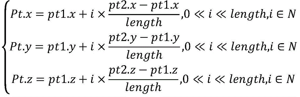
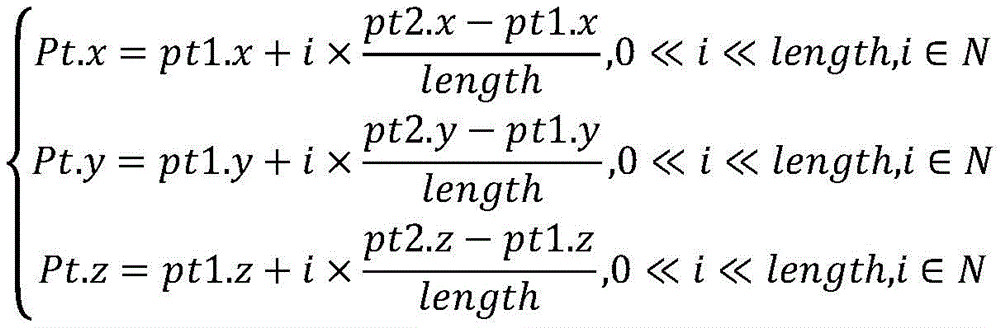
对两点pt1和pt2的连线密集采样,对任意采样点Pt(x,y,z),需满足:For dense sampling of the connection between two points pt1 and pt2, for any sampling point Pt(x, y, z), the following must be satisfied:
针对任一采样点Pt和任一建筑模型Building,如果满足下面条件,则判断该采样点与建筑模型交叉:For any sampling point Pt and any building model Building, if the following conditions are met, it is judged that the sampling point intersects with the building model:
Building.Xmin≤Pt.x≤Building.Xmax&Building.Xmin≤Pt.x≤Building.Xmax&
Building.Ymin≤Pt.y≤Building.Ymax&Building.Ymin≤Pt.y≤Building.Ymax&
Building.Zmin≤Pt.z≤Building.ZmaxBuilding.Zmin≤Pt.z≤Building.Zmax
Building(Xmin,Ymin,Zmin,Xmax,Ymax,Zmax)为任意一个建筑模型的坐标。Building(Xmin, Ymin, Zmin, Xmax, Ymax, Zmax) is the coordinate of any building model.
其中,步骤(7)中计算本航线所有剩余种子与最后一个航路点的距离,取与最后一个航路点通视且距离最近的n个种子,构造出包括原航线在内的n条航线,将相应种子分别加到航线的航路点中,作为最后一个航路点,并将相应的种子从航线的种子列表中移除,具体包括以下步骤:Among them, in step (7), the distance between all remaining seeds of this route and the last waypoint is calculated, and the n seeds that are in sight with the last waypoint and the distance are the closest are constructed to construct n routes including the original route. The corresponding seeds are added to the route's waypoints as the last waypoint, and the corresponding seeds are removed from the route's seed list, which includes the following steps:
(701)在基于原有航线line构造新航线之前,先计算该航线中剩余种子与本航线最后一个航路点的距离;(701) Before constructing a new route based on the original route line, first calculate the distance between the remaining seeds in the route and the last waypoint of this route;
(702)将所有种子与最后一个航路点的距离按从小到大排序,取出距离最后一个航路点最近的n个种子,构造出包括原航线在内的n条航线,将n个种子分别加到n条航线的航路点中,并将相应的种子从航线的种子列表中移除,基于种子seed构造新航线的算法如下:(702) Sort the distances between all the seeds and the last waypoint in ascending order, take out the n seeds closest to the last waypoint, construct n routes including the original route, and add the n seeds to the In the waypoints of n routes, and the corresponding seeds are removed from the seed list of the routes, the algorithm for constructing a new route based on the seed seeds is as follows:
首先基于原有航线line构造新航线:line1=line;First construct a new route based on the original route line: line1=line;
然后将种子seed添加到line1的航路点列表:Then add the seed seed to line1's list of waypoints:
line1.ListPoint.Add(seed);line1.ListPoint.Add(seed);
最后将种子seed从候选种子列表中删除:Finally remove the seed seed from the candidate seed list:
line1.ListSeed.Remove(seed);line1.ListSeed.Remove(seed);
ListPoint为航路点集合,ListSeed为路线规划的候选种子集合。ListPoint is the set of waypoints, and ListSeed is the set of candidate seeds for route planning.
本发明具有如下优点:The present invention has the following advantages:
1、本发明使用均匀分布的空间种子为媒介进行路线规划,航路点位置预知,易于理解;1. The present invention uses uniformly distributed space seeds as a medium for route planning, and the position of waypoints is predicted and easy to understand;
2、本发明采用迭代搜索的方法进行路线规划,代码量小,运行效率高;2. The present invention adopts the iterative search method for route planning, with a small amount of code and high operating efficiency;
3、本发明具有易于扩展、兼容性强的特点;3. The present invention has the characteristics of easy expansion and strong compatibility;
4、本发明还具有易于实现与调试的特点。4. The present invention also has the characteristics of being easy to implement and debug.
附图说明Description of drawings
图1为本发明基于种子搜索的城市建筑空间无人机航线规划示意图。FIG. 1 is a schematic diagram of the UAV route planning in urban building space based on seed search according to the present invention.
图2为本发明方法整体流程。FIG. 2 is the overall flow of the method of the present invention.
图3为本发明播撒种子处理流程。Fig. 3 is the processing flow of the present invention for sowing seeds.
图4为本发明基于种子的航线搜索流程。FIG. 4 is a flow chart of the route search process based on seeds of the present invention.
具体实施方式Detailed ways
下面,结合图1至图4对本发明作进一步说明。Hereinafter, the present invention will be further described with reference to FIG. 1 to FIG. 4 .
本发明综合考虑任务空间范围、建筑分布、无人机通行尺寸等因素,设计了基于均匀分布于空间的种子为媒介的飞行航路规划方法。该方法首先在任务空间建筑间隙中均匀播撒若干种子,然后基于起点创建初始航线,并将种子复制到航线的种子列表中,将航线加入规划中航线列表;遍历规划中航线列表,判断每条航线最后一个航路点是否与终点可视,如可视则本航线完成,如不可视,取本航线种子列表中与最后一个航路点通视且距离较近的n个种子,构造出n条新航线加入规划中航线列表,再逐条判断航线是否完成,如此反复,直到没有新航线产生,最后从一系列完成航线中计算长度最短的航线作为最终规划结果。如图2所示,具体包括以下步骤:The invention comprehensively considers factors such as task space range, building distribution, UAV traffic size, etc., and designs a flight route planning method based on seeds evenly distributed in space. The method firstly sows several seeds evenly in the space between buildings in the task space, then creates an initial route based on the starting point, copies the seeds to the seed list of the route, and adds the route to the list of planned routes; traverses the list of planned routes to determine each route Whether the last waypoint is visible to the end point, if it is visible, the route is completed, if not, take n seeds in the seed list of this route that are in sight and close to the last waypoint, and construct n new routes Add to the list of planned routes, and then judge whether the routes are completed one by one. Repeat this until no new routes are generated. Finally, calculate the route with the shortest length from a series of completed routes as the final planning result. As shown in Figure 2, it specifically includes the following steps:
(1)构造航路规划中所用到的模型,包括任务环境空间模型、建筑模型、种子模型、航线模型,具体定义如下:(1) Models used in the construction of route planning, including task environment space model, building model, seed model, and route model. The specific definitions are as follows:
(101)任务环境空间模型:用于定义任务环境的空间范围,用一个立方体空间表达,定义为SPACE(Xmin,Ymin,Zmin,Xmax,Ymax,Zmax),其中Xmin为环境空间的最小横坐标,Ymin为环境空间的最小纵坐标,Zmin为环境空间的最小高度坐标,Xmax为环境空间的最大横坐标,Ymax为环境空间的最大纵坐标,Zmax为环境空间的最大高度坐标;(101) Task environment space model: used to define the space range of the task environment, expressed in a cube space, defined as SPACE(Xmin, Ymin, Zmin, Xmax, Ymax, Zmax), where Xmin is the minimum abscissa of the environment space, Ymin is the minimum ordinate of the environment space, Zmin is the minimum height coordinate of the environment space, Xmax is the maximum abscissa of the environment space, Ymax is the maximum ordinate of the environment space, and Zmax is the maximum height coordinate of the environment space;
(102)建筑模型:用立方体包围盒表达城市建筑的位置及外观,复杂的建筑模型拆分为多个立方体包围盒的拼接,建筑模型定义为:Building(Xmin,Ymin,Zmin,Xmax,Ymax,Zmax),其中Xmin为建筑模型的最小横坐标,Ymin为建筑模型的最小纵坐标,Zmin为建筑模型的最小高度坐标,Xmax为建筑模型的最大横坐标,Ymax为建筑模型的最大纵坐标,Zmax为建筑模型的最大高度坐标;(102) Architectural model: The location and appearance of urban buildings are expressed with a cube bounding box. The complex building model is split into a splicing of multiple cube bounding boxes. The building model is defined as: Building(Xmin, Ymin, Zmin, Xmax, Ymax, Zmax), where Xmin is the minimum abscissa of the building model, Ymin is the minimum ordinate of the building model, Zmin is the minimum height coordinate of the building model, Xmax is the maximum abscissa of the building model, Ymax is the maximum ordinate of the building model, Zmax is the maximum height coordinate of the building model;
(103)种子模型:均匀分布于环境空间中的三维坐标点,定义为Seed(X,Y,Z),其中X为种子的横坐标,Y为种子的纵坐标,Z为种子的高度坐标;(103) Seed model: three-dimensional coordinate points evenly distributed in the environment space, defined as Seed(X, Y, Z), where X is the abscissa of the seed, Y is the ordinate of the seed, and Z is the height coordinate of the seed;
(104)航线模型:开始于起点、经过若干种子、终止于终点的一条空间折线,航线定义为Line(ListSeed,ListPoint,isOK),其中ListSeed为路线规划的候选种子集合,ListPoint为航路点集合,所有航路点均来源于种子集合,isOK为路线规划完成标志,建立了从起点到终点的航线。(104) Route model: a spatial polyline that starts from the starting point, passes through several seeds, and ends at the end point. The route is defined as Line(ListSeed, ListPoint, isOK), where ListSeed is the set of candidate seeds for route planning, and ListPoint is the set of waypoints. All waypoints are derived from the seed set, and isOK is the completion mark of the route planning, which establishes the route from the start point to the end point.
(2)对象声明:声明航线规划中存储各类对象的变量,主要包括建筑模型列表、种子列表、规划中航线列表、完成航线列表,具体如下:(2) Object declaration: declare the variables that store various objects in the route planning, mainly including the list of building models, the list of seeds, the list of planned routes, and the list of completed routes, as follows:
(201)建筑模型列表:存储所有建筑模型,定义为ListBuilding(Building1,Building2,……);(201) Building model list: store all building models, defined as ListBuilding(Building1, Building2,...);
(202)种子列表:存储所有种子,定义为ListSeed(Seed1,Seed2,……)。(202) Seed list: store all seeds, which are defined as ListSeed(Seed1, Seed2,...).
(203)规划中航线列表:存储所有未最终完成的航线,定义为ListTempLine(Line1,Line2,……,Linen);(203) List of planned routes: store all unfinished routes, defined as ListTempLine(Line1, Line2, ..., Linen);
(204)完成航线列表:存储所有已完成的航线,定义为ListFullLine(Line1,Line2,……,Linen)。(204) List of completed routes: store all completed routes, which are defined as ListFullLine(Line1, Line2, ..., Linen).
(3)获取基本信息:获取任务环境空间范围信息,保存到SPACE对象;获取所有城市建筑模型信息,保存到ListBuilding对象;获取无人机任务起点坐标,保存到START(X,Y,Z)对象;获取无人机任务终点坐标,保存到END(X,Y,Z)对象;获取无人机最大尺寸UAVSIZE。(3) Obtain basic information: obtain the space range information of the task environment and save it to the SPACE object; obtain all urban building model information and save it to the ListBuilding object; obtain the coordinates of the starting point of the drone task and save it to the START(X,Y,Z) object ;Get the coordinates of the end point of the drone mission and save it to the END(X,Y,Z) object; get the maximum size of the drone UAVSIZE.
(4)根据已知环境空间范围、建筑模型坐标数据,向环境中播撒种子,种子均匀填充环境的建筑模型间隙,为了保证无人机飞行安全,种子之间的间隔采用无人机最大尺寸UAVSIZE的2倍,如图3所示,具体步骤如下:(4) According to the known spatial range of the environment and the coordinate data of the building model, seeds are sown into the environment, and the seeds evenly fill the gap of the building model of the environment. In order to ensure the flight safety of the drone, the interval between the seeds is UAVSIZE, the largest size of the drone. 2 times, as shown in Figure 3, the specific steps are as follows:
(401)根据环境空间SPACE(Xmin,Ymin,Zmin,Xmax,Ymax,Zmax)和种子间隔step=2×UAVSIZE,逐点计算种子位置,形成种子位置集合POS={(x,y,z)|P(x,y,z)},(401) According to the environmental space SPACE (Xmin, Ymin, Zmin, Xmax, Ymax, Zmax) and the seed interval step=2×UAVSIZE, calculate the seed position point by point, and form the seed position set POS={(x, y, z)| P(x, y, z)},
其中P(x,y,z)定义如下,

(402)将计算出的每个种子位置与ListBuilding中的每个建筑模型进行空间关系计算,如果种子落在任意一个建筑模型中,则丢弃该种子,否则将该种子加入集合ListSeed中,则集合ListSeed中的任意一个种子Seed(x,y,z)针对集合ListBuilding的任意一个建筑模型Building(Xmin,Ymin,Zmin,Xmax,Ymax,Zmax),必须满足如下条件:(402) Calculate the spatial relationship between each calculated seed position and each building model in ListBuilding, if the seed falls in any building model, discard the seed, otherwise add the seed to the set ListSeed, then the set Any seed Seed(x,y,z) in ListSeed must meet the following conditions for any building model Building(Xmin, Ymin, Zmin, Xmax, Ymax, Zmax) in the set ListBuilding:
Seed.x≤Building.Xmin|Seed.x≥Building.Xmax|Seed.x≤Building.Xmin|Seed.x≥Building.Xmax|
Seed.y≤Building.Ymin|Seed.y≥Building.Ymax|Seed.y≤Building.Ymin|Seed.y≥Building.Ymax|
Seed.z≤Building.Zmin|Seed.z≥Building.ZmaxSeed.z≤Building.Zmin|Seed.z≥Building.Zmax
如图4,基于种子的航线搜索流程如下:As shown in Figure 4, the seed-based route search process is as follows:
(5)基于路线起点创建初始航线,初始航线只包含一个航路点(起点),将所有种子复制到该航路中的种子列表,并将初始航线加入规划中航线列表,具体如下:(5) Create an initial route based on the starting point of the route. The initial route contains only one waypoint (starting point), copy all the seeds to the seed list in the route, and add the initial route to the planned route list, as follows:
line=new Line();line = new Line();
line.ListSeed=ListSeed;line.ListSeed = ListSeed;
line.ListPoint.Add(START);line.ListPoint.Add(START);
ListTempLine.Add(line);ListTempLine.Add(line);
(6)遍历规划中航线列表,判断每条航线最后一个航路点是否与无人机任务终点可视,如果可视,则该航线为完成航线,将无人机任务终点补充到该航线中,并将该航线从规划中航线列表中取出,加入到完成航线列表,规划中航线列表遍历完后转入步骤(8);如果该航线最后一个航路点与无人机任务终点不通视,则转入步骤(7);(6) Traverse the list of routes in the plan, and determine whether the last waypoint of each route is visible to the end point of the UAV mission. If it is visible, the route is a completed route, and the end point of the UAV mission is added to the route. Take the route out of the planned route list, add it to the completed route list, and go to step (8) after traversing the planned route list; Enter step (7);
判断两点通视的方法为:对两点pt1和pt2的连线密集采样,如果有一个采样点与建筑模型交叉,则判断两点不通视,处理逻辑如下:The method for judging two-point visibility is: densely sample the connection between the two points pt1 and pt2. If there is a sampling point intersecting with the building model, it is judged that the two points are not fully visible. The processing logic is as follows:
计算两点连线长度:Calculate the length of a line connecting two points:

对两点pt1和pt2的连线密集采样,对任意采样点Pt(x,y,z),需满足:For dense sampling of the connection between two points pt1 and pt2, for any sampling point Pt(x, y, z), the following must be satisfied:
针对任一采样点Pt和任一建筑模型Building,如果满足下面条件,则判断该采样点与建筑模型交叉:For any sampling point Pt and any building model Building, if the following conditions are met, it is judged that the sampling point intersects with the building model:
Building.Xmin≤Pt.x≤Building.Xmax&Building.Xmin≤Pt.x≤Building.Xmax&
Building.Ymin≤Pt.y≤Building.Ymax&Building.Ymin≤Pt.y≤Building.Ymax&
Building.Zmin≤Pt.z≤Building.ZmaxBuilding.Zmin≤Pt.z≤Building.Zmax
(7)对剩余种子进行判断,若剩余种子数为零或剩余种子均与航线最后一个航路点不通视,则不能构造新航路,航路搜索过程结束,转入步骤(8);否则计算本航线所有剩余种子与最后一个航路点的距离,取与最后一个航路点通视且距离最近的n个种子,构造出包括原航线在内的n条航线,将相应种子分别加到航线的航路点中,作为最后一个航路点,并将相应的种子从航线的种子列表中移除,返回步骤(6);n为设定值;(7) Judging the remaining seeds, if the number of remaining seeds is zero or the remaining seeds are not in sight with the last waypoint of the route, then a new route cannot be constructed, the route search process is over, and go to step (8); otherwise, calculate this route The distance between all the remaining seeds and the last waypoint, take the n seeds that are in sight with the last waypoint and the closest distance, construct n routes including the original route, and add the corresponding seeds to the waypoints of the route respectively , as the last waypoint, and remove the corresponding seed from the seed list of the route, and return to step (6); n is the set value;
计算本航线所有剩余种子与最后航路点的距离,取距离最后航路点距离较近且与最后航路点通视的n个种子,构造出包括原航线在内的n条航线,将n个种子分别加到n条航线的航路点中,并将相应的种子从航线的种子列表中移除,具体步骤如下:Calculate the distance between all the remaining seeds of this route and the last waypoint, take n seeds that are close to the last waypoint and in line with the last waypoint, construct n routes including the original route, and separate the n seeds Add to the waypoints of n routes, and remove the corresponding seeds from the route's seed list. The specific steps are as follows:
(701)在基于原有航线line构造新航线之前,先要计算该航线中剩余种子与本航线最后一个航路点pt的距离,具体计算方法如下:(701) Before constructing a new route based on the original route line, the distance between the remaining seeds in the route and the last waypoint pt of the route should be calculated. The specific calculation method is as follows:

(702)将所有种子与pt的距离按从小到大排序,取出距离pt最近的n个种子,构造出包括原航线在内的n条航线,将n个种子分别加到n条航线的航路点中,并将相应的种子从航线的种子列表中移除,基于种子seed构造新航线的算法如下:(702) Sort the distances between all seeds and pt in ascending order, take out the n seeds closest to pt, construct n routes including the original route, and add the n seeds to the waypoints of the n routes respectively , and remove the corresponding seed from the seed list of the route. The algorithm for constructing a new route based on the seed seed is as follows:
首先基于原有航线line构造新航线:line1=line;First construct a new route based on the original route line: line1=line;
然后将种子seed添加到line1的航路点列表:Then add the seed seed to line1's list of waypoints:
line1.ListPoint.Add(seed);line1.ListPoint.Add(seed);
最后将种子seed从候选种子列表中删除:Finally remove the seed seed from the candidate seed list:
line1.ListSeed.Remove(seed);line1.ListSeed.Remove(seed);
其中,因为种子均匀充满任务空间,最后一个航路点如果不在任务空间边界时,其总会处于一个由最近的26个种子构成的立方体中心,构造新航线时,应兼顾所有方向和程序运行效率,建议n取值最大为26。Among them, because the seeds evenly fill the mission space, if the last waypoint is not at the boundary of the mission space, it will always be in the center of a cube composed of the nearest 26 seeds. When constructing a new route, all directions and program operation efficiency should be taken into account. It is recommended that the maximum value of n be 26.
(8)如果完成航线列表中航线数量为0,则不存在从起点到终点的航线,航路规划结束;如果完成航线列表中航线数量不为0,则逐条计算每条航线的距离,取距离最短的航线作为本次规划的最终航线。(8) If the number of routes in the completed route list is 0, there is no route from the starting point to the end point, and the route planning ends; if the number of routes in the completed route list is not 0, calculate the distance of each route one by one, and take the shortest distance route as the final route of this planning.
Claims (4)


Priority Applications (1)
| Application Number | Priority Date | Filing Date | Title |
|---|---|---|---|
| CN202010200496.2A CN111272179B (en) | 2020-03-20 | 2020-03-20 | A route planning method for construction space UAV based on seed search |
Applications Claiming Priority (1)
| Application Number | Priority Date | Filing Date | Title |
|---|---|---|---|
| CN202010200496.2A CN111272179B (en) | 2020-03-20 | 2020-03-20 | A route planning method for construction space UAV based on seed search |
Publications (2)
| Publication Number | Publication Date |
|---|---|
| CN111272179A true CN111272179A (en) | 2020-06-12 |
| CN111272179B CN111272179B (en) | 2021-08-31 |
Family
ID=70998373
Family Applications (1)
| Application Number | Title | Priority Date | Filing Date |
|---|---|---|---|
| CN202010200496.2A Active CN111272179B (en) | 2020-03-20 | 2020-03-20 | A route planning method for construction space UAV based on seed search |
Country Status (1)
| Country | Link |
|---|---|
| CN (1) | CN111272179B (en) |
Cited By (4)
| Publication number | Priority date | Publication date | Assignee | Title |
|---|---|---|---|---|
| CN112004237A (en) * | 2020-07-14 | 2020-11-27 | 西安爱生无人机技术有限公司 | UAV data link visibility evaluation method, readable storage medium and terminal equipment |
| CN112729312A (en) * | 2020-12-25 | 2021-04-30 | 云南电网有限责任公司昆明供电局 | Unmanned aerial vehicle inspection method for high-voltage chamber of transformer substation |
| CN113239864A (en) * | 2021-05-31 | 2021-08-10 | 南通大学 | Route planning method of unmanned aerial vehicle suitable for agricultural investigation |
| CN113325867A (en) * | 2021-05-21 | 2021-08-31 | 华中科技大学 | Path planning method and device for searching of unmanned aircraft and unmanned aircraft |
Citations (13)
| Publication number | Priority date | Publication date | Assignee | Title |
|---|---|---|---|---|
| CN102393747A (en) * | 2011-08-17 | 2012-03-28 | 清华大学 | Collaborative interaction method of unmanned aerial vehicle swarm and visual navigation system of unmanned aerial vehicle |
| US20160060039A1 (en) * | 2014-08-29 | 2016-03-03 | Ksi Conveyors, Inc. | Seed Distributor for Even Dispersion at Varying Flow Rates |
| US20160070261A1 (en) * | 2014-09-10 | 2016-03-10 | Appareo Systems, Llc | Automated flight control system for unmanned aerial vehicles |
| US20160306351A1 (en) * | 2015-04-14 | 2016-10-20 | Vantage Robotics, Llc | System for authoring, executing, and distributing unmanned aerial vehicle flight-behavior profiles |
| CN107368600A (en) * | 2017-07-26 | 2017-11-21 | 兰州交通大学 | The adjoint point of Random Graph and Edge Coloring algorithm can be distinguished |
| CN107943072A (en) * | 2017-11-13 | 2018-04-20 | 深圳大学 | Unmanned plane during flying path generating method, device, storage medium and equipment |
| CN108764080A (en) * | 2018-05-17 | 2018-11-06 | 中国电子科技集团公司第五十四研究所 | A kind of unmanned plane vision barrier-avoiding method based on cloud space binaryzation |
| US20190021236A1 (en) * | 2017-07-20 | 2019-01-24 | Brett Evan Patrick | Method and apparatus for airborne dissemination and implantation of seeds |
| CN109598341A (en) * | 2018-11-21 | 2019-04-09 | 济南浪潮高新科技投资发展有限公司 | A kind of detection of convolutional neural networks training result and method for visualizing based on genetic algorithm |
| CN109683630A (en) * | 2019-01-25 | 2019-04-26 | 南京邮电大学 | Unmanned aerial vehicle flight path planing method based on population and PRM algorithm |
| CN110077598A (en) * | 2019-04-22 | 2019-08-02 | 四川省农业科学院作物研究所 | A kind of sowing rice type unmanned plane and its control system |
| CN110239719A (en) * | 2019-07-01 | 2019-09-17 | 南京林业大学 | UAV precise seeding system and method |
| CN110320933A (en) * | 2019-07-29 | 2019-10-11 | 南京航空航天大学 | Unmanned plane avoidance motion planning method under a kind of cruise task |
-
2020
- 2020-03-20 CN CN202010200496.2A patent/CN111272179B/en active Active
Patent Citations (13)
| Publication number | Priority date | Publication date | Assignee | Title |
|---|---|---|---|---|
| CN102393747A (en) * | 2011-08-17 | 2012-03-28 | 清华大学 | Collaborative interaction method of unmanned aerial vehicle swarm and visual navigation system of unmanned aerial vehicle |
| US20160060039A1 (en) * | 2014-08-29 | 2016-03-03 | Ksi Conveyors, Inc. | Seed Distributor for Even Dispersion at Varying Flow Rates |
| US20160070261A1 (en) * | 2014-09-10 | 2016-03-10 | Appareo Systems, Llc | Automated flight control system for unmanned aerial vehicles |
| US20160306351A1 (en) * | 2015-04-14 | 2016-10-20 | Vantage Robotics, Llc | System for authoring, executing, and distributing unmanned aerial vehicle flight-behavior profiles |
| US20190021236A1 (en) * | 2017-07-20 | 2019-01-24 | Brett Evan Patrick | Method and apparatus for airborne dissemination and implantation of seeds |
| CN107368600A (en) * | 2017-07-26 | 2017-11-21 | 兰州交通大学 | The adjoint point of Random Graph and Edge Coloring algorithm can be distinguished |
| CN107943072A (en) * | 2017-11-13 | 2018-04-20 | 深圳大学 | Unmanned plane during flying path generating method, device, storage medium and equipment |
| CN108764080A (en) * | 2018-05-17 | 2018-11-06 | 中国电子科技集团公司第五十四研究所 | A kind of unmanned plane vision barrier-avoiding method based on cloud space binaryzation |
| CN109598341A (en) * | 2018-11-21 | 2019-04-09 | 济南浪潮高新科技投资发展有限公司 | A kind of detection of convolutional neural networks training result and method for visualizing based on genetic algorithm |
| CN109683630A (en) * | 2019-01-25 | 2019-04-26 | 南京邮电大学 | Unmanned aerial vehicle flight path planing method based on population and PRM algorithm |
| CN110077598A (en) * | 2019-04-22 | 2019-08-02 | 四川省农业科学院作物研究所 | A kind of sowing rice type unmanned plane and its control system |
| CN110239719A (en) * | 2019-07-01 | 2019-09-17 | 南京林业大学 | UAV precise seeding system and method |
| CN110320933A (en) * | 2019-07-29 | 2019-10-11 | 南京航空航天大学 | Unmanned plane avoidance motion planning method under a kind of cruise task |
Non-Patent Citations (4)
| Title |
|---|
| CHEN, WEI等: ""A Seed-Based Diffusion Route to Monodisperse Intermetallic CuAu Nanocrystal"", 《ANGEWANDTE CHEMIE-INTERNATIONAL EDITION》 * |
| 柴兴华等: ""无人机智能测控技术研究综述"", 《无线电工程》 * |
| 王文旭等: ""无人机覆盖航迹规划中子区域合并方法设计"", 《电子设计工程》 * |
| 王璐: ""固定翼无人机自动着舰飞控系统设计"", 《中国优秀硕士学位论文全文数据库 工程科技Ⅱ辑》 * |
Cited By (5)
| Publication number | Priority date | Publication date | Assignee | Title |
|---|---|---|---|---|
| CN112004237A (en) * | 2020-07-14 | 2020-11-27 | 西安爱生无人机技术有限公司 | UAV data link visibility evaluation method, readable storage medium and terminal equipment |
| CN112004237B (en) * | 2020-07-14 | 2023-06-16 | 西安爱生无人机技术有限公司 | Unmanned aerial vehicle data link vision evaluation method, readable storage medium and terminal equipment |
| CN112729312A (en) * | 2020-12-25 | 2021-04-30 | 云南电网有限责任公司昆明供电局 | Unmanned aerial vehicle inspection method for high-voltage chamber of transformer substation |
| CN113325867A (en) * | 2021-05-21 | 2021-08-31 | 华中科技大学 | Path planning method and device for searching of unmanned aircraft and unmanned aircraft |
| CN113239864A (en) * | 2021-05-31 | 2021-08-10 | 南通大学 | Route planning method of unmanned aerial vehicle suitable for agricultural investigation |
Also Published As
| Publication number | Publication date |
|---|---|
| CN111272179B (en) | 2021-08-31 |
Similar Documents
| Publication | Publication Date | Title |
|---|---|---|
| CN111272179A (en) | Building space unmanned aerial vehicle route planning method based on seed search | |
| Tan et al. | Automatic inspection data collection of building surface based on BIM and UAV | |
| CN110428111B (en) | UAV/UGV (unmanned aerial vehicle/user generated Union vector) cooperative long-time multitask operation trajectory planning method | |
| CN103699135B (en) | The flight path automatic planning in depopulated helicopter pesticide spraying farmland operation region | |
| CN102880186B (en) | flight path planning method based on sparse A* algorithm and genetic algorithm | |
| CN113865589B (en) | Long-distance rapid path planning method based on terrain gradient | |
| CN115185303B (en) | Unmanned aerial vehicle patrol path planning method for national parks and natural protected areas | |
| US20220215621A1 (en) | Three-dimensional model-based coverage path planning method for unmanned aerial vehicles | |
| CN105913469B (en) | TF/TA2 path planning methods based on skeleton drawing | |
| CN106979784A (en) | Non-linear track planning based on hybrid pigeon swarm algorithm | |
| CN118411415B (en) | Mobile robot relocalization method and device based on whale algorithm and ensemble learning | |
| CN118896610B (en) | UAV route planning method and system based on deep reinforcement learning | |
| Huang et al. | A path planning method in three-dimensional complex space based on Bézier curves and a hybrid zebra optimization algorithm | |
| CN117008639A (en) | A real-time path planning method for UAVs based on digital twins | |
| CN119358791B (en) | Unmanned aerial vehicle-based power line inspection method and system | |
| CN120802979A (en) | Reinforced learning unmanned aerial vehicle route planning method and system based on safe flight corridor | |
| Yıldırım et al. | A comparative study of optimization algorithms for global path planning of mobile robots | |
| Zhang et al. | Based on Navmesh to implement AI intelligent pathfinding in three-dimensional maps in UE4 | |
| Yang et al. | Automatic design method of building pipeline layout based on deep reinforcement learning | |
| Mekni | Automated generation of geometrically-precise and semantically-informed virtual geographic environments populated with spatially-reasoning agents | |
| CN120232426A (en) | Wind farm drone inspection path planning method, device, equipment and medium | |
| Chi et al. | AM-RRT*: an automatic robot motion planning algorithm based on RRT | |
| CN119065384A (en) | An optimal path planning method for UAV based on fully expanded graph | |
| Niu et al. | Study on Multiobjective Path Optimization of Plant Protection Robots Based on Improved ACO‐DWA Algorithm | |
| Lu et al. | Research on a route planning method for military transport aircraft based on GWO algorithm |
Legal Events
| Date | Code | Title | Description |
|---|---|---|---|
| PB01 | Publication | ||
| PB01 | Publication | ||
| SE01 | Entry into force of request for substantive examination | ||
| SE01 | Entry into force of request for substantive examination | ||
| GR01 | Patent grant | ||
| GR01 | Patent grant |