CN110889394A - Rice lodging recognition method based on deep learning UNet network - Google Patents
Rice lodging recognition method based on deep learning UNet network Download PDFInfo
- Publication number
- CN110889394A CN110889394A CN201911267940.6A CN201911267940A CN110889394A CN 110889394 A CN110889394 A CN 110889394A CN 201911267940 A CN201911267940 A CN 201911267940A CN 110889394 A CN110889394 A CN 110889394A
- Authority
- CN
- China
- Prior art keywords
- image
- unet network
- network model
- lodging
- unet
- Prior art date
- Legal status (The legal status is an assumption and is not a legal conclusion. Google has not performed a legal analysis and makes no representation as to the accuracy of the status listed.)
- Pending
Links
Images

Classifications
-
- G—PHYSICS
- G06—COMPUTING OR CALCULATING; COUNTING
- G06V—IMAGE OR VIDEO RECOGNITION OR UNDERSTANDING
- G06V20/00—Scenes; Scene-specific elements
- G06V20/10—Terrestrial scenes
- G06V20/188—Vegetation
-
- G—PHYSICS
- G06—COMPUTING OR CALCULATING; COUNTING
- G06F—ELECTRIC DIGITAL DATA PROCESSING
- G06F18/00—Pattern recognition
- G06F18/20—Analysing
- G06F18/21—Design or setup of recognition systems or techniques; Extraction of features in feature space; Blind source separation
- G06F18/214—Generating training patterns; Bootstrap methods, e.g. bagging or boosting
Landscapes
- Engineering & Computer Science (AREA)
- Theoretical Computer Science (AREA)
- Physics & Mathematics (AREA)
- Data Mining & Analysis (AREA)
- General Physics & Mathematics (AREA)
- Bioinformatics & Cheminformatics (AREA)
- Computer Vision & Pattern Recognition (AREA)
- Evolutionary Biology (AREA)
- Evolutionary Computation (AREA)
- Bioinformatics & Computational Biology (AREA)
- General Engineering & Computer Science (AREA)
- Artificial Intelligence (AREA)
- Life Sciences & Earth Sciences (AREA)
- Health & Medical Sciences (AREA)
- General Health & Medical Sciences (AREA)
- Multimedia (AREA)
- Image Analysis (AREA)
Abstract
Description
技术领域technical field
本发明涉及图像识别技术领域,特别涉及一种基于深度学习UNet网络的水稻倒伏识别方法。The invention relates to the technical field of image recognition, in particular to a rice lodging recognition method based on a deep learning UNet network.
背景技术Background technique
水稻是世界三大粮食作物之一,其产量稳定对世界政治、经济都具有重大的影响。倒伏是干扰水稻生产的重要胁迫因素,其通过减弱植株光合作用,引起产量下降,当倒伏连片且面积达到一定程度后会对机械化收割造成困难,增加农户收割成本。此外,如遇阴雨天气,地面积水较多,容易引发水稻霉变,严重影响到稻米品质和食品安全。因此,水稻倒伏面积、程度的及时、有效监测,在水稻种植管理以及后续农业保险政策制定过程中具有重要作用。传统的水稻倒伏采用人工实地测量,需要专业人员现场进行测量取样分析,耗时、耗力且效率极低,准确度也因倒伏面积大小不同统计结果极不准确,而且,在测量过程中可能对作物造成二次伤害。因此,迫切需要有更加高效的方法进行水稻倒伏信息获取。Rice is one of the three major food crops in the world, and the stability of its output has a significant impact on world politics and economy. Lodging is an important stress factor that interferes with rice production. It reduces plant photosynthesis and causes yield decline. When lodging is contiguous and the area reaches a certain level, it will cause difficulties in mechanized harvesting and increase the harvesting cost of farmers. In addition, in case of rainy weather, the land will be covered with more water, which will easily lead to mildew of rice, which will seriously affect the quality of rice and food safety. Therefore, timely and effective monitoring of rice lodging area and degree plays an important role in rice planting management and subsequent agricultural insurance policy formulation. Traditional rice lodging uses manual field measurement, which requires professionals to conduct on-site measurement and sampling analysis, which is time-consuming, labor-intensive, and extremely inefficient. The accuracy is also extremely inaccurate due to the size of the lodging area. Crops deal secondary damage. Therefore, there is an urgent need for a more efficient method to obtain information on rice lodging.
卫星遥感通过航天卫星获取作物卫星影像,具有快速、高效的特点,近年来已愈来愈多被应用到作物倒伏信息提取上,然而受限于遥感卫星固定的运行周期以及自身的分辨率,卫星遥感无法做到实时、高精度地对倒伏信息进行监测分析。此外,卫星影像由于云层、大气的干扰,极大地影响了监测的可靠性。Satellite remote sensing obtains crop satellite images through space satellites, which is fast and efficient. In recent years, it has been more and more applied to the extraction of crop lodging information. Remote sensing cannot monitor and analyze lodging information in real time and with high precision. In addition, satellite imagery greatly affects the reliability of monitoring due to cloud cover and atmospheric interference.
发明内容SUMMARY OF THE INVENTION
本发明的目的在于提供一种基于深度学习UNet网络的水稻倒伏识别方法,可以准确的通过拍照识别水稻倒伏区域。The purpose of the present invention is to provide a rice lodging identification method based on the deep learning UNet network, which can accurately identify the rice lodging area by taking pictures.
为实现以上目的,本发明采用的技术方案为:一种基于深度学习UNet网络的水稻倒伏识别方法,包括如下步骤:S1、拍摄待检测稻田图像并进行分块处理,分块处理后的图像宽度和高度为32的倍数;S2、提取分块后图像的像元值或计算植被指数输入到训练好的UNet网络模型中;S3、将UNet网络模型输出的图像依次进行二值化处理、滤波处理得到分割结果图;S4、计算分割结果图中倒伏区域占总区域的比值即可得到倒伏占比。In order to achieve the above purpose, the technical solution adopted in the present invention is: a method for identifying rice lodging based on a deep learning UNet network, comprising the following steps: S1, photographing an image of a paddy field to be detected and performing block processing, and the width of the image after block processing and the height is a multiple of 32; S2, extract the pixel value of the image after segmentation or calculate the vegetation index and input it into the trained UNet network model; S3, perform binarization processing and filtering processing on the images output by the UNet network model in turn Obtaining the segmentation result graph; S4, calculating the ratio of the lodging area to the total area in the segmentation result graph to obtain the lodging ratio.
与现有技术相比,本发明存在以下技术效果:这里通过对图像进行处理得到田块的倒伏占比,图像可以通过无人机进行拍摄,其机动性强,受云层和雾的影响小,图像的分辨率很高,这样识别起来也更加精准;同时,这里利用了UNet深度学习框架,此模型可以自主地学习到数据中的各种浅层、深层特征,具有泛化性高的优点,非常容易扩展到其他特征的识别上。Compared with the prior art, the present invention has the following technical effects: here, the lodging ratio of the field is obtained by processing the image, the image can be photographed by an unmanned aerial vehicle, its maneuverability is strong, and it is less affected by clouds and fog, The resolution of the image is very high, so the recognition is more accurate; at the same time, the UNet deep learning framework is used here, this model can autonomously learn various shallow and deep features in the data, and has the advantage of high generalization. It is very easy to extend to the recognition of other features.
附图说明Description of drawings
图1是本发明的流程示意图。FIG. 1 is a schematic flow chart of the present invention.
具体实施方式Detailed ways
下面结合图1,对本发明做进一步详细叙述。The present invention will be described in further detail below with reference to FIG. 1 .
参阅图1,一种基于深度学习UNet网络的水稻倒伏识别方法,包括如下步骤:S1、拍摄待检测稻田图像并进行分块处理,分块处理后的图像宽度和高度为32的倍数;S2、提取分块后图像的像元值或计算植被指数输入到训练好的UNet网络模型中;S3、将UNet网络模型输出的图像依次进行二值化处理、滤波处理得到分割结果图;S4、计算分割结果图中倒伏区域占总区域的比值即可得到倒伏占比。这里通过对图像进行处理得到田块的倒伏占比,图像可以通过无人机进行拍摄,其机动性强,受云层和雾的影响小,图像的分辨率很高,这样识别起来也更加精准;同时,这里利用了UNet深度学习框架,此模型可以自主地学习到数据中的各种浅层、深层特征,具有泛化性高的优点,非常容易扩展到其他特征的识别上。Referring to Fig. 1, a method for identifying rice lodging based on deep learning UNet network includes the following steps: S1, photographing an image of a paddy field to be detected and performing block processing, and the image width and height after block processing are multiples of 32; S2, Extract the pixel value of the image after the block or calculate the vegetation index and input it into the trained UNet network model; S3. Perform binarization processing and filtering processing on the image output by the UNet network model in turn to obtain the segmentation result map; S4. Calculate the segmentation result The ratio of the lodging area to the total area in the result graph can be used to obtain the lodging percentage. Here, the lodging ratio of the field is obtained by processing the image. The image can be captured by a drone, which has strong maneuverability, is less affected by clouds and fog, and has a high resolution of the image, which makes the identification more accurate; At the same time, the UNet deep learning framework is used here. This model can autonomously learn various shallow and deep features in the data. It has the advantage of high generalization and is very easy to extend to the recognition of other features.
UNet是一种广泛用于语义分割任务的深度学习网络框架,其最早由OlafRonneberger提出用于医学图像的分割任务,与一般卷积网络不同的是,UNet是一种不包含全连接层的全卷积网络,并且对数据集量的要求不高,简单高效且直观易用。本发明在原始UNet结构的基础上进行创新,使其适合于倒伏水稻冠层图像的分割任务,这里优选地,所述步骤S2中的UNet网络模型按如下步骤训练得到:S21、建立初始的UNet网络模型;S22、生成数据集:拍摄任意稻田图像并对图像进行拼接、裁剪以及数据增广操作得到多张小图,将多张小图随机分为训练集、验证集和测试集;S23、将训练集代入步骤S21中初始的UNet网络模型中进行训练,训练后再将验证集代入训练好的UNet网络模型中调整模型参数并挑出最高精度的模型作为最终模型;S24、将测试集代入最终模型中测试模型识别精度,若识别精度大于等于设定阈值,则将该最终模型作为步骤S2中训练好的UNet网络模型,若识别精度小于设定阈值,则重新选择稻田执行步骤S22-S24直至识别精度大于等于设定阈值。通过设置训练集、验证集和测试集,可以方便的训练出最优的UNet网络模型。UNet is a deep learning network framework widely used for semantic segmentation tasks. It was first proposed by Olaf Ronneberger for the segmentation task of medical images. Unlike general convolutional networks, UNet is a full volume that does not contain fully connected layers. It is simple, efficient, and intuitive to use. The present invention innovates on the basis of the original UNet structure, so that it is suitable for the segmentation task of the lodging rice canopy image. Here, preferably, the UNet network model in the step S2 is trained according to the following steps: S21. Establish an initial UNet Network model; S22. Generate data set: take any image of rice field and perform image splicing, cropping and data augmentation operations to obtain multiple small images, and randomly divide the multiple small images into training set, validation set and test set; S23. Substitute the training set into In step S21, training is performed in the initial UNet network model, and after training, the verification set is substituted into the trained UNet network model to adjust the model parameters and select the model with the highest accuracy as the final model; S24, substitute the test set into the final model for testing Model recognition accuracy. If the recognition accuracy is greater than or equal to the set threshold, the final model is used as the UNet network model trained in step S2. If the recognition accuracy is less than the set threshold, the paddy field is reselected to perform steps S22-S24 until the recognition accuracy is greater than equal to the set threshold. By setting the training set, validation set and test set, the optimal UNet network model can be easily trained.
UNet的网络结构主要分为编码器与解码器两部分,编码器通过多层卷积连续采样以获得图像的不同层次特征,在此基础上,解码器再对顶层特征图谱进行多层反卷积,并结合采样过程中不同层次特征,将特征图谱恢复到原来输入图像的大小,完成对图像端对端的语义分割任务。故本发明中优选地,所述的步骤S21中,UNet网络模型包括编码器和解码器;编码器包括:S211、输入图像首先经过2次Conv+BN+Relu组合生成64通道的特征图谱;S212、64通道的特征图谱经过连续4次的Maxpool+(Conv+BN+Relu)×2组合生成分辨率为原图1/16大小的1024维特征图谱。解码器包括:S213、经过连续4次的UpConv+(Conv+BN+Relu)×2组合操作将1024维特征图谱上采样为原图大小的64维特征图谱,并在途中利用跳跃连接将编码器生成的中间特征图谱拼接到解码器生成的特征图谱上;S214、经过1次Conv将拼接后的64维特征图谱生成分割图像;以上步骤S211-S214中,Conv为卷积层,BN为批标准化层,Relu为激活层,Maxpool为最大池化层,UpConv为转置卷积层。The network structure of UNet is mainly divided into two parts: encoder and decoder. The encoder continuously samples through multi-layer convolution to obtain different levels of features of the image. On this basis, the decoder performs multi-layer deconvolution on the top-level feature map. , and combined with different levels of features in the sampling process, the feature map is restored to the size of the original input image, and the end-to-end semantic segmentation task of the image is completed. Therefore, preferably in the present invention, in the described step S21, the UNet network model includes an encoder and a decoder; the encoder includes: S211, the input image is first combined with Conv+BN+Relu twice to generate a feature map of 64 channels; S212 , The feature map of 64 channels is combined by Maxpool+(Conv+BN+Relu)×2 for 4 consecutive times to generate a 1024-dimensional feature map with a resolution of 1/16 of the original image. The decoder includes: S213. After 4 consecutive UpConv+(Conv+BN+Relu)×2 combined operations, the 1024-dimensional feature map is up-sampled into a 64-dimensional feature map of the original image size, and the encoder is generated by skip connections on the way. splicing the intermediate feature map of the spliced onto the feature map generated by the decoder; S214, after 1 Conv, generate a segmented image from the spliced 64-dimensional feature map; in the above steps S211-S214, Conv is the convolution layer, and BN is the batch normalization layer. , Relu is the activation layer, Maxpool is the maximum pooling layer, and UpConv is the transposed convolutional layer.
UNet网络模型采用dice系数作为评价指标,dice系数是一种在图像分割领域常用的评价指标,其计算公式如下:The UNet network model uses the dice coefficient as an evaluation index. The dice coefficient is a commonly used evaluation index in the field of image segmentation. Its calculation formula is as follows:

其中,Rseg为分割后的结果,Rgt为人工标注的结果,dice系数的含义为两幅图像相交部分占总面积的比值,取值范围在0-1之间,越接近1说明两图像越相似,模型效果越好。Among them, R seg is the result of segmentation, R gt is the result of manual annotation, and the meaning of the dice coefficient is the ratio of the intersection of the two images to the total area. The value ranges from 0 to 1. The closer to 1, the two images The more similar, the better the model.
进一步地,所述的步骤S22中,按如下步骤生成数据集:S221、通过无人机拍摄稻田图像,通过无人机拍摄稻田图像,实现起来非常简单、成本低、使用灵活,拍摄时,可以让无人机搭载高分辨率数码相机拍摄高清的RGB图像,也可以搭载G\R\NIR波段的多光谱相机。本实施例中,以大疆Phantom4作为无人机平台,搭载的数码相机分辨率为4000*3000pixels,视场角为94°,多光谱相机为MAPIR CAMERA公司生产的Servey3相机,包含绿(550nm)、红(660nm)、近红外(850nm)三个波段,简称RGN(Red,Green,NIR),拍摄得到图像分辨率为4000*3000pixels,视场角(FOV)为87°。拍摄时,无人机飞行高度为距水稻冠层100m,由DJI GS Pro软件进行自动航线规划飞行,覆盖地面面积为7.97公顷。Further, in the step S22, the data set is generated according to the following steps: S221, the image of the paddy field is photographed by the drone, and the image of the paddy field is photographed by the drone, which is very simple to implement, low in cost, and flexible in use. Let the drone be equipped with a high-resolution digital camera to shoot high-definition RGB images, and it can also be equipped with a multi-spectral camera in the G\R\NIR band. In this example, the DJI Phantom4 is used as the UAV platform, the digital camera is equipped with a resolution of 4000*3000pixels, a field of view of 94°, and the multispectral camera is the Servey3 camera produced by MAPIR CAMERA, including green (550nm) , red (660nm), near-infrared (850nm) three bands, referred to as RGN (Red, Green, NIR), the resolution of the captured image is 4000*3000pixels, and the field of view (FOV) is 87°. When shooting, the drone flew at a height of 100m from the rice canopy, and the DJI GS Pro software performed automatic route planning and flight, covering a ground area of 7.97 hectares.
S222、对拍摄到的图像进行拼接,并将拼接后图像中感兴趣的区域裁剪出来得到一张原始大图,本实施例中,无人机拍摄得到的图像有普通RGB图像以及多光谱图像,其中RGB图像由航迹规划软件触发拍摄得到,可直接由Agisoft LLC公司研发的AgisoftPhotoscan软件进行图像拼接,使用Adobe公司研发的PhotoShop CC软件完成图像裁剪;多光谱图像为12bit RAW格式,且为2s定时拍摄得到,包含大部分无用图像,因此首先需要使用Survey3相机配套的软件进行格式转换,然后对转换后的图像进行筛选,随之利用AgisoftPhotoscan软件进行图像拼接,对拼接后的图像进行校准后,即可利用PhotoShopCC软件对感兴趣区域进行图像裁剪操作,得到的RGB图像分辨率为7337*7660pixels,多光谱图像分辨率为6754*7370pixels。S222, stitching the captured images, and cropping out the region of interest in the stitched images to obtain an original large image. In this embodiment, the images captured by the drone include ordinary RGB images and multispectral images. The RGB images are captured by the track planning software, which can be directly stitched by the Agisoft Photoscan software developed by Agisoft LLC, and cropped by the PhotoShop CC software developed by Adobe; the multispectral images are in 12bit RAW format with 2s timing The captured image contains most of the useless images. Therefore, it is first necessary to use the software provided with the Survey3 camera to perform format conversion, and then screen the converted images, and then use Agisoft Photoscan software to perform image stitching. After the stitched images are calibrated, that is, PhotoShopCC software can be used to crop the region of interest, and the obtained RGB image resolution is 7337*7660pixels, and the multispectral image resolution is 6754*7370pixels.
S223、对原始大图进行进行人工标记得到标记大图,这里可以借助LabelMe软件来辅助标记;S223、将原始大图进行随机切割、随机翻转、随机旋转、随机放缩、随机错切、随机形变操作生成多张原始小图,对原始大图进行操作的时候同步对标记大图操作得到对应的标记小图,标记时可以使用LabelMe软件由人工目视解译得到,所有的标记小图即为Groundtruth数据集。S224、按照(0.6~0.8):(0.2~0.1):(0.2~0.1)的比例将原始小图随机分为训练集、验证集和测试集。经过数据预处理后得到整个研究区的单张RGB图像以及单张多光谱图像,由于后续模型训练的需要,这里对图像进行数据增广操作,本实施例中,将单张的图像随机切割为分辨率为320*320pixels的小图,并对其进行随机翻转、随机旋转、随机放缩、随机错切、随机形变等操作以加强数据集的泛化性。数据增广对两幅大图依次生成了5000张小图,又以0.7:0.15:0.15的比例随机切分为训练集、验证集、测试集。因此最后得到了RGB图像以及多光谱图像训练集各3500张、验证集各750张、测试集各750张。S223. Manually mark the original large image to obtain the marked large image, where LabelMe software can be used to assist in marking; S223, randomly cut, flip, rotate, zoom, and deform the original large image randomly. The operation generates multiple original small pictures. When operating the original large picture, the corresponding marked small pictures can be obtained by synchronizing the marked large picture. When marking, it can be obtained by manual visual interpretation using LabelMe software. All marked small pictures are Groundtruth dataset. S224 , according to the ratio of (0.6~0.8):(0.2~0.1):(0.2~0.1), the original small graph is randomly divided into a training set, a verification set and a test set. After data preprocessing, a single RGB image and a single multispectral image of the entire research area are obtained. Due to the needs of subsequent model training, the data augmentation operation is performed on the image. In this embodiment, the single image is randomly cut into A small image with a resolution of 320*320pixels is randomly flipped, rotated, scaled, staggered, and deformed randomly to enhance the generalization of the dataset. Data augmentation generates 5,000 small images for the two large images in turn, and randomly divides them into training set, validation set, and test set in a ratio of 0.7:0.15:0.15. Therefore, we finally obtained 3500 RGB images and multispectral images for training set, 750 for validation set, and 750 for testing set.
在具体的训练过程中,可以根据需要和经验设置模型参数,本实施例中优选地,所述的步骤S23中,UNet网络模型总循环轮数epochs取值为100,批大小mini-batch size取值为12,初始学习率取值为5e-4且训练过程中每10个epochs学习率减半。In the specific training process, model parameters can be set according to needs and experience. In this embodiment, preferably, in the step S23, the total number of epochs of the UNet network model is 100, and the batch size mini-batch size is 100. The value is 12, the initial learning rate is 5e -4 and the learning rate is halved every 10 epochs during training.
合适的权值初始化对深度神经网络至关重要,Glorot等人的研究表明,不合适的权值初始化将会导致网络梯度爆炸或梯度弥散,最终使得网络无法继续训练。为解决这个问题,一般采用随机初始化方法,将权值在[-1,1]之间赋予随机值,但此方法一定程度上增加了网络的不可控性,而且在某些情况下表现并非较好,基于此,Glorot等人提出了Xavier初始化方法,该方法的目标是使网络各层输出的方差尽可能一致,这样在梯度传播的时候不会造成梯度爆炸或梯度弥散的情况。因此,本发明中优选地,UNet网络模型采用Xavier初始化方法进行初始化。Proper weight initialization is crucial for deep neural networks. The study by Glorot et al. shows that inappropriate weight initialization will lead to network gradient explosion or gradient dispersion, which will eventually make the network unable to continue training. In order to solve this problem, the random initialization method is generally used, and the weights are assigned random values between [-1, 1], but this method increases the uncontrollability of the network to a certain extent, and in some cases the performance is not better. Well, based on this, Glorot et al. proposed the Xavier initialization method. The goal of this method is to make the variance of the output of each layer of the network as consistent as possible, so that gradient propagation will not cause gradient explosion or gradient dispersion. Therefore, in the present invention, preferably, the UNet network model is initialized by using the Xavier initialization method.
进一步地,每个epochs结束时均代入验证集计算当前UNet网络模型的识别精度,将识别精度最高的UNet网络模型作为最终模型。训练初期,loss变化曲线和dice系数变化曲线均表现出较大的震荡现象,在多光谱图像数据集的训练上表现得更加明显,这跟本发明设置的mini-batch size较小有一定关系,使得网络在训练前期不能很好的找到收敛方向,但是随着网络的不断训练,网络逐渐变得稳定。此外,由于加入了每10个epochs便使学习率减半的策略,训练后期网络震荡的规模显得更加小。在RGB图像数据集上,验证精度在第75个epoch达到最高,为0.9382;在多光谱图像数据集上,验证精度在第95个epoch达到最高,为0.9222,这样,我们就可以方便的挑选出最优的UNet网络模型来作为最终模型。Further, at the end of each epochs, it is substituted into the verification set to calculate the recognition accuracy of the current UNet network model, and the UNet network model with the highest recognition accuracy is used as the final model. In the early stage of training, both the loss change curve and the dice coefficient change curve show a large oscillation phenomenon, which is more obvious in the training of the multispectral image data set, which is related to the small mini-batch size set by the present invention. This makes the network unable to find the convergence direction very well in the early stage of training, but with the continuous training of the network, the network gradually becomes stable. In addition, the size of network oscillations in the later stages of training is smaller due to the addition of a policy of halving the learning rate every 10 epochs. On the RGB image dataset, the validation accuracy reaches the highest at the 75th epoch, which is 0.9382; on the multispectral image dataset, the validation accuracy reaches the highest at the 95th epoch, which is 0.9222. In this way, we can easily select The optimal UNet network model is used as the final model.
本实施例中,选取在验证集中达到最高精度的模型作为最终模型,将其应用到测试集,该模型在测试集上表现出的平均性能如下表所示:In this embodiment, the model that achieves the highest accuracy in the validation set is selected as the final model and applied to the test set. The average performance of the model on the test set is shown in the following table:
直观来看,应用两种数据集训练得到的模型基本能将图像上水稻倒伏区域分割出来,上表中的dice系数均在0.92以上也印证了这一点。但从两种数据集之间的差别来看,多光谱图像数据集训练得到的模型的过分割情况高于RGB图像数据集训练得到的模型,上表中的loss值很好地给予说明,即多光谱数据集0.1188多于RGB数据集的0.0961。Intuitively, the models trained with the two datasets can basically segment the rice lodging area on the image, which is also confirmed by the dice coefficients above 0.92 in the table above. However, judging from the difference between the two datasets, the over-segmentation of the model trained on the multispectral image dataset is higher than that of the model trained on the RGB image dataset. The loss value in the above table is well explained, namely 0.1188 for the multispectral dataset is more than 0.0961 for the RGB dataset.
本发明中,在进行UNet网络训练和识别时,UNet网络模型的输入可以有很多种,具体地,所述的步骤S1和步骤S22中,拍摄的图像为RGB图像或多光谱图像;步骤S2、步骤S23以及步骤S24中,UNet网络模型的输入为:RGB图像红、绿、蓝三通道像元值R、G、B构成的深度为3的矩阵;或者为多光谱图像绿、红、近红外三个波段像元值G、R、NIR构成的深度为3的矩阵;或者为RGB图像计算的植被指数构成的深度为3或6的矩阵;或者为多光谱图像计算的植被指数构成的深度为3或6的矩阵。In the present invention, when performing UNet network training and identification, the input of the UNet network model can have many kinds. Specifically, in the steps S1 and S22, the captured images are RGB images or multi-spectral images; Step S2, In step S23 and step S24, the input of the UNet network model is: a matrix with a depth of 3 formed by three channel pixel values R, G, and B of an RGB image; or a multispectral image green, red, and near-infrared. A matrix of depth 3 composed of pixel values G, R, and NIR of three bands; or a matrix of depth 3 or 6 composed of vegetation indices calculated for RGB images; or a depth of vegetation indices calculated for multispectral images 3 or 6 matrix.
当选用RGB图像红、绿、蓝三通道像元值R、G、B作为UNet网络模型输入时,在步骤S1和S221中使用高分辨率数码相机拍摄,步骤S221-S224处理的都是RGB图像。When the pixel values R, G and B of the red, green and blue channels of the RGB image are selected as the input of the UNet network model, a high-resolution digital camera is used to shoot in steps S1 and S221, and steps S221-S224 are all RGB images. .
当选用多光谱图像绿、红、近红外三个波段像元值G、R、NIR作为UNet网络模型输入时,在步骤S1和S221中使用多光谱相机进行拍摄,步骤S221-S224处理的都是多光谱图像。When the pixel values G, R, and NIR of the multi-spectral image in three bands of green, red and near-infrared are selected as the input of the UNet network model, the multi-spectral camera is used for shooting in steps S1 and S221, and the processing in steps S221-S224 are all Multispectral image.
当选用RGB图像计算的植被指数构成的深度为3或6的矩阵作为UNet网络模型输入时,在步骤S1和S221中使用高分辨率数码相机拍摄,步骤S221-S224处理的都是RGB图像,并且在步骤S224后还需要根据三通道像元值R、G、B计算植被指数。When a matrix with a depth of 3 or 6 formed by the vegetation index calculated from the RGB image is selected as the input to the UNet network model, a high-resolution digital camera is used to shoot in steps S1 and S221, and steps S221-S224 are all RGB images processed, and After step S224, the vegetation index needs to be calculated according to the three-channel pixel values R, G, and B.
当选用多光谱图像计算的植被指数构成的深度为3或6的矩阵作为UNet网络模型输入时,在步骤S1和S221中使用多光谱相机进行拍摄,步骤S221-S224处理的都是多光谱图像,并且在步骤S224后还需要根据三个波段像元值G、R、NIR计算植被指数。When a matrix with a depth of 3 or 6 formed by the vegetation index calculated from the multi-spectral image is selected as the input to the UNet network model, the multi-spectral camera is used for shooting in steps S1 and S221, and the multi-spectral images are processed in steps S221-S224. And after step S224, the vegetation index needs to be calculated according to the pixel values G, R, and NIR of the three bands.
植被指数的选择有很多,本发明中优选地,所述的RGB图像计算的植被指数包括超绿植被指数ExG、超红植被指数ExR、可见光波段差异植被指数VDVI、红绿比值指数RGRI、归一化绿红差异指数NGRDI以及超绿超红差分指数ExGR中的任意3种或全6种构成深度为3或6的矩阵;所述的多光谱图像计算的植被指数包括归一化植被指数NDVI、比值植被指数RVI、归一化水指数NDWI、差值植被指数DVI、正交植被指数PVI以及土壤调节植被指数SAVI中的任意3种或全6种构成深度为3或6的矩阵。以上所有植被指数的计算公式如下:There are many choices of vegetation index. Preferably, in the present invention, the vegetation index calculated by the RGB image includes ultra-green vegetation index ExG, ultra-red vegetation index ExR, visible light band difference vegetation index VDVI, red-green ratio index RGRI, normalized Any 3 or all 6 of the green-red difference index NGRDI and the ultra-green and ultra-red difference index ExGR form a matrix with a depth of 3 or 6; the vegetation index calculated by the multispectral image includes the normalized vegetation index NDVI, Any three or all six of the ratio vegetation index RVI, the normalized water index NDWI, the difference vegetation index DVI, the orthogonal vegetation index PVI, and the soil-adjusted vegetation index SAVI constitute a matrix with a depth of 3 or 6. The calculation formulas of all the above vegetation indices are as follows:

以上公式中,R、G、B、NIR分别为图像红绿蓝以及近红外通道的像元值,r、g、b分别为图像红绿蓝通道归一化的像元值,SR和SNIR分别红波段和近红外波段的土壤反射率,VR和VNIR分别是红波段和近红外波段的植被反射率,L是土壤调节系数,取值范围为0~1,L=0时,表示植被覆盖度为0,L=1时,表示土壤背景的影响为0,即植被覆盖度非常高,土壤背景的影响为0,这种情况只有在被树冠浓密的高大树木覆盖的地方才会出现。In the above formula, R, G, B, and NIR are the pixel values of the red, green, and blue channels of the image, respectively, and r, g, and b are the normalized pixel values of the red, green, and blue channels of the image, respectively. S R and S NIR is the soil reflectance in the red band and near-infrared band, respectively, VR and V NIR are the vegetation reflectance in the red band and near-infrared band, respectively, L is the soil adjustment coefficient, the value range is 0~1, when L=0, Indicates that the vegetation coverage is 0. When L=1, it indicates that the influence of the soil background is 0, that is, the vegetation coverage is very high, and the influence of the soil background is 0. This situation occurs only in places covered by tall trees with dense canopies. Appear.
当然还有可以选择其他的植被指数,从RGB图像和多光谱图像中二选一以后,选择合适的植被指数组合,可以得到很多种不同的组合方式,在实验阶段,可以测试多种可能性,然后挑选出识别精度最大的一种组合即可。本发明中,挑选了前三种植被指数构成深度为3的矩阵,还挑选了所有六种植被指数构成深度为6的矩阵,分别进行训练得到模型的平均性能如下表所示:Of course, there are other vegetation indices that can be selected. After selecting one of the RGB images and multispectral images, and selecting the appropriate combination of vegetation indices, many different combinations can be obtained. In the experimental stage, various possibilities can be tested. Then select a combination with the highest recognition accuracy. In the present invention, the first three vegetation indices are selected to form a matrix with a depth of 3, and all six vegetation indices are also selected to form a matrix with a depth of 6, and the average performance of the model obtained by training is shown in the following table:

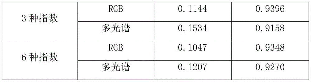
通过与最初的表格比较后我们发现,本实施例中采用RGB图像的红、绿、蓝三通道像元值R、G、B作为UNet网络模型输入时dice系数最高,对应的识别率最高,因此可以优选采用这种方案。实际应用时,可能有其他的组合效果更佳,本发明主要提供一种思路,告诉用户如何通过选择Net网络模型输入来找到最佳的识别模型。After comparing with the original table, we found that in this embodiment, when the pixel values R, G, and B of the red, green, and blue channels of the RGB image are used as the input of the UNet network model, the dice coefficient is the highest, and the corresponding recognition rate is the highest. Therefore, This solution can be preferably adopted. In practical application, there may be other combinations with better effects. The present invention mainly provides an idea to tell the user how to find the best recognition model by selecting the Net network model input.
由于无人机拍摄得到的水稻冠层图像分辨率远大于320*320pixels,且宽和高并非32的倍数,因此不能直接将其输入UNet模型中,故本发明中优选地,所述的步骤S1中,按如下步骤对图像进行分块处理:S11、利用滑窗法遍历图像,每个窗口大小为1280*1280pixels;S12、当滑窗区域超出图像区域时,对滑窗超出部分进行补零操作;S13、遍历完成后将超出区域的结果舍弃。此外,由于UNet模型输出为概率描述,即输出图像的像素值在[0,1]之间,因此需要对其进行阈值处理将其转换为二值图像,故这里优选地,所述的步骤S3中,二值化处理的阈值为0.5,像素值大于等于0.5的为倒伏区域,像素值小于0.5的为非倒伏区域。我们按照以上步骤对原始大图进行分割,并将分割结果与专家人工目视解译的分割图像进行对比分析,计算出完整的RGB图像分割结果的dice系数为0.9626,完整的多光谱图像分割结果的dice系数为0.9531。从分割结果来看,两种数据集的dice系数均达到了0.95以上,效果优异,而且图像左侧由于树木阴影造成的光照不均部分也能较好地分割出来,说明模型能够很好地应对光照不均的问题。Since the resolution of the rice canopy image captured by the drone is much larger than 320*320pixels, and the width and height are not multiples of 32, it cannot be directly input into the UNet model, so preferably in the present invention, the step S1 , perform block processing on the image according to the following steps: S11, use the sliding window method to traverse the image, and the size of each window is 1280*1280pixels; S12, when the sliding window area exceeds the image area, zero-fill the excess part of the sliding window. ; S13. After the traversal is completed, the result beyond the area is discarded. In addition, since the output of the UNet model is a probabilistic description, that is, the pixel value of the output image is between [0, 1], it needs to be thresholded to convert it into a binary image, so here preferably, the step S3 Among them, the threshold value of the binarization process is 0.5, the pixel value greater than or equal to 0.5 is the lodging area, and the pixel value less than 0.5 is the non-lodging area. We segment the original large image according to the above steps, and compare and analyze the segmentation result with the segmented image interpreted by experts manually. The dice coefficient of the complete RGB image segmentation result is calculated to be 0.9626, and the complete multispectral image segmentation result is The dice coefficient is 0.9531. From the segmentation results, the dice coefficients of the two datasets are both above 0.95, which is excellent, and the uneven illumination on the left side of the image due to tree shadows can also be segmented well, indicating that the model can cope well The problem of uneven lighting.
这里主要计算的是所拍摄稻田区域的整体倒伏占比,后续可以对分割结果图进行人工区域标记,区分开不同的田块以计算每一块田的倒伏区域占田块总区域的比例,基于此比例可进行农业灾损评估,以期为农业保险赔付提供技术支持。The main calculation here is the overall lodging ratio of the photographed paddy field area. Later, you can manually mark the segmentation result map to distinguish different fields to calculate the ratio of the lodging area of each field to the total field area. Based on this The ratio can be used for agricultural disaster damage assessment, in order to provide technical support for agricultural insurance compensation.
Claims (8)

Priority Applications (1)
| Application Number | Priority Date | Filing Date | Title |
|---|---|---|---|
| CN201911267940.6A CN110889394A (en) | 2019-12-11 | 2019-12-11 | Rice lodging recognition method based on deep learning UNet network |
Applications Claiming Priority (1)
| Application Number | Priority Date | Filing Date | Title |
|---|---|---|---|
| CN201911267940.6A CN110889394A (en) | 2019-12-11 | 2019-12-11 | Rice lodging recognition method based on deep learning UNet network |
Publications (1)
| Publication Number | Publication Date |
|---|---|
| CN110889394A true CN110889394A (en) | 2020-03-17 |
Family
ID=69751524
Family Applications (1)
| Application Number | Title | Priority Date | Filing Date |
|---|---|---|---|
| CN201911267940.6A Pending CN110889394A (en) | 2019-12-11 | 2019-12-11 | Rice lodging recognition method based on deep learning UNet network |
Country Status (1)
| Country | Link |
|---|---|
| CN (1) | CN110889394A (en) |
Cited By (14)
| Publication number | Priority date | Publication date | Assignee | Title |
|---|---|---|---|---|
| CN111461052A (en) * | 2020-04-13 | 2020-07-28 | 安徽大学 | Identification method of wheat lodging areas in multiple growth stages based on transfer learning |
| CN111461053A (en) * | 2020-04-13 | 2020-07-28 | 安徽大学 | Identification system of wheat lodging areas in multiple growth stages based on transfer learning |
| CN112020982A (en) * | 2020-09-15 | 2020-12-04 | 中联农业机械股份有限公司 | Automatic lodging crop harvesting method and harvester |
| CN112163639A (en) * | 2020-10-20 | 2021-01-01 | 华南农业大学 | Crop lodging classification method based on height distribution characteristic vector |
| CN112597855A (en) * | 2020-12-15 | 2021-04-02 | 中国农业大学 | Crop lodging degree identification method and device |
| CN114170260A (en) * | 2021-12-06 | 2022-03-11 | 华南农业大学 | Real-time image blade segmentation system and method based on vegetation index |
| CN114235148A (en) * | 2022-02-25 | 2022-03-25 | 南京信息工程大学 | Road night illumination quality monitoring method based on noctilucent remote sensing data |
| CN114267005A (en) * | 2020-09-15 | 2022-04-01 | 中联农业机械股份有限公司 | Harvesting method, device, processor and agricultural machine for crops |
| CN114299379A (en) * | 2021-11-01 | 2022-04-08 | 中国矿业大学(北京) | A method for extracting vegetation coverage in shadow areas based on high dynamic images |
| CN114581768A (en) * | 2022-01-19 | 2022-06-03 | 北京市农林科学院信息技术研究中心 | Method and device for monitoring crop lodging by unmanned aerial vehicle |
| CN114677671A (en) * | 2022-02-18 | 2022-06-28 | 深圳大学 | An automatic identification method of mustard tendons based on multispectral images and deep learning |
| WO2023029373A1 (en) * | 2021-08-30 | 2023-03-09 | 广东海洋大学 | High-precision farmland vegetation information extraction method |
| CN116030342A (en) * | 2022-12-09 | 2023-04-28 | 四川天艺生态园林集团股份有限公司 | Method, device, equipment and storage medium for detecting water shortage state of greening plants |
| CN120406559A (en) * | 2025-03-21 | 2025-08-01 | 中国科学院自动化研究所 | UAV dispatching method, device, equipment and medium based on farmland lodging identification |
Citations (7)
| Publication number | Priority date | Publication date | Assignee | Title |
|---|---|---|---|---|
| CN108537182A (en) * | 2018-04-13 | 2018-09-14 | 中国中医科学院中药研究所 | Chinese medicine cultivated area method for automatically counting based on unmanned aerial vehicle remote sensing data |
| CN108710863A (en) * | 2018-05-24 | 2018-10-26 | 东北大学 | Unmanned plane Scene Semantics dividing method based on deep learning and system |
| CN109308695A (en) * | 2018-09-13 | 2019-02-05 | 镇江纳兰随思信息科技有限公司 | Based on the cancer cell identification method for improving U-net convolutional neural networks model |
| CN109508746A (en) * | 2018-11-16 | 2019-03-22 | 西安电子科技大学 | Pulsar candidate's body recognition methods based on convolutional neural networks |
| CN109544579A (en) * | 2018-11-01 | 2019-03-29 | 上海理工大学 | A method of damage building is assessed after carrying out calamity using unmanned plane |
| US20190108384A1 (en) * | 2017-10-05 | 2019-04-11 | TuSimple | System and method for aerial video traffic analysis |
| CN110009637A (en) * | 2019-04-09 | 2019-07-12 | 北京化工大学 | A Remote Sensing Image Segmentation Network Based on Tree Structure |
-
2019
- 2019-12-11 CN CN201911267940.6A patent/CN110889394A/en active Pending
Patent Citations (7)
| Publication number | Priority date | Publication date | Assignee | Title |
|---|---|---|---|---|
| US20190108384A1 (en) * | 2017-10-05 | 2019-04-11 | TuSimple | System and method for aerial video traffic analysis |
| CN108537182A (en) * | 2018-04-13 | 2018-09-14 | 中国中医科学院中药研究所 | Chinese medicine cultivated area method for automatically counting based on unmanned aerial vehicle remote sensing data |
| CN108710863A (en) * | 2018-05-24 | 2018-10-26 | 东北大学 | Unmanned plane Scene Semantics dividing method based on deep learning and system |
| CN109308695A (en) * | 2018-09-13 | 2019-02-05 | 镇江纳兰随思信息科技有限公司 | Based on the cancer cell identification method for improving U-net convolutional neural networks model |
| CN109544579A (en) * | 2018-11-01 | 2019-03-29 | 上海理工大学 | A method of damage building is assessed after carrying out calamity using unmanned plane |
| CN109508746A (en) * | 2018-11-16 | 2019-03-22 | 西安电子科技大学 | Pulsar candidate's body recognition methods based on convolutional neural networks |
| CN110009637A (en) * | 2019-04-09 | 2019-07-12 | 北京化工大学 | A Remote Sensing Image Segmentation Network Based on Tree Structure |
Non-Patent Citations (2)
| Title |
|---|
| XIN ZHAO ET AL: "Use of Unmanned Aerial Vehicle Imagery and Deep Learning UNet to Extract Rice Lodging", 《SENSORS》, vol. 19, no. 18, 6 September 2019 (2019-09-06), pages 2 * |
| 郑二功等: "基于深度学习的无人机影像玉米倒伏区域提取", 《河南农业科学》, vol. 47, no. 8, 15 August 2018 (2018-08-15), pages 155 - 160 * |
Cited By (19)
| Publication number | Priority date | Publication date | Assignee | Title |
|---|---|---|---|---|
| CN111461053A (en) * | 2020-04-13 | 2020-07-28 | 安徽大学 | Identification system of wheat lodging areas in multiple growth stages based on transfer learning |
| CN111461052A (en) * | 2020-04-13 | 2020-07-28 | 安徽大学 | Identification method of wheat lodging areas in multiple growth stages based on transfer learning |
| CN111461052B (en) * | 2020-04-13 | 2023-05-23 | 安徽大学 | Wheat lodging area identification method for multiple growth periods based on transfer learning |
| CN111461053B (en) * | 2020-04-13 | 2023-05-23 | 安徽大学 | Multi-growth-period wheat lodging area identification system based on transfer learning |
| CN112020982A (en) * | 2020-09-15 | 2020-12-04 | 中联农业机械股份有限公司 | Automatic lodging crop harvesting method and harvester |
| CN114267005A (en) * | 2020-09-15 | 2022-04-01 | 中联农业机械股份有限公司 | Harvesting method, device, processor and agricultural machine for crops |
| CN112163639A (en) * | 2020-10-20 | 2021-01-01 | 华南农业大学 | Crop lodging classification method based on height distribution characteristic vector |
| CN112163639B (en) * | 2020-10-20 | 2023-09-26 | 华南农业大学 | A crop lodging classification method based on height distribution feature vector |
| CN112597855A (en) * | 2020-12-15 | 2021-04-02 | 中国农业大学 | Crop lodging degree identification method and device |
| CN112597855B (en) * | 2020-12-15 | 2024-04-16 | 中国农业大学 | Method and device for identifying the degree of crop lodging |
| WO2023029373A1 (en) * | 2021-08-30 | 2023-03-09 | 广东海洋大学 | High-precision farmland vegetation information extraction method |
| CN114299379A (en) * | 2021-11-01 | 2022-04-08 | 中国矿业大学(北京) | A method for extracting vegetation coverage in shadow areas based on high dynamic images |
| CN114170260A (en) * | 2021-12-06 | 2022-03-11 | 华南农业大学 | Real-time image blade segmentation system and method based on vegetation index |
| CN114170260B (en) * | 2021-12-06 | 2024-05-31 | 华南农业大学 | A real-time image leaf segmentation system and method based on vegetation index |
| CN114581768A (en) * | 2022-01-19 | 2022-06-03 | 北京市农林科学院信息技术研究中心 | Method and device for monitoring crop lodging by unmanned aerial vehicle |
| CN114677671A (en) * | 2022-02-18 | 2022-06-28 | 深圳大学 | An automatic identification method of mustard tendons based on multispectral images and deep learning |
| CN114235148A (en) * | 2022-02-25 | 2022-03-25 | 南京信息工程大学 | Road night illumination quality monitoring method based on noctilucent remote sensing data |
| CN116030342A (en) * | 2022-12-09 | 2023-04-28 | 四川天艺生态园林集团股份有限公司 | Method, device, equipment and storage medium for detecting water shortage state of greening plants |
| CN120406559A (en) * | 2025-03-21 | 2025-08-01 | 中国科学院自动化研究所 | UAV dispatching method, device, equipment and medium based on farmland lodging identification |
Similar Documents
| Publication | Publication Date | Title |
|---|---|---|
| CN110889394A (en) | Rice lodging recognition method based on deep learning UNet network | |
| CN111461052B (en) | Wheat lodging area identification method for multiple growth periods based on transfer learning | |
| CN111461053B (en) | Multi-growth-period wheat lodging area identification system based on transfer learning | |
| Liu et al. | Estimating leaf area index using unmanned aerial vehicle data: shallow vs. deep machine learning algorithms | |
| Farmonov et al. | Crop type classification by DESIS hyperspectral imagery and machine learning algorithms | |
| EP4154159B1 (en) | System and method for estimating vegetation coverage in a real-world environment | |
| US11710232B2 (en) | Image processing based advisory system and a method thereof | |
| Olenskyj et al. | End-to-end deep learning for directly estimating grape yield from ground-based imagery | |
| TWI760782B (en) | System and method for orchard recognition on geographic area | |
| Ilniyaz et al. | Leaf area index estimation of pergola-trained vineyards in arid regions using classical and deep learning methods based on UAV-based RGB images | |
| Concepcion et al. | Estimation of photosynthetic growth signature at the canopy scale using new genetic algorithm-modified visible band triangular greenness index | |
| CN112147078A (en) | Multi-source remote sensing monitoring method for crop phenotype information | |
| CN111462223A (en) | Identification method of soybean and corn planting area in Jianghuai region based on Sentinel-2 image | |
| CN114782843B (en) | A Crop Yield Prediction Method and System Based on UAV Multispectral Image Fusion | |
| CN110765977A (en) | Method for extracting wheat lodging information based on multi-temporal remote sensing data of unmanned aerial vehicle | |
| CN112597855B (en) | Method and device for identifying the degree of crop lodging | |
| CN117496345A (en) | A multi-terrain and multi-band cultivated land extraction method based on CVCUnet | |
| CN115690781A (en) | A method and system for identifying fruit tree diseases based on multispectral images | |
| CN114581768A (en) | Method and device for monitoring crop lodging by unmanned aerial vehicle | |
| CN114663785A (en) | Litchi disease detection method and system based on hyperspectrum of unmanned aerial vehicle | |
| CN118691989A (en) | A method for detecting aquatic plant coverage based on airborne hyperspectral | |
| CN113239715A (en) | Rape harvest feeding amount detection method and device based on image processing | |
| CN115035423B (en) | Hybrid rice parent and parent identification extraction method based on unmanned aerial vehicle remote sensing image | |
| CN114821300A (en) | Method for judging plant protection operation time for preventing wheat scab based on multispectral remote sensing of unmanned aerial vehicle | |
| CN115588015B (en) | Lodging area segmentation method based on Improved_Unet network |
Legal Events
| Date | Code | Title | Description |
|---|---|---|---|
| PB01 | Publication | ||
| PB01 | Publication | ||
| SE01 | Entry into force of request for substantive examination | ||
| SE01 | Entry into force of request for substantive examination | ||
| WD01 | Invention patent application deemed withdrawn after publication | ||
| WD01 | Invention patent application deemed withdrawn after publication |
Application publication date: 20200317 |