CN110865402B - Precise single point positioning method, positioning device and recording medium - Google Patents
Precise single point positioning method, positioning device and recording medium Download PDFInfo
- Publication number
- CN110865402B CN110865402B CN201811601450.0A CN201811601450A CN110865402B CN 110865402 B CN110865402 B CN 110865402B CN 201811601450 A CN201811601450 A CN 201811601450A CN 110865402 B CN110865402 B CN 110865402B
- Authority
- CN
- China
- Prior art keywords
- satellite
- satellite signal
- signal
- data
- point positioning
- Prior art date
- Legal status (The legal status is an assumption and is not a legal conclusion. Google has not performed a legal analysis and makes no representation as to the accuracy of the status listed.)
- Active
Links
Images


Classifications
-
- G—PHYSICS
- G01—MEASURING; TESTING
- G01S—RADIO DIRECTION-FINDING; RADIO NAVIGATION; DETERMINING DISTANCE OR VELOCITY BY USE OF RADIO WAVES; LOCATING OR PRESENCE-DETECTING BY USE OF THE REFLECTION OR RERADIATION OF RADIO WAVES; ANALOGOUS ARRANGEMENTS USING OTHER WAVES
- G01S19/00—Satellite radio beacon positioning systems; Determining position, velocity or attitude using signals transmitted by such systems
- G01S19/38—Determining a navigation solution using signals transmitted by a satellite radio beacon positioning system
- G01S19/39—Determining a navigation solution using signals transmitted by a satellite radio beacon positioning system the satellite radio beacon positioning system transmitting time-stamped messages, e.g. GPS [Global Positioning System], GLONASS [Global Orbiting Navigation Satellite System] or GALILEO
- G01S19/42—Determining position
- G01S19/43—Determining position using carrier phase measurements, e.g. kinematic positioning; using long or short baseline interferometry
Landscapes
- Engineering & Computer Science (AREA)
- Radar, Positioning & Navigation (AREA)
- Remote Sensing (AREA)
- Computer Networks & Wireless Communication (AREA)
- Physics & Mathematics (AREA)
- General Physics & Mathematics (AREA)
- Position Fixing By Use Of Radio Waves (AREA)
Abstract
精密单点定位方法及其定位装置。精密单点定位方法包括获得目标卫星的第一卫星信号以及参考卫星的第二卫星信号。结合该第一卫星信号以及该第二卫星信号,以消除一信号误差并得到一结合卫星信号。对该结合卫星信号的电码数据执行一平滑处理,以得到进行定位所需要的卫星定位数据,该卫星定位数据包括修正后电码数据与修正后载波相位数据。

Precise single point positioning method and positioning device. The precise point positioning method includes obtaining a first satellite signal of a target satellite and a second satellite signal of a reference satellite. The first satellite signal and the second satellite signal are combined to eliminate a signal error and obtain a combined satellite signal. A smoothing process is performed on the code data combined with the satellite signal to obtain satellite positioning data required for positioning, and the satellite positioning data includes corrected code data and corrected carrier phase data.
Description
技术领域technical field
本发明是有关于卫星定位技术,且特别是有关于精密单点定位方法及其定位装置以及记录媒体。The present invention relates to satellite positioning technology, and more particularly, to a precise point positioning method, a positioning device and a recording medium.
背景技术Background technique
随着电子信息的发展,地图的信息也电子化。配合其他科技包括卫星定位系统(satellite positioning system,SPS)的技术,将定位组件定位于电子地图上已经是很普遍的现象。在实际应用上,当使用者所携带可移动的使用者设备(user equipment,UE),例如移动电话或是导航设备,其一般会具有定位功能,可以让用户在地图上所处的位置。定位的方式有多种,其中卫星定位是一种方法。With the development of electronic information, the information of the map is also electronic. In conjunction with other technologies including satellite positioning system (SPS) technology, positioning components on an electronic map has become a common phenomenon. In practical applications, when a user carries a movable user equipment (UE), such as a mobile phone or a navigation device, it generally has a positioning function, which can show the user's location on a map. There are many ways of positioning, of which satellite positioning is one method.
发明内容SUMMARY OF THE INVENTION
本发明提供精密单点定位技术,至少可以加速其初始收敛时间。The present invention provides precise single-point positioning technology, which can at least accelerate its initial convergence time.
于一实施例,本发明提供一种精密单点定位方法,由一使用者设备执行,包括获得目标卫星的第一卫星信号以及参考卫星的第二卫星信号。结合该第一卫星信号以及该第二卫星信号,以消除一信号误差并得到一结合卫星信号。对该结合卫星信号的电码数据执行一平滑处理,以得到进行定位所需要的卫星定位数据,该卫星定位数据包括修正后电码数据与修正后载波相位数据。In one embodiment, the present invention provides a precise point positioning method, executed by a user equipment, including obtaining a first satellite signal of a target satellite and a second satellite signal of a reference satellite. The first satellite signal and the second satellite signal are combined to eliminate a signal error and obtain a combined satellite signal. A smoothing process is performed on the code data combined with the satellite signal to obtain satellite positioning data required for positioning, and the satellite positioning data includes corrected code data and corrected carrier phase data.
于一实施例,本发明也提供一种精密单点定位装置,包括处理器以及缓存器,共同配置成处理以下操作,包括获得目标卫星的第一卫星信号以及参考卫星的第二卫星信号。结合该第一卫星信号以及该第二卫星信号,以消除一信号误差并得到一结合卫星信号。对该结合卫星信号的电码数据执行一平滑处理,以得到进行定位所需要的卫星定位数据,该卫星定位数据包括修正后电码数据与修正后载波相位数据。In one embodiment, the present invention also provides a precise point positioning device including a processor and a buffer, which are jointly configured to process the following operations, including obtaining a first satellite signal of a target satellite and a second satellite signal of a reference satellite. The first satellite signal and the second satellite signal are combined to eliminate a signal error and obtain a combined satellite signal. A smoothing process is performed on the code data combined with the satellite signal to obtain satellite positioning data required for positioning, and the satellite positioning data includes corrected code data and corrected carrier phase data.
于一实施例,本发明也提供一种精密单点定位方法,由一使用者设备执行,包括每隔一时间间隔由目标卫星接收一次误差修正处理后的卫星定位信号,其中当前是第n次接收,n为正整数,其中该卫星定位信号包含第n次的电码数据与载波相位数据。对当前第n次该电码数据执行一平滑处理以得到平滑后的该第n次该电码数据。该平滑处理在当前时间点n进行递归包括:取当前第n次该电码数据为第一项,取第n-1次平滑后的该电码数据加上当前第n次的该载波相位数据及前第n-1次的该载波相位数据的总和为第二项,对该第一项与该第二项之间分别以参数a’及(1-a’)权重加总,而得到当前第n次递归平滑后的该电码数据。该参数a’包含卫星相对该用者设备的卫星仰角,该参数a’随该卫星仰角增加而减小。In one embodiment, the present invention also provides a precise point positioning method, which is executed by a user equipment, and includes receiving an error-corrected satellite positioning signal from the target satellite every time interval, wherein the current is the nth time. Receiving, n is a positive integer, wherein the satellite positioning signal includes the nth code data and carrier phase data. A smoothing process is performed on the current n-th telegram data to obtain the n-th telegram data after smoothing. The smoothing process recursively at the current time point n includes: taking the current nth telegram data as the first item, taking the n-1th smoothed telegram data plus the current nth carrier phase data and the previous The sum of the carrier phase data of the n-1th time is the second item, and the weights of parameters a' and (1-a') are added between the first item and the second item, respectively, to obtain the current nth item. The code data after recursive smoothing. The parameter a' contains the satellite elevation angle of the satellite relative to the user equipment, and the parameter a' decreases as the satellite elevation angle increases.
于一实施例,本发明也提供一种记录媒体,记录程序代码,该程序代码由使用者设备的处理器取得以执行如前述的精密单点定位方法。In an embodiment, the present invention also provides a recording medium for recording program codes, the program codes are obtained by the processor of the user equipment to execute the above-mentioned precise point positioning method.
为让本发明的上述特征和优点能更明显易懂,下文特举实施例,并配合所附图式作详细说明如下。In order to make the above-mentioned features and advantages of the present invention more obvious and easy to understand, the following embodiments are given and described in detail with the accompanying drawings as follows.
附图说明Description of drawings
图1是依照本发明的实施例,卫星定位系统的定位机制示意图。FIG. 1 is a schematic diagram of a positioning mechanism of a satellite positioning system according to an embodiment of the present invention.
图2是依照本发明的实施例,在使用者设备的精密单点定位装置架构示意图。FIG. 2 is a schematic diagram of the structure of a precise single point positioning device in a user equipment according to an embodiment of the present invention.
图3是依照本发明的实施例,精密单点定位方法示意图。FIG. 3 is a schematic diagram of a precise single point positioning method according to an embodiment of the present invention.
图4是依照本发明的实施例,精密单点定位方法中仰角平滑机制示意图。4 is a schematic diagram of an elevation angle smoothing mechanism in a precise single-point positioning method according to an embodiment of the present invention.
附图标记列表List of reference signs
50:卫星群组50: Satellite Group
50a、50b、50c:卫星50a, 50b, 50c: Satellites
52:使用者设备52: User Equipment
54:参考站54: Reference Station
56:网络控制中心56: Network Control Center
58:地面上连系统58: Ground connection system
60:网络60: Network
105:天线105: Antenna
110:接收器110: Receiver
120:处理器120: Processor
130:缓存器130: Buffer
140:存储器装置140: Memory device
142:误差修正模块142: Error correction module
144:差分处理模块144: Differential processing module
146:可适应性载波平滑处理模块146: Adaptive carrier smoothing processing module
148:精密单点定位(PPP)处理模块148: Precision single point positioning (PPP) processing module
150:输入输出装置150: Input and output device
200:精密单点定位装置200: Precision single point positioning device
S100、S102、S104、S106、S108、S110:步骤S100, S102, S104, S106, S108, S110: Steps
具体实施方式Detailed ways
本发明是关于在卫星定位系统中所使用的精密单点定位技术。本发明提供的精密单点定位技术至少可以缩短收敛时间。The present invention relates to precise single point positioning technology used in satellite positioning systems. The precise single-point positioning technology provided by the present invention can at least shorten the convergence time.
以下举多个实施例来说明本发明,但是本发明不限于所举的多个实施例。Hereinafter, the present invention will be described with reference to a plurality of embodiments, but the present invention is not limited to the described embodiments.
当使用者设备在地面需要定位时,接收从卫星发出的无线电信号。此无线电信号提供该卫星的坐标信息。一般由四个不同位置的卫星的信号可以得到用户设备的位置。卫星定位系统例如包括全球定位系统(Global Positioning System,GPS),全球导航卫星系统(Global Navigation Satellite System,GNSS),其更例如中国系统的北斗卫星导航系统(Beidou Navigation Satellite System,BDS)、欧洲系统的伽利略(Galileo)及俄国系统的全球导航卫星系统(Globalnaya navigatsionnaya sputnikovaya sistema,GLONASS)等等。When the user equipment needs to be positioned on the ground, it receives radio signals from satellites. This radio signal provides coordinate information for the satellite. Generally, the position of the user equipment can be obtained from the signals of four satellites in different positions. Satellite positioning systems include, for example, the Global Positioning System (GPS), the Global Navigation Satellite System (GNSS), more such as the Beidou Navigation Satellite System (BDS) of the Chinese system, the European system Galileo (Galileo) and the Russian system of global navigation satellite system (Globalnaya navigatsionnaya sputnikovaya sistema, GLONASS) and so on.
在卫星定位系统的定位机制中,精密单点定位(Precise point positioning,PPP)是近几年来被广泛运用及研究的技术,其特色为不受实时动态定位(Real TimeKinematic,RTK)技术中移动站与参考站之间基线距离的限制,并且能够提供使用者数十公分至数公分不等的定位精度。In the positioning mechanism of satellite positioning system, Precise Point Positioning (PPP) is a technology that has been widely used and studied in recent years. The limit of the baseline distance between reference stations, and can provide users with positioning accuracy ranging from tens of centimeters to several centimeters.
精密单点定位的效能与其收敛时间是相关。精密单点定位初始收敛时间过长,例如20~40分钟或是更长,其是一个需要考虑的问题。The performance of precise point positioning is related to its convergence time. The initial convergence time of precise single point positioning is too long, for example, 20 to 40 minutes or longer, which is a problem that needs to be considered.
图1是依照本发明的实施例,卫星定位系统的定位机制示意图。参阅图1,对于卫星定位系统,其包含卫星群组50,是由多个卫星50a,50b,50c所组成,在本实施例中,以三个卫星为例。这些卫星可以是相同型或是不相同型的卫星,例如是GLONASS(Global NavigationSatellite System)系统的卫星、GPS(Global Positioning System)系统的卫星等等。FIG. 1 is a schematic diagram of a positioning mechanism of a satellite positioning system according to an embodiment of the present invention. Referring to FIG. 1, the satellite positioning system includes a
具有卫星定位系统的接收机的用户设备52例如是设置在车辆上,其位置可能会随需要而移动。卫星定位系统的接收端还可包含设置在固定位置的参考站54。参考站54的数量不限于一个,其依照需要可以有多个。The
卫星群组50的每一个卫星50a,50b,50c可分别发送关于卫星当下位置的信息给参考站54及使用者设备52。用户设备52直接接收的信号是原始的第一信号。在固定位置设置的参考站54也同时接收到卫星发送的信号。这些参考站54接收的信号会先做处理以得到一般性的误差修正数据,以此误差修正数据做为第二信号,在一实施例中,此误差修正数据为初级误差修正数据。参考站54将此第二信号通过网络控制中心56及网络60传送至用户设备52,以使使用者设备52取得此第二信号。用户设备52将第一信号根据第二信号的修正后得到对应此工作频率的卫星信号。不同频率的卫星信号,可以由具有多频功能的相同卫星或是不同卫星提供,一般是由相同卫星提供。Each
另外依照实际需要,使用者设备52也可以不经由网络60取得第二信号,例如网络控制中心56将第二信号传送给地面上连(uplink)系统58再传送给卫星50c,而再由卫星50c传送给用户设备52。In addition, according to actual needs, the
卫星信号的接收涉及多种误差,例如包括卫星时表误差、接收机时表误差、卫星轨道偏移误差、电离层误差、对流层误差、噪声等等。参考站54所产生的第二信号可提供卫星的一般性的误差修正,其例如是卫星轨道偏移误差及卫星时表误差。The reception of satellite signals involves a variety of errors, including, for example, satellite timing errors, receiver timing errors, satellite orbit offset errors, ionospheric errors, tropospheric errors, noise, and the like. The second signal generated by the
对于一般的多频的卫星,卫星定位系统中的卫星使用至少一个载波频率信号。用户设备在定位操作时会接收卫星的一个载波频率信号。若要消除电离层的效应,可再取得另一个载波频率信号,结合多个载波频率信号后,可以消除电离层的误差效应。此另一个载波频率信号可以由多频的相同卫星或是由不同卫星取得。For a typical multi-frequency satellite, the satellites in the satellite positioning system use at least one carrier frequency signal. The user equipment receives a carrier frequency signal from the satellite during the positioning operation. To eliminate the effect of the ionosphere, another carrier frequency signal can be obtained. After combining multiple carrier frequency signals, the error effect of the ionosphere can be eliminated. The other carrier frequency signal can be acquired by the same satellite on multiple frequencies or by different satellites.
在一实施例中,精密单点定位装置是设置或放置在使用者设备52中。在一实施例中,使用者设备52可移动,例如是车辆、火车、船舶、飞机或无人机,其可能会快速移动,或是有时进入隧道,再从隧道快速驶出,重新接收卫星信号。图2是依照本发明的实施例,在使用者设备的精密单点定位装置架构示意图。图3是依照本发明的实施例,精密单点定位方法示意图。In one embodiment, the precise point positioning device is provided or placed in the
上述用户设备52,在多个实施例之一,可以包括图2所显示的精密单点定位装置200的架构或是其组成。请参照图2,精密单点定位装置200至少包括接收器110、处理器120、缓存器130、存储器装置140、以及输入输出装置150。在另一实施例中,精密单点定位装置200可包括天线105。精密单点定位装置200可以对所接收的信号基于卫星间一次差分技术(between satellite single difference,BSSD)消除各种误差来源,例如接收机时表误差、接收机硬件延迟及初始相位误差。除此之外,精密单点定位装置200更可导入适应性载波平滑技术,降低一次差分后电码观测量的噪声层级,经过处理的信号再进行精密单点定位(Precise Point Positioning,PPP)运算。底下将针对整个架构进行说明。The above-mentioned
精密单点定位装置200例如是智能型手机、或是交通工具,例如车辆、火车、船舶、飞机或无人机等,所使用的导航装置(Navigation Device)。The precise
接收器110用以与不同的通信系统以无线的方式进行通信互联,并且收收从卫星发出的无线电信号。此无线电信号提供对应卫星的相关位置讯息。在一实施例中,可由多个,例如三个,不同位置的卫星的信号得到用户设备的位置和/或速度。所述的通信系统例如卫星定位系统例如包括全球定位系统(Global Positioning System,GPS)、全球导航卫星系统(Global Navigation Satellite System,GNSS)、欧洲系统的伽利略(Galileo)、中国系统的北斗卫星导航系统(Beidou Navigation Satellite System,BDS)、或俄国系统的全球导航卫星系统(Globalnaya navigatsionnaya sputnikovaya sistema,GLONASS)等。The
处理器120可以是例如一中央处理单元(central processing unit,CPU)、微控制器(microcontroller)、特殊应用集成电路(application specific integrated circuit,ASIC)等等,或具有特定设计程序化的可编程逻辑设备(programmable logic device,PLD)或现场可编程逻辑门阵列(field programmable gate array,FPGA)等。The
缓存器130用以暂存处理器120运算过程所需暂存的信息,例如可以是高速缓存(Cache Memory)等等。The
存储器装置140用以储存可由处理器120执行处理的各种不同功能模块,在本实施例中包括例如误差修正模块142、执行卫星间一次差分(between satellite singledifference,BSSD)的差分处理模块144、可适应性载波平滑处理模块146、以及精密单点定位(Precise Point Positioning,PPP)处理模块148。而此存储器装置140可以是易失性存储器(Volatile memory),例如随机存取存储器(Random Access Memory,RAM)、只读存储器(Read-Only Memory,ROM)。存储器装置140也可以是非易失性存储器(Non-volatilememory),例如硬盘、闪存(flash memory)或是固态储存装置(solid state storage)等等。The
输入输出(Input/Output)装置150用以输出或是输入数据。精密单点定位装置200的处理器120对所接收的信号基于卫星间一次差分技术(BSSD)消除各种误差来源,并且可导入适应性载波平滑技术,降低一次差分后电码观测量的噪声层级,经过处理的信号再进行精密单点定位(PPP)运算之后,经过输入输出(Input/Output)装置150输出,在一实施例中,可于一导航系统中,在屏幕(未绘示)上的地图中显示目前所在位置。The Input/
请参阅图3,图3是依照本发明的实施例的精密单点定位方法示意图。在一实施例中,可以根据图2的精密单点定位装置200的架构,执行图3的精密单点定位方法。Please refer to FIG. 3 , which is a schematic diagram of a precise single-point positioning method according to an embodiment of the present invention. In one embodiment, the precise single-point positioning method of FIG. 3 can be performed according to the structure of the precise single-
于一实施例,精密单点定位的运作,可能是会包含使用处理程序代码来进行。此所需要的程序代码是记录在记录媒体上。记录媒体可以是内部包含内部设置的存储器装置140,也可以是可以由使用者设备的精密单点定位装置200读取的外部记录媒体。在一实施例中,误差修正模块142、差分处理模块144、可适应性载波平滑处理模块146、以及精密单点定位处理模块148可以是硬件、固件或是储存在存储器装置140而由处理器120所加载执行的软件或机器可执行程序代码。In one embodiment, the operation of precise point positioning may involve the use of handler code. The program code required for this is recorded on a recording medium. The recording medium may be the
步骤S100中,接收器110接收电码数据与载波相位数据的接收。步骤S102中,误差修正模块142进行电离层误差的修正。在一实施例中,开始运作后,每隔一个预定的时间间隔会取得与处理一次数据,以时间点n来代表第n次取得数据。在一实施例中,运作是循环持续进行。对应时间的累积,第n次是指n个时间间隔后的时间点,n为正整数。初始以n=1为开始为例,n=1代表第一次接收卫星信号,其会持续接收分属于每一个卫星的原始(raw)卫星信号。于一实施例,在后续的信号平滑处理是递归的方式,会参考前一个时间点的数据,因此n=1时取得的卫星定位数据尚未经过平滑处理,其可供给n=2的时间点的平滑处理在递归运算时使用。In step S100, the
在步骤S100中,接收器110接收原始第一频率信号,将原始第一频率信号进行初级误差修正数据的修正后成为第一频率的卫星信号,第一频率的卫星信号包含观测(measurement)到的电码观测数据及载波相位(carrier-phase)观测数据,电码观测数据简称为电码数据,以P1(n)或P1表示,载波相位观测数据简称为载波相位数据,以Φ1(n)或Φ1表示,其中以下标1表示第一频率的卫星信号。在一实施例中,接收器110接收原始第二频率信号,将原始第二频率信号进行初级误差修正数据的修正后成为第二频率的卫星信号,可使用第二频率的卫星信号消除电离层误差,第二频率的卫星信号包含电码数据P2(n)及载波相位数据Φ2(n),以下标2表示第二频率的卫星信号。在一实施例中,第二频率的卫星信号可由与发出第一频率的卫星信号的相同卫星的不同频率信道发出。于另一实施例中,第二频率的卫星信号可由与发出第一频率的卫星信号的不同卫星发出。在一实施例中,第一频率的卫星信号(P1,Φ1)与第二频率的卫星信号(P2,Φ2)为已修正卫星轨道偏移误差及卫星时表误差后的信号。In step S100, the
于步骤S102,误差修正模块142根据第一频率的卫星信号(P1,Φ1)与第二频率的卫星信号(P2,Φ2)的结合进行消除电离层误差的处理,而得到无电离层(ionosphere-free)的卫星信号,以下标3来区分包括电码数据P3及载波相位数据Φ3,如式(1):In step S102, the


P3:对应无电离层电码数据的指针P3: Pointer corresponding to ionospheric-free code data
Φ3:对应无电离层载波相位数据的指针Φ3: The pointer corresponding to the phase data of the carrier without ionosphere
ρ:接收机到卫星的几何距离ρ: the geometric distance from the receiver to the satellite
c:光速c: speed of light
r:相对接收机的指标r: Relative receiver index
dtr:接收机时表误差dt r : receiver clock error
T:对流层延迟T: Tropospheric delay
ε:未建模(unmodeled)误差,例如一些温度噪声、多通路(multipath)效应等等ε: Unmodeled errors, such as some temperature noise, multipath effects, etc.
N’:无电离层组合的载波未定值N’: Undetermined value of carrier without ionosphere combination
λ:波长λ: wavelength
在一实施例中,将第一频率的卫星信号(P1,Φ1)与第二频率的卫星信号(P2,Φ2)线性结合,以消除电离层误差并得到电码数据P3及载波相位数据Φ3。In one embodiment, the satellite signal (P 1 , Φ 1 ) of the first frequency and the satellite signal (P 2 , Φ 2 ) of the second frequency are linearly combined to eliminate the ionospheric error and obtain the code data P 3 and the carrier wave Phase data Φ 3 .
在一实施例中,精密单点定位技术的收敛时间可能较长,其原因在于双频无电离层线性组合虽然消除了电离层误差,但可能同时放大了噪声能量。In one embodiment, the convergence time of the precise point positioning technique may be longer because the dual-frequency ionospheric-free linear combination eliminates the ionospheric error, but may also amplify the noise energy.
步骤S102后执行步骤S104,由差分处理模块144进行卫星间一次差分的机制,以消除与接收机相关的误差。在一实施例中,接收机例如是图2的精密单点定位装置200。于一实施例,与接收机相关的误差包含接收机时表误差、接收机硬件延迟以及初始相位误差。于一实施例中,一次差分的处理可能会些微放大了观测量的噪声层级。本发明一实施例中,利用可适应性载波平滑处理模块146执行步骤S106,进行平滑处理,可以有效缩短收敛时间,提升定位效率。Step S104 is executed after step S102, and the
于一实施例,可适应性载波平滑处理模块146中所要平滑的电码数据与载波相位数据会先进行卫星间一次差分的机制。也就是步骤S104的进行卫星间一次差分的机制会先进行,之后才进行步骤S106的平滑处理。In one embodiment, the code data and the carrier phase data to be smoothed in the adaptive carrier smoothing
以下先描述卫星间一次差分的机制。对多个卫星,可以任取其中一个当作参考卫星,此实施例中以指针k表示参考卫星,例如以图1的卫星50a为例。在多个卫星中,除了参考卫星以外的有效卫星中的任一个,例如预计要并入卫星定位的卫星称为目标卫星,在一实施例中,至少需要三个目标卫星的数据以进行定位。此实施例中以指针l表示目标卫星,l为可变,依照实际涉及定位的卫星的数量而定。目标卫星例如是卫星50b、50c等的其一。The mechanism of the first-order difference between satellites is first described below. For a plurality of satellites, any one of them can be taken as a reference satellite. In this embodiment, the pointer k is used to represent the reference satellite, for example, the
也就是说,卫星间一次差分是以多个卫星的其一者当作参考卫星提供参考卫星信号,除了该参考卫星以外的该多个卫星的其一或多个是提供目标卫星信号的目标卫星,其中该参考卫星信号与该目标卫星信号结合,以消除共同性的误差。That is to say, the first-order difference between satellites is that one of a plurality of satellites is used as a reference satellite to provide a reference satellite signal, and one or more of the plurality of satellites other than the reference satellite is a target satellite that provides a target satellite signal , wherein the reference satellite signal is combined with the target satellite signal to eliminate common errors.
在一实施例中,消除电离层误差后的目标卫星信号为第一卫星信号(Pl 3,Φl 3),消除电离层误差后的参考卫星信号为第二卫星信号(Pk 3,Φk 3)。经过卫星间一次差分处理后,得到结合卫星信号,结合卫星信号包括BSSD电码数据Pkl 3及BSSD载波相位数据Φkl 3,如式(2)所示:In one embodiment, the target satellite signal after eliminating the ionospheric error is the first satellite signal (P l 3 , Φ l 3 ), and the reference satellite signal after eliminating the ionospheric error is the second satellite signal (P k 3 , Φ l 3 ). k 3 ). After a differential processing between satellites, the combined satellite signal is obtained, and the combined satellite signal includes the BSSD code data P kl 3 and the BSSD carrier phase data Φ kl 3 , as shown in formula (2):
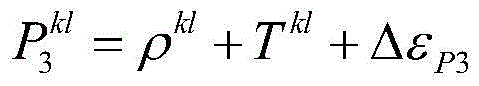

ρkl:接收机到卫星k与卫星l的几何距离的相减ρ kl : the subtraction of the geometric distance from the receiver to the satellite k and the satellite l
Tkl:接收机到卫星k与卫星l的对流层延迟的相减T kl : the subtraction of the tropospheric delay from the receiver to satellite k and satellite l
N’:接收机到卫星k与卫星l的无电离层组合的载波未定值的相减N': receiver-to-carrier-undetermined subtraction of the ionospheric-free combination of satellite k and satellite l
λ:波长λ: wavelength
ΔεP3:接收机到卫星k与卫星l的电码数据未建模误差的相减Δε P3 : Subtraction of unmodeled errors from receiver to satellite k and satellite l's code data
ΔεΦ3:接收机到卫星k与卫星l的载波相位数据未建模误差的相减Δε Φ3 : the subtraction of the unmodeled error of the carrier phase data from the receiver to satellite k and satellite l
在一实施例中,在电码数据的最后一项ΔεP3的误差经过卫星间一次差分的处理后可能会些微放大,可再进行平滑处理,如步骤S106进行平滑处理,其中平滑处理所使用的BSSD电码数据与BSSD载波相位数据是已完成卫星间一次差分处理的数据。In one embodiment, the error of the last item Δε P3 of the code data may be slightly amplified after the first difference processing between satellites, and then smoothing processing can be performed, such as step S106 to perform smoothing processing, wherein the BSSD used for smoothing processing is The code data and the BSSD carrier phase data are the data that have completed the first differential processing between satellites.
以下描述可适应性载波平滑处理模块146的平滑处理机制,其是递归的机制,可利用缓存器130以及处理器120进行暂存处理。如图3所示,缓存器130记录第n-1次的BSSD载波相位数据及平滑过的BSSD电码数据,步骤S110,并在可适应性载波平滑处理模块146完成第n次的平滑处理后,步骤S106,将第n次的BSSD载波相位数据及平滑后的BSSD电码数据更新在缓存器130中(步骤S110),并将第n次的BSSD载波相位数据及平滑后的BSSD电码数据输出到精密单点定位处理模块148,进行后续精密单点定位的处理,步骤S108,以获得精密单点定位装置200的所在位置,并可为精密单点定位装置200定位。在图2中,可适应性载波平滑处理模块146会将进行卫星间一次差分处理以及平滑处理后的平滑电码数据与载波相位数据输出给精密单点定位处理模块148,如步骤S108,进行后续第n次的精密单点定位的定位处理。在一实施例中,精密单点定位处理模块148以多个目标卫星的数据来进行定位,其中各个目标卫星的参考卫星可以共享,也可以针对分别的目标卫星而有不同的参考卫星。本发明不限于参考卫星的选择。在一实施例中,卫星定位数据包括修正后电码数据与修正后载波相位数据,第n次的BSSD载波相位数据为修正后载波相位数据,第n次平滑后的BSSD电码数据卫星定位数据为修正后电码数据。The smoothing mechanism of the adaptive carrier smoothing
于一实施例,本发明的平滑处理会对电码数据Pkl 3进行平滑处理。于一实施例,如果依照时间点n的递归,参考式(3),在时间点n的平滑处理所得到的电码数据Pkl 3,SM(n)是将第n-1次的平滑后电码数据Pkl 3,SM(n-1)、第n次的BSSD电码数据Pkl 3(n)与BSSD载波相位数据Φ3 kl以参数“a”及“(1-a)”进行权重加总,其如式(3):In one embodiment, the smoothing processing of the present invention performs smoothing processing on the code data P k1 3 . In one embodiment, if according to the recursion of time point n, referring to equation (3), the code data P kl 3,SM (n) obtained by the smoothing process at time point n is the smoothed code data of the n-1th time. The data P kl 3,SM (n-1), the nth BSSD code data P kl 3 (n) and the BSSD carrier phase data Φ 3 kl are weighted and summed with the parameters "a" and "(1-a)" , which is shown in formula (3):

“a”及“(1-a)”的参数“a”是随处理时间持续变化,a=1/n。The parameter "a" of "a" and "(1-a)" is continuously changed with the processing time, a=1/n.
指针n是第n次接收数据的时间点,就时间来看,其是从开始点经过n个时间间隔的时间点。下标“SM”是代表平滑处理后的结果。式(3)的第一项是参数“a”与当前的时间点n经过卫星间一次差分处理的电码数据Pkl 3(n)的乘积。第二项包含


另外,步骤S106是递归的方式,第一次的递归平滑处理可以输入适当的初始值,其例如是pkl 3,SM(1)=pkl 3(1)。In addition, step S106 is a recursive method, and an appropriate initial value can be input in the first recursive smoothing process, for example, p kl 3, SM (1)=p kl 3 (1).
图4是依照本发明的实施例,精密单点定位方法中仰角平滑机制示意图。参阅图4,于一实施例中,当卫星仰角θ2较大时,卫星更接近接收机的上方。此时的卫星信号的质量可能较佳。反之,卫星仰角θ1较小时,卫星更接近接收机的水平方向,卫星信号的质量可能较差。4 is a schematic diagram of an elevation angle smoothing mechanism in a precise single-point positioning method according to an embodiment of the present invention. Referring to FIG. 4 , in an embodiment, when the satellite elevation angle θ 2 is larger, the satellite is closer to the top of the receiver. The quality of the satellite signal at this time may be better. Conversely, when the satellite elevation angle θ 1 is small, the satellite is closer to the horizontal direction of the receiver, and the quality of the satellite signal may be poor.
基于卫星仰角θ的因素,平滑处理可再加上卫星仰角θ的效应,以将电码数据加上卫星仰角的修正,如式(4)所示,将参数a修改为:Based on the factor of the satellite elevation angle θ, the smoothing process can add the effect of the satellite elevation angle θ to add the correction of the satellite elevation angle to the code data, as shown in equation (4), and modify the parameter a as:

如此,参考式(3)及式(4),当卫星仰角θ大时(例如接近90度),参数“a”更趋近于零,如式(3)的第二项
于一实施例,就卫星仰角θ的平滑效果来考虑,其也可以应用于没有卫星间一次差分处理的数据,也就是省去步骤S104。对于当前的目标卫星,以指针l为例,式(3)改变为式(5):In one embodiment, considering the smoothing effect of the satellite elevation angle θ, it can also be applied to data without first-order differential processing between satellites, that is, step S104 is omitted. For the current target satellite, taking pointer l as an example, Equation (3) is changed to Equation (5):


综合前面的描述,本发明至少可以有如下的特征。In view of the foregoing description, the present invention may have at least the following features.
于一实施例,本发明提供一种精密单点定位方法,由一使用者设备执行,包括获得目标卫星的第一卫星信号以及参考卫星的第二卫星信号。结合该第一卫星信号以及该第二卫星信号,以消除一信号误差并得到一结合卫星信号。对该结合卫星信号的电码数据执行一平滑处理,以得到进行定位所需要的卫星定位数据,该卫星定位数据包括修正后电码数据与修正后载波相位数据。In one embodiment, the present invention provides a precise point positioning method, executed by a user equipment, including obtaining a first satellite signal of a target satellite and a second satellite signal of a reference satellite. The first satellite signal and the second satellite signal are combined to eliminate a signal error and obtain a combined satellite signal. A smoothing process is performed on the code data combined with the satellite signal to obtain satellite positioning data required for positioning, and the satellite positioning data includes corrected code data and corrected carrier phase data.
于一实施例,本发明提供一种精密单点定位装置,包括处理器以及缓存器,共同配置成处理以下操作,包括获得目标卫星的第一卫星信号以及参考卫星的第二卫星信号。结合该第一卫星信号以及该第二卫星信号,以消除一信号误差并得到一结合卫星信号。对该结合卫星信号的电码数据执行一平滑处理,以得到进行定位所需要的卫星定位数据,该卫星定位数据包括修正后电码数据与修正后载波相位数据。In one embodiment, the present invention provides a precise point positioning device including a processor and a buffer, which are jointly configured to process the following operations, including obtaining a first satellite signal of a target satellite and a second satellite signal of a reference satellite. The first satellite signal and the second satellite signal are combined to eliminate a signal error and obtain a combined satellite signal. A smoothing process is performed on the code data combined with the satellite signal to obtain satellite positioning data required for positioning, and the satellite positioning data includes corrected code data and corrected carrier phase data.
于一实施例,在所述的精密单点定位方法或装置中,结合该第一卫星信号以及该第二卫星信号以消除该信号误差并得到该结合卫星信号的该步骤或操作包括:消除该第一卫星信号的第一电离层误差以及消除该第二卫星信号的第二电离层误差。In one embodiment, in the precise point positioning method or device, the step or operation of combining the first satellite signal and the second satellite signal to eliminate the signal error and obtain the combined satellite signal includes: eliminating the The first ionospheric error of the first satellite signal and the second ionospheric error of the second satellite signal are canceled.
于一实施例,在所述的精密单点定位方法或装置中,结合该第一卫星信号以及该第二卫星信号以消除该信号误差并得到该结合卫星信号的步骤或操作更包括:利用该第一卫星信号以及该第二卫星信号进行卫星间一次差分处理,消除共同性的误差。In one embodiment, in the precise point positioning method or device, the step or operation of combining the first satellite signal and the second satellite signal to eliminate the signal error and obtain the combined satellite signal further comprises: using the The first satellite signal and the second satellite signal are subjected to a differential process between satellites to eliminate common errors.
于一实施例,在所述的精密单点定位方法或装置中,该卫星间一次差分是取多个卫星的其一者为该参考卫星,该参考卫星提供该第二卫星信号,除了该参考卫星以外的该多个卫星的其一个为该目标卫星,该目标卫星提供该第一卫星信号。In one embodiment, in the precise point positioning method or device, the first difference between satellites is to take one of a plurality of satellites as the reference satellite, and the reference satellite provides the second satellite signal, except for the reference satellite. One of the plurality of satellites other than the satellite is the target satellite, and the target satellite provides the first satellite signal.
于一实施例,在所述的精密单点定位方法或装置中,该平滑处理包括:取当前的该结合卫星信号的电码数据为第一项,取前次递归平滑后的该结合卫星信号的电码数据加上当前递归的载波相位数据及前次递归的载波相位数据的总和为第二项,对该第一项与该第二项之间分别以参数a及(1-a)权重加总,而得到当前递归平滑后的该卫星定位数据。In an embodiment, in the precise single point positioning method or device, the smoothing process includes: taking the current code data of the combined satellite signal as the first item, and taking the previous recursive smoothing of the combined satellite signal. The sum of the code data plus the current recursive carrier phase data and the previous recursive carrier phase data is the second item, and the first item and the second item are summed with the weights of parameters a and (1-a) respectively , and obtain the current recursive smoothed satellite positioning data.
于一实施例,在所述的精密单点定位方法或装置中,该参数a包括卫星相对该用者设备的卫星仰角,其中该参数a随该卫星仰角增加而减小。In one embodiment, in the precise point positioning method or device, the parameter a includes a satellite elevation angle of the satellite relative to the user equipment, wherein the parameter a decreases as the satellite elevation angle increases.
于一实施例,在所述的精密单点定位方法或装置中,该参数a是1/n,其中每隔一时间间隔接收一次该第一卫星信号以及该第二卫星信号,其中参数n是第n次接收该第一卫星信号以及该第二卫星信号,n为正整数。In one embodiment, in the precise point positioning method or device, the parameter a is 1/n, wherein the first satellite signal and the second satellite signal are received every time interval, and the parameter n is The first satellite signal and the second satellite signal are received for the nth time, where n is a positive integer.
于一实施例,在所述的精密单点定位方法或装置中,该参数a是(1-θ/90)/n,参数θ是该卫星仰角,其中每隔一时间间隔接收一次该第一卫星信号以及该第二卫星信号,其中参数n是第n次接收该第一卫星信号以及该第二卫星信号,n为正整数。In one embodiment, in the precise point positioning method or device, the parameter a is (1-θ/90)/n, and the parameter θ is the satellite elevation angle, wherein the first time interval is received once every time interval. The satellite signal and the second satellite signal, wherein the parameter n is the nth reception of the first satellite signal and the second satellite signal, and n is a positive integer.
于一实施例,在所述的精密单点定位方法或装置中,该用户设备的该第一卫星信号以及该第二卫星信号的每一个包含由参考站接收的初级误差修正数据,其中该参考站分别接收该参考卫星与该目标卫星的无线电信号,并且产生该初级误差修正数据。In one embodiment, in the precise point positioning method or apparatus, each of the first satellite signal and the second satellite signal of the user equipment includes primary error correction data received by a reference station, wherein the reference The station receives the radio signals of the reference satellite and the target satellite, respectively, and generates the primary error correction data.
于一实施例,在所述的精密单点定位方法或装置中,该第一卫星信号以及该第二卫星信号的每一个包括电码数据与载波相位数据。In one embodiment, in the precise point positioning method or device, each of the first satellite signal and the second satellite signal includes code data and carrier phase data.
于一实施例,本发明也提供一种精密单点定位方法,由一使用者设备执行,包括每隔一时间间隔由目标卫星接收一次误差修正处理后得到的卫星定位信号,其中当前是第n次接收,n为正整数,其中该卫星定位信号包含第n次的电码数据与载波相位数据。对当前第n次该电码数据执行一平滑处理以得到平滑后的该第n次该电码数据。该平滑处理在当前时间点n进行递归包括:取当前第n次该电码数据为第一项,取第n-1次平滑后的该电码数据加上当前第n次的该载波相位数据及前第n-1次的该载波相位数据的总和为第二项,对该第一项与该第二项之间分别以参数a’及(1-a’)权重加总,而得到当前第n次递归平滑后的该电码数据。该参数a’包含卫星相对该用者设备的卫星仰角的修正,使该参数a’随该卫星仰角增加而减小。In one embodiment, the present invention also provides a precise single point positioning method, which is executed by a user equipment, and includes receiving a satellite positioning signal obtained after error correction processing by a target satellite every time interval, wherein the current is the nth satellite positioning signal. reception, n is a positive integer, wherein the satellite positioning signal includes the code data and carrier phase data of the nth time. A smoothing process is performed on the current n-th telegram data to obtain the n-th telegram data after smoothing. The smoothing process recursively at the current time point n includes: taking the current nth telegram data as the first item, taking the n-1th smoothed telegram data plus the current nth carrier phase data and the previous The sum of the carrier phase data of the n-1th time is the second item, and the weights of parameters a' and (1-a') are added between the first item and the second item, respectively, to obtain the current nth item. The code data after recursive smoothing. The parameter a' contains the correction of the satellite elevation angle of the satellite relative to the user equipment, so that the parameter a' decreases as the satellite elevation angle increases.
于一实施例,在所述的精密单点定位方法中,其中该参数a’包含(1-θ/90)的乘数,参数θ是该卫星仰角。In one embodiment, in the precise point positioning method, the parameter a' includes a multiplier of (1-θ/90), and the parameter θ is the elevation angle of the satellite.
于一实施例,在所述的精密单点定位方法中,该参数a’随时间变化是(1-θ/90)/n。In one embodiment, in the precise single point positioning method, the time-varying parameter a' is (1-θ/90)/n.
于一实施例,本发明也提供一种记录媒体,记录程序代码,该程序代码由使用者设备的处理器取得以执行如前述的精密单点定位方法。In one embodiment, the present invention also provides a recording medium for recording program codes, the program codes are obtained by the processor of the user equipment to execute the above-mentioned precise point positioning method.
虽然本发明已以实施例公开如上,但并非用以限定本发明,任何所属领域技术人员,在不脱离本发明的精神和范围内,当可作些许的更动与润饰,故本发明的保护范围以权利要求的所限定的范围为准。Although the present invention has been disclosed as above with examples, it is not intended to limit the present invention. Any person skilled in the art can make some changes and modifications without departing from the spirit and scope of the present invention, so the protection of the present invention The scope is defined by the claims.
Claims (13)
Applications Claiming Priority (2)
| Application Number | Priority Date | Filing Date | Title |
|---|---|---|---|
| US201862722997P | 2018-08-27 | 2018-08-27 | |
| US62/722,997 | 2018-08-27 |
Publications (2)
| Publication Number | Publication Date |
|---|---|
| CN110865402A CN110865402A (en) | 2020-03-06 |
| CN110865402B true CN110865402B (en) | 2022-07-26 |
Family
ID=69651874
Family Applications (1)
| Application Number | Title | Priority Date | Filing Date |
|---|---|---|---|
| CN201811601450.0A Active CN110865402B (en) | 2018-08-27 | 2018-12-26 | Precise single point positioning method, positioning device and recording medium |
Country Status (2)
| Country | Link |
|---|---|
| CN (1) | CN110865402B (en) |
| TW (1) | TWI683122B (en) |
Citations (6)
| Publication number | Priority date | Publication date | Assignee | Title |
|---|---|---|---|---|
| CN102096084A (en) * | 2010-12-09 | 2011-06-15 | 东南大学 | Precise point positioning (PPP) method based on inter-satellite combination difference |
| CN102426372A (en) * | 2011-10-31 | 2012-04-25 | 北京中微星通电子有限公司 | Method and device for smoothing pseudorange by carrier wave |
| CN103344978A (en) * | 2013-07-04 | 2013-10-09 | 武汉大学 | Area enhanced precision positioning service method suitable for large-scale users |
| CN104459737A (en) * | 2014-12-02 | 2015-03-25 | 东南大学 | Satellite positioning method based on real-time beacon differential |
| CN105807300A (en) * | 2016-03-17 | 2016-07-27 | 孙红星 | Method for high-precision dynamic point positioning through big dipper double frequency receiver |
| CN108363079A (en) * | 2018-01-30 | 2018-08-03 | 上海交通大学 | A kind of GNSS pseudorange double difference localization methods and system towards portable intelligent device |
Family Cites Families (7)
| Publication number | Priority date | Publication date | Assignee | Title |
|---|---|---|---|---|
| US7117417B2 (en) * | 2003-07-30 | 2006-10-03 | Navcom Technology, Inc. | Method for generating clock corrections for a wide-area or global differential GPS system |
| US8018377B2 (en) * | 2009-01-23 | 2011-09-13 | Her Majesty The Queen In Right Of Canada As Represented By The Minister Of Natural Resources | Decoupled clock model with ambiguity datum fixing |
| US8456354B2 (en) * | 2009-11-25 | 2013-06-04 | Nexteq Navigation Corporation | System and method for applying augmentation corrections for GNSS positioning |
| US8659474B2 (en) * | 2011-01-12 | 2014-02-25 | Navcom Technology, Inc. | Navigation system and method for resolving integer ambiguities using double difference ambiguity constraints |
| DE102012202095A1 (en) * | 2011-02-14 | 2012-08-16 | Trimble Navigation Ltd. | Method for processing set of global navigation satellite system signal data for e.g. global positioning system, involves using network ambiguities and ionospheric delays to estimate ionospheric phase bias per satellite |
| US9612341B2 (en) * | 2012-12-28 | 2017-04-04 | Trimble Inc. | GNSS receiver positioning system |
| CN108196272A (en) * | 2017-12-29 | 2018-06-22 | 中国电子科技集团公司第二十研究所 | A kind of satellite navigation positioning device and method based on real-time accurate One-Point Location |
-
2018
- 2018-12-26 CN CN201811601450.0A patent/CN110865402B/en active Active
- 2018-12-26 TW TW107147245A patent/TWI683122B/en active
Patent Citations (6)
| Publication number | Priority date | Publication date | Assignee | Title |
|---|---|---|---|---|
| CN102096084A (en) * | 2010-12-09 | 2011-06-15 | 东南大学 | Precise point positioning (PPP) method based on inter-satellite combination difference |
| CN102426372A (en) * | 2011-10-31 | 2012-04-25 | 北京中微星通电子有限公司 | Method and device for smoothing pseudorange by carrier wave |
| CN103344978A (en) * | 2013-07-04 | 2013-10-09 | 武汉大学 | Area enhanced precision positioning service method suitable for large-scale users |
| CN104459737A (en) * | 2014-12-02 | 2015-03-25 | 东南大学 | Satellite positioning method based on real-time beacon differential |
| CN105807300A (en) * | 2016-03-17 | 2016-07-27 | 孙红星 | Method for high-precision dynamic point positioning through big dipper double frequency receiver |
| CN108363079A (en) * | 2018-01-30 | 2018-08-03 | 上海交通大学 | A kind of GNSS pseudorange double difference localization methods and system towards portable intelligent device |
Non-Patent Citations (5)
| Title |
|---|
| 《Efficient Between-Satellite Single-Difference Precise Point Positioning Model》;Mohamed Elsobeiey,et al;《JOURNAL OF SURVEYING ENGINEERING》;20140531;第140卷(第2期);正文第2页 * |
| 《GNSS最优载波相位平滑伪距研究》;刘广军,等;《飞行器测控学报》;20150430;第34卷(第2期);正文第1节 * |
| 《Optimal Hatch Filter with an Adaptive Smoothing Time Based on SBAS》;Xiao Zhang,et al;《International Conference on on Soft Computing in Information Communication Technology》;20140601;全文 * |
| 《Optimal Hatch Filter with an Adaptive Smoothing Window Width》;Byungwoon Park,et al.;《THE JOURNAL OF NAVIGATION》;20080731;第61卷(第3期);全文 * |
| 《一种降低电离层梯度影响的Hatch滤波算法》;黄正纲;《计算机与数字工程》;20170731;第40卷(第7期);全文 * |
Also Published As
| Publication number | Publication date |
|---|---|
| CN110865402A (en) | 2020-03-06 |
| TW202009519A (en) | 2020-03-01 |
| TWI683122B (en) | 2020-01-21 |
Similar Documents
| Publication | Publication Date | Title |
|---|---|---|
| US12498491B2 (en) | Antenna phase center compensation for orbital assistance data | |
| Zhao et al. | Initial results of precise orbit and clock determination for COMPASS navigation satellite system | |
| JP6279078B2 (en) | Conversion device and program | |
| EP3408686B1 (en) | Hybrid rtk | |
| JP7622104B2 (en) | Method for determining receiver state parameters and device implementing such a method - Patents.com | |
| CN1645162A (en) | Method and apparatus for determining time in a satellite positioning system | |
| WO2016147569A1 (en) | Satellite positioning system, electronic instrument, and positioning method | |
| US11079496B2 (en) | Precise point positioning method and positioning apparatus and recording medium thereof | |
| CN105738926A (en) | Method for calibrating phase inter-frequency bias between GLONASS system receiving machines | |
| CN112505735B (en) | Method, device and storage medium for positioning terminal | |
| CN105974440B (en) | A kind of method and apparatus obtaining observation noise | |
| CN116577815B (en) | Multi-frequency multi-GNSS precise single-point positioning method, device and equipment | |
| CN114114334B (en) | GLONASS inter-frequency deviation calibration method and RTK method | |
| CN110865402B (en) | Precise single point positioning method, positioning device and recording medium | |
| CN112505729A (en) | Method for determining satellite number, method for determining terminal position, device and medium | |
| CN110542910B (en) | Method, device and device for correcting hardware delay bias in satellite positioning | |
| US9541650B2 (en) | Satellite positioning method, satellite pseudorange calculation apparatus and satellite pseudorange calculation method | |
| CN117630982A (en) | Calibration method of low-orbit satellite downlink navigation signal antenna PCO and hardware delay | |
| EP3971615A1 (en) | Determining transmission characteristics for transmitting correction data | |
| CN112987048A (en) | High-precision positioning method suitable for android intelligent terminal, intelligent terminal and storage medium | |
| Choi et al. | Positioning precision improvement of multi-GNSS kinematic PPP using WMN method | |
| CN110531395B (en) | Method, device and device for positioning of unmanned vehicles | |
| KR20170140675A (en) | Method for measuring position based on global navigation satellite system | |
| HK40040656B (en) | Method and apparatus for positioning terminal, and storage medium | |
| HK40040656A (en) | Method and apparatus for positioning terminal, and storage medium |
Legal Events
| Date | Code | Title | Description |
|---|---|---|---|
| PB01 | Publication | ||
| PB01 | Publication | ||
| SE01 | Entry into force of request for substantive examination | ||
| SE01 | Entry into force of request for substantive examination | ||
| GR01 | Patent grant | ||
| GR01 | Patent grant |