CN110221329B - A UWB positioning system for automatic navigation and positioning of agricultural machinery - Google Patents
A UWB positioning system for automatic navigation and positioning of agricultural machinery Download PDFInfo
- Publication number
- CN110221329B CN110221329B CN201910511714.1A CN201910511714A CN110221329B CN 110221329 B CN110221329 B CN 110221329B CN 201910511714 A CN201910511714 A CN 201910511714A CN 110221329 B CN110221329 B CN 110221329B
- Authority
- CN
- China
- Prior art keywords
- base station
- fixed base
- positioning
- uwb
- positioning system
- Prior art date
- Legal status (The legal status is an assumption and is not a legal conclusion. Google has not performed a legal analysis and makes no representation as to the accuracy of the status listed.)
- Active
Links
- 238000012545 processing Methods 0.000 claims abstract description 22
- 238000004891 communication Methods 0.000 claims description 22
- 238000010615 ring circuit Methods 0.000 claims description 14
- 238000004364 calculation method Methods 0.000 claims description 11
- 238000007789 sealing Methods 0.000 claims description 5
- 238000010494 dissociation reaction Methods 0.000 claims 1
- 230000005593 dissociations Effects 0.000 claims 1
- 238000005259 measurement Methods 0.000 description 9
- 238000000034 method Methods 0.000 description 6
- 238000010586 diagram Methods 0.000 description 3
- 230000003028 elevating effect Effects 0.000 description 2
- 235000001674 Agaricus brunnescens Nutrition 0.000 description 1
- 230000005540 biological transmission Effects 0.000 description 1
- 238000010276 construction Methods 0.000 description 1
- 230000008602 contraction Effects 0.000 description 1
- 238000012937 correction Methods 0.000 description 1
- 238000001514 detection method Methods 0.000 description 1
- 238000005516 engineering process Methods 0.000 description 1
- 239000003595 mist Substances 0.000 description 1
- 238000011160 research Methods 0.000 description 1
- XLYOFNOQVPJJNP-UHFFFAOYSA-N water Substances O XLYOFNOQVPJJNP-UHFFFAOYSA-N 0.000 description 1
- 230000003313 weakening effect Effects 0.000 description 1
Images


Classifications
-
- G—PHYSICS
- G01—MEASURING; TESTING
- G01S—RADIO DIRECTION-FINDING; RADIO NAVIGATION; DETERMINING DISTANCE OR VELOCITY BY USE OF RADIO WAVES; LOCATING OR PRESENCE-DETECTING BY USE OF THE REFLECTION OR RERADIATION OF RADIO WAVES; ANALOGOUS ARRANGEMENTS USING OTHER WAVES
- G01S19/00—Satellite radio beacon positioning systems; Determining position, velocity or attitude using signals transmitted by such systems
- G01S19/38—Determining a navigation solution using signals transmitted by a satellite radio beacon positioning system
- G01S19/39—Determining a navigation solution using signals transmitted by a satellite radio beacon positioning system the satellite radio beacon positioning system transmitting time-stamped messages, e.g. GPS [Global Positioning System], GLONASS [Global Orbiting Navigation Satellite System] or GALILEO
- G01S19/42—Determining position
- G01S19/45—Determining position by combining measurements of signals from the satellite radio beacon positioning system with a supplementary measurement
- G01S19/46—Determining position by combining measurements of signals from the satellite radio beacon positioning system with a supplementary measurement the supplementary measurement being of a radio-wave signal type
-
- Y—GENERAL TAGGING OF NEW TECHNOLOGICAL DEVELOPMENTS; GENERAL TAGGING OF CROSS-SECTIONAL TECHNOLOGIES SPANNING OVER SEVERAL SECTIONS OF THE IPC; TECHNICAL SUBJECTS COVERED BY FORMER USPC CROSS-REFERENCE ART COLLECTIONS [XRACs] AND DIGESTS
- Y02—TECHNOLOGIES OR APPLICATIONS FOR MITIGATION OR ADAPTATION AGAINST CLIMATE CHANGE
- Y02D—CLIMATE CHANGE MITIGATION TECHNOLOGIES IN INFORMATION AND COMMUNICATION TECHNOLOGIES [ICT], I.E. INFORMATION AND COMMUNICATION TECHNOLOGIES AIMING AT THE REDUCTION OF THEIR OWN ENERGY USE
- Y02D30/00—Reducing energy consumption in communication networks
- Y02D30/70—Reducing energy consumption in communication networks in wireless communication networks
Landscapes
- Engineering & Computer Science (AREA)
- Radar, Positioning & Navigation (AREA)
- Remote Sensing (AREA)
- Computer Networks & Wireless Communication (AREA)
- Physics & Mathematics (AREA)
- General Physics & Mathematics (AREA)
- Position Fixing By Use Of Radio Waves (AREA)
Abstract
本发明提供了一种用于农业作业机械自动导航定位的UWB定位系统,包括有固定安装在农业作业机械上的移动基站以及位于移动基站四周且固定安装在支撑支架上的固定基站,所述固定基站包括一个主固定基站和至少三个从固定基站,主固定基站上设置有RFID读取器和RFID标签,所述移动基站上设置有UWB定位标签;每个固定基站上设置有UWB测距模块、GPS/BD差分定位系统和处理模块;本发明解决了现有农业作业机械自动导航定位精度低的技术问题。

The present invention provides a UWB positioning system for automatic navigation and positioning of agricultural operation machinery, which includes a mobile base station fixedly installed on the agricultural operation machinery and a fixed base station located around the mobile base station and fixedly installed on a support bracket. The base station includes a main fixed base station and at least three slave fixed base stations. The main fixed base station is provided with an RFID reader and an RFID tag, and the mobile base station is provided with a UWB positioning tag; each fixed base station is provided with a UWB ranging module , GPS/BD differential positioning system and processing module; the present invention solves the technical problem of low automatic navigation and positioning accuracy of existing agricultural operation machinery.
Description
技术领域technical field
本发明涉及农田作业机械导航定位技术领域,特别涉及一种用于农业作业机械自动导航定位的UWB定位系统。The invention relates to the technical field of navigation and positioning of farmland operation machinery, in particular to a UWB positioning system for automatic navigation and positioning of agricultural operation machinery.
背景技术Background technique
在农田作业机械导航定位技术方面,通常采用地磁预埋、GPS(GlobalPositioning System,全球定位系统)定位、激光导航定位,在进行局部定位过程中,如何实现地块的精确位置定位以及作业区域内的精确高性价比导航定位,特别是小块田地的导航定位,一直是研究的重点,现有地磁预埋建设与后期使用成本比较高,GPS定位系统成本高,且受环境影响较大(天线,树叶等),导致自动导航定位精度低。In terms of navigation and positioning technology for farmland operating machinery, geomagnetic pre-embedding, GPS (Global Positioning System, Global Positioning System) positioning, and laser navigation and positioning are usually used. Accurate and cost-effective navigation and positioning, especially the navigation and positioning of small fields, has always been the focus of research. The existing geomagnetic pre-embedded construction and later use costs are relatively high, and the GPS positioning system is costly and greatly affected by the environment (antennas, leaves, etc.) etc.), resulting in low positioning accuracy of automatic navigation.
发明内容Contents of the invention
为解决上述技术问题,本发明提供了一种用于农业作业机械自动导航定位的UWB定位系统,解决了现有农业作业机械自动导航定位精度低的技术问题。In order to solve the above technical problems, the present invention provides a UWB positioning system for automatic navigation and positioning of agricultural operating machinery, which solves the technical problem of low automatic navigation and positioning accuracy of existing agricultural operating machinery.
一种用于农业作业机械自动导航定位的UWB定位系统,包括有固定安装在农业作业机械上的移动基站以及位于移动基站四周且固定安装在支撑支架上的固定基站,固定基站包括一个主固定基站和至少三个从固定基站,主固定基站上设置有RFID读取器和RFID标签,移动基站上设置有UWB定位标签。A UWB positioning system for automatic navigation and positioning of agricultural operation machinery, including a mobile base station fixedly installed on the agricultural operation machinery and a fixed base station located around the mobile base station and fixedly installed on a support bracket, the fixed base station includes a main fixed base station and at least three slave fixed base stations, the main fixed base station is provided with RFID readers and RFID tags, and the mobile base station is provided with UWB positioning tags.
每个固定基站上设置有UWB测距模块、GPS/BD差分定位系统和处理模块;其中,UWB测距模块,用于实时测量固定基站与移动基站之间的距离,并将最短的距离对应的高度作为固定基站与移动基站处于同一水平的高度;GPS/BD差分定位系统,用于读取固定基站之间的GPS距离,并根据GPS距离解算获得以固定基站中的主固定基站为原点的农业作业区域内所有固定基站的定位坐标;处理模块,用于根据固定基站的定位坐标,以及移动基站与固定基站之间的距离,解算获得移动基站的坐标。Each fixed base station is equipped with a UWB ranging module, a GPS/BD differential positioning system and a processing module; among them, the UWB ranging module is used for real-time measurement of the distance between the fixed base station and the mobile base station, and the corresponding shortest distance The height is the height at the same level as the fixed base station and the mobile base station; the GPS/BD differential positioning system is used to read the GPS distance between the fixed base stations, and calculate and obtain the main fixed base station in the fixed base station as the origin according to the GPS distance. The positioning coordinates of all fixed base stations in the agricultural operation area; the processing module is used to calculate and obtain the coordinates of the mobile base station according to the positioning coordinates of the fixed base stations and the distance between the mobile base station and the fixed base station.
进一步地,固定基站还包括有:Further, the fixed base station also includes:
获取模块,分别与GPS/BD差分定位系统和处理模块通信连接,用于获取主固定基站的RFID读取器读取的信标作业区间信息以及对应信标作业区间的作业区间边界信息。The acquisition module is connected to the GPS/BD differential positioning system and the processing module respectively, and is used to acquire the beacon operation interval information read by the RFID reader of the main fixed base station and the operation interval boundary information corresponding to the beacon operation interval.
进一步地,处理模块包括有:Further, the processing module includes:
校准单元,用于切换基站的模式,彼此进入主站-从站模式,采用UWB测距模式获得固定基站之间的UWB距离,并根据GPS距离,对通信参数进行线性校准;The calibration unit is used to switch the mode of the base station, enter the master station-slave station mode with each other, use the UWB ranging mode to obtain the UWB distance between the fixed base stations, and perform linear calibration on the communication parameters according to the GPS distance;
计算单元,用于根据线性校准后的通信参数,固定基站的定位坐标,以及移动基站与固定基站之间的距离,解算获得移动基站的坐标。The calculation unit is used to calculate and obtain the coordinates of the mobile base station according to the communication parameters after linear calibration, the positioning coordinates of the fixed base station, and the distance between the mobile base station and the fixed base station.
进一步地,固定基站还包括有:Further, the fixed base station also includes:
天线控制模块,与处理模块通信连接,用于根据移动基站的坐标获得固定基站的天线相对于移动基站的天线的方位角度,并根据方位角度,控制固定基站的天线始终指向移动基站的天线;以及用于根据方位角度,控制固定基站转动电机,使得固定基站的天线始终指向移动基站的天线;数据库模块,与处理模块通信连接,用于建立基于主基站的RFID为参考的作业区域电子地图数据库。The antenna control module is communicated with the processing module, and is used to obtain the azimuth angle of the antenna of the fixed base station relative to the antenna of the mobile base station according to the coordinates of the mobile base station, and control the antenna of the fixed base station to always point to the antenna of the mobile base station according to the azimuth angle; and It is used to control the rotation motor of the fixed base station according to the azimuth angle, so that the antenna of the fixed base station always points to the antenna of the mobile base station; the database module is connected with the processing module for establishing an electronic map database of the operation area based on the RFID of the main base station as a reference.
进一步地,固定基站的天线为定向天线,移动基站的天线为全向天线。Further, the antenna of the fixed base station is a directional antenna, and the antenna of the mobile base station is an omnidirectional antenna.
进一步地,支撑支架包括有内部呈空腔结构的粗升降杆以及底端从粗升降杆顶端嵌入其内部的丝升降杆,粗升降杆底端部套设有支撑基座,丝升降杆内部呈空腔结构且其上下端分别固定连接有上连接盖和下连接盖,粗升降杆内部位于下连接盖顶部面上设置有丝杆电机,粗升降杆内部沿其轴向设置有升降导向杆。Further, the support bracket includes a thick lifting rod with a cavity structure inside and a wire lifting rod whose bottom end is embedded in the inside from the top of the thick lifting rod. The cavity structure and its upper and lower ends are respectively fixedly connected with an upper connection cover and a lower connection cover. The inside of the thick lifting rod is provided with a screw motor on the top surface of the lower connection cover, and the inside of the thick lifting rod is provided with a lifting guide rod along its axial direction.
导向杆下端面以及支撑基座顶端面均沿其轴向开设有第一螺纹孔,导向杆下端与支撑基座顶端通过连接在第一螺纹孔内的升降导向螺母连接;导向杆上端面靠近中间位置以及下连接盖靠近中间位置均沿其轴向开设有第二螺纹孔,导向杆上端面靠近边缘位置以及下连接盖靠近边缘位置均沿其轴向开设有长形通孔,导向杆与丝升降杆之间通过上端连接在丝杆电机的输出轴上而下端连接在第二螺纹孔内的丝杆螺纹连接以及通过一端固定在下连接盖而另一端套入长形通孔内的多根导向杆连接。Both the lower end surface of the guide rod and the top surface of the support base are provided with a first threaded hole along its axial direction, and the lower end of the guide rod and the top end of the support base are connected by a lifting guide nut connected in the first threaded hole; the upper end surface of the guide rod is close to the middle position and the lower connecting cover near the middle position are provided with a second threaded hole along its axial direction, the upper end surface of the guide rod near the edge position and the lower connecting cover near the edge position are all provided with elongated through holes along the axial direction, the guide rod and the wire The lifting rods are threadedly connected by the screw rod whose upper end is connected to the output shaft of the screw motor and the lower end is connected in the second threaded hole, and a plurality of guide rods whose one end is fixed on the lower connecting cover and the other end is inserted into the elongated through hole. rod connection.
进一步地,丝升降杆的上端部套设有转台,该转台的顶部还连接有呈蘑菇头状且用于通信与定位的信号盒;转台内顶部壁上沿转台轴向固定设置有滑环触头;上连接盖的底部面上设置有舵机,顶部面上固定设置有滑环电路板,该舵机与上连接盖螺纹连接,其输出轴端部贯穿转台内部以及内顶部壁并与转台上端固定连接;Further, the upper end of the wire lifting rod is covered with a turntable, and the top of the turntable is also connected with a mushroom-shaped signal box for communication and positioning; the inner top wall of the turntable is fixed with a slip ring contact head; the bottom surface of the upper connection cover is provided with a steering gear, and the top surface is fixed with a slip ring circuit board. Fixed connection at the upper end;
上连接盖的顶部面上固定设置有滑环电路板,滑环电路板分别与舵机、丝杆电机通信连接,用于控制丝杆电机升降以及控制舵机转动,滑环电路板上还设置有滑环通道,该滑环通道与滑环触头对应,用于触发滑环电路板发出丝杆电机升降以及舵机转动的控制信号。A slip ring circuit board is fixedly arranged on the top surface of the upper connection cover, and the slip ring circuit board is respectively connected with the steering gear and the screw motor for communication, and is used to control the lifting of the screw motor and the rotation of the steering gear. There is a slip ring channel, which corresponds to the slip ring contact, and is used to trigger the slip ring circuit board to send control signals for the lifting of the screw motor and the rotation of the steering gear.
进一步地,丝升降杆内的丝杆电机与舵机之间设置有电池,丝升降杆外部表面上还设置有太阳能电池板,电池和太阳能电池板主要用于为舵机、丝杆电机、滑环电路板、信号盒等内的电路或电子元器件提供电力,太阳能电池板能够在户外将太阳能转换成电能,满足户外使用需求;丝升降杆的上端外表面与转台之间还设置有密封圈,该密封圈设置在丝升降杆外部表面沿径向开设的环形凹槽内,该密封圈用于实现在转台旋转过程中防止外部水雾等进入支撑支杆内部。Further, a battery is arranged between the screw motor and the steering gear in the wire lifting rod, and a solar panel is also arranged on the outer surface of the wire lifting rod. The circuit or electronic components in the ring circuit board, signal box, etc. provide power, and the solar panel can convert solar energy into electric energy outdoors to meet the needs of outdoor use; there is also a sealing ring between the outer surface of the upper end of the wire lifting rod and the turntable , the sealing ring is arranged in an annular groove opened radially on the outer surface of the wire lifting rod, and the sealing ring is used to prevent external water mist from entering the inside of the support rod during the rotation of the turntable.
进一步地,支撑基座上部呈圆筒形且其内呈空腔结构,其内底部中间位置上沿其轴向开设有与丝杆对应的第二螺纹孔。Further, the upper part of the support base is cylindrical and has a cavity structure inside, and a second threaded hole corresponding to the screw rod is opened in the middle of the inner bottom along its axial direction.
进一步地,粗升降杆、丝升降杆以及转台均呈圆筒形。Further, the thick lifting rod, the wire lifting rod and the turntable are all cylindrical.
上述支撑支架,通过旋转转台,转台内的滑环触头接触滑环通道,触发丝杆电机转动的控制信号,丝杆电机正反转动从而带动丝升降杆的升降,从而实现支撑支架自由伸缩,来调整基站的升降。The above-mentioned support bracket, by rotating the turntable, the slip ring contact in the turntable contacts the slip ring channel, triggering the control signal for the rotation of the screw motor, and the screw motor rotates forward and reverse to drive the lifting of the wire lifting rod, thereby realizing the free expansion and contraction of the support bracket. To adjust the elevation of the base station.
与现有技术相比,本发明的优点在于:Compared with the prior art, the present invention has the advantages of:
本发明提供的用于农业作业机械自动导航定位的UWB定位系统,通过支撑支架调整基站的升降,在基站升降过程中,UWB测距模块实时测量固定基站与移动基站之间的距离,并将最短的距离对应的高度作为固定基站与移动基站处于同一水平的高度,然后GPS/BD差分定位系统读取固定基站之间的GPS距离,并根据所述GPS距离解算获得以固定基站中的主固定基站为原点的农业作业区域内所有固定基站的定位坐标,最后处理模块根据固定基站的定位坐标,以及移动基站与固定基站之间的距离,解算获得移动基站的坐标,因此,本发明提供的UWB定位系统,能够根据水田作业区域的近似水平作业环境,通过基站高程变化基站与移动站定点距离测量最短原则,使得基站处于同一水平面,从而可通过基站的GPS/BD差分定位系统精准获得同一水平面的作业区域基站的定位坐标,并最终快速解算获得高精度的移动站坐标,从而解决了现有农业作业机械自动导航定位精度低的技术问题。The UWB positioning system used for automatic navigation and positioning of agricultural machinery provided by the present invention adjusts the lifting of the base station through the support bracket. During the lifting process of the base station, the UWB ranging module measures the distance between the fixed base station and the mobile base station in real time, and the The height corresponding to the distance between the fixed base station and the mobile base station is at the same level, and then the GPS/BD differential positioning system reads the GPS distance between the fixed base stations, and calculates according to the GPS distance to obtain the main fixed base station in the fixed base station. The positioning coordinates of all fixed base stations in the agricultural operation area where the base station is the origin, and the final processing module calculates and obtains the coordinates of the mobile base station according to the positioning coordinates of the fixed base station and the distance between the mobile base station and the fixed base station. Therefore, the present invention provides UWB positioning system, according to the approximate horizontal working environment of the paddy field operation area, through the base station elevation change base station and the mobile station fixed-point distance measurement principle of the shortest, so that the base station is on the same horizontal plane, so that the same horizontal plane can be accurately obtained through the GPS/BD differential positioning system of the base station The positioning coordinates of the base station in the operating area, and finally quickly solve the high-precision mobile station coordinates, thus solving the technical problem of low positioning accuracy of the automatic navigation of the existing agricultural operation machinery.
附图说明Description of drawings
图1是主固定基站的示意图;FIG. 1 is a schematic diagram of a main fixed base station;
图2是从固定基站的示意图;FIG. 2 is a schematic diagram of a secondary fixed base station;
图3是本发明实施例二中的以主固定基站为原点的作业区域所有基站示意图;3 is a schematic diagram of all base stations in the work area with the main fixed base station as the origin in
图4为支撑支架的结构示意图。Fig. 4 is a schematic structural view of the support bracket.
具体实施方式Detailed ways
为了便于理解本发明,下文将结合说明书附图和较佳的实施例对本发明作更全面、细致地描述,但本发明的保护范围并不限于以下具体的实施例。In order to facilitate the understanding of the present invention, the present invention will be described more fully and in detail below in conjunction with the accompanying drawings and preferred embodiments, but the protection scope of the present invention is not limited to the following specific embodiments.
以下结合附图对本发明的实施例进行详细说明,但是本发明可以由权利要求限定和覆盖的多种不同方式实施。The embodiments of the present invention will be described in detail below with reference to the accompanying drawings, but the present invention can be implemented in many different ways defined and covered by the claims.
实施例一Embodiment one
一种用于农业作业机械自动导航定位的UWB定位系统,包括有固定安装在农业作业机械上的移动基站以及位于移动基站四周且固定安装在支撑支架上的固定基站,如附图1和附图2所示,固定基站包括一个主固定基站和至少三个从固定基站,主固定基站上设置有RFID读取器和RFID标签,移动基站上设置有UWB定位标签。A UWB positioning system for automatic navigation and positioning of agricultural operation machinery, including a mobile base station fixedly installed on the agricultural operation machinery and a fixed base station located around the mobile base station and fixedly installed on the support bracket, as shown in Figure 1 and the accompanying drawings As shown in 2, the fixed base station includes a master fixed base station and at least three slave fixed base stations. The master fixed base station is provided with an RFID reader and an RFID tag, and the mobile base station is provided with a UWB positioning tag.
每个固定基站上设置有UWB测距模块、GPS/BD差分定位系统和处理模块;其中,UWB测距模块,用于实时测量固定基站与移动基站之间的距离,并将最短的距离对应的高度作为固定基站与移动基站处于同一水平的高度;GPS/BD差分定位系统,用于读取固定基站之间的GPS距离,并根据所述GPS距离解算获得以固定基站中的主固定基站为原点的农业作业区域内所有固定基站的定位坐标;处理模块,用于根据固定基站的定位坐标,以及移动基站与固定基站之间的距离,解算获得移动基站的坐标。Each fixed base station is equipped with a UWB ranging module, a GPS/BD differential positioning system and a processing module; among them, the UWB ranging module is used for real-time measurement of the distance between the fixed base station and the mobile base station, and the corresponding shortest distance The height is the height at the same level as the fixed base station and the mobile base station; the GPS/BD differential positioning system is used to read the GPS distance between the fixed base stations, and according to the GPS distance solution, the main fixed base station in the fixed base station is The positioning coordinates of all fixed base stations in the agricultural operation area at the origin; the processing module is used to calculate and obtain the coordinates of the mobile base station according to the positioning coordinates of the fixed base stations and the distance between the mobile base station and the fixed base station.
本发明实施例一提供的用于农业作业机械自动导航定位的UWB定位系统,通过支撑支架调整固定基站的升降,并通过UWB测距模块实时测量固定基站与移动基站的距离,将最短的距离对应的高度作为固定基站与移动基站处于同一水平的高度;然后通过固定基站中的GPS/BD差分定位系统读取固定基站之间的GPS距离,并根据所述GPS距离解算获得以固定基站中的主固定基站为原点的农业作业区域内所有固定基站的定位坐标;最后基于固定基站的定位坐标,以及移动基站与固定基站之间的距离,解算获得移动基站的坐标,解决了现有农业作业机械自动导航定位精度低的技术问题,根据水田作业区域的近似水平作业环境,通过固定基站高程变化基站与移动基站定点距离测量最短原则,使得所有基站处于同一水平面,从而可通过固定基站的GPS/BD差分定位系统精准获得同一水平面的作业区域所有固定基站的定位坐标,并最终快速解算获得高精度的移动站坐标。The UWB positioning system for automatic navigation and positioning of agricultural machinery provided by
具体地,本实施例通过基站高程变化固定基站与移动基站定点距离测量最短原则,使得所有基站处于同一水平面,相比于传统通过GPS/BD差分定位系统读取三维坐标,本实施例所述的用于农业作业机械自动导航定位的UWB定位系统,可更精准地读取作业区域移动基站的定位坐标,从而解算获得高精度的移动基站坐标;另一方面,由于采用二维的作业区域移动基站的定位坐标,大大地简化了移动基站坐标解算的复杂度,因此本实施例所述的UWB定位系统,将所有基站调节为同一水平面,并通过读取的二维的作业区域的移动基站的定位坐标,能快速解算获得移动基站坐标。Specifically, this embodiment adopts the principle of the shortest distance between the fixed base station and the mobile base station to measure the distance between the fixed base station and the mobile base station according to the elevation change of the base station, so that all base stations are on the same horizontal plane. The UWB positioning system used for automatic navigation and positioning of agricultural operation machinery can more accurately read the positioning coordinates of the mobile base station in the operation area, thereby obtaining high-precision mobile base station coordinates; on the other hand, due to the use of two-dimensional operation area movement The positioning coordinates of the base station greatly simplify the complexity of calculating the coordinates of the mobile base station. Therefore, the UWB positioning system described in this embodiment adjusts all base stations to the same horizontal plane, and reads the mobile base station in the two-dimensional work area. The positioning coordinates can be quickly calculated to obtain the coordinates of the mobile base station.
此外,本发明实施例一通过预先固定的RFID(Radio Frequency Identification,射频识别标签)与主固定基站的RFID读写器,获得对应田块的编号,通过GPRS远程获得田块的四个固定基站的定位信息,实现了单次精确定位后的唯一关联定位参数获取。In addition,
实施例二Embodiment two
一种用于农业作业机械自动导航定位的UWB定位系统,包括有固定安装在农业作业机械上的移动基站以及位于移动基站四周且固定安装在支撑支架上的固定基站,所述固定基站包括一个主固定基站和至少三个从固定基站,主固定基站上设置有RFID读取器和RFID标签,所述移动基站上设置有UWB定位标签。A UWB positioning system for automatic navigation and positioning of agricultural operation machinery, including a mobile base station fixedly installed on the agricultural operation machinery and a fixed base station located around the mobile base station and fixedly installed on a support bracket, the fixed base station includes a main The fixed base station and at least three slave fixed base stations, the master fixed base station is provided with RFID readers and RFID tags, and the mobile base station is provided with UWB positioning tags.
具体地,本实施例将安装RFID标签的UWB基站定义为主固定基站,其他没有安装RFID标签的三个基站定义为从固定基站;且主固定基站具备远程网络通信功能与RFID信标信息读取功能,具备GPS/BD差分定位系统数据读取功能;远程网络通信功能用于发送作业区域的信标信息到服务器,并且获得对应信标作业区间的作业区间边界信息以及对应四个基站的精确位置坐标信息;需要说明的是,本实施例中的所有固定基站均采用具有高度调节、方位调节的支撑支杆进行支撑,且具备方位角度侦测功能、从固定基站与主固定基站之间的数据交换功能以及GPS/BD差分定位系统数据读取功能。Specifically, in this embodiment, the UWB base station with RFID tags installed is defined as the main fixed base station, and the other three base stations without RFID tags are defined as slave fixed base stations; and the main fixed base station has remote network communication functions and RFID beacon information reading Function, with GPS/BD differential positioning system data reading function; remote network communication function is used to send the beacon information of the operation area to the server, and obtain the operation interval boundary information corresponding to the beacon operation interval and the precise positions corresponding to the four base stations Coordinate information; It should be noted that all fixed base stations in this embodiment are supported by support poles with height adjustment and azimuth adjustment, and have azimuth angle detection function, and the data between the slave fixed base station and the main fixed base station Exchange function and GPS/BD differential positioning system data reading function.
具体地,本实施例通过在田地对应的四个位置安装固定基座,配套四个基座中的一个安装对应的RFID标签,本实施例的RFID标签用来读取信标作业区间信息;然后将UWB基站的支撑支架固定在固定基座上,并在农业作业机械上安装UWB定位标签;移动基站安装在农机最高位置,避免遮挡导致的通信信号弱化问题。Specifically, in this embodiment, fixed bases are installed at four positions corresponding to the field, and a corresponding RFID tag is installed on one of the four bases, and the RFID tag in this embodiment is used to read the beacon operation interval information; and then Fix the support bracket of the UWB base station on the fixed base, and install the UWB positioning tag on the agricultural machine; the mobile base station is installed at the highest position of the agricultural machine to avoid the weakening of the communication signal caused by occlusion.
每个固定基站上设置有UWB测距模块、GPS/BD差分定位系统、处理模块。Each fixed base station is equipped with a UWB ranging module, a GPS/BD differential positioning system, and a processing module.
其中,UWB测距模块,用于实时测量固定基站与移动基站之间的距离,并将最短的距离对应的高度作为固定基站与移动基站处于同一水平的高度;具体地,本实施例调节固定基站与移动基站处于同一水平的高度时,通过调节固定基站的升降控制,实时测量固定基站到移动基站的距离,获得最短的距离位置高度为固定基站与移动基站同一水平高度位置,从而获得四个固定基站处于同一水平高度的基准参考。Among them, the UWB ranging module is used to measure the distance between the fixed base station and the mobile base station in real time, and use the height corresponding to the shortest distance as the height at the same level as the fixed base station and the mobile base station; specifically, this embodiment adjusts the fixed base station When it is at the same level as the mobile base station, by adjusting the lifting control of the fixed base station, measure the distance from the fixed base station to the mobile base station in real time, and obtain the shortest distance. A base reference where base stations are at the same level.
GPS/BD差分定位系统,用于读取固定基站之间的GPS距离,并根据所述GPS距离解算获得以固定基站中的主固定基站为原点的农业作业区域内所有固定基站的定位坐标;具体地,如附图3所示,假设本实施例的主固定基站为O点,另外三个从固定基站分别为A、B、C点,移动基站为D点,则获得以主固定基站为原点的作业区域基站的定位坐标的具体过程为:The GPS/BD differential positioning system is used to read the GPS distance between the fixed base stations, and obtain the positioning coordinates of all the fixed base stations in the agricultural operation area with the main fixed base station in the fixed base stations as the origin according to the GPS distance solution; Specifically, as shown in Figure 3, assuming that the main fixed base station in this embodiment is point O, the other three slave fixed base stations are respectively points A, B, and C, and the mobile base station is point D, then the obtained main fixed base station is The specific process of positioning coordinates of the base station in the work area of the origin is as follows:
首先,通过GPS定位获得对应的GPS精确定位坐标后,可以直接测距获得LOA,LOC,LAC,LOB,LBC,根据图3,不难解算出以主固定基站为原点的作业区域基站的定位坐标的坐标表达式:First, after obtaining the corresponding precise GPS positioning coordinates through GPS positioning, you can directly measure the distance to obtain L OA , L OC , L AC , L OB , and L BC . According to Figure 3, it is not difficult to calculate the operation with the main fixed base station as the origin The coordinate expression of the positioning coordinates of the regional base station:

同理,可以获得:Similarly, you can get:

其中,基站O点为主固定基站,且定义O点为坐标原点,X3为以主固定基站为原点的基站C点的坐标,(X1,Y1)为以主固定基站为原点的基站A点的坐标,(X2,Y2)为以主固定基站为原点的基站B点的坐标。Among them, point O of the base station is the main fixed base station, and point O is defined as the coordinate origin, X 3 is the coordinate of point C of the base station with the main fixed base station as the origin, (X 1 , Y 1 ) is the base station with the main fixed base station as the origin The coordinates of point A, (X 2 , Y 2 ) are the coordinates of point B of the base station with the main fixed base station as the origin.
处理模块,用于根据固定基站的定位坐标,以及移动基站与固定基站之间的距离,解算获得移动基站的坐标。The processing module is used to calculate and obtain the coordinates of the mobile base station according to the positioning coordinates of the fixed base station and the distance between the mobile base station and the fixed base station.
优选地,固定基站还包括有:Preferably, the fixed base station also includes:
获取模块,分别与GPS/BD差分定位系统和处理模块通信连接,用于获取主固定基站的RFID读取器读取的信标作业区间信息以及对应信标作业区间的作业区间边界信息;The acquisition module is connected to the GPS/BD differential positioning system and the processing module respectively, and is used to obtain the beacon operation interval information read by the RFID reader of the main fixed base station and the operation interval boundary information corresponding to the beacon operation interval;
优选地,处理模块包括有:Preferably, the processing module includes:
校准单元,用于切换基站的模式,彼此进入主站-从站模式,采用UWB测距模式获得固定基站之间的UWB距离,并根据GPS距离,对通信参数进行线性校准;The calibration unit is used to switch the mode of the base station, enter the master station-slave station mode with each other, use the UWB ranging mode to obtain the UWB distance between the fixed base stations, and perform linear calibration on the communication parameters according to the GPS distance;
具体地,校准单元进行线性校准时,由于采用UWB测距存在误差,故本实施例根据UWB测距模式获得的基站与移动基站之间的距离存在一定的误差,因此本实施例在解算获得移动基站的坐标之前,通过对通信参数进行线性校准,从而实现对基站与移动基站之间的距离进行校准。Specifically, when the calibration unit performs linear calibration, due to errors in UWB ranging, there is a certain error in the distance between the base station and the mobile base station obtained in this embodiment according to the UWB ranging mode. Before moving the coordinates of the base station, the distance between the base station and the mobile base station is calibrated by linearly calibrating the communication parameters.
由于在定位过程中,移动基站相对于OABC四个点位置将发生变化,但是LOA,LOC,LAC,LAB这些GPS距离由于采用差分定位,对应距离精度准确,可以作为测距的校准参数进行校准。During the positioning process, the position of the mobile base station relative to the four points of OABC will change, but the GPS distances of L OA , L OC , L AC , and LAB use differential positioning, and the corresponding distance accuracy is accurate, which can be used as a distance measurement calibration Parameters are calibrated.
对应校准系数如下:The corresponding calibration coefficients are as follows:


其中,a0A为A为基站,O为从站。状态测量的距离校准系数,aAO为O为基站,A为从站状态测量的距离校准系数,LOA为GPS距离,l测OA为UWB距离,依此类推,其他的变量含义不再细述。Among them, a 0A means that A is the base station, and O is the slave station. The distance calibration coefficient of the state measurement, a AO is the base station, A is the distance calibration coefficient of the slave station state measurement, L OA is the GPS distance, l measurement OA is the UWB distance, and so on, and the meaning of other variables will not be described in detail .
在运动过程中,对应的距离校准算法如下:During the movement, the corresponding distance calibration algorithm is as follows:
对应校准系数如下:The corresponding calibration coefficients are as follows:

通过上述过程,获得对应经过校准的l校OD,l校AD,l校BD,l校CD距离计算公式分别为;Through the above process, the calculation formulas for the corresponding calibrated l school OD , l school AD , l school BD , and l school CD distances are obtained respectively;
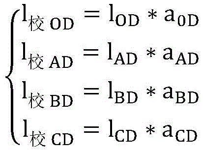
其中,lOD、lAD、lBD以及lCD为本实施例根据UWB测距模式获得基站与移动基站之间的UWB距离。Wherein, lOD , lAD , lBD , and lCD are the UWB distances between the base station and the mobile base station obtained according to the UWB ranging mode in this embodiment.
计算单元,用于根据线性校准后的通信参数,固定基站的定位坐标,以及移动基站与固定基站之间的距离,解算获得移动基站的坐标。The calculation unit is used to calculate and obtain the coordinates of the mobile base station according to the communication parameters after linear calibration, the positioning coordinates of the fixed base station, and the distance between the mobile base station and the fixed base station.
具体地,本实施例根据线性校准后的通信参数,基站的定位坐标,以及移动基站与基站之间的距离,解算获得移动基站的坐标的解算公式具体为:Specifically, in this embodiment, according to the communication parameters after linear calibration, the positioning coordinates of the base station, and the distance between the mobile base station and the base station, the calculation formula for obtaining the coordinates of the mobile base station is specifically:

其中,x,y,z坐标为D点在OABC平面对应的坐标。Wherein, the x, y, z coordinates are the corresponding coordinates of point D on the OABC plane.
优选地,固定基站还包括有:Preferably, the fixed base station also includes:
天线控制模块,与处理模块通信连接,用于根据移动基站的坐标获得固定基站的天线相对于移动基站的天线的方位角度,并根据方位角度,控制固定基站的天线始终指向移动基站的天线;以及用于根据方位角度,控制固定基站转动电机,使得固定基站的天线始终指向移动基站的天线;The antenna control module is communicated with the processing module, and is used to obtain the azimuth angle of the antenna of the fixed base station relative to the antenna of the mobile base station according to the coordinates of the mobile base station, and control the antenna of the fixed base station to always point to the antenna of the mobile base station according to the azimuth angle; and It is used to control the rotation motor of the fixed base station according to the azimuth angle, so that the antenna of the fixed base station always points to the antenna of the mobile base station;
数据库模块,与处理模块通信连接,用于建立基于主固定基站的RFID为参考的作业区域电子地图数据库。The database module is communicatively connected with the processing module, and is used to establish an electronic map database of the operation area based on the RFID of the main fixed base station as a reference.
优选地,固定基站的天线为定向天线,移动基站的天线为全向天线。Preferably, the antenna of the fixed base station is a directional antenna, and the antenna of the mobile base station is an omnidirectional antenna.
由于本实施例中移动基站时刻在改变位置,尽管移动基站的天线为全向天线,但固定基站的天线为定向天线,因此为了保证最佳的通信质量,固定基站的定向天线需要不断地跟随移动基站的全向天线角度变化而变化。具体地,本实施例根据解算的移动基站的坐标,首先获得固定基站的天线相对于移动基站的天线的方位角度,然后根据方位角度,控制固定基站转动电机,使得固定基站的天线始终指向移动基站的天线,从而使得固定基站与移动基站之间的信号保持最强,也即保证了最佳的通信质量。Since the mobile base station in this embodiment is changing position all the time, although the antenna of the mobile base station is an omnidirectional antenna, the antenna of the fixed base station is a directional antenna. Therefore, in order to ensure the best communication quality, the directional antenna of the fixed base station needs to constantly follow the mobile base station. The omnidirectional antenna angle changes. Specifically, this embodiment first obtains the azimuth angle of the antenna of the fixed base station relative to the antenna of the mobile base station according to the calculated coordinates of the mobile base station, and then controls the rotation motor of the fixed base station according to the azimuth angle so that the antenna of the fixed base station always points to the mobile base station. The antenna of the base station, so that the signal between the fixed base station and the mobile base station remains the strongest, that is, the best communication quality is guaranteed.
本实施例中,主固定基站与从固定基站读取GPS定位数据,并传输到主固定基站,主固定基站通过远程传输网络传输四个固定基站定位信息与RFID定位信息到服务器,服务器存储基于RFID标签信息的基站定位信息,并解算获得基于BD/GPS定位信息的以主固定基站为原点的作业区域基站平面坐标信息。在具体的实施过程中,人工或者遥控驾驶农机,根据作业载具特征,首先绕作业区域外圈一周,获得以主固定基站为原点的作业区域周界定位参数,并通过主固定基站上传到服务器,从而方便服务器建立基于主固定基站RFID为参考的作业区域电子地图数据库。In this embodiment, the main fixed base station and the slave fixed base station read GPS positioning data and transmit them to the main fixed base station. The main fixed base station transmits the positioning information of four fixed base stations and the RFID positioning information to the server through the remote transmission network. The base station positioning information of the tag information, and obtain the base station plane coordinate information of the work area with the main fixed base station as the origin based on the BD/GPS positioning information. In the specific implementation process, the agricultural machinery is manually or remotely driven, and according to the characteristics of the operating vehicle, it first circles around the outer circle of the operating area to obtain the perimeter positioning parameters of the operating area with the main fixed base station as the origin, and upload them to the server through the main fixed base station , so that it is convenient for the server to establish an electronic map database of the operation area based on the main fixed base station RFID as a reference.
本发明实施例提供的用于农业作业机械自动导航定位的UWB定位系统,通过调整固定基站的升降,并实时测量基站与移动基站的距离,将最短的距离对应的高度作为基站与移动基站处于同一水平的高度,通过基站的GPS/BD差分定位系统读取基站之间的GPS距离,并根据GPS距离解算获得基站的定位坐标以及基于基站的定位坐标,以及移动基站与基站之间的距离,解算获得移动基站的坐标,解决了现有农业作业机械自动导航定位精度低的技术问题,根据水田作业区域的近似水平作业环境,通过基站高程变化固定基站与移动基站定点距离测量最短原则,使得所有基站处于同一水平面,从而可通过固定基站的GPS/BD差分定位系统精准获得同一水平面的作业区域移动基站的定位坐标,并最终快速解算获得高精度的移动基站坐标。The UWB positioning system for automatic navigation and positioning of agricultural machinery provided by the embodiments of the present invention adjusts the lifting of the fixed base station and measures the distance between the base station and the mobile base station in real time, and takes the height corresponding to the shortest distance as the height corresponding to the base station and the mobile base station. The height of the level, read the GPS distance between the base stations through the GPS/BD differential positioning system of the base station, and calculate the positioning coordinates of the base station and the positioning coordinates based on the base station according to the GPS distance, as well as the distance between the mobile base station and the base station, The coordinates of the mobile base station are obtained through calculation, which solves the technical problem of low automatic navigation and positioning accuracy of the existing agricultural operation machinery. According to the approximate horizontal working environment of the paddy field operation area, the principle of the shortest distance between the fixed base station and the mobile base station is measured through the elevation change of the base station, so that All base stations are on the same horizontal plane, so that the positioning coordinates of the mobile base station in the work area on the same horizontal plane can be accurately obtained through the GPS/BD differential positioning system of the fixed base station, and finally the coordinates of the mobile base station with high precision can be quickly obtained through quick calculation.
此外,本发明实施例采用高性能差分卫星定位系统与局部定位系统的接口,实现作业田块的精确位置高精度定位以及通过基站间已知的高精度经纬度参数,获得UWB定位的校准误差系数,进行误差修正,进一步提高了移动基站坐标的解算精度。通过水田作业区域的近似水平作业环境,通过基站高程变化基站与移动基站定点距离测量最短原则,获得四个固定基站处于同一水平面;通过预先固定的RFID与主固定基站的RFID读写器,获得对应田块的编号,通过GPRS远程获得田块的四个固定基站的定位信息,实现了单次精确定位后的唯一关联定位参数获取。In addition, the embodiment of the present invention adopts the interface between the high-performance differential satellite positioning system and the local positioning system to realize the precise position and high-precision positioning of the working field and obtain the calibration error coefficient of UWB positioning through the known high-precision latitude and longitude parameters between base stations. The error correction is carried out to further improve the calculation accuracy of the coordinates of the mobile base station. Through the approximate horizontal working environment of the paddy field operation area and the principle of the shortest distance measurement between the base station and the mobile base station based on the elevation change of the base station, it is obtained that the four fixed base stations are on the same level; through the pre-fixed RFID and the RFID reader of the main fixed base station, the corresponding The number of the field, and the positioning information of the four fixed base stations of the field are obtained remotely through GPRS, which realizes the acquisition of the only associated positioning parameters after a single precise positioning.
另外,实施例一和实施例二中均采用了支撑支架,如附图4所示,支撑支架包括有内部呈空腔结构的粗升降杆1以及底端从粗升降杆1顶端嵌入其内部的丝升降杆2,粗升降杆1底端部套设有支撑基座3,丝升降杆2内部呈空腔结构且其上下端分别固定连接有上连接盖4和下连接盖5,粗升降杆1内部位于下连接盖5顶部面上设置有丝杆电机7,粗升降杆1内部沿其轴向设置有升降导向杆8。In addition, both
导向杆9下端面以及支撑基座3顶端面均沿其轴向开设有第一螺纹孔,导向杆9下端与支撑基座3顶端通过连接在第一螺纹孔内的升降导向螺母17连接;导向杆9上端面靠近中间位置以及下连接盖5靠近中间位置均沿其轴向开设有第二螺纹孔,导向杆9上端面靠近边缘位置以及下连接盖5靠近边缘位置均沿其轴向开设有长形通孔,导向杆9与丝升降杆2之间通过上端连接在丝杆电机7的输出轴上而下端连接在第二螺纹孔内的第二升降导向螺母18的丝杆15螺纹连接以及通过一端固定在下连接盖5而另一端套入长形通孔内的多根导向杆9连接。The lower end surface of the
丝升降杆2的上端部套设有转台10,该转台10的顶部还连接有呈蘑菇头状且用于通信与定位的信号盒11;转台10内顶部壁上沿转台10轴向固定设置有滑环触头12;上连接盖4的底部面上设置有舵机14,顶部面上固定设置有滑环电路板13,该舵机14与上连接盖4螺纹连接,其输出轴端部贯穿转台10内部以及内顶部壁并与转台10上端固定连接;上连接盖4的顶部面上固定设置有滑环电路板13,滑环电路板13分别与舵机14、丝杆电机7通信连接,用于控制丝杆电机7升降以及控制舵机14转动,滑环电路板13上还设置有滑环通道,该滑环通道与滑环触头12对应,用于触发滑环电路板13发出丝杆电机7升降以及舵机14转动的控制信号。The upper end of the
丝升降杆2内的丝杆电机7与舵机14之间设置有电池,丝升降杆2外部表面上还设置有太阳能电池板,丝升降杆2的上端外表面与转台10之间还设置有密封圈15。A battery is arranged between the
支撑基座3上部呈圆筒形且其内呈空腔结构,其内底部中间位置上沿其轴向开设有与丝杆15对应的第二螺纹孔16。The upper part of the
粗升降杆1、丝升降杆2以及转台10均呈圆筒形。Thick elevating
本发明实施例一和实施例二中所述的支撑支架,通过旋转转台10,转台10内的滑环触头12接触滑环通道,触发丝杆电机7转动的控制信号,并控制丝杆电机7正向转动或反向转动;丝杆电机7的动力输出轴输出动力至丝杆15,从而带动丝杆15旋转上升或下降;从而进一步带动与丝杆15固定连接于一体的下连接盖5、丝升降杆2上升或下降,从而实现支撑支架调整基站的升降。The support bracket described in
Claims (9)
Priority Applications (1)
| Application Number | Priority Date | Filing Date | Title |
|---|---|---|---|
| CN201910511714.1A CN110221329B (en) | 2019-06-13 | 2019-06-13 | A UWB positioning system for automatic navigation and positioning of agricultural machinery |
Applications Claiming Priority (1)
| Application Number | Priority Date | Filing Date | Title |
|---|---|---|---|
| CN201910511714.1A CN110221329B (en) | 2019-06-13 | 2019-06-13 | A UWB positioning system for automatic navigation and positioning of agricultural machinery |
Publications (2)
| Publication Number | Publication Date |
|---|---|
| CN110221329A CN110221329A (en) | 2019-09-10 |
| CN110221329B true CN110221329B (en) | 2023-06-27 |
Family
ID=67816853
Family Applications (1)
| Application Number | Title | Priority Date | Filing Date |
|---|---|---|---|
| CN201910511714.1A Active CN110221329B (en) | 2019-06-13 | 2019-06-13 | A UWB positioning system for automatic navigation and positioning of agricultural machinery |
Country Status (1)
| Country | Link |
|---|---|
| CN (1) | CN110221329B (en) |
Families Citing this family (7)
| Publication number | Priority date | Publication date | Assignee | Title |
|---|---|---|---|---|
| CN111580045A (en) * | 2020-05-29 | 2020-08-25 | 中国电建集团成都勘测设计研究院有限公司 | Internal self-positioning method of concrete vibration quality monitoring base station |
| CN112055043B (en) * | 2020-07-20 | 2021-09-28 | 江苏农林职业技术学院 | Accurately-positioned double-container seedling cultivation system and intelligent operation method thereof |
| CN114513848B (en) * | 2020-11-17 | 2023-11-14 | 比亚迪股份有限公司 | Indoor positioning method, indoor positioning system and positioning equipment |
| CN112698375B (en) * | 2020-12-14 | 2023-10-20 | 国网辽宁省电力有限公司鞍山供电公司 | A line drawing method for multi-domain dual positioning error elimination |
| CN114007261B (en) * | 2022-01-05 | 2022-06-10 | 华清科盛(北京)信息技术有限公司 | A three-dimensional positioning method and system of an aerial crane hook based on a UWB positioning system |
| CN115425389B (en) * | 2022-09-02 | 2025-03-21 | 大连海事大学 | An adaptive beam scanning antenna system based on differential ranging algorithm |
| CN116489826A (en) * | 2023-04-04 | 2023-07-25 | 珠海优特电力科技股份有限公司 | Positioning base station, positioning method, positioning system and storage medium |
Citations (2)
| Publication number | Priority date | Publication date | Assignee | Title |
|---|---|---|---|---|
| US6054950A (en) * | 1998-01-26 | 2000-04-25 | Multispectral Solutions, Inc. | Ultra wideband precision geolocation system |
| CN1969197A (en) * | 2004-02-17 | 2007-05-23 | 加迪公司 | Ultra wide band navigation system with mobile base stations |
Family Cites Families (2)
| Publication number | Priority date | Publication date | Assignee | Title |
|---|---|---|---|---|
| CN108255194A (en) * | 2018-01-08 | 2018-07-06 | 江苏工程职业技术学院 | A kind of agricultural plant protection unmanned plane precise positioning spraying control method based on UWB |
| CN109407659A (en) * | 2018-01-29 | 2019-03-01 | 大连理工大学 | Positioning method and system for tennis court robot |
-
2019
- 2019-06-13 CN CN201910511714.1A patent/CN110221329B/en active Active
Patent Citations (2)
| Publication number | Priority date | Publication date | Assignee | Title |
|---|---|---|---|---|
| US6054950A (en) * | 1998-01-26 | 2000-04-25 | Multispectral Solutions, Inc. | Ultra wideband precision geolocation system |
| CN1969197A (en) * | 2004-02-17 | 2007-05-23 | 加迪公司 | Ultra wide band navigation system with mobile base stations |
Also Published As
| Publication number | Publication date |
|---|---|
| CN110221329A (en) | 2019-09-10 |
Similar Documents
| Publication | Publication Date | Title |
|---|---|---|
| CN110221329B (en) | A UWB positioning system for automatic navigation and positioning of agricultural machinery | |
| CN110133698B (en) | UWB positioning method and system for automatic navigation and positioning of agricultural operation machinery | |
| EP2910896B1 (en) | Antenna attitude measurement method | |
| CN104040788B (en) | Electrical tilt antenna based on directional correction regulation and electrical tilt antenna system | |
| CN102175887B (en) | Mobile ultrasonic anemometer and method for measuring wind speed and direction | |
| CN201173773Y (en) | GPS RTK Total Station Measuring Instrument | |
| CN105445774B (en) | Measuring system and measuring method that a kind of GNSS is combined with laser ranging | |
| KR101482650B1 (en) | Apparatus and method for measuring angle of antennas of base station | |
| CN101672913A (en) | Laser three-point dynamic positioning method and system thereof | |
| CN107457784B (en) | GPS (Global positioning System) Beidou differential positioning and navigation method for substation inspection robot | |
| CN105873210B (en) | A kind of mobile trend hybrid locating method | |
| CN115953480B (en) | Laser radar internal reference calibration method and device | |
| CN113091695B (en) | An Elevation Measurement Method with Plane Positioning and Millimeter-Level Accuracy | |
| CN106772635B (en) | A kind of buried cable 3 D locating device and localization method to be crossed based on scanning | |
| CN107894771A (en) | A kind of dolly Omni-mobile control system and method | |
| CN106610268B (en) | Photoelectric mark relative position measuring device | |
| CN114739328A (en) | Sensing device for measuring ground fluctuation and floor flatness measuring robot | |
| CN112526483A (en) | Three-dimensional laser scanning device integrating spatial positioning and orienting method thereof | |
| CN109613567B (en) | A substation grounding grid test electrode locator based on global satellite navigation system | |
| KR20180110392A (en) | Hybrid location positioning method for indoor location measurement based on smart device | |
| CN113125861A (en) | Space unmanned aerial vehicle antenna near-far field measurement system | |
| KR101349384B1 (en) | Leveling survey system to confirm the position of constructure having the datum point | |
| CN212540715U (en) | A multifunctional ranging instrument | |
| CN111089568B (en) | Road sign calibration instrument based on RTK + camera | |
| CN113701754A (en) | Underground three-dimensional accurate positioning system |
Legal Events
| Date | Code | Title | Description |
|---|---|---|---|
| PB01 | Publication | ||
| PB01 | Publication | ||
| SE01 | Entry into force of request for substantive examination | ||
| SE01 | Entry into force of request for substantive examination | ||
| GR01 | Patent grant | ||
| GR01 | Patent grant |