CN109828599B - Aircraft working path planning method, control device and control device - Google Patents
Aircraft working path planning method, control device and control device Download PDFInfo
- Publication number
- CN109828599B CN109828599B CN201910015633.2A CN201910015633A CN109828599B CN 109828599 B CN109828599 B CN 109828599B CN 201910015633 A CN201910015633 A CN 201910015633A CN 109828599 B CN109828599 B CN 109828599B
- Authority
- CN
- China
- Prior art keywords
- point
- path
- safety
- distance
- auxiliary
- Prior art date
- Legal status (The legal status is an assumption and is not a legal conclusion. Google has not performed a legal analysis and makes no representation as to the accuracy of the status listed.)
- Active
Links
- 238000000034 method Methods 0.000 title claims abstract description 38
- 230000007704 transition Effects 0.000 claims abstract description 27
- 230000001133 acceleration Effects 0.000 claims description 20
- 230000032683 aging Effects 0.000 abstract 1
- 238000003032 molecular docking Methods 0.000 description 23
- 230000008859 change Effects 0.000 description 10
- 238000010586 diagram Methods 0.000 description 7
- 230000006870 function Effects 0.000 description 4
- RZVHIXYEVGDQDX-UHFFFAOYSA-N 9,10-anthraquinone Chemical compound C1=CC=C2C(=O)C3=CC=CC=C3C(=O)C2=C1 RZVHIXYEVGDQDX-UHFFFAOYSA-N 0.000 description 2
- 238000013459 approach Methods 0.000 description 1
- 238000012790 confirmation Methods 0.000 description 1
- 230000001066 destructive effect Effects 0.000 description 1
- 230000000694 effects Effects 0.000 description 1
- 230000007613 environmental effect Effects 0.000 description 1
- 238000012986 modification Methods 0.000 description 1
- 230000004048 modification Effects 0.000 description 1
- 230000008685 targeting Effects 0.000 description 1
- 238000012795 verification Methods 0.000 description 1
Images


Classifications
-
- G—PHYSICS
- G08—SIGNALLING
- G08G—TRAFFIC CONTROL SYSTEMS
- G08G5/00—Traffic control systems for aircraft
- G08G5/30—Flight plan management
-
- B—PERFORMING OPERATIONS; TRANSPORTING
- B64—AIRCRAFT; AVIATION; COSMONAUTICS
- B64U—UNMANNED AERIAL VEHICLES [UAV]; EQUIPMENT THEREFOR
- B64U10/00—Type of UAV
- B64U10/10—Rotorcrafts
-
- G—PHYSICS
- G05—CONTROLLING; REGULATING
- G05D—SYSTEMS FOR CONTROLLING OR REGULATING NON-ELECTRIC VARIABLES
- G05D1/00—Control of position, course, altitude or attitude of land, water, air or space vehicles, e.g. using automatic pilots
- G05D1/10—Simultaneous control of position or course in three dimensions
-
- G—PHYSICS
- G08—SIGNALLING
- G08G—TRAFFIC CONTROL SYSTEMS
- G08G5/00—Traffic control systems for aircraft
- G08G5/20—Arrangements for acquiring, generating, sharing or displaying traffic information
- G08G5/22—Arrangements for acquiring, generating, sharing or displaying traffic information located on the ground
-
- G—PHYSICS
- G08—SIGNALLING
- G08G—TRAFFIC CONTROL SYSTEMS
- G08G5/00—Traffic control systems for aircraft
- G08G5/20—Arrangements for acquiring, generating, sharing or displaying traffic information
- G08G5/26—Transmission of traffic-related information between aircraft and ground stations
-
- G—PHYSICS
- G08—SIGNALLING
- G08G—TRAFFIC CONTROL SYSTEMS
- G08G5/00—Traffic control systems for aircraft
- G08G5/30—Flight plan management
- G08G5/32—Flight plan management for flight plan preparation
-
- G—PHYSICS
- G08—SIGNALLING
- G08G—TRAFFIC CONTROL SYSTEMS
- G08G5/00—Traffic control systems for aircraft
- G08G5/50—Navigation or guidance aids
- G08G5/52—Navigation or guidance aids for take-off
-
- G—PHYSICS
- G08—SIGNALLING
- G08G—TRAFFIC CONTROL SYSTEMS
- G08G5/00—Traffic control systems for aircraft
- G08G5/50—Navigation or guidance aids
- G08G5/55—Navigation or guidance aids for a single aircraft
-
- B—PERFORMING OPERATIONS; TRANSPORTING
- B64—AIRCRAFT; AVIATION; COSMONAUTICS
- B64U—UNMANNED AERIAL VEHICLES [UAV]; EQUIPMENT THEREFOR
- B64U2201/00—UAVs characterised by their flight controls
- B64U2201/10—UAVs characterised by their flight controls autonomous, i.e. by navigating independently from ground or air stations, e.g. by using inertial navigation systems [INS]
-
- G—PHYSICS
- G08—SIGNALLING
- G08G—TRAFFIC CONTROL SYSTEMS
- G08G5/00—Traffic control systems for aircraft
- G08G5/50—Navigation or guidance aids
- G08G5/57—Navigation or guidance aids for unmanned aircraft
-
- G—PHYSICS
- G08—SIGNALLING
- G08G—TRAFFIC CONTROL SYSTEMS
- G08G5/00—Traffic control systems for aircraft
- G08G5/50—Navigation or guidance aids
- G08G5/59—Navigation or guidance aids in accordance with predefined flight zones, e.g. to avoid prohibited zones
Landscapes
- Engineering & Computer Science (AREA)
- Aviation & Aerospace Engineering (AREA)
- Physics & Mathematics (AREA)
- General Physics & Mathematics (AREA)
- Remote Sensing (AREA)
- Mechanical Engineering (AREA)
- Radar, Positioning & Navigation (AREA)
- Automation & Control Theory (AREA)
- Traffic Control Systems (AREA)
- Control Of Position, Course, Altitude, Or Attitude Of Moving Bodies (AREA)
- Navigation (AREA)
- Management, Administration, Business Operations System, And Electronic Commerce (AREA)
Abstract
本发明涉及一种飞行器作业路径规划方法以及控制装置和控制设备,其中包括以下步骤:获取停靠点,作业点以及安全点,所述安全点周围的安全距离范围内没有障碍物;规划所述停靠点与安全点之间的第一路径、所述安全点与作业点之间的第二路径,使得所述停靠点和所述作业点之间的路径按照平滑过渡的方式经过所述安全点。本发明令无人机飞行器飞行的路径通过安全点过渡,实现安全进入或离开作业地块;并且飞行器按照第三路径过渡的路径飞行,无需在安全点停留,以提高飞行器的飞行速度,提高作业时效;由于飞行器能够避免在安全点停顿,从而避免对作业目标的伤害。
The invention relates to a method for planning a working path of an aircraft, a control device and a control device, which include the following steps: acquiring a stop point, an operation point and a safety point, and there are no obstacles within a safe distance around the safety point; planning the stop point The first path between the point and the safety point, and the second path between the safety point and the work point, so that the path between the stop point and the work point passes through the safety point in a smooth transition manner. The present invention makes the flight path of the unmanned aerial vehicle transit through the safety point, so as to safely enter or leave the operation plot; and the aircraft flies according to the transition path of the third path without stopping at the safety point, so as to improve the flight speed of the aircraft and improve the operation. Aging; because the aircraft can avoid stopping at a safe point, so as to avoid damage to the operation target.
Description
技术领域technical field
本发明属于飞行器领域,具体涉及一种飞行器作业路径规划方法以及控制装置,特别涉及一种无人机作业路径规划方法以及控制装置和控制设备。The invention belongs to the field of aircraft, in particular to a method for planning a working path of an aircraft and a control device, and in particular to a method for planning a working path of an unmanned aerial vehicle, a control device and a control device.
背景技术Background technique
飞行器在进入作业地块按照规划的路线进行作业时,往往从起飞点直接沿直线飞行到作业路线的第一个航点,如果此时在地块边界上存在树木、电线杆等障碍物,而无人机不具备自主避障功能、或者自主避障功能效果不佳,很容易与地块边界上的障碍物发生撞击事故,即使具有较好的自主避障功能,也可能需要花费较长的时间以及较大的功耗来执行自主避障功能以到达作业地块内,对于降落点,同样如此。When the aircraft enters the operation plot and operates according to the planned route, it often flies in a straight line from the take-off point to the first waypoint of the operation route. If there are obstacles such as trees and telephone poles on the boundary of the plot, and The drone does not have the function of autonomous obstacle avoidance, or the effect of the autonomous obstacle avoidance function is not good, and it is easy to collide with the obstacles on the boundary of the plot. Even if it has a good autonomous obstacle avoidance function, it may take a long time. Time and large power consumption to perform autonomous obstacle avoidance function to reach the operating field, and the same is true for the landing point.
鉴于此,提出一种更高效、更安全的飞行器作业路径规划方法是本发明所要研究的课题。In view of this, it is the subject of the present invention to propose a more efficient and safer aircraft operating path planning method.
发明内容SUMMARY OF THE INVENTION
本发明提供一种飞行器作业路径规划方法,其目的是为了解决现有技术无法安全快速进入作业地块的问题。The present invention provides a method for planning a working path of an aircraft, the purpose of which is to solve the problem that the prior art cannot safely and quickly enter the working plot.
为达到上述目的,本发明采用的技术方案是:一种飞行器作业路径规划方法,所述方法包括:In order to achieve the above object, the technical solution adopted in the present invention is: a method for planning a working path of an aircraft, the method comprising:
获取停靠点,作业点以及安全点,所述安全点周围的安全距离范围内没有障碍物;Acquire stopping points, operating points and safety points, and there are no obstacles within a safe distance around the safety points;
规划所述停靠点与安全点之间的第一路径、所述安全点与作业点之间的第二路径,使得所述停靠点和所述作业点之间的路径按照平滑过渡的方式经过所述安全点。Plan the first path between the stop point and the safety point, and the second path between the safety point and the operation point, so that the path between the stop point and the operation point passes through all the points in a smooth transition manner. the safety point.
上述技术方案中的有关内容解释如下:The relevant contents in the above technical solutions are explained as follows:
1、上述方案中,所述方法还包括:1. In the above scheme, the method further comprises:
获取第一路径上的第一辅助点,所述第一辅助点到所述安全点的距离小于或等于所述安全距离并且小于或等于第二路径上所述安全点到所述作业点的距离,以所述第一辅助点为切点,且以所述第一路径和第二路径为切线规划一靠近所述安全点的圆弧为第三路径,使得第一路径、第二路径之间通过所述第三路径过渡。Obtain the first auxiliary point on the first path, the distance from the first auxiliary point to the safety point is less than or equal to the safety distance and less than or equal to the distance from the safety point to the operation point on the second path , take the first auxiliary point as the tangent point, and take the first path and the second path as the tangent to plan an arc close to the safety point as the third path, so that the distance between the first path and the second path is Transition through the third path.
2、上述方案中,所述停靠点位于作业地块外,所述安全点位于作业地块内,所述作业地块由若干边界围成,所述第一辅助点到所述安全点的距离小于或等于所述安全点到所述第一路径与边界相交的点的距离。2. In the above solution, the docking point is located outside the operation plot, the safety point is located in the operation plot, the operation plot is surrounded by several boundaries, and the distance from the first auxiliary point to the safety point is Less than or equal to the distance from the safe point to the point where the first path intersects the boundary.
3、上述方案中,所述第三路径通过以下至少两种方式获取:3. In the above solution, the third path is obtained in at least two of the following ways:
获取第二路径上的距离所述安全点为所述第一辅助点到所述安全点距离的第二辅助点,以第一辅助点和第二辅助点为切点,规划一靠近所述安全点的圆弧为第三路径;Obtain the distance on the second path. The safety point is the second auxiliary point of the distance from the first auxiliary point to the safety point. Taking the first auxiliary point and the second auxiliary point as the tangent points, plan an approach to the safety point. The arc of the point is the third path;
或者,获取第一路径和第二路径的角平分线,获取所述第一路径上以所述第一辅助点为垂足的垂线与所述角平分线的交点为圆心,以圆心到所述第一辅助点的垂直距离为半径,规划一靠近所述安全点的圆弧为第三路径。Or, obtain the angle bisectors of the first path and the second path, obtain the intersection of the vertical line with the first auxiliary point as the vertical foot on the first path and the angle bisector as the center of the circle, and take the center of the circle to the The vertical distance of the first auxiliary point is the radius, and an arc close to the safety point is planned as the third path.
4、上述方案中,所述第三路径的半径为r=s*tan(θ/2),其中s为所述第一路径上第一辅助点到所述安全点的距离,θ为所述第一路径和第二路径之间的夹角,所述第三路径的半径r≥1m。4. In the above solution, the radius of the third path is r=s*tan(θ/2), where s is the distance from the first auxiliary point on the first path to the safety point, and θ is the The angle between the first path and the second path, the radius r of the third path is ≥ 1m.
5、上述方案中,获取第一路径上所述停靠点到所述第一辅助点的距离为第一限速距离,获取第二路径上所述作业点到第三路径和第二路径的切点的距离为第二限速距离,所述第一限速距离和/或第二限速距离大于等于
6、上述方案中,所述停靠点为起飞点或降落点。6. In the above solution, the stop point is a take-off point or a landing point.
7、上述方案中,所述作业点包括作业任务路径中的任一点。7. In the above solution, the operation point includes any point in the path of the operation task.
8、上述方案中,按照平滑过渡的方式指的是路径经过安全点的时候没有转折点。8. In the above scheme, the smooth transition means that there is no turning point when the path passes through the safety point.
为达到上述目的,本发明采用的另一种技术方案是:一种控制装置,包括:In order to achieve the above object, another technical solution adopted by the present invention is: a control device, comprising:
获取模块,获取停靠点、作业点以及安全点,所述安全点周围的安全距离范围内没有障碍物;an acquisition module to acquire a stop point, an operation point and a safety point, and there are no obstacles within a safe distance around the safety point;
规划模块,规划所述停靠点与安全点之间的第一路径、所述安全点与作业点之间的第二路径,使得所述停靠点和所述安全点之间的路径按照平滑过渡的方式经过所述安全点。A planning module, planning the first path between the stop point and the safety point, and the second path between the safety point and the operation point, so that the path between the stop point and the safety point follows a smooth transition. way past the safe point.
1、上述方案中,包括:所述规划模块还获取第一路径上的第一辅助点,所述第一辅助点到所述安全点的距离小于或等于所述安全距离并且小于或等于第二路径上所述安全点到所述作业点的距离,以所述第一辅助点为切点,且以所述第一路径和第二路径为切线规划一靠近所述安全点的圆弧为第三路径,使得第一路径、第二路径之间通过所述第三路径过渡。1. In the above solution, including: the planning module also obtains a first auxiliary point on the first path, and the distance from the first auxiliary point to the safety point is less than or equal to the safety distance and less than or equal to the second auxiliary point. The distance from the safety point on the path to the operating point, taking the first auxiliary point as the tangent point, and taking the first path and the second path as the tangent, plan an arc close to the safety point as the first Three paths, so that the transition between the first path and the second path passes through the third path.
为达到上述目的,本发明采用的另一种技术方案是:一种控制设备,其设置于飞行器或者移动终端,包括:In order to achieve the above purpose, another technical solution adopted by the present invention is: a control device, which is arranged on an aircraft or a mobile terminal, including:
一个或多个处理器;one or more processors;
存储器;memory;
一个或多个应用程序,其中所述一个或多个应用程序被存储在所述存储器中并被配置为由所述一个或多个处理器执行,所述一个或多个程序配置用于:执行所述飞行器路径规划方法的步骤。one or more application programs, wherein the one or more application programs are stored in the memory and configured to be executed by the one or more processors, the one or more programs are configured to: execute The steps of the aircraft path planning method.
1、上述方案中,所述停靠点还可以是用户放置无人机的位置、或者是规划的起始点或降落点等等。1. In the above solution, the docking point may also be the position where the user places the drone, or the planned starting point or landing point, and so on.
由于上述技术方案运用,本发明与现有技术相比的优点如下:Due to the application of the above-mentioned technical solutions, the advantages of the present invention compared with the prior art are as follows:
(1)本发明令无人机飞行器飞行的路径通过安全点过渡,实现安全进入或离开作业地块。(1) The present invention makes the flight path of the unmanned aerial vehicle transit through the safety point, so as to realize safe entry or departure from the operation plot.
(2)本发明的飞行器按照第三路径过渡的路径飞行,无需在安全点停留,以提高飞行器的飞行速度,提高作业时效。(2) The aircraft of the present invention flies according to the transition path of the third path, and does not need to stop at a safe point, so as to increase the flight speed of the aircraft and improve the operation efficiency.
(3)本发明的飞行器能够避免在安全点停顿,从而避免对作业目标的伤害。(3) The aircraft of the present invention can avoid stopping at a safe point, thereby avoiding damage to the work target.
综上,本发明的飞行器通过安全点进入或离开作业地块,无需在安全点停留,而是沿着圆弧飞行,在圆弧上边飞行边改变航向,以使航向与圆弧切线方向一致,此后再飞向作业点。本发明一方面能够提高作业时效,另一方面不会对安全点下方的作业目标产生破坏作用。To sum up, the aircraft of the present invention enters or leaves the operation site through the safety point, and does not need to stay at the safety point, but flies along the arc, and changes the heading while flying on the arc, so that the heading is consistent with the tangential direction of the arc, Then fly to the work point. On the one hand, the present invention can improve the working efficiency, and on the other hand, it will not cause damage to the working target below the safety point.
附图说明Description of drawings
附图1为本发明一种可选实施例一的路径规划方法的示意图;FIG. 1 is a schematic diagram of a path planning method according to an optional embodiment 1 of the present invention;
附图2为本发明一种可选实施例二的路径规划方法的示意图;FIG. 2 is a schematic diagram of a path planning method according to an optional embodiment 2 of the present invention;
附图3为本发明一种可选实施例三的路径规划方法的示意图;3 is a schematic diagram of a path planning method according to an optional embodiment 3 of the present invention;
附图4为本发明的一种可选实施例的控制装置的结构框图。FIG. 4 is a structural block diagram of a control apparatus according to an optional embodiment of the present invention.
具体实施方式Detailed ways
下面结合附图及实施例对本发明作进一步描述:Below in conjunction with accompanying drawing and embodiment, the present invention is further described:
本发明公开一种飞行器作业路径规划方法,以解决现有技术中无法实现安全快速通过作业边界的问题。具体方法包括:The invention discloses a method for planning a working path of an aircraft, so as to solve the problem in the prior art that the safe and rapid passing of the working boundary cannot be achieved. Specific methods include:
S100:获取停靠点和作业点,以及获取安全点,所述安全点周围的安全距离范围内没有障碍物,即在小于或等于安全距离的范围内,没有影响飞行的障碍物,保证飞行器可以安全飞行,安全距离可以2m,2.5m,3m,3.5m,4m等等,可以根据飞行器的固有参数和/或环境条件等而设定,此处不作限制。停靠点为起飞点或降落点,可以是飞行过程中的自动判定或者人工判定的点,也可以是静止时候的点,此处不作限制。停靠点、安全点可以位于作业地块内,或者作业地块外,或者作业地块上,此处也不作限制。作业点包括作业任务路径中的任一点,可以根据不同的作业任务实时或预先自动或手动规划确认,当作业地块较大需要进行连续作业时,作业点可以是上一次作业的结束点,如此,可以自主快速实现路径规划。一般情况下,无法保证停靠点和作业点之间的路径上没有障碍物,如此,设置安全点,安全点在安全范围内没有障碍物,即没有电线杆、土丘、树枝等影响飞行安全的障碍物,只要在安全点的安全距离内,飞行器可以安全穿过飞行或穿过作业边界等,而不会碰到障碍物,使得规划的路径更加安全。S100: Acquire a stop point and an operation point, and acquire a safety point. There are no obstacles within a safe distance around the safety point, that is, within a range less than or equal to the safety distance, there are no obstacles that affect flight, so that the aircraft can be safely During flight, the safe distance can be 2m, 2.5m, 3m, 3.5m, 4m, etc., which can be set according to the inherent parameters of the aircraft and/or environmental conditions, etc., which are not limited here. The stop point is the take-off point or the landing point, which can be automatically determined or manually determined during the flight, or the point when it is stationary, which is not limited here. The docking point and safety point can be located in the work plot, outside the work plot, or on the work plot, and there are no restrictions here. The operation point includes any point in the job task path, which can be confirmed by automatic or manual planning in real time or in advance according to different operation tasks. When the operation plot is large and continuous operation is required, the operation point can be the end point of the previous operation, so , which can independently and quickly realize path planning. Under normal circumstances, it cannot be guaranteed that there are no obstacles on the path between the stop point and the operating point. In this way, a safety point is set up, and the safety point has no obstacles within the safe range, that is, there are no telephone poles, mounds, branches, etc. that affect flight safety. Obstacles, as long as the aircraft is within a safe distance of the safety point, the aircraft can safely pass through the flight or the operation boundary without encountering obstacles, making the planned path safer.
S200:规划所述停靠点与安全点之间的第一路径、所述安全点与作业点之间的第二路径,使得停靠点和安全点之间的路径按照平滑过渡的方式经过安全点。S200: Plan a first path between the stop point and the safety point, and a second path between the safety point and the work point, so that the path between the stop point and the safety point passes through the safety point in a smooth transition manner.
在某些实施例中,在停靠点A、安全点B、作业点C这三个点之间规划路径,形成直线飞行轨迹,并且在安全点附近平滑过渡使得规划的路径没有转折点,由作业地块外的任意停靠点A直线飞往安全点B附近,安全点B的安全距离范围内没有障碍物,再由安全点B附近直线飞往规划的路线的任意作业点C,当飞行器从A飞往B时,其速度会加速、减速至零到达B,从B飞往C时,其速度从零开始加速。如此规划的路径,在停靠点和作业点之间经过安全点,使得无人机在停靠点和作业点之间沿着第一路径和第二路径飞行(依次从第一路径到第二路径或依次从第二路径到第一路径),可以实现自主安全通过作业边界。需要说明的是,在规划路径中,还可以包括预先设置路径中的障碍物信息,以确保规划的航线上完全没有障碍物,更加提高飞行的安全性。In some embodiments, a route is planned between the three points of the stop point A, the safety point B, and the operation point C to form a straight flight trajectory, and the smooth transition near the safety point makes the planned path have no turning points, and is determined by the operation site. Any stop point A outside the block will fly straight to the vicinity of safety point B, and there are no obstacles within the safe distance of safety point B, and then fly straight from the vicinity of safety point B to any operating point C of the planned route. When going to B, its speed will accelerate and decelerate to zero to reach B, and when going from B to C, its speed will accelerate from zero. The path thus planned passes through the safety point between the stop point and the operation point, so that the drone flies along the first path and the second path (sequentially from the first path to the second path or From the second path to the first path in turn), autonomous and safe passage through the working boundary can be achieved. It should be noted that, in the planned route, the obstacle information in the preset route may also be included to ensure that there are no obstacles on the planned route, and the flight safety is further improved.
在某些实施例中,当停靠点位于作业地块外,作业地块由若干边界围成,此时,安全点B还可以位于作业地块内而与任意边界的距离大于或等于预设阈值,这样,可以保证安全点的位置不会接触作业边界,可以保证飞行器安全地从停靠点飞往安全点的路径中,不会碰触到未知的作业边界,而造成未知的碰撞事故。而在其他一些实施例中,当停靠点还可以位于作业地块内,而安全点也位于作业地块内与任意边界的距离大于或等于预设阈值,这样,也可以保证飞行器安全地从停靠点飞往安全点,再从安全点飞往作业点。In some embodiments, when the stop point is located outside the work area, and the work area is surrounded by several boundaries, at this time, the safety point B may also be located within the work area and the distance from any boundary is greater than or equal to a preset threshold , in this way, it can be ensured that the position of the safety point will not touch the operation boundary, and it can be ensured that the aircraft will not touch the unknown operation boundary and cause unknown collision accidents in the path from the docking point to the safety point. In some other embodiments, when the docking point can also be located in the operation area, and the safety point is also located in the operation area and the distance from any boundary is greater than or equal to a preset threshold, in this way, the aircraft can also be safely parked from the docking point. Point to the safe point, and then from the safe point to the operating point.
进一步地,当安全点位于作业地块内时,安全点与任意边界的距离可以大于或等于预设阈值,可以理解为安全点与作业地块的任意边界的距离均大于或等于第一阈值,一般的,第一阈值包括1.5m,2m,3m,3.5m,或者4m等等,可以根据飞行器自身的固有参数进行设定,只要保证飞行器的半个机身不会碰撞到地块边界即可,此处不作限制。进一步地,安全点还可以与停靠点的最近边界的距离大于或等于第二阈值,第二阈值包括2.5m,3m,3.5m,或者4m等等,只要保证飞行器能安全通过作业边界并可以适当改变方向即可,此处不作限制。如此,在保证飞行器能够从停靠点能够安全进入地块边界的情况下,安全点为设置于作业地块内与作业地块边界以及障碍物呈一定距离的点,当停靠点和安全点之间的路径无障碍物时,飞行器在停靠点和安全点之间的飞行路径上安全通过作业边界,且不会与其他任意边界碰撞,同时,由于安全点处于作业地块内,可以从安全点安全地飞往作业地块内的任意一个作业点。安全点可以根据停靠点,以及作业地块边界、障碍物信息实时计算的,保证通过作业地块边界的安全性。Further, when the safety point is located in the operation plot, the distance between the safety point and any boundary may be greater than or equal to the preset threshold, which can be understood as the distance between the safety point and any boundary of the operation plot is greater than or equal to the first threshold, Generally, the first threshold includes 1.5m, 2m, 3m, 3.5m, or 4m, etc., which can be set according to the inherent parameters of the aircraft itself, as long as it is ensured that the half fuselage of the aircraft will not collide with the boundary of the plot. , there is no restriction here. Further, the distance between the safety point and the nearest boundary of the stop point may be greater than or equal to a second threshold, the second threshold includes 2.5m, 3m, 3.5m, or 4m, etc., as long as the aircraft can safely pass through the operating boundary and can be properly You can change the direction, there is no restriction here. In this way, under the condition that the aircraft can safely enter the boundary of the plot from the docking point, the safety point is a point set in the operation plot at a certain distance from the boundary of the operation plot and obstacles. When the distance between the docking point and the safety point is When there are no obstacles on the path between the stop point and the safety point, the aircraft can safely pass the operation boundary on the flight path between the stop point and the safety point, and will not collide with any other boundary. fly to any operation point within the operation plot. The safety point can be calculated in real time according to the stop point, the boundary of the operation plot, and the obstacle information, so as to ensure the safety of passing the boundary of the operation plot.
在某些实施例中,飞行器在经过安全点的路径上安全飞行,使其可以安全从停靠点经过安全点快速地达到作业点,还包括如下步骤:In some embodiments, the aircraft flies safely on the path passing through the safety point, so that it can safely and quickly reach the work point from the docking point through the safety point, further comprising the following steps:
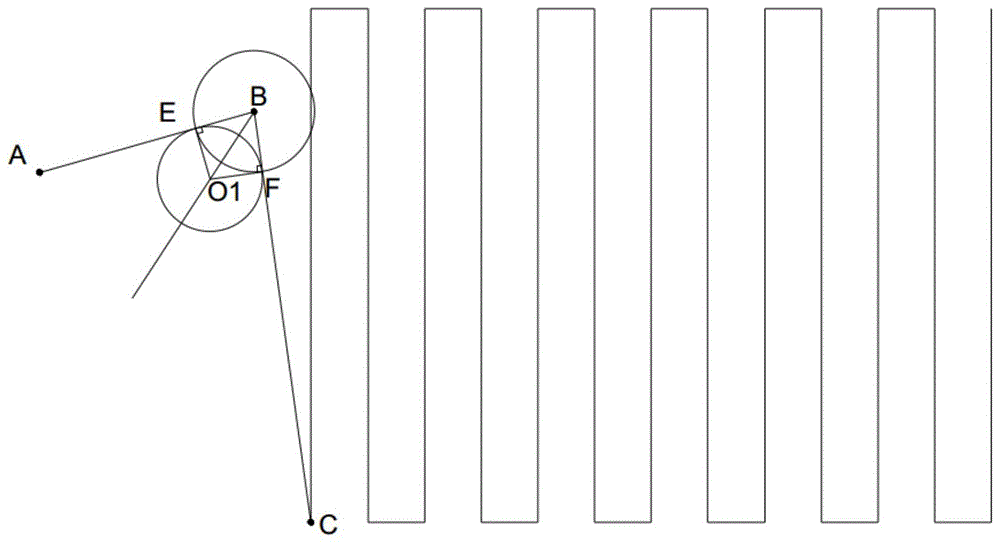
S300:获取第一路径上的第一辅助点,第一辅助点到安全点的距离小于或等于安全距离并且小于或等于第二路径上安全点到作业点的距离,以第一辅助点为切点,且以第一路径和第二路径为切线规划一靠近安全点的圆弧为第三路径,使得第一路径、第二路径之间通过第三路径平滑过渡。此时,停靠点和安全点之间的路径仍旧经过安全点,区别在于,此时规划的路径会处于安全点附近,偏离安全点,使得路径经过安全点的时候没有转折点。S300: Acquire a first auxiliary point on the first path, the distance from the first auxiliary point to the safety point is less than or equal to the safety distance and less than or equal to the distance from the safety point to the working point on the second path, taking the first auxiliary point as the cutoff point The first path and the second path are used as tangents to plan an arc close to the safety point as the third path, so that the first path and the second path are smoothly transitioned through the third path. At this time, the path between the stop point and the safety point still passes through the safety point. The difference is that the planned path will be near the safety point and deviate from the safety point, so that there is no turning point when the path passes through the safety point.
如果规划的路径在安全点B没有平滑过渡,则在安全点B需要旋转使其航向从A到B的方向变成从B到C的方向,在安全点B会有几秒的停顿时间,也就是说,每一次的起飞和降落都要耗费这些时间,在针对大田作业时,由于电源的限制,会有若干个架次的作业,此时在安全点会花费更多的时间,这大大降低了作业的时效性。同时,在针对同一个作业地块时,一般其安全点固定,如果在同一个安全点上悬停的时间过长,飞行器桨叶高速旋转形成的下压风场会影响其下方的作业目标的生长,甚至会对其造成破坏。简而言之,飞行器从起飞点飞往作业点的中间,会在安全点上停留,在安全点上旋转以改变飞行器航向,以飞向作业点,这影响了作业时效,同时由于重复多次的停留会对安全点下方的作业目标产生破坏作用。基于此,通过设计第三路径实现第一路径和第二路径之间的过渡,使得飞行器在规划的路径上可以实现快速飞行作业,提高了作业时效,不会对作业目标产生危害。If the planned path does not have a smooth transition at the safe point B, it needs to rotate at the safe point B to change its course from the direction A to B to the direction from B to C, and there will be a pause time of a few seconds at the safe point B. That is to say, each take-off and landing will consume this time. When working in the field, due to the limitation of power supply, there will be several sorties of operations. At this time, it will take more time at the safe point, which greatly reduces the Timeliness of work. At the same time, when targeting the same operating area, the safety point is generally fixed. If the hovering time on the same safety point is too long, the downward pressure wind field formed by the high-speed rotation of the aircraft blades will affect the operation target below it. grow and even destroy it. In short, from the take-off point to the middle of the operation point, the aircraft will stop at the safety point, and rotate on the safety point to change the course of the aircraft to fly to the operation point, which affects the operation time. The stay will have a destructive effect on the operation target below the safety point. Based on this, the transition between the first path and the second path is realized by designing the third path, so that the aircraft can achieve fast flight operations on the planned path, which improves the operation time and does not cause harm to the operation target.
需要说明的是,不管安全点、停靠点与作业地块的位置关系,只要在安全距离范围内,没有障碍物,并且第一辅助点到安全点的距离小于或等于安全距离且小于或等于第二路径上安全点到作业点的距离,即可保证第三路径处于无障碍区,可以实现从停靠点到作业点的路径上安全飞行。一方面,第一辅助点到安全点的距离小于或等于安全距离,以保证第三路径在安全距离内而没有障碍物,另一方面,第一辅助点到安全点的距离小于或等于第二路径上安全点到作业点的距离,可以使第三路径和第二路径有效过渡,防止安全点到作业点的距离过短而无法实现过渡,保证规划路径的有效性。It should be noted that, regardless of the positional relationship between the safety point, the stop point and the operation plot, as long as there are no obstacles within the safety distance, and the distance from the first auxiliary point to the safety point is less than or equal to the safety distance and less than or equal to the first auxiliary point. The distance from the safety point on the second path to the operating point can ensure that the third path is in the barrier-free area, and can achieve safe flight on the path from the stop point to the operating point. On the one hand, the distance from the first auxiliary point to the safety point is less than or equal to the safety distance to ensure that the third path is within the safety distance without obstacles; on the other hand, the distance from the first auxiliary point to the safety point is less than or equal to the second The distance from the safety point to the operating point on the path can effectively transition the third path and the second path, preventing the distance from the safety point to the operating point from being too short to realize the transition, and ensuring the effectiveness of the planned path.
在某些实施例中,停靠点位于作业地块外,安全点位于作业地块内,第一辅助点到安全点的距离小于或等于安全点到第一路径与边界相交的点的距离,使得第三路径可以位于作业地块内,而不会与作业边界相交,提高了飞行过渡的安全性。当停靠点位于作业地块外,安全点位于作业地块内时,停靠点和安全点之间的第一路径必定与作业边界相交,此时,为了提高飞行的安全性,可以使得第一辅助点位于作业地块内部,而防止第三路径与作业边界相交而造成未知的安全隐患。In some embodiments, the stop is located outside the work lot, the safety point is located within the work lot, and the distance from the first auxiliary point to the safety point is less than or equal to the distance from the safety point to the point where the first path intersects the boundary, such that The third path can be located within the working plot without intersecting the working boundary, improving the safety of flight transitions. When the docking point is outside the operation area and the safety point is located in the operation area, the first path between the docking point and the safety point must intersect the operation boundary. At this time, in order to improve the safety of the flight, the first auxiliary The point is located inside the operation plot, preventing the third path from intersecting the operation boundary and causing unknown safety hazards.
进一步地,第三路径通过以下至少两种方式获取:获取第二路径上的距离所述安全点为所述第一辅助点到所述安全点距离的第二辅助点,以第一辅助点和第二辅助点为切点,规划一靠近所述安全点的圆弧为第三路径;或者,获取第一路径和第二路径的角平分线,获取所述第一路径上以所述第一辅助点为垂足的垂线与所述角平分线的交点为圆心,以圆心到所述第一辅助点的垂直距离为半径,规划一靠近所述安全点的圆弧为第三路径。确定第三路径的方法不以此为限,只要能够保证第三路径处于作业地块内即可。Further, the third path is obtained in at least two of the following ways: obtaining the distance from the safety point on the second path to the second auxiliary point of the distance from the first auxiliary point to the safety point, using the first auxiliary point and the second auxiliary point. The second auxiliary point is the tangent point, and an arc close to the safety point is planned as the third path; or, the angle bisector of the first path and the second path is obtained, and the first path on the first path is obtained with the first The intersection of the vertical line where the auxiliary point is the vertical foot and the angle bisector is the center of the circle, and the vertical distance from the center of the circle to the first auxiliary point is the radius, and an arc close to the safety point is planned as the third path. The method for determining the third path is not limited to this, as long as the third path can be guaranteed to be within the work plot.
进一步地,第三路径的半径为r=s*tan(θ/2),其中s为第一路径上第一辅助点到安全点的距离,θ为第一路径和第二路径之间的夹角,第三路径的半径r≥1m。r还可以≥1.5m或≥2m或≥2.5m或≥3m等,用户可以根据作业需要或环境需要或飞行器性能对r进行设置,此处不作限制。Further, the radius of the third path is r=s*tan(θ/2), where s is the distance from the first auxiliary point on the first path to the safety point, and θ is the clamp between the first path and the second path. angle, the radius of the third path r≥1m. r can also be ≥1.5m or ≥2m or ≥2.5m or ≥3m, etc. The user can set r according to the needs of the operation or the environment or the performance of the aircraft, which is not limited here.
进一步地,获取第一路径上停靠点到第一辅助点的距离为第一限速距离,获取第二路径上作业点到第三路径和第二路径的切点的距离为第二限速距离,第一限速距离和第二限速距离大于等于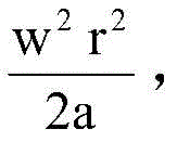
根据上述的作业路径规划方法,飞行器在停靠点和作业点之间沿着第一路径、第三路径、第二路径飞行,以实现快速飞行。无需在安全点停留,不会对作业目标产生危害。需要说明的是,飞行器可以依次沿着第一路径、第三路径、第二路径从停靠点飞向作业的,也可以依次沿着第二路径、第三路径、第一路径从作业点飞向停靠点,可以根据起飞或者降落来调整,只要保证第一路径和第二路径之间经过第三路径的过渡即可,此处不作限制。According to the above working path planning method, the aircraft flies along the first path, the third path and the second path between the docking point and the working point, so as to achieve fast flight. There is no need to stop at a safe point, and it will not cause harm to the work target. It should be noted that the aircraft can follow the first path, the third path, and the second path in sequence from the docking point to the work point, or it can follow the second path, the third path, and the first path in sequence from the work point to the work point. The stop point can be adjusted according to take-off or landing, as long as the transition between the first path and the second path through the third path can be ensured, which is not limited here.
优选地,作业点还可以是前一次作业任务路径中的结束点,将前一次作业任务路径中的结束点定义为第二作业点,根据停靠点、安全点、第二作业点重新规划路径,从新的第一路径、第三路径、第二路径飞向第二作业点,以实现连续作业。Preferably, the operation point can also be the end point in the path of the previous operation task, the end point in the path of the previous operation task is defined as the second operation point, and the path is re-planned according to the stop point, the safety point, and the second operation point, Fly from the new first path, third path, and second path to the second work point to achieve continuous work.
本发明的另一方面,还提供一种控制装置,参考附图4所示,包括:Another aspect of the present invention further provides a control device, as shown in FIG. 4 , comprising:
获取模块,用于获取停靠点、作业点、以及安全点,安全点周围的安全距离范围内没有障碍物。The acquisition module is used to acquire stops, operation points, and safety points. There are no obstacles within a safe distance around the safety points.
进一步地,可以根据预存的障碍物来获得安全点,或者,当停靠点位于作业地块外,可以根据停靠点、作业地块边界来获得作业地块内部的安全点。需要说明的是,上述停靠点、作业点、安全点、作业地块边界、障碍物等包括实际位置信息或地图位置信息,可以根据需要进行选择,此处不作限制。Further, the safety point can be obtained according to the pre-stored obstacle, or, when the stop point is outside the operation area, the safety point inside the operation area can be obtained according to the stop point and the boundary of the operation area. It should be noted that the above-mentioned stopping points, operation points, safety points, operation plot boundaries, obstacles, etc. include actual location information or map location information, which can be selected according to needs, which are not limited here.
控制装置还包括规划模块,根据停靠点信息、作业点信息、以及安全点信息来规划停靠点和安全点之间的第一路径和安全点和作业点之间的第二路径,以使得停靠点和安全点之间的路径经过安全点。The control device further includes a planning module for planning the first path between the docking point and the safety point and the second path between the safety point and the operating point according to the docking point information, the operation point information, and the safety point information, so that the docking point The path between the security point and the security point passes through the security point.
进一步地,规划模块还规划第三路径,获取第一路径上的第一辅助点,第一辅助点到安全点的距离小于或等于安全距离并且小于或等于第二路径上安全点到作业点的距离,以所述第一辅助点为切点,且以所述第一路径和第二路径为切线规划一靠近所述安全点的圆弧为第三路径,使得第一路径、第二路径之间通过所述第三路径过渡。Further, the planning module also plans a third path, and obtains a first auxiliary point on the first path. The distance from the first auxiliary point to the safety point is less than or equal to the safety distance and less than or equal to the distance from the safety point to the operating point on the second path. distance, take the first auxiliary point as the tangent point, and take the first path and the second path as the tangent to plan an arc close to the safety point as the third path, so that the first path and the second path are transition through the third path.
通过上述控制装置,可以在获取了停靠点、作业点、安全点信息之后,实时实现飞行器的自主路径规划。Through the above-mentioned control device, the autonomous path planning of the aircraft can be realized in real time after the information of the stopping point, the operation point and the safety point is acquired.
本发明的又一方面,还提供一种控制设备,设置于飞行器或者移动终端,包括:Another aspect of the present invention also provides a control device, which is arranged on an aircraft or a mobile terminal, including:
一个或多个处理器;one or more processors;
存储器;memory;
一个或多个应用程序,其中所述一个或多个应用程序被存储在所述存储器中并被配置为由所述一个或多个处理器执行,所述一个或多个程序配置用于:执行上述飞行器路径规划方法的步骤。one or more application programs, wherein the one or more application programs are stored in the memory and configured to be executed by the one or more processors, the one or more programs are configured to: execute The steps of the above aircraft path planning method.
上述控制设备可以设置于飞行器或者移动终端,通过获取停靠点、作业点以及安全点信息,并根据上述的方法来规划停靠点和作业点之间的路径,飞行器上的飞控装置根据规划的路径控制飞行器按照规划的路径飞行作业。需要说明的是,此处控制设备可以是飞控设备,或者导航设备,此处不做限制。The above-mentioned control device can be installed in an aircraft or a mobile terminal. By acquiring the information of the docking point, the operating point and the safety point, and planning the path between the docking point and the operating point according to the above method, the flight control device on the aircraft is based on the planned path. Control the aircraft to fly according to the planned path. It should be noted that the control device here may be a flight control device or a navigation device, which is not limited here.
下面结合具体实施例对作业路径规划方法做详细说明:The working path planning method is described in detail below in conjunction with specific embodiments:
如附图1所示,为本发明第一实施例的路径规划方法的示意图,获取停靠点A、作业点C以及安全点B,并且安全点B周围的安全距离内没有障碍物,此时停靠点A、作业点C以及安全点B都可以位于作业地块内。As shown in FIG. 1 , which is a schematic diagram of the path planning method according to the first embodiment of the present invention, a stop point A, an operation point C and a safety point B are obtained, and there are no obstacles within a safe distance around the safety point B, and the stop point is at this time. Point A, operation point C, and safety point B can all be located within the operation plot.
规划停靠点A与安全点B之间的第一路径AB、安全点B与作业点C之间的第二路径BC。Plan a first path AB between the stop point A and the safety point B, and a second path BC between the safety point B and the work point C.
获取第一路径AB上由安全点B到停靠点A的距离小于或等于安全距离的第一辅助点E,以第一辅助点E为切点,且以第一路径AB和第二路径BC为切线规划一靠近安全点B的圆弧为第三路径

具体地,飞行器可以为无人机,在飞行过程中,无人机从停靠点A依次沿着第一路径、第三路径、第二路径飞往所述作业点C,以实现快速飞行,具体地,当无人机到达第三路径


如附图2中所示,为本发明第二实施例的路径规划方法的示意图,获取停靠点A、作业点C以及安全点B。其中,停靠点A位于作业地块外,作业地块由若干边界围成,安全点位于作业地块内。As shown in FIG. 2 , which is a schematic diagram of a route planning method according to the second embodiment of the present invention, a stop point A, an operation point C and a safety point B are acquired. Among them, the docking point A is located outside the operation plot, the operation plot is surrounded by several boundaries, and the safety point is located in the operation plot.
规划停靠点A与安全点B之间的第一路径AB、安全点B与作业点C之间的第二路径BC。Plan a first path AB between the stop point A and the safety point B, and a second path BC between the safety point B and the work point C.
可选地,安全点B位于作业地块内与任意边界的距离均大于或等于预设阈值,此时,安全点B与任意边界的距离均大于等于第一阈值,第一阈值为2.1m,或者进一步地,与停顿点A距离最近的最近边界的距离大于等于第二阈值,第二阈值为3.2m。第一路径AB上没有障碍物,可以安全通过作业边界。Optionally, the distance between the safety point B and any boundary in the operation plot is greater than or equal to a preset threshold. At this time, the distance between the safety point B and any boundary is greater than or equal to a first threshold, and the first threshold is 2.1m. Or further, the distance from the closest boundary to the stop point A is greater than or equal to a second threshold, and the second threshold is 3.2m. There are no obstacles on the first path AB, and the work boundary can be safely passed.
可选地,获取第一路径AB上的由安全点B到停靠点A的距离小于或等于安全距离的第一辅助点M,以第一辅助点M为切点,且以第一路径AB和第二路径BC为切线规划一靠近安全点B的圆弧为第三路径

具体地,在飞行过程中,飞行器从停靠点A依次沿着第一路径、第三路径、第二路径飞往所述作业点C,安全穿过作业边界,实现快速飞行,当飞行器到达第三路径


如附图3所示,为本发明第三实施例的路径规划方法的示意图,此时,停靠点A和安全点B位于作业地块外,安全点B周围的安全距离内没有障碍物。As shown in FIG. 3 , which is a schematic diagram of the route planning method according to the third embodiment of the present invention, at this time, the stop point A and the safety point B are located outside the operation plot, and there are no obstacles within the safety distance around the safety point B.
规划停靠点A与安全点B之间的第一路径AB、安全点B与作业点C之间的第二路径BC。此时,第二路径上没有障碍物,可以安全通过作业边界。Plan a first path AB between the stop point A and the safety point B, and a second path BC between the safety point B and the work point C. At this time, there are no obstacles on the second path, and the work boundary can be safely passed.
获取第一路径AB上的由安全点B到停靠点A的距离小于或等于安全距离的第一辅助点P,以第一辅助点P为切点,且以第一路径AB和第二路径BC为切线规划一靠近安全点B的圆弧为第三路径

具体地,在飞行过程中,飞行器从停靠点A依次沿着第一路径、第三路径、第二路径飞往所述作业点C,沿着第二路径穿过作业边界,实现快速飞行。当飞行器到达第三路径


下面通过实施例二详细说明第三路径的规划方法:The planning method of the third path will be described in detail below through Embodiment 2:
参见附图2所示,本实施例中,第三路径可以通过先根据安全点B到第一辅助点M的距离确定第二辅助点N,以第一辅助点M和第二辅助点N为切点,规划靠近安全点B的圆弧为第三路径;或者所述第三路径可以通过获取安全点B作AB和BC的角平分线,在角平分线上作半径为r的圆与AB和BC相切,连接圆与AB和BC相切的点,以此形成圆弧作为第三路径。Referring to FIG. 2 , in this embodiment, the third path can be determined by first determining the second auxiliary point N according to the distance from the safety point B to the first auxiliary point M, and the first auxiliary point M and the second auxiliary point N are Tangent point, the arc close to the safety point B is planned as the third path; or the third path can be obtained by obtaining the safety point B as the angle bisector of AB and BC, and on the angle bisector as a circle with radius r and AB Tangent to BC, connect the points where the circle is tangent to AB and BC to form an arc as the third path.
本实施例中,第一路径AB上安全点B到第一辅助点M的距离小于预设阈值。具体地,AB与作业边界相交于K,M为必须位于K和B之间的第一辅助点,防止第一辅助点M碰触边界,因此MB=r/tan(θ/2)需要≤KB,r≤KB*tan(θ/2)。当KB=300,θ=90°时,r为小于或等于300的任意值。其中,r为第三路径的半径,θ为AB和BC之间的夹角。In this embodiment, the distance from the safety point B to the first auxiliary point M on the first path AB is smaller than the preset threshold. Specifically, AB and the work boundary intersect at K, and M is the first auxiliary point that must be located between K and B to prevent the first auxiliary point M from touching the boundary. Therefore, MB=r/tan(θ/2) needs to be ≤KB , r≤KB*tan(θ/2). When KB=300 and θ=90°, r is any value less than or equal to 300. where r is the radius of the third path and θ is the angle between AB and BC.
其中,由于第二路径BC处于作业地块内,N必须设置于安全点B和作业点C之间,第二路径BC的距离大于或等于安全点到第二辅助点N的距离,即BN的距离。则BN=r/tan(θ/2),BC≥r/tan(θ/2)。r≤BC*tan(θ/2)。假设BC=1000及θ=90°,那么tan(θ/2)=1,BC*tan(θ/2)=1000,r可以是小于或等于1000的任意值。BC越大,r的选择越自由。Among them, since the second path BC is located in the operation plot, N must be set between the safety point B and the operation point C, and the distance of the second path BC is greater than or equal to the distance from the safety point to the second auxiliary point N, that is, the distance of BN distance. Then BN=r/tan(θ/2), BC≥r/tan(θ/2). r≤BC*tan(θ/2). Assuming BC=1000 and θ=90°, then tan(θ/2)=1, BC*tan(θ/2)=1000, and r can be any value less than or equal to 1000. The larger BC, the more free the choice of r.
需要说明的是,对于凸形的作业地块,BC完全处于地块内,无需考虑B或C点与作业边界的距离,N就会处于作业地块内。对于凹形作业地块,确认圆弧是否在作业地块内,只需验证三角形MBN是否在地块内即可。实际上这一验证对于凸形地块或者凹形地块都适用。通过本发明的路径规划方法,可以快速规划安全通过作业边界的路径,避免遭遇可能存在的障碍物。It should be noted that, for a convex working plot, BC is completely within the plot, and N will be within the working plot without considering the distance between point B or C and the working boundary. For concave working plots, to confirm whether the arc is inside the working plot, just verify that the triangle MBN is inside the plot. In fact, this verification works for both convex and concave plots. By means of the path planning method of the present invention, the path for safely passing through the work boundary can be quickly planned, and possible obstacles can be avoided.
以第三路径
当圆弧半径r越小,越靠近安全点B,无人机飞行的速度越小,飞行时间越长,桨叶对作业目标的影响越大,越近似于在安全点B停留并转向的方式。故第三路径的半径r≥1m。r的最小值的范围不以此为限,可以r≥1.2m,r≥1.5m,r≥2m,r≥3m,r≥3.2m,r≥3.5m等等,可以根据飞行器的参数特性来设定。即使停靠点A和安全点B固定,此处,停靠点A为起飞点,起飞点和作业地块不变,圆弧半径r不变,圆弧随着每次任务的作业点C的变化而变化,但是仍旧可以减小桨叶对作业目标的影响。When the arc radius r is smaller, the closer the UAV is to the safety point B, the lower the flying speed of the UAV, the longer the flight time, the greater the influence of the blades on the operation target, and the more similar to the way of staying at the safety point B and turning. . Therefore, the radius r of the third path is ≥ 1m. The range of the minimum value of r is not limited to this. It can be r≥1.2m, r≥1.5m, r≥2m, r≥3m, r≥3.2m, r≥3.5m, etc., which can be determined according to the parameters of the aircraft. set up. Even if the stop point A and the safety point B are fixed, here, the stop point A is the take-off point, the take-off point and the operation plot remain unchanged, the arc radius r remains unchanged, and the arc changes with the change of the operation point C of each mission. Changes, but still can reduce the impact of the blade on the job target.
在第一路径AB距离和ω固定的情况下,r越大,安全点B到第一辅助点M的距离BM越大,停靠点A到第一辅助点M的距离,即AM越小,ω*r越大。此时,无人机需要在一个短距离AM内提速至更大的ω*r。这要求无人机的加速时间较短,加速度较大,比如,v*v-0=2*a1*s1,v=ω*r,s1是停靠点A到第一辅助点之间的距离AM,即第一限速距离,a1为第一路径上的加速度,v为行驶速度,s1=AB-r/tan(θ/2),为了防止加速时间不够,限制最大加速度a1,为已知行驶加速度的最大阈值,则v*v≤2*a1*s1。When the distance AB and ω of the first path are fixed, the larger r, the larger the distance BM from the safety point B to the first auxiliary point M, and the smaller the distance from the stop point A to the first auxiliary point M, that is, the smaller the ω *r is larger. At this time, the UAV needs to accelerate to a larger ω*r in a short-range AM. This requires the UAV to have a short acceleration time and a large acceleration, for example, v*v-0=2*a1*s1, v=ω*r, s1 is the distance AM between the stop point A and the first auxiliary point , that is, the first speed limit distance, a1 is the acceleration on the first path, v is the driving speed, s1=AB-r/tan(θ/2), in order to prevent insufficient acceleration time, the maximum acceleration a1 is limited, which is the known driving speed The maximum threshold of acceleration, then v*v≤2*a1*s1.
在安全点B到作业点C之间的距离,即BC距离和ω固定的情况下,r越大,安全点B到第二辅助点N的距离,即BN距离越大,作业点C到第二辅助点N的距离,即NC距离越小。此时,无人机需要在较短的NC距离内从ω*r减速到0,这要求飞行器的减速时间较短,绝对加速度较大,比如,0-v*v=-2*a2*s2,v=ω*r,s2是NC之间的距离,即第二限速距离,a2为第二路径上的加速度,则s2=BC-r/tan(θ/2),为了防止减速时间不够,限制最大加速度a2,为已知行驶加速度的最大阈值,v*v≤2*a2*s2。When the distance between the safety point B and the operating point C, that is, the BC distance and ω are fixed, the larger r is, the greater the distance from the safety point B to the second auxiliary point N, that is, the larger the BN distance, the greater the distance from the operating point C to the second auxiliary point N. The distance between the two auxiliary points N, that is, the smaller the NC distance. At this time, the UAV needs to decelerate from ω*r to 0 within a short NC distance, which requires the aircraft to have a short deceleration time and a large absolute acceleration, for example, 0-v*v=-2*a2*s2 , v=ω*r, s2 is the distance between NCs, that is, the second speed limit distance, a2 is the acceleration on the second path, then s2=BC-r/tan(θ/2), in order to prevent insufficient deceleration time , limiting the maximum acceleration a2, which is the maximum threshold of the known driving acceleration, v*v≤2*a2*s2.
其中,a1和a2可以是相同的值,也可以是不同的值,用户可以根据需要进行设置,此处不作限制。Among them, a1 and a2 may be the same value or different values, and the user can set them as needed, which is not limited here.
综上,半径r≥1m,为了防止飞行速度太小而使桨叶对作业目标产生的影响较大,保证有足够大的弧度飞过安全点,保证飞行速度足够大不会在安全点过多得停留。半径
本实施例中,第三路径半径r的最大值的确认有几点考虑因素:In this embodiment, the confirmation of the maximum value of the third path radius r has several considerations:
1.r≤BC*tan(θ/2),保证N在B和C之间;1.r≤BC*tan(θ/2), to ensure that N is between B and C;
2.r≤KB*tan(θ/2),保证M在K和B之间;2.r≤KB*tan(θ/2), to ensure that M is between K and B;
3.r*r≤2*a1*s1/ω2,保证飞行器有足够的加速时间;3. r*r≤2*a1*s1/ω 2 , to ensure that the aircraft has enough acceleration time;
4.r*r≤2*a2*s2/ω2,保证飞行器有足够的减速时间。4. r*r≤2*a2*s2/ω 2 , to ensure that the aircraft has enough deceleration time.
其中a1和a2可以是相同也可以不同,加速度越大,无人机俯仰角越大以产生该加速度,因此螺旋桨的产生的力也越大,电机需要旋转的速度也越快。会在短时间内对电机和能源需求造成影响。故,限制加速度的最大阈值,以保证高效、节能的安全作业。Where a1 and a2 can be the same or different, the greater the acceleration, the greater the pitch angle of the drone to generate the acceleration, so the force generated by the propeller is also greater, and the motor needs to rotate faster. There is a short-term impact on the motor and energy requirements. Therefore, the maximum threshold of acceleration is limited to ensure safe operation with high efficiency and energy saving.
可以选择上述几个条件中的最小值,来限定第三路径半径r的最大值,从而选择半径,也可以选择满足上述每个条件的半径r,此处不作限制,用户可以根据作业需要来进行设定,只要同时满足上述条件即可。The minimum value of the above conditions can be selected to limit the maximum value of the radius r of the third path, so as to select the radius, or the radius r that satisfies each of the above conditions can be selected. There is no restriction here, and the user can make it according to the needs of the job. setting, as long as the above conditions are satisfied at the same time.
本发明的路径规划方法,根据停靠点、安全点和作业点确定安全行驶路径,在安全点附近规划一条新的路线连接停靠点和安全点的航线、安全点和作业点点的航线,从而可以实现在停靠点到作业点的路径中不停留,改变航向时飞行速度可以保持在ω*r或以上,提高飞行器的飞行速度,提高飞行时效,同时防止飞行器在安全点上的停留对作业目标产生伤害。The route planning method of the present invention determines the safe driving route according to the stop point, the safety point and the operation point, and plans a new route near the safety point to connect the route between the stop point and the safety point, and the route between the safety point and the operation point, so as to realize It does not stop on the path from the stop point to the operating point, and the flight speed can be maintained at ω*r or above when changing the heading, which increases the flight speed of the aircraft, improves the flight efficiency, and prevents the aircraft from staying at the safety point from causing damage to the operation target. .
需要说明的是,作业点C可以是作业任务的第一个作业点,也可以是作业任务航线上的任意一个作业点,无人机在起飞时,根据停靠点A、安全点B和作业点C实时规划路径,可以对应每次的飞起和降落,以及作业任务中突发的起飞和降落,实现完全自主的安全地进入或离开作业地块的路线。It should be noted that the operation point C can be the first operation point of the operation task, or it can be any operation point on the operation task route. C real-time planning of the path, which can correspond to each take-off and landing, as well as the sudden take-off and landing in the operation task, to achieve a completely autonomous and safe route to enter or leave the operation plot.
另外,路径规划可以对应于飞行器的安全起飞或安全降落,飞行器根据当前飞行轨迹实时规划路径,当安全飞起时,停靠点为起飞点,此时无人机从起飞点沿着第一路径、第三路径、第二路径经过安全点达到作业点;当安全降落时,停靠点为降落点,此时无人机从作业点沿着第二路径、第三路径、第一路径经过安全点达到降落点,实现安全快速的飞行作用。此时过安全点并非实际经过安全点,而是经过安全点的附近位置。In addition, the path planning can correspond to the safe take-off or safe landing of the aircraft. The aircraft plans the path in real time according to the current flight trajectory. When it takes off safely, the stop point is the take-off point, and the drone follows the first path, The third path and the second path pass through the safety point to reach the operating point; when it is safely landed, the stop point is the landing point, at this time, the drone goes from the operating point along the second path, the third path, and the first path through the safety point to reach the operating point. Landing point for safe and fast flight. At this time, passing the safety point is not actually passing through the safety point, but passing through the nearby position of the safety point.
需要说明的是,实际应用中,在确定了停靠点A和作业地块边界,停靠点A和安全距离,或者停靠点A、作业点C以及安全距离后,可以确定安全点B的位置,此后根据圆弧半径r的设定,可以根据需要实时规划快速进入作业地块的路径,无需人工干涉,实现全自主的安全快速的飞行作业。It should be noted that, in practical applications, after determining the boundary of the stop point A and the operation plot, the stop point A and the safety distance, or the stop point A, the operation point C and the safety distance, the position of the safety point B can be determined, and thereafter According to the setting of the arc radius r, the path to quickly enter the operation plot can be planned in real time as required, without manual intervention, and fully autonomous, safe and fast flight operations can be realized.
本发明中,通过安全点以及在安全点的基础上对作业路径进行规划,实现安全、快速的进出作业边界,使飞行器的飞行作业更加高效、更加自动化,也不会对作业目标产生任何危害,保证了作业目标的生长环境。In the present invention, the operation path is planned on the basis of the safety point and the safety point, so as to realize the safe and rapid entry and exit of the operation boundary, make the flight operation of the aircraft more efficient and more automatic, and will not cause any harm to the operation target, Guarantee the growth environment of the job target.
上述实施例只为说明本发明的技术构思及特点,其目的在于让熟悉此项技术的人士能够了解本发明的内容并据以实施,并不能以此限制本发明的保护范围。凡根据本发明精神实质所作的等效变化或修饰,都应涵盖在本发明的保护范围之内。The above-mentioned embodiments are only intended to illustrate the technical concept and characteristics of the present invention, and the purpose thereof is to enable those who are familiar with the art to understand the content of the present invention and implement them accordingly, and cannot limit the protection scope of the present invention. All equivalent changes or modifications made according to the spirit of the present invention should be included within the protection scope of the present invention.
Claims (10)

Priority Applications (4)
| Application Number | Priority Date | Filing Date | Title |
|---|---|---|---|
| CN201910015633.2A CN109828599B (en) | 2019-01-08 | 2019-01-08 | Aircraft working path planning method, control device and control device |
| PCT/CN2019/122130 WO2020143357A1 (en) | 2019-01-08 | 2019-11-29 | Aircraft operation path planning method, control device and control equipment |
| US17/420,599 US20220084414A1 (en) | 2019-01-08 | 2019-11-29 | Aircraft operation path planning method, control device and control equipment |
| JP2021535075A JP7260205B2 (en) | 2019-01-08 | 2019-11-29 | Control equipment and control devices |
Applications Claiming Priority (1)
| Application Number | Priority Date | Filing Date | Title |
|---|---|---|---|
| CN201910015633.2A CN109828599B (en) | 2019-01-08 | 2019-01-08 | Aircraft working path planning method, control device and control device |
Publications (2)
| Publication Number | Publication Date |
|---|---|
| CN109828599A CN109828599A (en) | 2019-05-31 |
| CN109828599B true CN109828599B (en) | 2020-12-15 |
Family
ID=66860777
Family Applications (1)
| Application Number | Title | Priority Date | Filing Date |
|---|---|---|---|
| CN201910015633.2A Active CN109828599B (en) | 2019-01-08 | 2019-01-08 | Aircraft working path planning method, control device and control device |
Country Status (4)
| Country | Link |
|---|---|
| US (1) | US20220084414A1 (en) |
| JP (1) | JP7260205B2 (en) |
| CN (1) | CN109828599B (en) |
| WO (1) | WO2020143357A1 (en) |
Families Citing this family (12)
| Publication number | Priority date | Publication date | Assignee | Title |
|---|---|---|---|---|
| CN109828599B (en) * | 2019-01-08 | 2020-12-15 | 苏州极目机器人科技有限公司 | Aircraft working path planning method, control device and control device |
| CN111504297B (en) * | 2019-06-03 | 2023-08-11 | 极目(海南)智能育种装备有限公司 | Road network-free navigation operation method and device and navigation equipment |
| CN110849373B (en) * | 2019-11-28 | 2023-07-21 | 中国航空工业集团公司沈阳飞机设计研究所 | Real-time route re-planning method for man-machine |
| CN112256050B (en) * | 2020-09-01 | 2022-09-02 | 深圳市广域鹏翔研究开发有限公司 | Unmanned aerial vehicle electromagnetic detection path planning method |
| CN112268546B (en) * | 2020-09-04 | 2022-03-15 | 广州飞图信息科技有限公司 | Method and device for generating flight band for single-lens unmanned aerial vehicle oblique photography |
| CN112666995B (en) * | 2020-12-15 | 2023-11-21 | 广州极飞科技股份有限公司 | Speed planning method, device, equipment and storage medium for drones |
| CN112987740B (en) * | 2021-03-01 | 2023-08-18 | 北方工业大学 | A mobile robot path planning control method |
| CN115016528B (en) * | 2022-05-23 | 2023-03-10 | 贵州丰立空间科技有限公司 | Photovoltaic board inspection system based on unmanned aerial vehicle |
| CN119200624A (en) * | 2023-06-26 | 2024-12-27 | 广州极飞科技股份有限公司 | UAV movement control method, device, UAV and storage medium |
| CN116909284B (en) * | 2023-07-27 | 2024-07-26 | 苏州光格科技股份有限公司 | Foot robot obstacle avoidance control method, device, computer equipment and storage medium |
| CN117593916B (en) * | 2023-10-25 | 2024-04-12 | 数字鲸鱼(山东)能源科技有限公司 | A high-security drone route recording and application method |
| CN117130393B (en) * | 2023-10-26 | 2024-01-26 | 成都时代星光科技有限公司 | Unmanned aerial vehicle no-fly zone around-the-fly analysis method and system |
Family Cites Families (21)
| Publication number | Priority date | Publication date | Assignee | Title |
|---|---|---|---|---|
| US6195609B1 (en) * | 1993-09-07 | 2001-02-27 | Harold Robert Pilley | Method and system for the control and management of an airport |
| JPH07248827A (en) * | 1994-03-11 | 1995-09-26 | Mitsubishi Heavy Ind Ltd | Flight path setting device of automatic flight control device |
| JP3168192B2 (en) | 1999-03-25 | 2001-05-21 | 株式会社コミュータヘリコプタ先進技術研究所 | Helicopter guidance control device |
| FR2810146A1 (en) * | 2000-06-09 | 2001-12-14 | Thomson Csf | Air traffic collision avoidance system includes adjustment to flight path, aiming at tangent to protective circle around threatened aircraft |
| US20030093219A1 (en) * | 2001-09-20 | 2003-05-15 | Honeywell Inc. | Four-dimensional route planner |
| US7343232B2 (en) * | 2003-06-20 | 2008-03-11 | Geneva Aerospace | Vehicle control system including related methods and components |
| US7050909B2 (en) | 2004-01-29 | 2006-05-23 | Northrop Grumman Corporation | Automatic taxi manager |
| JP2009032185A (en) * | 2007-07-30 | 2009-02-12 | Toyota Motor Corp | Moving route acquisition device |
| AU2013293507B2 (en) * | 2012-04-30 | 2016-12-15 | The Trustees Of The University Of Pennsylvania | Three-dimensional manipulation of teams of quadrotors |
| CN102854888A (en) * | 2012-09-10 | 2013-01-02 | 北京东进记录科技有限公司 | Method and device for planning course line |
| US9340207B2 (en) * | 2014-01-16 | 2016-05-17 | Toyota Motor Engineering & Manufacturing North America, Inc. | Lateral maneuver planner for automated driving system |
| CN105247593B (en) * | 2014-04-17 | 2017-04-19 | 深圳市大疆创新科技有限公司 | Flight Controls in Restricted Areas |
| CN107131877B (en) * | 2016-02-29 | 2021-07-02 | 星克跃尔株式会社 | Method and system for building route of unmanned aerial vehicle |
| JP6864485B6 (en) | 2016-06-08 | 2021-06-23 | パナソニック インテレクチュアル プロパティ コーポレーション オブ アメリカPanasonic Intellectual Property Corporation of America | Unmanned aircraft, control methods and control programs |
| CN107015563A (en) * | 2016-12-29 | 2017-08-04 | 北京航空航天大学 | Method for planning path for mobile robot and device |
| WO2018126355A1 (en) * | 2017-01-04 | 2018-07-12 | 深圳配天智能技术研究院有限公司 | Robot motion trajectory planning method and related device |
| CN108931984A (en) * | 2017-05-25 | 2018-12-04 | 深圳市天荧智能科技有限公司 | Path planning method, control method, system, medium, control station and unmanned aerial vehicle |
| JP6349481B1 (en) | 2017-10-17 | 2018-06-27 | 株式会社自律制御システム研究所 | System and program for setting flight plan route of unmanned aerial vehicle |
| CN108594815B (en) * | 2018-04-20 | 2021-02-02 | 武汉大学 | A Staged Method for Moving Path Planning of Wheeled Robots |
| CN108549409A (en) * | 2018-06-04 | 2018-09-18 | 成都天麒科技有限公司 | A kind of plant protection drone flight control method |
| CN109828599B (en) * | 2019-01-08 | 2020-12-15 | 苏州极目机器人科技有限公司 | Aircraft working path planning method, control device and control device |
-
2019
- 2019-01-08 CN CN201910015633.2A patent/CN109828599B/en active Active
- 2019-11-29 WO PCT/CN2019/122130 patent/WO2020143357A1/en not_active Ceased
- 2019-11-29 JP JP2021535075A patent/JP7260205B2/en active Active
- 2019-11-29 US US17/420,599 patent/US20220084414A1/en not_active Abandoned
Also Published As
| Publication number | Publication date |
|---|---|
| JP2022518118A (en) | 2022-03-14 |
| US20220084414A1 (en) | 2022-03-17 |
| JP7260205B2 (en) | 2023-04-18 |
| CN109828599A (en) | 2019-05-31 |
| WO2020143357A1 (en) | 2020-07-16 |
Similar Documents
| Publication | Publication Date | Title |
|---|---|---|
| CN109828599B (en) | Aircraft working path planning method, control device and control device | |
| US11619953B2 (en) | Three dimensional aircraft autonomous navigation under constraints | |
| CN111650958B (en) | An online path planning method for fixed-wing UAV to cut into waypoints during take-off section | |
| ES2913173T3 (en) | Control computer for an unmanned vehicle | |
| CN106843223B (en) | An intelligent obstacle avoidance AGV car system and obstacle avoidance method | |
| US9274529B2 (en) | Safe emergency landing of a UAV | |
| CN107515617B (en) | A kind of fixed-wing UAV route smooth switching control method | |
| US9145286B2 (en) | Method for operating an autonomous industrial truck | |
| CN110083159B (en) | An autonomous dynamic collision avoidance method for unmanned ships based on SBG and dynamic window constraints | |
| KR102335592B1 (en) | Drone station | |
| WO2022036863A1 (en) | Spraying path planning method and apparatus | |
| CN108319291A (en) | A kind of unmanned plane cognition anti-collision control method based on safety-boundary analysis | |
| CN106741782A (en) | A kind of unmanned boat and its navigation control method driven based on wind energy | |
| US20230076554A1 (en) | Automatic aircraft taxiing | |
| WO2017021955A1 (en) | Constraints driven autonomous aircraft navigation | |
| CN110989675A (en) | Method and device for controlling return flight of unmanned aerial vehicle, unmanned aerial vehicle and storage medium | |
| CN109116866A (en) | A kind of unmanned plane is two-way independently to drive into control method | |
| CN113741520A (en) | Fixed wing unmanned aerial vehicle no-fly zone avoiding and bypassing method | |
| US10569876B2 (en) | Autonomously guiding vehicles through orifices | |
| CN113784284B (en) | A method for avoiding electronic fences for fixed-wing drones | |
| CN110879615B (en) | Traction paying-off system and method based on multi-rotor unmanned aerial vehicle automatic flight | |
| JP2023000132A (en) | Route planning device for traffic control system | |
| CN106182033A (en) | A kind of blind person leads the way and uses self-navigation humanoid robot | |
| CN113342045B (en) | Unmanned aerial vehicle autonomous avoidance navigation control method for any no-fly zone | |
| CN113885565A (en) | Control method for arc turning of multi-rotor unmanned aerial vehicle |
Legal Events
| Date | Code | Title | Description |
|---|---|---|---|
| PB01 | Publication | ||
| PB01 | Publication | ||
| SE01 | Entry into force of request for substantive examination | ||
| SE01 | Entry into force of request for substantive examination | ||
| GR01 | Patent grant | ||
| GR01 | Patent grant |