CN108983820B - Ecological protection red line area boundary exploration method and system - Google Patents
Ecological protection red line area boundary exploration method and system Download PDFInfo
- Publication number
- CN108983820B CN108983820B CN201810941598.2A CN201810941598A CN108983820B CN 108983820 B CN108983820 B CN 108983820B CN 201810941598 A CN201810941598 A CN 201810941598A CN 108983820 B CN108983820 B CN 108983820B
- Authority
- CN
- China
- Prior art keywords
- aerial vehicle
- unmanned aerial
- ecological protection
- red line
- protection red
- Prior art date
- Legal status (The legal status is an assumption and is not a legal conclusion. Google has not performed a legal analysis and makes no representation as to the accuracy of the status listed.)
- Active
Links
- 238000000034 method Methods 0.000 title claims abstract description 23
- 238000004891 communication Methods 0.000 claims abstract description 29
- 238000007689 inspection Methods 0.000 claims description 11
- 238000012545 processing Methods 0.000 claims description 3
- 230000010365 information processing Effects 0.000 abstract 1
- 238000012544 monitoring process Methods 0.000 description 3
- 239000013589 supplement Substances 0.000 description 3
- 230000009286 beneficial effect Effects 0.000 description 2
- 230000005540 biological transmission Effects 0.000 description 2
- 238000010586 diagram Methods 0.000 description 2
- 238000010295 mobile communication Methods 0.000 description 2
- 230000007613 environmental effect Effects 0.000 description 1
- 238000011835 investigation Methods 0.000 description 1
- 238000005259 measurement Methods 0.000 description 1
- 230000000737 periodic effect Effects 0.000 description 1
- 230000001737 promoting effect Effects 0.000 description 1
- 230000008054 signal transmission Effects 0.000 description 1
- 238000006467 substitution reaction Methods 0.000 description 1
- 238000012546 transfer Methods 0.000 description 1
Images


Classifications
-
- G—PHYSICS
- G05—CONTROLLING; REGULATING
- G05D—SYSTEMS FOR CONTROLLING OR REGULATING NON-ELECTRIC VARIABLES
- G05D1/00—Control of position, course, altitude or attitude of land, water, air or space vehicles, e.g. using automatic pilots
- G05D1/10—Simultaneous control of position or course in three dimensions
- G05D1/101—Simultaneous control of position or course in three dimensions specially adapted for aircraft
-
- G—PHYSICS
- G01—MEASURING; TESTING
- G01C—MEASURING DISTANCES, LEVELS OR BEARINGS; SURVEYING; NAVIGATION; GYROSCOPIC INSTRUMENTS; PHOTOGRAMMETRY OR VIDEOGRAMMETRY
- G01C11/00—Photogrammetry or videogrammetry, e.g. stereogrammetry; Photographic surveying
- G01C11/02—Picture taking arrangements specially adapted for photogrammetry or photographic surveying, e.g. controlling overlapping of pictures
-
- G—PHYSICS
- G01—MEASURING; TESTING
- G01S—RADIO DIRECTION-FINDING; RADIO NAVIGATION; DETERMINING DISTANCE OR VELOCITY BY USE OF RADIO WAVES; LOCATING OR PRESENCE-DETECTING BY USE OF THE REFLECTION OR RERADIATION OF RADIO WAVES; ANALOGOUS ARRANGEMENTS USING OTHER WAVES
- G01S19/00—Satellite radio beacon positioning systems; Determining position, velocity or attitude using signals transmitted by such systems
- G01S19/01—Satellite radio beacon positioning systems transmitting time-stamped messages, e.g. GPS [Global Positioning System], GLONASS [Global Orbiting Navigation Satellite System] or GALILEO
- G01S19/13—Receivers
- G01S19/14—Receivers specially adapted for specific applications
-
- G—PHYSICS
- G08—SIGNALLING
- G08C—TRANSMISSION SYSTEMS FOR MEASURED VALUES, CONTROL OR SIMILAR SIGNALS
- G08C17/00—Arrangements for transmitting signals characterised by the use of a wireless electrical link
- G08C17/02—Arrangements for transmitting signals characterised by the use of a wireless electrical link using a radio link
Landscapes
- Engineering & Computer Science (AREA)
- Physics & Mathematics (AREA)
- General Physics & Mathematics (AREA)
- Radar, Positioning & Navigation (AREA)
- Remote Sensing (AREA)
- Computer Networks & Wireless Communication (AREA)
- Multimedia (AREA)
- Aviation & Aerospace Engineering (AREA)
- Automation & Control Theory (AREA)
- Traffic Control Systems (AREA)
- Image Processing (AREA)
Abstract
The invention provides a border surveying method and system for an ecological protection red line area, wherein the system comprises a local server, a data cloud platform, a mobile surveying end and a mobile terminal; the data cloud platform is connected with the local server, the mobile survey terminal and the mobile terminal through a wireless communication network. The acquired information processing and unmanned aerial vehicle control are realized through the data cloud platform, and a surveying system is simplified. And the relevant parameters of the unmanned aerial vehicle for collecting image data are set by combining the characteristics of the ecological protection red line, so that the exploration efficiency is improved. The ecological protection red line surveying system does not need workers to arrive at a dangerous and severe region to carry out surveying work, can improve the surveying efficiency and safety, and can adjust the state of the unmanned aerial vehicle in real time according to the acquired images and position information to obtain accurate surveying results.
Description
Technical Field
The invention relates to the technical field of geographic information and the field of unmanned aircrafts, in particular to a method and a system for ecological protection red line area exploration.
Background
The essence of the ecological protection red line is the bottom line of ecological environment safety, and the establishment of the ecological protection red line area aims to establish the strictest ecological protection system and provide higher supervision requirements on the aspects of ecological function guarantee, environmental quality safety, natural resource utilization and the like, thereby promoting the balance of population resource environment and the unification of economic, social and ecological benefits.
The ecological protection red line area surveying work mainly comprises surveying and periodic measurement of the boundary of the defined ecological protection red line area and the like. The existing surveying method is mainly that a remote sensing image base map and an ecological protection red line map determine a point to be measured, and then a GIS data acquisition device or other image and position acquisition devices are carried to the point to be measured manually to carry out field surveying. Because local areas are very local and dangerous, great resistance is caused to the work of the exploration world, and the comprehensive exploration coverage of the protected area is difficult to ensure.
The prior patent 201721896455.1 discloses an ecological protection red line area mobile patrol system, which comprises a remote monitoring end, a mobile patrol end, an application server and a database server, wherein the application server is connected with the remote monitoring end and the mobile patrol end through a wireless communication network, and the database server is connected with the application server; the mobile inspection terminal comprises an unmanned aerial vehicle, and a positioning module and a camera module which are carried by the unmanned aerial vehicle. The unmanned aerial vehicle utilizes the gasbag in order providing buoyancy, utilizes many rotor devices in order to realize flight attitude adjustment. The unmanned aerial vehicle can replace patrol personnel to arrive at a region with a severe terrain for patrol work, and patrol efficiency and patrol coverage area can be improved. However, the inspection system disclosed in the patent is applied to the exploration boundary of the ecological protection red line area, and has the following technical problems: firstly, the flight state of the unmanned aerial vehicle is controlled through the application server, and the images and the position data acquired by the unmanned aerial vehicle are received and processed, so that the requirement on the performance of the application server is high, although in one embodiment, a client is set as a transfer workstation to share the workload of the application server and a database server, the local server system is also complicated, and the overall efficiency is low; secondly, in order to improve endurance, the unmanned aerial vehicle is provided with an air bag for providing buoyancy, so that the unmanned aerial vehicle is slow in flight, bloated in appearance, difficult to stably fly in a complex environment and complex in structure; and thirdly, the patrol system collects data of the ecological protection red line area in a whole area, so that the efficiency is low, the time is long, and key areas cannot be considered.
Disclosure of Invention
The invention aims to provide a stable and efficient ecological protection red line area surveying system, which can improve the surveying efficiency and is beneficial to rapidly and comprehensively completing the ecological protection red line area surveying.
In order to achieve the purpose, the invention provides the following technical scheme: a border exploration method for an ecological protection red line area comprises the following steps:
step 1, determining a surveying point to be measured in an ecological protection red line area by a remote sensing base map and a demarcated ecological protection red line;

wherein Shooting a radius for the unmanned aerial vehicle;
the minimum radius of equidistant spiral flight is Rmin=kR0;
The maximum radius of equidistant spiral flight is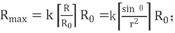
k is an adjusting coefficient, k is more than 0.5 and less than or equal to 1, and the k is set according to the ecological characteristics of the area where the point to be measured is located.
And 5, carrying out image shooting by using the unmanned aerial vehicle to spirally fly around the point to be measured at equal intervals, and recording the position coordinates.
And 6, sending the image data and the position data acquired by the unmanned aerial vehicle for processing, displaying and storing.
Preferably, the method further comprises a step 7 of resetting the flight altitude h, the shooting angle alpha and the adjusting coefficient k of the unmanned aerial vehicle according to the image data and the position data collected by the unmanned aerial vehicle, and repeating the steps 4-6 until the image data meeting the requirements are obtained.
Preferably, the determination of the point to be measured in step 1 specifically includes: (1) acquiring a remote sensing base map and an ecological protection red line map of a to-be-surveyed area; (2) and marking the ecological protection red line on the remote sensing base map, and judging the position coordinates of the points to be measured, which need to be surveyed.
Preferably, step 2 specifically comprises: (1) respectively taking a plurality of points on the ecological protection red lines at two sides of the point to be measured at equal intervals along the ecological protection red lines; (2) respectively performing linear fitting on the plurality of points on the two sides of the point to be measured by using a least square method; (3) calculating an included angle theta of the two straight lines obtained through fitting; (4) respectively calculating the correlation coefficient r fitting the two straight lines1And r2Total fitting correlation coefficient
Corresponding to the ecological protection red line area prospecting method, the invention provides an ecological protection red line area prospecting system, which comprises: the system comprises a local server, a data cloud platform, a mobile terminal and a mobile inspection terminal; the data cloud platform is connected with the local server, the mobile terminal and the mobile inspection terminal through a wireless communication network; the mobile inspection terminal comprises an unmanned aerial vehicle, and a positioning module and a camera module which are carried by the unmanned aerial vehicle, wherein the unmanned aerial vehicle comprises a communication device and a controller; the local server receives the remote sensing image base map, determines the position coordinates of points to be measured of the ecological protection red line by combining the ecological protection red line, and sends the ecological protection red line and the position coordinate information of the points to be measured to the data cloud platform; the mobile terminal sets the flight height h, the shooting angle alpha and the adjusting coefficient k of the unmanned aerial vehicle and sends the flight height h, the shooting angle alpha and the adjusting coefficient k to the data cloud platform; the data cloud platform generates unmanned aerial vehicle control information and sends the unmanned aerial vehicle control information to the controller; the controller is used for controlling the flight attitude and the flight track of the unmanned aerial vehicle according to the control information of the data cloud platform; the communication device is used for transmitting the position data acquired by the positioning module and the image data shot by the camera module to the data cloud platform; and the data cloud platform receives the position data and the image data and respectively sends the position data and the image data to a local server and a mobile terminal.
Preferably, the mobile terminal checks the received position data and image data, resets the flight height h, the shooting angle alpha and the adjusting coefficient k of the unmanned aerial vehicle and sends the flight height h, the shooting angle alpha and the adjusting coefficient k to the data cloud platform; and the data cloud platform controls the unmanned aerial vehicle to re-acquire related information.
Preferably, the surveying system further comprises a management platform and a background desktop end, and the local server is connected with the management platform and the background desktop end.
Preferably, the local server receives and stores remote sensing images of the area to be surveyed, which are shot by the satellite, and simultaneously, the local server stores the ecological protection red line graph of the area to be surveyed.
Preferably, the positioning module is a GPS locator or a beidou satellite locator, the camera module is a camera, and the camera is mounted on the lower side of the unmanned aerial vehicle through an aerial photography cradle head.
Preferably, the mobile terminal is a smart phone, a tablet computer or a notebook computer.
The unmanned aerial vehicle in the technical scheme can replace inspectors to arrive at a region with dangerous terrain to carry out the exploration work so as to improve the exploration efficiency. Considering that the natural protection area needs a large surveying area and a complex terrain and is often located in an area with weak communication signals, the unmanned aerial vehicle is required to have flexible and stable flight capability and be capable of conveniently supplying for endurance. Preferably, the mobile surveying terminal further comprises a plurality of unmanned aerial vehicle sky trees arranged in the area to be surveyed, and each unmanned aerial vehicle sky tree provides a logistics support integrating scheduling command, application monitoring, communication relay and endurance supply for the unmanned aerial vehicle in the area. When the unmanned aerial vehicle surveying system is used, an unmanned aerial vehicle sky tree is arranged at a proper position of an area needing surveying, the unmanned aerial vehicle is parked in the unmanned aerial vehicle sky tree, and after control information sent by a data cloud platform is received, a controller of the unmanned aerial vehicle flies to a point to be surveyed to survey; returning to the unmanned aerial vehicle sky tree for energy supplement when the unmanned aerial vehicle is insufficient in energy; and after the survey is finished, the unmanned aerial vehicle returns to the unmanned aerial vehicle sky tree to park, and waits for a next boundary surveying command.
Preferably, the sky tree of the unmanned aerial vehicle includes: the trunk extends to the high altitude from the bottom, and the interior of the trunk is of a hollow structure; the flight platform is arranged at the top end of the trunk and used for taking off and landing of the unmanned aerial vehicle; the elevator is arranged in the trunk and used for lifting the unmanned aerial vehicle between the bottom and the flying platform; the parking room is used for parking the unmanned aerial vehicle, and the command center adopts radio communication to control the flight of the unmanned aerial vehicle.
Preferably, the unmanned aerial vehicle sky tree further comprises a refueling station for charging or refueling the unmanned aerial vehicle to improve the endurance time of the unmanned aerial vehicle.
Preferably, the supply station comprises a wireless charging module, correspondingly, a wireless charging unit is arranged on the unmanned aerial vehicle, and the supply station charges the unmanned aerial vehicle in a wireless charging mode.
Preferably, the command center uses 2G, 3G, 4G mobile communication, GPS communication or radio communication with specific channels.
Preferably, unmanned vehicles sky tree wholly is the tower type, and the shut down room forms multilayer branch structure on locating the trunk, and the shut down room can be parked or stored many unmanned vehicles simultaneously.
Preferably, the tower-type sky tree formed by the trunk and the branches is a large-scale radio antenna and can be used as a communication relay system of the unmanned aerial vehicle, so that the instant communication between a communication module of the unmanned aerial vehicle in the exploration area and the data cloud platform is more stable and efficient.
Compared with the prior art, the ecological protection red line area prospecting system has the following beneficial effects:
1. the unmanned aerial vehicle can replace manpower to arrive at a region with dangerous terrain for carrying out the exploration work, the efficiency and the safety of the exploration can be improved, and the cost of the exploration is reduced.
2. The data cloud platform is used for realizing data processing and short-term storage, so that a surveying system is simplified, and data transmission is more stable and rapid.
3. Unmanned vehicles sky tree does unmanned vehicles provides parking, communication relay and energy supplement point, conveniently treats simultaneously that the border region of surveying carries out multiple spot survey or surveys a lot of to single border point of surveying.
4. Relevant parameters of the unmanned aerial vehicle for collecting image data are set by combining the characteristic of ecological protection red lines, and the exploration efficiency is improved.
5. Different surveying boundary parameters are set according to different situations of the point to be measured in the ecological protection red line area, and meanwhile, the surveying boundary parameters can be timely adjusted according to the real-time surveying boundary result, so that the surveying boundary efficiency is improved, and the ecological protection red line area surveying boundary can be rapidly and comprehensively completed.
Drawings
In order to more clearly illustrate the technical solutions of the embodiments of the present invention, the drawings that are required to be used in the embodiments will be briefly described below, it should be understood that the following drawings only illustrate some embodiments of the present invention and therefore should not be considered as limiting the scope, and it will be apparent to those skilled in the art that other relevant drawings can be obtained from the drawings without inventive effort.
FIG. 1 is a general framework diagram of the ecological protection redline area exploration system according to example 1.
FIG. 2 is a flow chart illustrating the world surveying method for the ecological protected red line area according to example 1.
Fig. 3 is a schematic structural diagram of the sky tree of the unmanned aerial vehicle according to embodiment 2.
The reference numbers in the figures illustrate:
1-a local server; 2-a data cloud platform; 3-moving the surveying end; 4-a mobile terminal; 5-a management platform; 6-background desktop end; 7-remote sensing satellite; 8-remote sensing image; 9-an antenna; 10-branch; 11-tree trunk; 12-a flying platform; 13-an elevator; 14-stopping the machine room; 15-a command center; 16-replenishment station.
Detailed Description
The technical solution in the embodiments of the present invention will be clearly and completely described below with reference to the drawings in the embodiments of the present invention. It should be understood that the specific embodiments described herein are merely illustrative of the invention and are not intended to limit the invention. All other embodiments, which can be derived by a person skilled in the art from the embodiments of the invention without inventive step, are within the scope of the invention.
Example 1:
referring to fig. 1, the present embodiment provides an ecological protection redline area prospecting system, which includes: the system comprises a local server 1, a data cloud platform 2, a mobile terminal 4 and a mobile inspection terminal 3; the data cloud platform 2 is connected with the local server 1, the mobile terminal 4 and the mobile inspection terminal 3 through a wireless communication network; the mobile inspection terminal 3 comprises an unmanned aerial vehicle, and a positioning module and a camera module which are carried by the unmanned aerial vehicle, wherein the unmanned aerial vehicle comprises a communication device and a controller; the surveying system further comprises a management platform 5 and a background desktop end 6, and the local server is connected with the management platform and the background desktop end.
Referring to fig. 2, the embodiment provides a world surveying method based on the ecological protection red line area surveying system, which includes the following steps:
step 1, determining a surveying point to be measured in an ecological protection red line area by a remote sensing base map and a demarcated ecological protection red line. The local server 1 receives and stores a remote sensing image 8 of an area to be surveyed, which is shot by a remote sensing satellite 7, and simultaneously, the local server stores an ecological protection red line graph of the area to be surveyed. The local server 1 sends the remote sensing image base map 8 and the ecological protection red line to the data cloud platform, the data cloud platform determines the position coordinates of points to be measured of the ecological protection red line, and sends the ecological protection red line map marked with the position coordinate information of the points to be measured to the local server 1 and the mobile terminal 4;
and 2, determining the flight height h of the unmanned aerial vehicle, the shooting view field angle alpha and the adjusting coefficient k according to the ecological environment characteristics of the region where the point to be measured is located. Setting the flight height h of the unmanned aerial vehicle, the shooting view field angle alpha and the adjusting coefficient k by combining the ecological environment characteristics of the area to be measured, such as desert, grassland, plain, hilly, forest, lake, marsh and the like, wherein the flight height of the unmanned aerial vehicle in the desert, grassland, plain, lake and other areas is flat, the flight height of the unmanned aerial vehicle in the area with wide view field is properly reduced (for example, 20m), the shooting view field angle is properly increased (for example, 90 degrees), and the adjusting coefficient can also be selected to be a larger value (for example, 1); naturally, the above parameters may also be appropriately adjusted in consideration of weather factors, for example, if visibility in rainy or foggy days is low, the flying height of the aircraft is reduced, the shooting view field angle is reduced, and a small adjustment coefficient is selected; the setting of the parameters is set by a person skilled in the art according to the experience of data acquisition, and is not described in detail herein. And setting the flight height h, the shooting angle alpha and the adjusting coefficient k of the unmanned aerial vehicle through the mobile terminal, and sending the flight height h, the shooting angle alpha and the adjusting coefficient k to the data cloud platform.
And 3, the data cloud platform 2 respectively performs linear fitting on the ecological protection red lines on the two sides of the point to be measured by using a least square method, and calculates the linear straightness theta and the total fitting correlation coefficient r of the two sides of the point to be measured. The method specifically comprises the following steps: (1) a plurality of points are respectively taken along the ecological protection red lines at equal intervals on the two sides of the point to be measured, in the embodiment, the points are arranged along the ecological protection red lines at the two sides of the point to be measured according to the intervals Taking the coordinates of 50 points; (2) respectively performing straight line fitting on the 50 points on the two sides of the point to be measured by using a least square method; (3) calculating an included angle theta of the two straight lines obtained through fitting; (4) respectively calculating the correlation coefficient r fitting the two straight lines1And r2Total fitting correlation coefficient
And 4, determining the flight radius of the unmanned aerial vehicle. And the data cloud platform 2 calculates the flight radius of the unmanned aerial vehicle according to a formula.
Order to
Wherein Shooting a radius for the unmanned aerial vehicle;
the minimum radius of equidistant spiral flight is Rmin=kR0;
The maximum radius of equidistant spiral flight is
k is an adjusting coefficient, k is more than 0.5 and less than or equal to 1, and the k is set according to the characteristics of the ecological environment of the area where the point to be measured is located. And the data cloud platform 2 generates unmanned aerial vehicle control information and sends the unmanned aerial vehicle control information to the controller.
And 5, carrying out image shooting by using the unmanned aerial vehicle to spirally fly around the point to be measured at equal intervals, and recording the position coordinates. The controller controls the flight attitude and the flight track of the unmanned aerial vehicle according to the control information of the data cloud platform; and enabling the unmanned aerial vehicle to fly to the point to be measured, and shooting images and recording position coordinates while spirally flying around the point to be measured at equal intervals. And transmitting the position data acquired by the positioning module and the image data shot by the camera module to the data cloud platform through the communication device.
And 6, the data cloud platform 2 processes the received position data and the received image data and then respectively sends the processed position data and the processed image data to the local server 1 and the mobile terminal 4.
Step 7, the mobile terminal 4 receives and displays the image data and the position data processed by the data cloud platform 2, an operator judges whether the obtained image data meets the requirements, and if the obtained image data meets the requirements, the local server 1 and/or the mobile terminal 4 stores the image data and the position data processed by the data cloud platform 2; and if the image data does not meet the requirements, resetting the flight height h, the shooting angle alpha and the adjusting coefficient k of the unmanned aerial vehicle, and controlling the unmanned aerial vehicle to acquire the image data and the position data again until the image data meeting the requirements is obtained. The determination of whether the acquired data meets the requirements is a routine determination that can be made by those skilled in the art, such as whether the image resolution is appropriate, whether the image is clear, and the like, and will not be described in detail herein.
As an example of an implementation manner, in this embodiment, the positioning module is a GPS locator or a beidou satellite locator. The camera module is a camera, and the camera is mounted on the lower side of the unmanned aerial vehicle through an aerial photography holder. The mobile terminal is a smart phone, a tablet computer or a notebook computer.
Example 2:
referring to fig. 3, the present embodiment provides a world surveying system for ecological protection of a red line area, which includes all the technical features described in embodiment 1. In addition, in this embodiment, the patrol system further includes an unmanned aerial vehicle sky tree, where the unmanned aerial vehicle sky tree includes an antenna 9, branches 10, and a trunk 11, and extends from the bottom to the high altitude, and the trunk is hollow; the flying platform 12 is arranged at the top end of the trunk 11 and used for taking off and landing of the unmanned aerial vehicle; the elevator 13 is arranged in the trunk 11 and used for lifting the unmanned aerial vehicle between the bottom and the flying platform 12; a parking room 14 for parking the unmanned aerial vehicle, and a command center 15 for controlling the flight of the unmanned aerial vehicle by using radio communication. The command center 15 uses 2G, 3G, 4G mobile communication, GPS communication or radio communication with specific channels.
The UAV sky tree further includes a replenishment station 16 for charging or refueling the UAV to increase the endurance of the UAV. The supply station 16 comprises a wireless charging module, correspondingly, a wireless charging unit is arranged on the unmanned aerial vehicle, and the supply station charges the unmanned aerial vehicle in a wireless charging mode.
Unmanned vehicles sky tree wholly is the tower type, and branch 10 is column or platelike, stop computer lab 14 and locate the trunk 11 through branch 10 on, form multilayer structure together with branch 10, stop computer lab 14 and can park or store many unmanned vehicles simultaneously.
Preferably, the tower-type sky tree formed by the trunk 11 and the branches 10 is a large-scale radio antenna, and can be used as a communication relay system of the unmanned aerial vehicle, so that the instant communication between the communication module of the unmanned aerial vehicle in the exploration area and the data cloud platform is more stable and efficient.
When the unmanned aerial vehicle surveying system is used, an unmanned aerial vehicle sky tree is arranged at a proper position of a region needing surveying, a plurality of unmanned aerial vehicles are parked in the unmanned aerial vehicle sky tree, after control information sent by a data cloud platform is received, a controller of the unmanned aerial vehicle flies to a boundary point to be surveyed to survey, and collected information is sent to the data cloud platform through the unmanned aerial vehicle sky tree; returning to the unmanned aerial vehicle sky tree for energy supplement when the unmanned aerial vehicle is insufficient in energy; and after the survey is finished, the unmanned aerial vehicle returns to the unmanned aerial vehicle sky tree to park, and waits for a next boundary surveying command.
In embodiment 1, unmanned vehicles through from communication device who takes with data cloud platform communicates, and data transmission rate is lower, and because ecological protection red line area is treated the investigation border area and often the signal is relatively poor, signal transmission exists and postpones the condition that can't appear communicating even, can't realize unmanned vehicles ' real time control and real-time acquisition information and look over. In this embodiment, unmanned vehicles sky tree is as unmanned vehicles's communication relay, can improve unmanned vehicles with the stability of data cloud platform communication realizes looking over in real time of reconnaissance image and unmanned vehicles' real time control.
The above description is only an embodiment of the present invention, but the scope of the present invention is not limited thereto, and any person skilled in the art can easily conceive of changes or substitutions within the technical scope of the present invention, and the present invention should be covered by the scope of the present invention.
Claims (10)
1. A border exploration method for an ecological protection red line area comprises the following steps:
step 1, determining an ecological protection red line surveying boundary point to be measured according to a remote sensing base map and a demarcated ecological protection red line;
step 2, determining the flight height h of the unmanned aerial vehicle and a shooting view field angle alpha according to the ecological characteristics of the region where the point to be measured is located;
step 3, performing linear fitting on the ecological protection red lines on the two sides of the point to be measured by using a least square method respectively, and calculating the linearity theta and the total fitting correlation coefficient r of the two linear lines at the point to be measured;
step 4, determining the flight radius of the unmanned aerial vehicle;

wherein Shooting a radius for the unmanned aerial vehicle;
the minimum radius of equidistant spiral flight is Rmin-kR 0;
the maximum radius of equidistant spiral flight is

k is an adjustment coefficient, k is more than 0.5 and less than or equal to 1, and is set according to the ecological characteristics of the area where the point to be measured is located;
step 5, carrying out image shooting by using the unmanned aerial vehicle to fly spirally around the point to be measured at equal intervals, and recording position coordinates;
and 6, processing the image data and the position data acquired by the unmanned aerial vehicle.
2. The ecological protection redline area prospecting method of claim 1, further comprising step 7, resetting the flying height h, the shooting angle α, and the adjustment coefficient k of the unmanned aerial vehicle according to the image data and the position data collected by the unmanned aerial vehicle, and repeating steps 4-6 until satisfactory image data is obtained.
3. The ecological protection red line area prospecting method according to claim 1, wherein the determination of the point to be tested in step 1 specifically comprises: (1) acquiring a remote sensing base map and an ecological protection red line map of a to-be-surveyed area; (2) and marking the ecological protection red line on the remote sensing base map, and judging the position coordinates of the points to be measured, which need to be surveyed.
4. The ecological protection redline area prospecting method of claim 1, wherein step 2 specifically comprises: (1) respectively taking a plurality of points on the ecological protection red lines at two sides of the point to be measured at equal intervals along the ecological protection red lines; (2) respectively performing linear fitting on the plurality of points on the two sides of the point to be measured by using a least square method; (3) calculating an included angle theta of the two straight lines obtained through fitting; (4) calculating correlation coefficients r1 and r2 fitting the two straight lines respectively, and calculating a total fitting correlation coefficient
5. A world surveying system based on the ecological protection redline area surveying method of any one of claims 1 to 4, the world surveying system comprising: the system comprises a local server, a data cloud platform, a mobile terminal and a mobile inspection terminal; the data cloud platform is connected with the local server, the mobile terminal and the mobile inspection terminal through a wireless communication network; the mobile inspection terminal comprises an unmanned aerial vehicle, and a positioning module and a camera module which are carried by the unmanned aerial vehicle, wherein the unmanned aerial vehicle comprises a communication device and a controller; the local server receives the remote sensing image base map, determines the position coordinates of points to be measured of the ecological protection red line by combining the ecological protection red line, and sends the ecological protection red line and the position coordinate information of the points to be measured to the data cloud platform; the mobile terminal sets the flight height h, the shooting angle alpha and the adjusting coefficient k of the unmanned aerial vehicle and sends the flight height h, the shooting angle alpha and the adjusting coefficient k to the data cloud platform; the data cloud platform generates unmanned aerial vehicle control information and sends the unmanned aerial vehicle control information to the controller; the controller is used for controlling the flight attitude and the flight track of the unmanned aerial vehicle according to the control information of the data cloud platform; the communication device is used for transmitting the position data acquired by the positioning module and the image data shot by the camera module to the data cloud platform; and the data cloud platform receives the position data and the image data and respectively sends the position data and the image data to a local server and a mobile terminal.
6. The surveying system of claim 5, wherein the mobile terminal views the received position data and image data, resets a flying height h, a shooting angle α, and an adjustment coefficient k of the unmanned aerial vehicle, and sends the flying height h, the shooting angle α, and the adjustment coefficient k to the data cloud platform; and the data cloud platform controls the unmanned aerial vehicle to re-acquire related information.
7. The system of claim 5, further comprising a management platform and a back-office desktop, wherein the local server is connected to the management platform and the back-office desktop.
8. The ecological protection red line region surveying system of claim 5, wherein the local server receives and stores remote sensing images of the area to be surveyed taken by the satellite, and simultaneously, the local server stores the ecological protection red line map of the area to be surveyed.
9. The ecological protection red line area prospecting system of claim 5, wherein the positioning module is a GPS (global positioning system) locator or a Beidou satellite locator, the camera module is a camera, and the camera is carried on the lower side of the unmanned aerial vehicle through an aerial photography holder.
10. The ecological protection red line area prospecting system of claim 5, wherein the mobile terminal is a smart phone, a tablet computer or a notebook computer.
Priority Applications (1)
| Application Number | Priority Date | Filing Date | Title |
|---|---|---|---|
| CN201810941598.2A CN108983820B (en) | 2018-08-17 | 2018-08-17 | Ecological protection red line area boundary exploration method and system |
Applications Claiming Priority (1)
| Application Number | Priority Date | Filing Date | Title |
|---|---|---|---|
| CN201810941598.2A CN108983820B (en) | 2018-08-17 | 2018-08-17 | Ecological protection red line area boundary exploration method and system |
Publications (2)
| Publication Number | Publication Date |
|---|---|
| CN108983820A CN108983820A (en) | 2018-12-11 |
| CN108983820B true CN108983820B (en) | 2021-04-16 |
Family
ID=64554044
Family Applications (1)
| Application Number | Title | Priority Date | Filing Date |
|---|---|---|---|
| CN201810941598.2A Active CN108983820B (en) | 2018-08-17 | 2018-08-17 | Ecological protection red line area boundary exploration method and system |
Country Status (1)
| Country | Link |
|---|---|
| CN (1) | CN108983820B (en) |
Families Citing this family (1)
| Publication number | Priority date | Publication date | Assignee | Title |
|---|---|---|---|---|
| CN113923242B (en) * | 2021-09-30 | 2023-08-29 | 伟志股份公司 | GIS-based natural disaster risk investigation system and method |
Citations (13)
| Publication number | Priority date | Publication date | Assignee | Title |
|---|---|---|---|---|
| CN102495522A (en) * | 2011-12-01 | 2012-06-13 | 天津曙光敬业科技有限公司 | Method for manufacturing 360-degree air panoramic interactive roam system based on unmanned helicopter aerial shooting |
| CN104182754A (en) * | 2014-08-19 | 2014-12-03 | 山东临沂烟草有限公司 | Rural resident point information extraction method based on high-resolution remote-sensing image |
| WO2015005573A1 (en) * | 2013-07-09 | 2015-01-15 | 주식회사 두레텍 | Method for constructing air-observed terrain data by using rotary wing structure |
| CN104704424A (en) * | 2012-08-21 | 2015-06-10 | 视觉智能有限合伙公司 | Infrastructure mapping system and method |
| CN104714557A (en) * | 2015-03-26 | 2015-06-17 | 清华大学 | Method for controlling fixed point circular flying of unmanned plane |
| CN105388905A (en) * | 2015-10-30 | 2016-03-09 | 深圳一电航空技术有限公司 | Unmanned aerial vehicle flight control method and device |
| CN205691120U (en) * | 2016-06-23 | 2016-11-16 | 洛阳理工学院 | A kind of topography mapping device of UAV flight's total powerstation |
| CN106657779A (en) * | 2016-12-13 | 2017-05-10 | 重庆零度智控智能科技有限公司 | Surround shooting method and device, and unmanned aerial vehicle |
| CN107305374A (en) * | 2016-04-22 | 2017-10-31 | 优利科技有限公司 | Unmanned aerial vehicle system of taking photo by plane |
| CN107544548A (en) * | 2017-10-20 | 2018-01-05 | 广州极飞科技有限公司 | Control the method, apparatus and unmanned plane of unmanned machine operation |
| CN108020212A (en) * | 2017-12-06 | 2018-05-11 | 长江三峡勘测研究院有限公司(武汉) | A kind of small scale mapping method based on unmanned plane Yu CORS technologies |
| CN207601628U (en) * | 2017-12-29 | 2018-07-10 | 四川师范大学 | Move inspection system in a kind of ecological protection red line area |
| CN108366118A (en) * | 2018-02-11 | 2018-08-03 | 苏州光之翼智能科技有限公司 | A kind of real-time mapping system of distributed unmanned plane based on cloud computing |
-
2018
- 2018-08-17 CN CN201810941598.2A patent/CN108983820B/en active Active
Patent Citations (13)
| Publication number | Priority date | Publication date | Assignee | Title |
|---|---|---|---|---|
| CN102495522A (en) * | 2011-12-01 | 2012-06-13 | 天津曙光敬业科技有限公司 | Method for manufacturing 360-degree air panoramic interactive roam system based on unmanned helicopter aerial shooting |
| CN104704424A (en) * | 2012-08-21 | 2015-06-10 | 视觉智能有限合伙公司 | Infrastructure mapping system and method |
| WO2015005573A1 (en) * | 2013-07-09 | 2015-01-15 | 주식회사 두레텍 | Method for constructing air-observed terrain data by using rotary wing structure |
| CN104182754A (en) * | 2014-08-19 | 2014-12-03 | 山东临沂烟草有限公司 | Rural resident point information extraction method based on high-resolution remote-sensing image |
| CN104714557A (en) * | 2015-03-26 | 2015-06-17 | 清华大学 | Method for controlling fixed point circular flying of unmanned plane |
| CN105388905A (en) * | 2015-10-30 | 2016-03-09 | 深圳一电航空技术有限公司 | Unmanned aerial vehicle flight control method and device |
| CN107305374A (en) * | 2016-04-22 | 2017-10-31 | 优利科技有限公司 | Unmanned aerial vehicle system of taking photo by plane |
| CN205691120U (en) * | 2016-06-23 | 2016-11-16 | 洛阳理工学院 | A kind of topography mapping device of UAV flight's total powerstation |
| CN106657779A (en) * | 2016-12-13 | 2017-05-10 | 重庆零度智控智能科技有限公司 | Surround shooting method and device, and unmanned aerial vehicle |
| CN107544548A (en) * | 2017-10-20 | 2018-01-05 | 广州极飞科技有限公司 | Control the method, apparatus and unmanned plane of unmanned machine operation |
| CN108020212A (en) * | 2017-12-06 | 2018-05-11 | 长江三峡勘测研究院有限公司(武汉) | A kind of small scale mapping method based on unmanned plane Yu CORS technologies |
| CN207601628U (en) * | 2017-12-29 | 2018-07-10 | 四川师范大学 | Move inspection system in a kind of ecological protection red line area |
| CN108366118A (en) * | 2018-02-11 | 2018-08-03 | 苏州光之翼智能科技有限公司 | A kind of real-time mapping system of distributed unmanned plane based on cloud computing |
Also Published As
| Publication number | Publication date |
|---|---|
| CN108983820A (en) | 2018-12-11 |
Similar Documents
| Publication | Publication Date | Title |
|---|---|---|
| US20230186776A1 (en) | Unmanned aerial vehicle management | |
| US12449409B2 (en) | Emissions estimate model algorithms and methods | |
| US11216015B2 (en) | Geographic survey system for vertical take-off and landing (VTOL) unmanned aerial vehicles (UAVs) | |
| US10962655B2 (en) | Systems and methods for positioning of UAV | |
| Samad et al. | The potential of Unmanned Aerial Vehicle (UAV) for civilian and mapping application | |
| CN112326686A (en) | Unmanned aerial vehicle intelligent cruise pavement disease detection method, unmanned aerial vehicle and detection system | |
| CN103852077B (en) | Automatic anti-cheating judgment method for unmanned aerial vehicle positioning information in link failure process | |
| US20170225799A1 (en) | Composition and process for applying hydrophobic coating to fibrous substrates | |
| CN109783593A (en) | A kind of map updating system can be used for automatic Pilot and method | |
| CN106371452B (en) | Method, device and system for acquiring and sharing flight-limiting area information of aircraft | |
| WO2016130711A1 (en) | Pod operating system for a vertical take-off and landing (vtol) unmanned aerial vehicle (uav) | |
| CN108303995A (en) | A substation inspection UAV flight safety system | |
| CN110647170B (en) | Unmanned aerial vehicle-based navigation mark inspection device and method | |
| CN106249752A (en) | A kind of unmanned plane networking flight monitoring and collaborative collision avoidance method and device | |
| CN116299450B (en) | All-weather ocean search and rescue system and method based on rainbow unmanned aerial vehicle multi-source remote sensing | |
| Petrides et al. | Disaster prevention and emergency response using unmanned aerial systems | |
| CN110720198A (en) | System and method for electronic fence | |
| CN107741233A (en) | A kind of construction method of the outdoor map of three-dimensional | |
| CN206291896U (en) | A kind of three-dimensional mapping system | |
| Chaudhry et al. | A comparative study of modern UAV platform for topographic mapping | |
| CN111526478B (en) | Mountain scenic spot complex terrain unmanned aerial vehicle collaborative search and rescue system and device thereof | |
| CN108983820B (en) | Ecological protection red line area boundary exploration method and system | |
| CN113063401A (en) | Unmanned aerial vehicle aerial survey system | |
| CN116817892A (en) | Cloud integrated unmanned aerial vehicle route positioning method and system based on visual semantic map | |
| CN112286219A (en) | Surveying and mapping system and surveying and mapping method for outdoor geographic surveying and mapping |
Legal Events
| Date | Code | Title | Description |
|---|---|---|---|
| PB01 | Publication | ||
| PB01 | Publication | ||
| SE01 | Entry into force of request for substantive examination | ||
| SE01 | Entry into force of request for substantive examination | ||
| GR01 | Patent grant | ||
| GR01 | Patent grant |