CN108806257B - Method for identifying congested areas and congested road sections - Google Patents
Method for identifying congested areas and congested road sections Download PDFInfo
- Publication number
- CN108806257B CN108806257B CN201810724855.7A CN201810724855A CN108806257B CN 108806257 B CN108806257 B CN 108806257B CN 201810724855 A CN201810724855 A CN 201810724855A CN 108806257 B CN108806257 B CN 108806257B
- Authority
- CN
- China
- Prior art keywords
- road
- congested
- section
- congestion
- area
- Prior art date
- Legal status (The legal status is an assumption and is not a legal conclusion. Google has not performed a legal analysis and makes no representation as to the accuracy of the status listed.)
- Expired - Fee Related
Links
Classifications
-
- G—PHYSICS
- G08—SIGNALLING
- G08G—TRAFFIC CONTROL SYSTEMS
- G08G1/00—Traffic control systems for road vehicles
- G08G1/01—Detecting movement of traffic to be counted or controlled
- G08G1/0104—Measuring and analyzing of parameters relative to traffic conditions
- G08G1/0125—Traffic data processing
- G08G1/0133—Traffic data processing for classifying traffic situation
Landscapes
- Chemical & Material Sciences (AREA)
- Analytical Chemistry (AREA)
- Physics & Mathematics (AREA)
- General Physics & Mathematics (AREA)
- Traffic Control Systems (AREA)
Abstract
本发明公开了一种道路拥堵区域和拥堵路段的识别方法,其特征在于:包括步骤:一、获取并判断车辆的GPS数据的可用性;二、根据道路交叉口区域内车辆的数量变化识别道路拥堵区域,如果两个拥堵区域由一个路段直接连接,则这两个拥堵区域是相邻的,将相邻的拥堵区域合并,得到合并拥堵区域;三、按地标、范围的形式生成合并拥堵区域的位置和范围;四、分析道路中拥堵路段的分布特征,将拥堵路段按所属道路进行分类,并按编号从小到大进行排序,确定编号分类结果;五、根据拥堵路段编号分类结果识别路段拥堵情况。本发明解决了较大区域范围内的拥堵识别问题,采取两层分类的方法来确保结果的准确性。The invention discloses a method for identifying road congested areas and congested road sections, which is characterized by comprising the steps of: 1. obtaining and judging the availability of GPS data of vehicles; 2. identifying road congestion according to changes in the number of vehicles in a road intersection area If two congested areas are directly connected by a road section, the two congested areas are adjacent, and the adjacent congested areas are merged to obtain a combined congested area; 3. Generate a combined congested area in the form of landmarks and ranges. Location and scope; 4. Analyze the distribution characteristics of the congested sections in the road, classify the congested sections according to the road they belong to, and sort them according to the number from small to large, and determine the classification result of the number; 5. Identify the congestion of the road section according to the classification result of the number of the congested section . The invention solves the problem of congestion identification in a larger area, and adopts a two-layer classification method to ensure the accuracy of the results.
Description
技术领域technical field
本发明涉及智能交通技术领域,具体涉及一种道路拥堵区域和拥堵路段的识别方法。The invention relates to the technical field of intelligent transportation, in particular to a method for identifying a road congestion area and a congested road section.
背景技术Background technique
现今,中国已进入汽车普及时代,而交通拥堵是各大城市普遍面临的难题。如何及时准确地进行城市范围内拥堵区域的识别成为一个亟待解决的问题。现有的识别方法主要是交通控制中心或城市交通广播中的播报人员根据实时的城市路网图显示的零散路段路况,凭经验组合路况,识别出拥堵区域。这种方法不仅需要一定的人力,而且准确性受播报人员的经验、标准偏好影响较大,主观性较强。为了能够更加有效地缓解城市拥堵、帮助交警制定策略,提出一种可以客观识别城市拥堵的方法具有重要意义。Today, China has entered the era of popularization of automobiles, and traffic congestion is a common problem faced by major cities. How to timely and accurately identify the congested area within the city has become an urgent problem to be solved. The existing identification methods are mainly based on the traffic control center or the broadcaster in the urban traffic broadcast, based on the scattered road conditions displayed by the real-time urban road network map, and combining the road conditions based on experience to identify the congested areas. This method not only requires a certain amount of manpower, but also the accuracy is greatly affected by the broadcaster's experience and standard preference, and the subjectivity is strong. In order to alleviate urban congestion more effectively and help traffic police formulate strategies, it is of great significance to propose a method that can objectively identify urban congestion.
发明内容SUMMARY OF THE INVENTION
为解决现有技术中的不足,本发明提供一种道路拥堵区域和拥堵路段的识别方法,解决了现有方法中识别拥堵区域的主观性较强、浪费人力的问题。In order to solve the deficiencies in the prior art, the present invention provides a method for identifying road congested areas and congested road sections, which solves the problems of high subjectivity and waste of manpower in identifying congested areas in the existing method.
为了实现上述目标,本发明采用如下技术方案:一种道路拥堵区域和拥堵路段的识别方法,其特征在于:包括步骤:In order to achieve the above-mentioned goals, the present invention adopts the following technical solutions: a method for identifying road congestion areas and congestion road sections, which is characterized in that: it includes the steps:
一、获取并判断车辆的GPS数据的可用性;1. Obtain and judge the availability of GPS data of the vehicle;
二、根据道路交叉口区域内车辆的数量变化识别道路拥堵区域,如果两个拥堵区域由一个路段直接连接,则这两个拥堵区域是相邻的,将相邻的拥堵区域合并,得到合并拥堵区域;2. Identify road congested areas according to the changes in the number of vehicles in the road intersection area. If two congested areas are directly connected by a road section, then the two congested areas are adjacent, and the adjacent congested areas are merged to obtain the combined congestion area. area;
三、按地标、范围的形式生成合并拥堵区域的位置和范围;3. Generate the location and range of the merged congested area in the form of landmarks and ranges;
四、分析道路中拥堵路段的分布特征,将拥堵路段按所属道路进行分类,并按编号从小到大进行排序,确定编号分类结果;4. Analyze the distribution characteristics of the congested road sections in the road, classify the congested road sections according to the road to which they belong, and sort them according to the number from small to large, and determine the result of the number classification;
五、根据拥堵路段编号分类结果识别路段拥堵情况。5. Identify the congestion situation of the road section according to the classification result of the number of the congested road section.
前述的一种道路拥堵区域和拥堵路段的识别方法,其特征是:所述步骤一获取并判断车辆的GPS数据的可用性,具体为:The aforementioned method for identifying a road congestion area and a congested road section is characterized in that: the step 1 obtains and judges the availability of the GPS data of the vehicle, specifically:
获取车辆GPS数据,车辆GPS数据包括GPS设备的用户ID、车辆所在位置的经纬度和传送数据的时间戳,根据车辆GPS数据的经纬度是否在要进行识别的道路交叉口区域内确定车辆GPS数据的可用性。Obtain vehicle GPS data, the vehicle GPS data includes the user ID of the GPS device, the latitude and longitude of the location of the vehicle, and the time stamp of the transmitted data, and determine the availability of the vehicle GPS data according to whether the latitude and longitude of the vehicle GPS data is within the road intersection area to be identified. .
前述的一种道路拥堵区域和拥堵路段的识别方法,其特征是:所述步骤二,具体为:The aforementioned method for identifying a road congestion area and a congested road section is characterized in that: the second step is specifically:
假设道路交叉口中心坐标为(r,s),设A’=(r-c,r+c,s-c,s+c)为道路交叉口区域,其中c为常数,T时刻时在交叉口区域内的车辆组成可用车辆GPS数据集P={p(x,y)|p∈A’},nT为T时刻车辆子群P的可用车辆GPS数据个数,nT+t为T+t时刻车辆子群P的可用车辆GPS数据个数,可用车辆GPS数据减少量: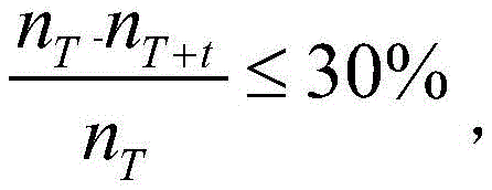
前述的一种道路拥堵区域和拥堵路段的识别方法,其特征是:所述步骤三按地标、范围的形式生成合并拥堵区域的位置和范围,具体为:The aforementioned method for identifying road congested areas and congested road sections is characterized in that: the step 3 generates the location and range of the merged congested area in the form of landmarks and ranges, specifically:
合并拥堵区域按“地标+范围”的形式进行标识,分别计算合并拥堵区域内包含的m个交叉口中心点的横坐标平均值

以

前述的一种道路拥堵区域和拥堵路段的识别方法,其特征是:所述步骤四,具体步骤包括:The aforementioned method for identifying a road congestion area and a congested road section is characterized in that: in the step 4, the specific steps include:
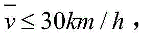
1)根据车流速度确定路段是否拥堵,若路段内车速平均值
2)道路的路段按从北往南、从西往东的顺序从小到大依次编号,编号值为路段属性之一,若道路一共有N个路段,编号值为1,2,…,N;2) The sections of the road are numbered from small to large in the order from north to south and from west to east, and the number value is one of the attributes of the road section. If the road has a total of N sections, the number value is 1, 2, ..., N;
3)道路的拥堵情况由三种基本情况组成:ⅰ北或西段拥堵,ⅱ中段拥堵,ⅲ南或东段拥堵;3) The road congestion situation consists of three basic situations: ⅰ north or west section congestion, ⅱ middle section congestion, ⅲ south or east section congestion;
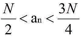
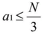
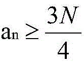
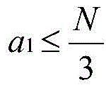
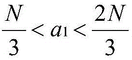
4)道路拥堵路段的编号关系存在两种可能:1.编号连续,a1,a2,…,an,其中an=a1+n-1,{an}是首项为a1,公差为1的等差数列;2.编号间断,a1,b,其中b≠a1+1;4) There are two possibilities for the numbering relationship of road congested sections: 1. The numbering is continuous, a 1 , a2, ..., an , where a n = a 1 + n -1, {a n } is the first item a 1 , Arithmetic sequence with tolerance 1; 2. Numbering discontinuity, a 1 , b, where b≠a 1 +1;
{an},b都是道路拥堵路段的编号,a1<b。{a n }, b are the numbers of the congested sections of the road, a 1 <b.
5)根据道路拥堵路段的编号特征进行分类:5) Classify according to the numbering characteristics of road congestion sections:
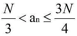
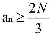
编号连续时连续路段分成六种情况:When the numbers are consecutive, the consecutive road sections are divided into six situations:
1.

2.
3.
4.

5.

6.

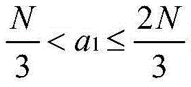
编号间断时单个路段分为三种情况:When the numbering is interrupted, a single road segment is divided into three situations:
1.
2.
3.
前述的一种道路拥堵区域和拥堵路段的识别方法,其特征是:所述步骤五,根据拥堵路段编号分类结果识别路段拥堵情况,具体为:The aforementioned method for identifying a road congestion area and a congested road section is characterized in that: in the step 5, the congestion situation of the road section is identified according to the result of the number and classification of the congested road section, specifically:
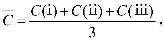
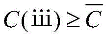
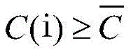
拥堵路段编号可能包含连续和间断两种情况,将连续路段部分根据编号连续情况进行分类,单个路段部分根据编号间断情况进行分类,所有部分的编号分类结果包括并可拆分成ⅰⅱⅲ三种基本的道路拥堵情况,ⅰⅱⅲ三种基本情况出现的次数分别为C(ⅰ),C(ⅱ),C(ⅲ),三种基本情况出现的平均次数
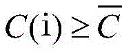
1)任一种基本情况出现次数不为0:


2)存在一种基本情况出现次数为0:若C(ⅰ)=0时,该道路中段和南(东)段拥堵;C(ⅱ)=0时,该道路北(西)段和南(东)段拥堵;C(ⅲ)=0时,该道路北(西)段和中段拥堵。2) There is a basic situation where the number of occurrences is 0: if C(i)=0, the middle and south (east) sections of the road are congested; when C(ii)=0, the north (west) and south ( The east) section is congested; when C(iii)=0, the north (west) section and the middle section of the road are congested.
3)存在两种基本情况出现次数为0:C(ⅰ)=0且C(ⅱ)=0时,该道路南(东)段拥堵;C(ⅰ)=0且C(ⅲ)=0时,该道路中段拥堵;C(ⅱ)=0且C(ⅲ)=0时,该道路北(西)段拥堵。3) There are two basic situations where the number of occurrences is 0: when C(i)=0 and C(ii)=0, the south (east) section of the road is congested; when C(i)=0 and C(iii)=0 , the middle section of the road is congested; when C(ii)=0 and C(iii)=0, the north (west) section of the road is congested.
本发明所达到的有益效果:本发明利用计算机客观的进行城市拥堵识别,减少因拥堵而产生的经济损失;利用交叉口区域的可用车辆GPS数据减少量程度来确定拥堵区域,拥堵区域的合并有效的解决了较大区域范围内的拥堵识别问题,同时也减少拥堵信息的条数;为了避免计算机产生识别误差,采取两层分类的方法来确保结果的准确性;首先将道路的拥堵路段根据编号分为连续和间断两种情况,再根据连续和间断的具体情况进行具体分类,得到编号分类结果;编号分类结果由基本拥堵情况组成,根据各种基本拥堵情况的出现频率再一次进行分类。Beneficial effects achieved by the present invention: the present invention utilizes the computer to objectively identify the urban congestion, and reduces the economic loss caused by the congestion; utilizes the degree of reduction of available vehicle GPS data in the intersection area to determine the congested area, and the merging of the congested area is effective It solves the problem of congestion identification in a large area, and also reduces the number of pieces of congestion information; in order to avoid computer identification errors, a two-layer classification method is adopted to ensure the accuracy of the results; It is divided into two cases: continuous and discontinuous, and then the specific classification is carried out according to the specific conditions of continuous and discontinuous, and the numbered classification result is obtained; the numbered classification result is composed of basic congestion conditions, and is classified again according to the frequency of occurrence of various basic congestion conditions.
具体实施方式Detailed ways
下面对本发明作进一步描述。以下实施例仅用于更加清楚地说明本发明的技术方案,而不能以此来限制本发明的保护范围。The present invention is further described below. The following examples are only used to illustrate the technical solutions of the present invention more clearly, and cannot be used to limit the protection scope of the present invention.
一种道路拥堵区域和拥堵路段的识别方法,包括步骤:A method for identifying road congested areas and congested road sections, comprising the steps of:
步骤一,获取并判断车辆的GPS数据的可用性;Step 1, obtaining and judging the availability of GPS data of the vehicle;
获取车辆GPS数据,车辆GPS数据包括GPS设备的用户ID、车辆所在位置的经纬度和传送数据的时间戳,根据GPS数据的经纬度是否在目标区域内确定车辆GPS数据的可用性;Obtaining vehicle GPS data, the vehicle GPS data includes the user ID of the GPS device, the latitude and longitude of the location of the vehicle, and the time stamp of the transmitted data, and the availability of the vehicle GPS data is determined according to whether the latitude and longitude of the GPS data is within the target area;
目标区域是要进行识别的道路交叉口区域;The target area is the road intersection area to be identified;
通过GPS设备获取的数据格式如下:The data format obtained by the GPS device is as follows:
对原始车辆GPS数据进行筛选,去掉不属于目标区域范围的车辆GPS数据,确保对交通拥堵区域识别的准确性。目标区域记为A=(xmin,xmax,ymin,ymax),其中,xmin为目标区域的最小经度值,xmax为目标区域的最大经度值,ymin为目标区域的最小纬度值,ymax为目标区域的最大纬度值。The original vehicle GPS data is screened, and the vehicle GPS data that does not belong to the target area is removed to ensure the accuracy of the identification of the traffic congestion area. The target area is denoted as A=(x min , x max , y min , y max ), where x min is the minimum longitude value of the target area, x max is the maximum longitude value of the target area, and y min is the minimum latitude value of the target area value, y max is the maximum latitude value of the target area.
车辆GPS数据p(x,y),x为经度,y为纬度,满足条件:xmin≤x≤xmax且ymin≤y≤ymax,则该车辆GPS数据是可用的,可用车辆GPS数据集为P={p(x,y)|p∈A}。Vehicle GPS data p(x,y), x is longitude, y is latitude, and the conditions are met: x min ≤x≤x max and y min ≤y≤y max , then the vehicle GPS data is available, and the available vehicle GPS data The set is P={p(x,y)|p∈A}.
步骤二,根据道路交叉口区域内车辆的数量变化识别道路拥堵区域,如果两个拥堵区域由一个路段直接连接,则这两个拥堵区域是相邻的,将相邻的拥堵区域合并,得到合并拥堵区域;Step 2: Identify road congested areas according to the changes in the number of vehicles in the road intersection area. If two congested areas are directly connected by a road section, the two congested areas are adjacent, and the adjacent congested areas are merged to obtain a merged congested areas;
假设道路交叉口中心坐标为(r,s),设A’=(r-c,r+c,s-c,s+c)为道路交叉口区域,其中c为常数,T时刻时在交叉口区域内的车辆组成可用车辆GPS数据集(即车辆子群)P={p(x,y)|p∈A’},nT为T时刻车辆子群P的可用车辆GPS数据个数,nT+t为T+t时刻车辆子群P的可用车辆GPS数据个数,可用车辆GPS数据减少量: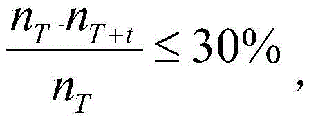
步骤三,按地标、范围的形式生成合并拥堵区域的位置和范围;Step 3: Generate the location and range of the merged congestion area in the form of landmarks and ranges;
合并拥堵区域按“地标+范围”的形式进行标识,分别计算合并拥堵区域内包含的m个交叉口中心点的横坐标平均值

以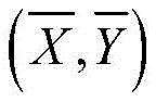

步骤四,分析道路中拥堵路段的分布特征,将拥堵路段按所属道路进行分类,并按编号从小到大进行排序,确定编号分类结果;具体包括步骤:Step 4: Analyze the distribution characteristics of the congested road sections in the road, classify the congested road sections according to the road to which they belong, and sort them according to the number from small to large, and determine the result of the number classification; the specific steps include:
1、确定拥堵路段,根据车流速度确定路段是否拥堵,若路段内车速平均值
2、道路的路段按从北往南、从西往东的顺序从小到大依次编号,编号值为路段属性之一,若道路一共有N个路段,编号值为1,2,…,N;例如,中央大街为东西向道路,有五个路段,从西往东依次编号为1,2,3,4,5;2. The sections of the road are numbered from small to large in the order from north to south and from west to east. The number value is one of the attributes of the road section. If the road has a total of N sections, the number value is 1, 2, ..., N; For example, Central Street is an east-west road with five sections, numbered 1, 2, 3, 4, and 5 from west to east;
3、道路的拥堵情况由三种基本情况组成:ⅰ北(西)段拥堵,ⅱ中段拥堵,ⅲ南(东)段拥堵;3. The road congestion situation consists of three basic situations: ⅰ North (West) section congestion, ⅱ Middle section congestion, ⅲ South (East) section congestion;
4、将拥堵路段按所属道路进行分类,并按编号从小到大进行排序;道路拥堵路段的编号关系存在两种可能:1.编号连续,a1,a2,…,an,其中an=a1+n-1,{an}是首项为a1,公差为1的等差数列;2.编号间断,a1,b,其中b≠a1+1。4. Classify the congested road sections according to the road they belong to, and sort them according to the number from small to large; there are two possibilities for the numbering relationship of the road congested road sections: 1. The numbering is continuous, a 1 , a 2 ,…, a n , where a n =a 1 +n-1,{a n } is an arithmetic sequence with the leading term a 1 and a tolerance of 1; 2. Numbering discontinuity, a 1 ,b, where b≠a 1 +1.
{an},b都是道路拥堵路段的编号,a1<b;{a n }, b is the number of the road congested section, a 1 <b;
5、根据道路拥堵路段的编号特征进行分类:5. Classify according to the numbering characteristics of road congestion sections:
编号连续时连续路段分成六种情况:When the numbers are consecutive, the consecutive road sections are divided into six situations:
1.

2.

3.

4.

5.

6.

编号间断时单个路段分为三种情况:When the numbering is interrupted, a single road segment is divided into three situations:
1.
2.
3.
步骤五,根据拥堵路段编号分类结果识别路段拥堵分布情况;Step 5: Identify the congestion distribution of the road section according to the classification result of the number of the congested road section;
识别路段拥堵分布情况具体包括:拥堵路段编号可能包含连续和间断两种情况,将连续路段部分根据编号连续情况进行分类,单个路段部分根据编号间断情况进行分类,所有部分的编号分类结果包括并可拆分成ⅰⅱⅲ三种基本的道路拥堵情况,ⅰⅱⅲ三种基本情况出现的次数分别为C(ⅰ),C(ⅱ),C(ⅲ),三种基本情况出现的平均次数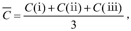
1.任一种基本情况出现次数不为0:


2.存在一种基本情况出现次数为0:若C(ⅰ)=0时,该道路中段和南(东)段拥堵;C(ⅱ)=0时,该道路北(西)段和南(东)段拥堵;C(ⅲ)=0时,该道路北(西)段和中段拥堵;2. There is a basic situation where the number of occurrences is 0: if C(i)=0, the middle and south (east) sections of the road are congested; when C(ii)=0, the north (west) and south ( The east) section is congested; when C(iii)=0, the north (west) section and the middle section of the road are congested;
3.存在两种基本情况出现次数为0:C(ⅰ)=0且C(ⅱ)=0时,该道路南(东)段拥堵;C(ⅰ)=0且C(ⅲ)=0时,该道路中段拥堵;C(ⅱ)=0且C(ⅲ)=0时,该道路北(西)段拥堵。3. There are two basic situations where the number of occurrences is 0: when C(i)=0 and C(ii)=0, the south (east) section of the road is congested; when C(i)=0 and C(iii)=0 , the middle section of the road is congested; when C(ii)=0 and C(iii)=0, the north (west) section of the road is congested.
为了避免计算机产生识别误差,采取两层分类的方法来确保结果的准确性:In order to avoid computer recognition errors, a two-layer classification method is adopted to ensure the accuracy of the results:
首先将道路的拥堵路段根据编号分为连续和间断两种情况,再根据连续和间断的具体情况进行具体分类,得到编号分类结果,编号分类结果由基本拥堵情况组成,根据各种基本拥堵情况的出现频率再一次进行分类。First, the congested sections of the road are divided into two situations: continuous and discontinuous according to the number, and then the specific classification is carried out according to the specific conditions of continuous and discontinuous, and the numbered classification result is obtained. The numbered classification result is composed of basic congestion conditions. The frequency of occurrence is again classified.
实施例:Example:
1)获取并判断车辆的GPS数据的可用性;1) Obtain and judge the availability of GPS data of the vehicle;
获取GPS设备的用户ID、经纬度和传送数据的时间戳,根据GPS数据的经纬度是否在目标区域内确定可用性;Obtain the user ID, latitude and longitude of the GPS device and the timestamp of the transmitted data, and determine the availability according to whether the latitude and longitude of the GPS data is within the target area;
GPS数据p(x,y),x为经度,y为纬度,精度精确到小数点后五位,例p(104.07502,30.72682)。GPS data p(x,y), x is longitude, y is latitude, and the precision is accurate to five decimal places, for example p(104.07502,30.72682).
时间戳为Unix戳,例1477969186。Timestamps are Unix stamps, e.g. 1477969186.
2)根据交叉口区域内车辆的数量变化识别道路拥堵区域,如果两个拥堵区域由一个路段直接连接,则这两个拥堵区域是相邻的,将相邻的拥堵区域合并,得到合并拥堵区域;2) Identify road congested areas according to the change in the number of vehicles in the intersection area. If two congested areas are directly connected by a road section, then the two congested areas are adjacent, and the adjacent congested areas are merged to obtain a combined congested area ;
交叉口的数据格式如下:The data format of the intersection is as follows:
假设交叉口中心坐标为(r,s),r为经度,s为纬度,精度精确到小数点后五位,例(104.07512,30.72702)。设A’=(r-c,r+c,s-c,s+c)为交叉口区域,其中c为常数,取值范围为[0.00030,0.00090],建议取值0.00050。A’=(104.07462,104.07562,30.72652,30.72752),GPS数据p(104.07502,30.72682),满足条件:104.07462≤104.07502≤104.07562且30.72652≤30.72682≤30.72752,该数据是可用的。T时刻和T+t时刻都是十位的Unix时间戳的表达形式,如1477969154;t的取值范围[240,420],建议取值为300。T=1477969154时在交叉口区域内的车辆组成一个车辆子群P={p(x,y)|p∈A’},车辆子群P的可用车辆GPS数据个数nT=140;T+t=1477969454车辆子群P的可用车辆GPS数据个数为nT+t=100。车辆子群P减少量
3)按地标、范围的形式生成合并拥堵区域的位置和范围;3) Generate the location and range of the merged congestion area in the form of landmarks and ranges;
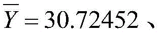
合并拥堵区域按“地标+范围”的形式进行标识,分别计算合并拥堵区域内包含的m个交叉口中心点的横坐标平均值

若4×10^10×D(X)D(Y)≤B定义为“小范围”;若B≤4×10^10×D(X)D(Y)≤2B定义为“中等范围”;若4×10^10×D(X)D(Y)≥2B定义为“大范围”;以

举例如下:有两个交叉口,坐标分别为(104.07512,30.72702)和(104.07812,30.72202),横坐标平均值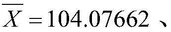

4)分析道路中拥堵路段的分布特征,将拥堵路段按所属道路进行分类,并按编号从小到大进行排序,确定编号分类结果;4) Analyze the distribution characteristics of the congested road sections in the road, classify the congested road sections according to the road to which they belong, and sort them according to the number from small to large, and determine the result of the number classification;
道路的路段按从北往南、从西往东的顺序从小到大依次编号。编号值为路段属性之一,道路一共有N个路段,编号值为1,2,…,N。例如,中央大街为东西向道路,有五个路段,从西往东依次编号为1,2,3,4,5。The sections of the road are numbered in descending order from north to south and west to east. The number value is one of the attributes of the road segment. The road has a total of N road segments, and the number value is 1,2,…,N. For example, Central Street is an east-west road with five sections, numbered 1, 2, 3, 4, and 5 from west to east.
根据车流速度确定路段是否拥堵,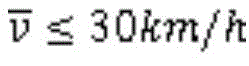
一条道路的拥堵路段为一条数据,数据格式如下:A congested section of a road is a piece of data, and the data format is as follows:
其中q1<q2<q3<q4。Where q1<q2<q3<q4.
举例来说明上述方法的使用。Example to illustrate the use of the above method.
皇后大道一共有5个路段,N=5,皇后大道的拥堵路段的数据格式如下:There are a total of 5 road sections on Queen's Road, N=5. The data format of the congested road sections on Queen's Road is as follows:
拥堵编号q1(1)间断,拥堵编号q2(3)和拥堵编号q3(4)连续。The congestion number q1(1) is discontinuous, and the congestion number q2(3) and the congestion number q3(4) are continuous.
编号间断的拥堵编号q1(1):Numbered intermittent congestion number q1(1):

编号连续的拥堵编号q2(3)和拥堵编号q3(4):Numbered consecutive congestion numbers q2(3) and congestion numbers q3(4):
ⅰⅱⅲ三种基本情况出现的次数分别为C(ⅰ)=1,C(ⅱ)=1,C(ⅲ)=1,任一种基本情况出现次数不为0。ⅰⅱⅲThe occurrence times of the three basic conditions are C(i)=1, C(ii)=1, C(iii)=1, and the occurrence times of any one of the basic conditions is not 0.
三种基本情况出现的平均次数


以上所述仅是本发明的优选实施方式,应当指出,对于本技术领域的普通技术人员来说,在不脱离本发明技术原理的前提下,还可以做出若干改进和变形,这些改进和变形也应视为本发明的保护范围。The above are only the preferred embodiments of the present invention. It should be pointed out that for those skilled in the art, without departing from the technical principles of the present invention, several improvements and modifications can be made. These improvements and modifications It should also be regarded as the protection scope of the present invention.
Claims (5)


Priority Applications (1)
| Application Number | Priority Date | Filing Date | Title |
|---|---|---|---|
| CN201810724855.7A CN108806257B (en) | 2018-07-04 | 2018-07-04 | Method for identifying congested areas and congested road sections |
Applications Claiming Priority (1)
| Application Number | Priority Date | Filing Date | Title |
|---|---|---|---|
| CN201810724855.7A CN108806257B (en) | 2018-07-04 | 2018-07-04 | Method for identifying congested areas and congested road sections |
Publications (2)
| Publication Number | Publication Date |
|---|---|
| CN108806257A CN108806257A (en) | 2018-11-13 |
| CN108806257B true CN108806257B (en) | 2020-11-10 |
Family
ID=64074384
Family Applications (1)
| Application Number | Title | Priority Date | Filing Date |
|---|---|---|---|
| CN201810724855.7A Expired - Fee Related CN108806257B (en) | 2018-07-04 | 2018-07-04 | Method for identifying congested areas and congested road sections |
Country Status (1)
| Country | Link |
|---|---|
| CN (1) | CN108806257B (en) |
Families Citing this family (4)
| Publication number | Priority date | Publication date | Assignee | Title |
|---|---|---|---|---|
| CN110047288A (en) * | 2019-04-24 | 2019-07-23 | 葛志凯 | Alleviate the method and system of congestion in road |
| CN111860396A (en) * | 2020-07-28 | 2020-10-30 | 江苏中设集团股份有限公司 | A method for identifying and summarizing the current area congestion status of vehicles |
| CN115148018B (en) * | 2021-03-31 | 2024-05-24 | 海信集团控股股份有限公司 | Traffic event detection device and method |
| CN117711610B (en) * | 2024-02-05 | 2024-04-26 | 四川省医学科学院·四川省人民医院 | Remote consultation vehicle system of networked MDT multidisciplinary |
Citations (11)
| Publication number | Priority date | Publication date | Assignee | Title |
|---|---|---|---|---|
| CN101604478A (en) * | 2009-06-18 | 2009-12-16 | 北京九州联宇信息技术有限公司 | A kind of disposal route of dynamic information and system |
| CN101710449A (en) * | 2009-12-04 | 2010-05-19 | 吉林大学 | Traffic flow running rate recognizing method based on bus GPS data |
| CN102637357A (en) * | 2012-03-27 | 2012-08-15 | 山东大学 | Regional traffic state assessment method |
| CN102663887A (en) * | 2012-04-13 | 2012-09-12 | 浙江工业大学 | Road traffic information cloud computing and cloud service implementation system and method based on Internet of Things technology |
| CN103065472A (en) * | 2012-12-24 | 2013-04-24 | 中国科学院深圳先进技术研究院 | Real-time traffic status analysis method and real-time traffic status analysis system |
| CN104318766A (en) * | 2014-10-22 | 2015-01-28 | 北京建筑大学 | Bus GPS track data road network matching method |
| CN105702042A (en) * | 2016-04-22 | 2016-06-22 | 北京国交信通科技发展有限公司 | Road congestion judgment method according to locating information of key operating vehicles |
| CN105894802A (en) * | 2015-04-10 | 2016-08-24 | 杭州远眺科技有限公司 | GPS data-based traffic congestion propagation path calculating method |
| CN106408943A (en) * | 2016-11-17 | 2017-02-15 | 华南理工大学 | Road-network traffic jam discrimination method based on macroscopic fundamental diagram |
| CN107123296A (en) * | 2017-06-09 | 2017-09-01 | 安徽富煌科技股份有限公司 | A kind of global unobstructed degree voice announcer of circuit |
| CN108109382A (en) * | 2018-02-05 | 2018-06-01 | 青岛大学 | A kind of congestion points based on composite network, congestion line, the discovery method of congestion regions |
Family Cites Families (5)
| Publication number | Priority date | Publication date | Assignee | Title |
|---|---|---|---|---|
| CN102368355B (en) * | 2011-10-19 | 2014-04-02 | 北京世纪高通科技有限公司 | Method and system for rapid updating of traffic data |
| CN102968901B (en) * | 2012-11-30 | 2014-11-26 | 青岛海信网络科技股份有限公司 | Method for acquiring regional congestion information and regional congestion analyzing device |
| CN103226892B (en) * | 2013-04-08 | 2016-02-03 | 福建工程学院 | A kind of road congestion state discovery method of Optimization-type |
| CN103730008A (en) * | 2014-01-15 | 2014-04-16 | 汪涛 | Bus congestion degree analysis method based on real-time data of bus GPS (Global Position System) and IC (Integrated Circuit) cards |
| US10163339B2 (en) * | 2016-12-13 | 2018-12-25 | Sap Se | Monitoring traffic congestion |
-
2018
- 2018-07-04 CN CN201810724855.7A patent/CN108806257B/en not_active Expired - Fee Related
Patent Citations (11)
| Publication number | Priority date | Publication date | Assignee | Title |
|---|---|---|---|---|
| CN101604478A (en) * | 2009-06-18 | 2009-12-16 | 北京九州联宇信息技术有限公司 | A kind of disposal route of dynamic information and system |
| CN101710449A (en) * | 2009-12-04 | 2010-05-19 | 吉林大学 | Traffic flow running rate recognizing method based on bus GPS data |
| CN102637357A (en) * | 2012-03-27 | 2012-08-15 | 山东大学 | Regional traffic state assessment method |
| CN102663887A (en) * | 2012-04-13 | 2012-09-12 | 浙江工业大学 | Road traffic information cloud computing and cloud service implementation system and method based on Internet of Things technology |
| CN103065472A (en) * | 2012-12-24 | 2013-04-24 | 中国科学院深圳先进技术研究院 | Real-time traffic status analysis method and real-time traffic status analysis system |
| CN104318766A (en) * | 2014-10-22 | 2015-01-28 | 北京建筑大学 | Bus GPS track data road network matching method |
| CN105894802A (en) * | 2015-04-10 | 2016-08-24 | 杭州远眺科技有限公司 | GPS data-based traffic congestion propagation path calculating method |
| CN105702042A (en) * | 2016-04-22 | 2016-06-22 | 北京国交信通科技发展有限公司 | Road congestion judgment method according to locating information of key operating vehicles |
| CN106408943A (en) * | 2016-11-17 | 2017-02-15 | 华南理工大学 | Road-network traffic jam discrimination method based on macroscopic fundamental diagram |
| CN107123296A (en) * | 2017-06-09 | 2017-09-01 | 安徽富煌科技股份有限公司 | A kind of global unobstructed degree voice announcer of circuit |
| CN108109382A (en) * | 2018-02-05 | 2018-06-01 | 青岛大学 | A kind of congestion points based on composite network, congestion line, the discovery method of congestion regions |
Non-Patent Citations (3)
| Title |
|---|
| Mining interesting locations and travel sequences from GPS trajectories;Zheng Y等;《Proc of internationai conference on world wide web》;20091215;全文 * |
| 基于GPS轨迹的城市拥堵区域挖掘与分析;武兴业等;《计算机技术与发展》;20160731;第26卷(第7期);全文 * |
| 基于出租车GPS数据的城市道路拥堵判别;郭雪婷等;《交通信息与安全》;20130531;第31卷(第5期);全文 * |
Also Published As
| Publication number | Publication date |
|---|---|
| CN108806257A (en) | 2018-11-13 |
Similar Documents
| Publication | Publication Date | Title |
|---|---|---|
| CN108806257B (en) | Method for identifying congested areas and congested road sections | |
| CN110516708B (en) | Path prediction method based on track and road network matching | |
| CN100463009C (en) | A traffic information fusion processing method and system | |
| CN110909788B (en) | A method for road intersection location recognition in trajectory data based on statistical clustering | |
| CN113950611B (en) | Method and data processing system for predicting road properties | |
| US20200158515A1 (en) | Method, apparatus, and system for categorizing a stay point based on probe data | |
| CN108961758B (en) | Road junction widening lane detection method based on gradient lifting decision tree | |
| CN109215343B (en) | Dynamic identification method and system of road network congestion area based on community discovery | |
| CN101694706A (en) | Modeling method of characteristics of population space-time dynamic moving based on multisource data fusion | |
| CN110555544A (en) | A Method of Traffic Demand Estimation Based on GPS Navigation Data | |
| US11085791B2 (en) | Method, apparatus, and computer program product for on-street parking localization | |
| CN108876475A (en) | City functional area identification method based on interest point acquisition, server and storage medium | |
| CN110400461A (en) | A road network change detection method | |
| CN114694066A (en) | Image processing method and device, electronic equipment and storage medium | |
| CN107525513A (en) | The optimal transit point system of selection of finite constraint condition based on existing navigation system | |
| US20220180741A1 (en) | Method, apparatus and computer program product for detecting a lane closure using probe data | |
| CN108615357A (en) | A kind of pedestrian's street crossing service level section grade determines method and system | |
| CN108710996A (en) | Gather region hotel addressing appraisal procedure in hotel based on tourism trip time and space usage | |
| Gao et al. | Urban Tourism Traffic Analysis Zone Division Based on Floating Car Data | |
| US11580850B2 (en) | Method, apparatus and computer program product for determining lane status confidence indicators using probe data | |
| CN112611390B (en) | Classical line acquisition method and device in navigation system | |
| CN111860396A (en) | A method for identifying and summarizing the current area congestion status of vehicles | |
| Keler et al. | Detecting travel time variations in urban road networks by taxi trajectory intersections | |
| CN114999151B (en) | Density-based urban traffic flow hierarchical analysis method and device in GPS track | |
| TWI672642B (en) | People count statistic system and method thereof |
Legal Events
| Date | Code | Title | Description |
|---|---|---|---|
| PB01 | Publication | ||
| PB01 | Publication | ||
| SE01 | Entry into force of request for substantive examination | ||
| SE01 | Entry into force of request for substantive examination | ||
| GR01 | Patent grant | ||
| GR01 | Patent grant | ||
| CF01 | Termination of patent right due to non-payment of annual fee | ||
| CF01 | Termination of patent right due to non-payment of annual fee |
Granted publication date: 20201110 |