CN106791700B - Enterprise critical area personnel path safety monitoring system and method - Google Patents
Enterprise critical area personnel path safety monitoring system and method Download PDFInfo
- Publication number
- CN106791700B CN106791700B CN201710040464.9A CN201710040464A CN106791700B CN 106791700 B CN106791700 B CN 106791700B CN 201710040464 A CN201710040464 A CN 201710040464A CN 106791700 B CN106791700 B CN 106791700B
- Authority
- CN
- China
- Prior art keywords
- information
- monitoring
- coordinates
- area
- alarm
- Prior art date
- Legal status (The legal status is an assumption and is not a legal conclusion. Google has not performed a legal analysis and makes no representation as to the accuracy of the status listed.)
- Active
Links
Images


Classifications
-
- H—ELECTRICITY
- H04—ELECTRIC COMMUNICATION TECHNIQUE
- H04N—PICTORIAL COMMUNICATION, e.g. TELEVISION
- H04N7/00—Television systems
- H04N7/18—Closed-circuit television [CCTV] systems, i.e. systems in which the video signal is not broadcast
- H04N7/181—Closed-circuit television [CCTV] systems, i.e. systems in which the video signal is not broadcast for receiving images from a plurality of remote sources
-
- G—PHYSICS
- G06—COMPUTING OR CALCULATING; COUNTING
- G06F—ELECTRIC DIGITAL DATA PROCESSING
- G06F18/00—Pattern recognition
- G06F18/20—Analysing
- G06F18/21—Design or setup of recognition systems or techniques; Extraction of features in feature space; Blind source separation
- G06F18/214—Generating training patterns; Bootstrap methods, e.g. bagging or boosting
-
- G—PHYSICS
- G06—COMPUTING OR CALCULATING; COUNTING
- G06V—IMAGE OR VIDEO RECOGNITION OR UNDERSTANDING
- G06V10/00—Arrangements for image or video recognition or understanding
- G06V10/20—Image preprocessing
- G06V10/25—Determination of region of interest [ROI] or a volume of interest [VOI]
-
- G—PHYSICS
- G06—COMPUTING OR CALCULATING; COUNTING
- G06V—IMAGE OR VIDEO RECOGNITION OR UNDERSTANDING
- G06V20/00—Scenes; Scene-specific elements
- G06V20/40—Scenes; Scene-specific elements in video content
- G06V20/41—Higher-level, semantic clustering, classification or understanding of video scenes, e.g. detection, labelling or Markovian modelling of sport events or news items
-
- G—PHYSICS
- G06—COMPUTING OR CALCULATING; COUNTING
- G06V—IMAGE OR VIDEO RECOGNITION OR UNDERSTANDING
- G06V20/00—Scenes; Scene-specific elements
- G06V20/40—Scenes; Scene-specific elements in video content
- G06V20/44—Event detection
Landscapes
- Engineering & Computer Science (AREA)
- Theoretical Computer Science (AREA)
- Physics & Mathematics (AREA)
- General Physics & Mathematics (AREA)
- Multimedia (AREA)
- Data Mining & Analysis (AREA)
- Bioinformatics & Cheminformatics (AREA)
- Artificial Intelligence (AREA)
- Life Sciences & Earth Sciences (AREA)
- Bioinformatics & Computational Biology (AREA)
- Computer Vision & Pattern Recognition (AREA)
- Evolutionary Biology (AREA)
- Evolutionary Computation (AREA)
- General Engineering & Computer Science (AREA)
- Computational Linguistics (AREA)
- Software Systems (AREA)
- Signal Processing (AREA)
- Alarm Systems (AREA)
Abstract
一种企业关键区域人员路径安全监控系统及方法,系统包括图像采集装置、图像处理装置、输出报警装置和视频监控装置;方法包括非线性拟合标定法和快速检索方法;采用非线性拟合标定法。以作业人员位置信息为基础,实现了实时准确的人员定位;以监控区域和设备的世界坐标为基准,实现了场区平面俯视图模型的建立;以作业票输入信息为根据,实现了监控区域内规范路径、危险区域和工作区域的规划;以快速检索方法为依据,实现了有效视频记录信息的快速追溯。既保证了监控系统的实时性,还实现了高效的监控管理和规范的操作行为。

A system and method for monitoring personnel path safety in key areas of an enterprise. The system includes an image acquisition device, an image processing device, an output alarm device, and a video monitoring device; the method includes a nonlinear fitting calibration method and a fast retrieval method; the nonlinear fitting calibration method is used Law. Real-time and accurate personnel positioning is realized based on the position information of the operators; the establishment of the plan view model of the site is realized based on the world coordinates of the monitoring area and equipment; Standardize the planning of paths, dangerous areas and work areas; based on the rapid retrieval method, the rapid traceability of effective video recording information is realized. It not only ensures the real-time performance of the monitoring system, but also realizes efficient monitoring management and standardized operation behavior.
Description
技术领域technical field
本发明涉及监控系统及方法,特别涉及一种企业关键区域人员路径安全监控系统及方法。The invention relates to a monitoring system and method, in particular to a system and method for monitoring the safety of personnel paths in key areas of an enterprise.
背景技术Background technique
企业人员行为安全问题已经成为企业生产中的重中之重,核心问题在于安全制度的不够完善,主要体现于作业人员的违规操作和监控管理人员不能及时有效地发现违规行为,这就为安全事故的产生埋下了祸源。The behavior safety of enterprise personnel has become the top priority in the production of enterprises. The core problem is that the safety system is not perfect, which is mainly reflected in the illegal operation of the operators and the inability of the monitoring and management personnel to discover the violations in a timely and effective manner. This is a safety accident. The emergence of the planted the source of disaster.
而现阶段安防监控系统虽然能实时、形象、真实的反应场区中的被监控对象,但是不能为管理人员提供有效的位置信息,存储设备存储的大量视频信息又不便于管理人员查询,监控的工作大多还是由人眼去识别,违章违规操作信息还处于人为判断的阶段。这样不仅大大加重了监控人员的工作负担,同时还不利于企业生产安全制度的完善,最主要的是没有实现真正意义上的监控。我们希望找到一种既可以减轻管理人员负担又能规范作业人员现场工作的监控方法,能在实时、形象、真实反应作业人员行为信息的情况下,为管理人员提供准确的作业人员位置、直观的监控区域信息和有效的违规信息。At present, although the security monitoring system can reflect the monitored objects in the real-time, image and real-time area, it cannot provide effective location information for the management personnel, and the large amount of video information stored in the storage device is not convenient for the management personnel to query. Most of the work is still identified by human eyes, and the information on illegal operations is still in the stage of human judgment. This not only greatly increases the workload of the monitoring personnel, but also is not conducive to the improvement of the production safety system of the enterprise. The most important thing is that the monitoring in the true sense has not been realized. We hope to find a monitoring method that can not only reduce the burden on the management personnel but also standardize the on-site work of the operators, and can provide the management personnel with accurate location of the operators and intuitive monitoring of the operator's behavior information in real time, visually and truly. Monitor area information and valid violation information.
发明内容Contents of the invention
为了解决背景技术中所述问题,本发明提供一种企业关键区域人员路径安全监控系统,采用非线性拟合标定法。以作业人员位置信息为基础,实现了实时准确的人员定位;以监控区域和设备的世界坐标为基准,实现了场区平面俯视图模型的建立;以作业票输入信息为根据,实现了监控区域内规范路径、危险区域和工作区域的规划;以快速检索方法为依据,实现了有效视频记录信息的快速追溯。既保证了监控系统的实时性,还实现了高效的监控管理和规范的操作行为。In order to solve the problems described in the background technology, the present invention provides a safety monitoring system for personnel paths in key areas of an enterprise, which adopts a nonlinear fitting calibration method. Real-time and accurate personnel positioning is realized based on the location information of the operators; the establishment of the plan view model of the site is realized based on the world coordinates of the monitoring area and equipment; based on the input information of the job ticket, the monitoring area Standardize the planning of paths, dangerous areas and work areas; based on the rapid retrieval method, the rapid traceability of effective video recording information is realized. It not only ensures the real-time performance of the monitoring system, but also realizes efficient monitoring management and standardized operation behavior.
为了达到上述目的,本发明采用以下技术方案实现:In order to achieve the above object, the present invention adopts the following technical solutions to realize:
一种企业关键区域人员路径安全监控系统,包括图像采集装置、图像处理装置、输出报警装置和视频监控装置;A safety monitoring system for personnel paths in key areas of an enterprise, including an image acquisition device, an image processing device, an output alarm device, and a video monitoring device;
所述图像处理装置为NI CompactRIO嵌入式系统,包括嵌入式控制器和可编程FPGA以及工业I/O模块,图像处理装置内嵌实时操作系统;Described image processing device is NI CompactRIO embedded system, comprises embedded controller and programmable FPGA and industrial I/O module, and image processing device embeds real-time operating system;
所述图像采集装置包括交换机和多个网络摄像头,网络摄像头通过交换机与图像处理装置相连接;The image acquisition device includes a switch and a plurality of network cameras, and the network cameras are connected with the image processing device through the switch;
所述视频监控装置包括工控机和显示器,工控机与图像处理装置进行通讯连接;The video monitoring device includes an industrial computer and a display, and the industrial computer communicates with the image processing device;
所述输出报警装置为报警器,图像处理装置通过I/O口与输出报警装置连接;The output alarm device is an alarm, and the image processing device is connected with the output alarm device through the I/O port;
所述图像处理装置分别与图像采集装置、输出报警装置、视频监控装置连接,构成企业关键区域人员路径安全监控系统;The image processing device is respectively connected with the image acquisition device, the output alarm device, and the video monitoring device to form a personnel path safety monitoring system in key areas of the enterprise;
所述图像采集装置以图像信息的形式实时采集区域内作业人员的行为信息,图像处理装置对获取的图像数据进行处理并将信息分别传送到视频监控装置和输出报警装置;The image acquisition device collects the behavior information of the operators in the area in real time in the form of image information, and the image processing device processes the acquired image data and transmits the information to the video monitoring device and the output alarm device respectively;
所述的图像处理装置中的图像处理软件采用非线性透镜畸变校正算法校正每个采集图像ROI(有效区域),采用非线性拟合标定方法使图像中的像素坐标与世界坐标之间形成映射关系,根据实际设备和监控区域的世界坐标将图像采集装置获取图像信息中的坐标进行拼接,构成完整场区的监控俯视图;采用快速检索方法,进行有效路径视频记录信息的快速追溯;The image processing software in the image processing device uses a nonlinear lens distortion correction algorithm to correct each captured image ROI (effective area), and uses a nonlinear fitting calibration method to form a mapping relationship between the pixel coordinates in the image and the world coordinates According to the actual equipment and the world coordinates of the monitoring area, the coordinates in the image information acquired by the image acquisition device are spliced to form a complete monitoring top view of the site; the rapid retrieval method is used to quickly trace the video recording information of the effective path;
所述的输出报警装置将图像处理装置处理后的报警信息用电信号的形式通过报警器反馈给监控管理人员及作业人员。The output alarm device feeds back the alarm information processed by the image processing device in the form of an electrical signal to the monitoring management personnel and operators through the alarm device.
一种企业关键区域人员路径安全监控方法,包括以下方法:A method for safety monitoring of personnel paths in key areas of an enterprise, comprising the following methods:
(1)非线性拟合标定法:(1) Nonlinear fitting calibration method:
步骤一、在离线的情况下,将每个摄像头获取初始图片,传递给图像处理装置;
步骤二、图像处理装置中的图像处理软件对图片内的有效区域进行透镜误差和非线性透镜畸变的校正即图片预处理;
步骤三、图像处理装置中的图像处理软件在每个摄像头获取的初始图片中的有效区域内铺设标准网格,网格的疏密程度由样本训练时采样点的多少决定,根据用户的具体要求可进行调节;Step 3. The image processing software in the image processing device lays a standard grid in the effective area of the initial picture acquired by each camera. The density of the grid is determined by the number of sampling points during sample training. According to the specific requirements of the user Can be adjusted;
步骤四、图像处理软件会在畸变校正后的初始图片标准网格内进行采点即采集训练样本;Step 4. The image processing software will collect points in the standard grid of the original image after distortion correction, that is, collect training samples;
步骤五、基于非线性拟合标定法对采集的样本进行训练,使像素坐标与世界坐标形成映射;Step 5, based on the nonlinear fitting calibration method, the collected samples are trained, so that the pixel coordinates and the world coordinates are mapped;
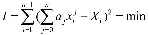
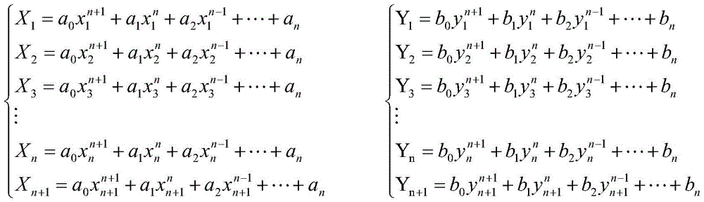
进一步,非线性拟合标定公式如下:Further, the nonlinear fitting calibration formula is as follows:

其中Xi和Yi为训练样本的世界坐标,xi和yi为训练样本的像素坐标i∈(1,n+1);通过样本训练求解方程,确定拟合系数aj和bj其中j∈(0,n),通过最小二乘法修正拟合系数aj,即误差平法和最小;公式如下:Where Xi and Yi are the world coordinates of the training samples, xi and yi are the pixel coordinates i∈(1,n+1) of the training samples; solve the equation through sample training, and determine the fitting coefficients aj and bj where j∈(0,n ), the fitting coefficient aj is corrected by the least square method, that is, the error square method and the minimum; the formula is as follows:
同理修正拟合系数bj,确定拟合系数aj和bj其中j∈(0,n),实现像素坐标与世界坐标之间的映射;In the same way, modify the fitting coefficient bj, determine the fitting coefficients aj and bj where j∈(0,n), and realize the mapping between pixel coordinates and world coordinates;
步骤六、将每个图片的训练结果即参数Origin、X Axis Point和拟合系数保存在图像处理软件中;Step 6, save the training result of each picture, i.e. parameter Origin, X Axis Point and fitting coefficient in the image processing software;
进一步,参数Origin为训练后的原点坐标,参数X Axis Point为训练后的x轴上一点坐标;保存参数的目的在于:使Origin的坐标与标准网格原点(默认左上采样点为原点)重合,使x轴与标准网格的水平方向重合,在默认偏差角度为零度的情况下,y轴是通过已重合的x轴间接确定的;Further, the parameter Origin is the coordinates of the origin after training, and the parameter X Axis Point is the coordinates of a point on the x-axis after training; the purpose of saving the parameters is to make the coordinates of Origin coincide with the origin of the standard grid (the default upper left sampling point is the origin), Make the x-axis coincide with the horizontal direction of the standard grid. When the default deviation angle is zero degrees, the y-axis is determined indirectly through the coincident x-axis;
步骤七、按照实际世界坐标将所有标定区域的坐标进行拼接,即构建整个场区的平面俯视图,Step 7. According to the actual world coordinates, the coordinates of all the calibration areas are stitched together, that is, the plane top view of the entire field area is constructed.
进一步,图片实际坐标=图片训练后坐标+相对世界坐标;Further, the actual coordinates of the picture = the coordinates after training of the picture + the relative world coordinates;
其中,相对世界坐标,默认以场区的左上监控区域为基准,相对世界坐标为该区域的右下采样点坐标;Among them, the relative world coordinates are based on the upper left monitoring area of the site by default, and the relative world coordinates are the lower right sampling point coordinates of the area;
步骤八、每个图片完成标定后,即可进行图片有效区域的拼接,最终形成整个场区的监控俯视图,监控视频中作业人员的位置信息可视为俯视图中移动点的坐标信息;Step 8. After each picture is calibrated, the effective area of the picture can be stitched together, and finally a monitoring overhead view of the entire field is formed. The position information of the operator in the monitoring video can be regarded as the coordinate information of the moving point in the overhead view;
步骤九、作业人员的标定,图像采集装置实时采集图像信息,图像处理软件对采集到的图像信息进行处理,并根据上述方法对作业人员进行在线标定;Step 9, the calibration of the operator, the image acquisition device collects image information in real time, the image processing software processes the collected image information, and performs online calibration of the operator according to the above method;
进一步,作业人员的标定具体为:首先将采集图片进行灰度处理,然后利用背景差除法对图片进行相减,再对相减后的图片进行二值化处理,最后选取二值化图片中的最低点像素坐标作为人员的像素坐标;利用上述标定方法对人员进行在线标定,得到作业人员的世界坐标,并反映在监控俯视图上,实现作业人员的准确定位;Further, the calibration of the operator is specifically as follows: firstly, grayscale processing is performed on the collected pictures, and then the pictures are subtracted by the background subtraction method, and then the subtracted pictures are binarized, and finally the binarized pictures are selected. The pixel coordinates of the lowest point are used as the pixel coordinates of the personnel; the above-mentioned calibration method is used to calibrate the personnel online to obtain the world coordinates of the operator, which is reflected on the monitoring top view to realize the accurate positioning of the operator;
(2)快速检索方法:(2) Quick search method:
步骤一、根据作业票确定输入信息,输入信息是可在视频监控装置中进行修改的和存储的表格;
进一步,输入信息表格中包括:管理人员姓名,设备名称,设备型号,作业时间,作业人员姓名及备注等信息;Further, the input information form includes information such as the name of the manager, the name of the equipment, the model of the equipment, the operating time, the name of the operator, and notes;
步骤二、根据输入信息设置具体的安全作业图,实现视频监控装置中操作系统的区域规划功能;
进一步,区域规划的目的在于为报警条件提供实际坐标参考;安全作业图是管理人员在已完成畸变校正和标定训练的初始图片上根据作业票中设备和区域的实际位置规定的,图中包括规范路径,作业区域和危险区域;Furthermore, the purpose of area planning is to provide actual coordinate reference for alarm conditions; the safety operation map is stipulated by managers on the initial picture that has completed distortion correction and calibration training according to the actual location of equipment and areas in the work ticket. paths, work areas and hazardous areas;
步骤三、根据不同的作业票建立安全作业图库,管理人员可在视频监控装置中操作系统进行库的修改和存储操作;Step 3. Establish a safe job library according to different job tickets, and the management personnel can modify and store the library in the operating system of the video monitoring device;
进一步,安全作业图库为每一张作业票设置安全作业图的集合;Further, the safety operation gallery sets a collection of safety operation diagrams for each operation ticket;
步骤四、针对报警信息(报警信息即输出报警装置的报警信号、视频信息、违章日志等),确定发生报警区域;Step 4, for the alarm information (the alarm information is the alarm signal, video information, violation log, etc. of the output alarm device), determine the alarm area;
步骤五、根据发生报警区域,确定摄像头机位,摄像头机位即摄像头所处监控区域位置;Step 5, according to the alarm area, determine the camera position, the camera position is the position of the monitoring area where the camera is located;
步骤六、根据摄像头机位查询该摄像头存储的报警信息(即违规日志和记录视频);Step 6. Query the alarm information stored by the camera according to the camera position (that is, the violation log and recorded video);
步骤七、确定报警时间,即将录像的时间信息与作业票输入信息中的时间进行匹配,并同作业票输入信息进行二次核对;Step 7, determine the alarm time, match the time information of the video recording with the time in the input information of the job ticket, and carry out secondary check with the input information of the job ticket;
步骤八、根据已确定的作业票信息,确定具体作业人员;Step 8. Determine the specific operator according to the determined job ticket information;
步骤九、根据具体作业人员的作业票信息,确定其工作路径(即作业人员现场操作时管理人员开放的规范路径),从而确定其经过和工作的监控区域,回调整个视频链,视频链即多个摄像头采集存储的视频信息,实现智能监控系统的快速检索功能。Step 9. According to the job ticket information of specific operators, determine their work path (that is, the standardized path opened by managers when operators operate on site), so as to determine the monitoring area where they pass and work, and call back the entire video chain. The video chain is multiple A camera collects and stores video information to realize the fast retrieval function of the intelligent monitoring system.
与现有技术相比,本发明的有益效果是:Compared with prior art, the beneficial effect of the present invention is:
1、在监控管理过程中,采用非线性拟合标定的方法实现区域监控,保证了实时视频的监控,利用基于非线性拟合标定法还可以准确地反应出作业人员位置信息,给监控管理人员提供了有效的人员定位信息,便于监控管理人员及时地发现监控区域出现的异常情况。1. In the monitoring and management process, the non-linear fitting and calibration method is used to realize regional monitoring, which ensures real-time video monitoring. Using the non-linear fitting and calibration method can also accurately reflect the location information of the operators and provide monitoring and management personnel Effective personnel positioning information is provided, which is convenient for monitoring and management personnel to discover abnormal situations in the monitoring area in a timely manner.
2、在监控管理过程中,根据实际设备和区域的世界坐标建立的整个场区的平面俯视图,不仅可以为管理人员反映直观的监控区域信息,还便于管理人员对监控全局进行指挥和管理。2. In the monitoring and management process, the plane top view of the entire site established according to the actual equipment and the world coordinates of the area can not only reflect the intuitive monitoring area information for the management personnel, but also facilitate the management personnel to command and manage the overall monitoring.
3、在监控管理过程中,根据具体作业票信息设置的安全作业图,规范作业人员工作行为(工作行为即通过规范路径到达工作区域进行正规操作)。同时可实现违规报警及记录,达到了智能监控的目的。3. In the process of monitoring and management, according to the safety operation diagram set by the specific job ticket information, the work behavior of the operators is regulated (the work behavior is to reach the work area through a standardized path for regular operations). At the same time, it can realize the alarm and record of violations, and achieve the purpose of intelligent monitoring.
4、在监控管理过程中,利用快速检索追溯录像记录,可以为监控管理人员快速地提供有效的记录信息,从而达到完善监管制度的目的。4. In the process of monitoring and management, using fast retrieval to trace video records can quickly provide effective record information for monitoring and management personnel, so as to achieve the purpose of perfecting the supervision system.
附图说明Description of drawings
图1本发明的系统原理示意图;Fig. 1 schematic diagram of system principle of the present invention;
图2本发明的系统结构示意图;Fig. 2 is a schematic structural diagram of the system of the present invention;
图3本发明的非线性拟合标定法流程图;Fig. 3 non-linear fitting calibration method flowchart of the present invention;
图4本发明的基于非线性拟合标定法建立的场区俯视图;Fig. 4 is the top view of the field area established based on the nonlinear fitting calibration method of the present invention;
图5本发明的快速检索方法流程图。Fig. 5 is a flow chart of the fast retrieval method of the present invention.
具体实施方式Detailed ways
以下结合附图对本发明提供的具体实施方式进行详细说明。The specific embodiments provided by the present invention will be described in detail below in conjunction with the accompanying drawings.
如图1所示,一种企业关键区域人员路径安全监控系统,包括图像采集装置、图像处理装置、输出报警装置和视频监控装置;As shown in Figure 1, a security monitoring system for personnel paths in key areas of an enterprise includes an image acquisition device, an image processing device, an output alarm device and a video monitoring device;
如图2所示,所述图像处理装置为NI CompactRIO嵌入式系统,包括嵌入式控制器和可编程FPGA以及工业I/O模块,图像处理装置内嵌实时操作系统;实现了图像处理及整个场区标定的功能,使图像像素坐标与世界坐标之间形成映射关系。As shown in Figure 2, the image processing device is a NI CompactRIO embedded system, including an embedded controller, a programmable FPGA, and an industrial I/O module, and the image processing device is embedded with a real-time operating system; The function of region calibration makes a mapping relationship between image pixel coordinates and world coordinates.
所述图像采集装置包括交换机和多个网络摄像头,网络摄像头通过交换机与图像处理装置相连接;从而达到汇总网络摄像头采集不同图像信息的目的。The image acquisition device includes a switch and a plurality of network cameras, and the network cameras are connected to the image processing device through the switch; thereby achieving the purpose of summarizing different image information collected by the network cameras.
所述视频监控装置包括工控机和显示器,工控机与图像处理装置进行通讯连接;The video monitoring device includes an industrial computer and a display, and the industrial computer communicates with the image processing device;
所述输出报警装置为报警器,图像处理装置通过I/O口与输出报警装置连接;报警器设置于监控区域和监控室。The output alarm device is an alarm, and the image processing device is connected to the output alarm device through an I/O port; the alarm is set in the monitoring area and the monitoring room.
所述图像处理装置分别与图像采集装置、输出报警装置、视频监控装置连接,构成企业关键区域人员路径安全监控系统;The image processing device is respectively connected with the image acquisition device, the output alarm device, and the video monitoring device to form a personnel path safety monitoring system in key areas of the enterprise;
所述图像采集装置以图像信息的形式实时采集区域内作业人员的行为信息,图像处理装置对获取的图像数据进行处理并将信息分别传送到视频监控装置和输出报警装置;The image acquisition device collects the behavior information of the operators in the area in real time in the form of image information, and the image processing device processes the acquired image data and transmits the information to the video monitoring device and the output alarm device respectively;
所述的图像处理装置中的图像处理软件采用非线性透镜畸变校正算法校正每个采集图像ROI(有效区域),采用非线性拟合标定方法使图像中的像素坐标与世界坐标之间形成映射关系,根据实际设备和监控区域的世界坐标将图像采集装置获取图像信息中的坐标进行拼接,构成完整场区的监控俯视图;采用快速检索方法,进行有效路径视频记录信息的快速追溯;The image processing software in the image processing device uses a nonlinear lens distortion correction algorithm to correct each captured image ROI (effective area), and uses a nonlinear fitting calibration method to form a mapping relationship between the pixel coordinates in the image and the world coordinates According to the actual equipment and the world coordinates of the monitoring area, the coordinates in the image information acquired by the image acquisition device are spliced to form a complete monitoring top view of the site; the rapid retrieval method is used to quickly trace the video recording information of the effective path;
所述的输出报警装置将图像处理装置处理后的报警信息用电信号的形式通过报警器反馈给监控管理人员及作业人员。The output alarm device feeds back the alarm information processed by the image processing device in the form of an electrical signal to the monitoring management personnel and operators through the alarm device.
一种企业关键区域人员路径安全监控方法,包括以下方法:A method for safety monitoring of personnel paths in key areas of an enterprise, comprising the following methods:
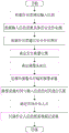
(1)非线性拟合标定法,图3为非线性拟合标定法流程图;(1) nonlinear fitting calibration method, Fig. 3 is a flowchart of nonlinear fitting calibration method;
步骤一、在离线的情况下,将每个摄像头获取初始图片,传递给图像处理装置;
步骤二、图像处理装置中的图像处理软件对图片内的有效区域进行透镜误差和非线性透镜畸变的校正即图片预处理;
步骤三、图像处理装置中的图像处理软件在每个摄像头获取的初始图片中的有效区域内铺设标准网格,网格的疏密程度由样本训练时采样点的多少决定,根据用户的具体要求可进行调节;Step 3. The image processing software in the image processing device lays a standard grid in the effective area of the initial picture acquired by each camera. The density of the grid is determined by the number of sampling points during sample training. According to the specific requirements of the user Can be adjusted;
步骤四、图像处理软件会在畸变校正后的初始图片标准网格内进行采点即采集训练样本;Step 4. The image processing software will collect points in the standard grid of the original image after distortion correction, that is, collect training samples;
步骤五、基于非线性拟合标定法对采集的样本进行训练,使像素坐标与世界坐标形成映射;Step 5, based on the nonlinear fitting calibration method, the collected samples are trained, so that the pixel coordinates and the world coordinates are mapped;
进一步,非线性拟合标定公式如下:Further, the nonlinear fitting calibration formula is as follows:

其中Xi和Yi为训练样本的世界坐标,xi和yi为训练样本的像素坐标i∈(1,n+1)。通过样本训练求解方程,确定拟合系数aj和bj其中j∈(0,n),通过最小二乘法修正拟合系数aj,即误差平法和最小。公式如下:Where Xi and Yi are the world coordinates of the training samples, and xi and yi are the pixel coordinates i∈(1,n+1) of the training samples. Solve the equation through sample training, determine the fitting coefficients aj and bj where j∈(0,n), and correct the fitting coefficient aj by the least square method, that is, the error square method and the minimum. The formula is as follows:

同理修正拟合系数bj,确定拟合系数aj和bj其中j∈(0,n),实现像素坐标与世界坐标之间的映射;In the same way, modify the fitting coefficient bj, determine the fitting coefficients aj and bj where j∈(0,n), and realize the mapping between pixel coordinates and world coordinates;
步骤六、将每个图片的训练结果即参数Origin、X Axis Point和拟合系数保存在图像处理软件中;Step 6, save the training result of each picture, i.e. parameter Origin, X Axis Point and fitting coefficient in the image processing software;
进一步,参数Origin为训练后的原点坐标,参数X Axis Point为训练后的x轴上一点坐标;保存参数的目的在于:使Origin的坐标与标准网格原点(默认左上采样点为原点)重合,使x轴与标准网格的水平方向重合,在默认偏差角度为零度的情况下,y轴是通过已重合的x轴间接确定的;Further, the parameter Origin is the coordinates of the origin after training, and the parameter X Axis Point is the coordinates of a point on the x-axis after training; the purpose of saving the parameters is to make the coordinates of Origin coincide with the origin of the standard grid (the default upper left sampling point is the origin), Make the x-axis coincide with the horizontal direction of the standard grid. When the default deviation angle is zero degrees, the y-axis is determined indirectly through the coincident x-axis;
步骤七、按照实际世界坐标将所有标定区域的坐标进行拼接,即构建整个场区的平面俯视图,Step 7. According to the actual world coordinates, the coordinates of all the calibration areas are stitched together, that is, the plane top view of the entire field area is constructed.
进一步,图片实际坐标=图片训练后坐标+相对世界坐标;Further, the actual coordinates of the picture = the coordinates after training of the picture + the relative world coordinates;
其中,相对世界坐标,默认以场区的左上监控区域为基准,相对世界坐标为该区域的右下采样点坐标;Among them, the relative world coordinates are based on the upper left monitoring area of the site by default, and the relative world coordinates are the lower right sampling point coordinates of the area;
在标定完成的基础上,如图4所示,为本发明基于非线性拟合标定法建立的场区俯视图,根据一个简单的实例阐述区域拼接和场区平面俯视图建立过程。On the basis of the calibration, as shown in Figure 4, it is the top view of the field established based on the nonlinear fitting calibration method of the present invention. According to a simple example, the process of area splicing and the establishment of the top view of the field is explained.
本实例以机位(1,1)区域为基准,其中,机位(1,1)区域的左上点的世界坐标为原点,右下点的世界坐标为(10,10),单位为M;而标定完成的机位(2,2)区域的左上点的世界坐标也是(0,0),右下点的世界坐标为(10,10);但机位(2,2)区域的左上点的实际世界坐标(10,10),右下点的实际世界坐标为(20,20)。This example is based on the camera position (1,1) area, where the world coordinates of the upper left point of the camera position (1,1) area is the origin, and the world coordinates of the lower right point are (10,10), and the unit is M; The world coordinates of the upper left point of the calibrated position (2,2) area are also (0,0), and the world coordinates of the lower right point are (10,10); but the upper left point of the position (2,2) area The actual world coordinates of (10,10), and the actual world coordinates of the lower right point are (20,20).
所以在机位(2,2)区域的原点上加上相对于基准区域机位(1,1)的右下点世界坐标(10,10),便可构成机位(2,2)区域的实际世界坐标,即实际世界坐标等于训练后的坐标加相对世界坐标。同理机位(2,2)区域内所有的点的实际世界坐标都可以通过这种方式求得。Therefore, adding the world coordinates (10,10) of the lower right point relative to the reference area (1,1) to the origin of the camera position (2,2) area can constitute the camera position (2,2) area The actual world coordinates, that is, the actual world coordinates are equal to the trained coordinates plus the relative world coordinates. Similarly, the actual world coordinates of all points in the camera position (2,2) area can be obtained in this way.
通过这种方法就可以将所有标定完成的n*m-1个区域的坐标进行拼接,构成了整个场区世界坐标体系,根据具体的显示窗口大小调节缩放因子便可完成场区俯视图的建立。Through this method, the coordinates of all calibrated n*m-1 areas can be spliced to form the world coordinate system of the entire field area, and the establishment of the top view of the field area can be completed by adjusting the zoom factor according to the specific display window size.
步骤八、每个图片完成标定后,即可进行图片有效区域的拼接,最终形成整个场区的监控俯视图,监控视频中作业人员的位置信息可视为俯视图中移动点的坐标信息;Step 8. After each picture is calibrated, the effective area of the picture can be stitched together, and finally a monitoring overhead view of the entire field is formed. The position information of the operator in the monitoring video can be regarded as the coordinate information of the moving point in the overhead view;
步骤九、作业人员的标定,图像采集装置实时采集图像信息,图像处理软件对采集到的图像信息进行处理,并根据上述方法对作业人员进行在线标定;Step 9, the calibration of the operator, the image acquisition device collects image information in real time, the image processing software processes the collected image information, and performs online calibration of the operator according to the above method;
进一步,作业人员的标定具体为:首先将采集图片进行灰度处理,然后利用背景差除法对图片进行相减,再对相减后的图片进行二值化处理,最后选取二值化图片中的最低点像素坐标作为人员的像素坐标。利用上述标定方法对人员进行在线标定,得到作业人员的世界坐标,并反映在监控俯视图上,实现了作业人员的准确定位。Further, the calibration of the operator is specifically as follows: firstly, grayscale processing is performed on the collected pictures, and then the pictures are subtracted by the background subtraction method, and then the subtracted pictures are binarized, and finally the binarized pictures are selected. The pixel coordinates of the lowest point are used as the pixel coordinates of the person. Using the above calibration method to calibrate the personnel online, the world coordinates of the operators are obtained, and reflected on the monitoring top view, realizing the accurate positioning of the operators.
(2)快速检索方法,图5所示为本发明的快速检索方法流程图;(2) quick retrieval method, shown in Figure 5 is the quick retrieval method flowchart of the present invention;
步骤一、根据作业票确定输入信息,输入信息是可在视频监控装置中进行修改的和存储的表格;
进一步,输入信息表格中包括:管理人员姓名,设备名称,设备型号,作业时间,作业人员姓名及备注等信息;Further, the input information form includes information such as the name of the manager, the name of the equipment, the model of the equipment, the operating time, the name of the operator, and notes;
步骤二、根据输入信息设置具体的安全作业图,实现视频监控装置中操作系统的区域规划功能;
进一步,区域规划的目的在于为报警条件提供实际坐标参考。监控俯视图是管理人员在已完成畸变校正和标定训练的初始图片上根据作业票中设备和区域的实际位置规定的,图中包括规范路径,作业区域和危险区域;Further, the purpose of area planning is to provide actual coordinate references for alarm conditions. The monitoring top view is specified by the management personnel on the initial picture that has completed the distortion correction and calibration training according to the actual location of the equipment and areas in the job ticket. The picture includes the standardized path, the operating area and the dangerous area;
步骤三、根据不同的作业票建立安全作业图库,管理人员可在视频监控装置中操作系统进行库的修改和存储操作;Step 3. Establish a safe job library according to different job tickets, and the management personnel can modify and store the library in the operating system of the video monitoring device;
进一步,安全作业图库为每一张作业票设置安全作业图的集合;Further, the safety operation gallery sets a collection of safety operation diagrams for each operation ticket;
具体的,区域规划的部分如图4所示,以整个场区中的第(i,j)区域为例阐述区域规划的工作原理。图4阴影正方形表示第(i,j)区域的安全作业图,其中,设备所在的棋盘格矩形为依据设备世界坐标设定的危险区域,设备所在的黑色矩形为根据输入信息设置的工作区域,除两个矩形外的四个白色区域为规范路径,具体序号1的规范路径为管理人员根据作业票输入信息为作业人员开放的规范路径,若作业人员行走于除序号1的规划路径中,系统则将其行为视为二级报警。即作业人员只能通过规范路径到达工作区域,且作业人员只能在工作区域内作业;若作业人员误入危险区域,或未经开通的规范路径进入工作区域,则企业的人员行为安全监控系统将会进行报警并记录报警信息。Specifically, the part of the regional planning is shown in FIG. 4 , and the working principle of the regional planning is described by taking the (i, j)th region in the entire site as an example. The shaded square in Figure 4 represents the safety operation map of the (i, j) area, where the checkerboard rectangle where the equipment is located is the dangerous area set according to the world coordinates of the equipment, and the black rectangle where the equipment is located is the working area set according to the input information. The four white areas except for the two rectangles are standard paths. Specifically, the standard path with
这里将根据报警分为非法入侵和违规问题两个类型:a类报警信息视为一级报警,b类报警信息视为二级报警。a.非法入侵是指不在工作时间内和没有从规范路径进入整个场区监控区域内的人员行为,将会进行报警,并记录该人员的一切行为。b.违规问题包括在工作时间内非作业人员进入监控区域和作业人员存在不正规行为两种情况。Here, according to the alarm, it is divided into two types: illegal intrusion and violation of regulations: type a alarm information is regarded as a first-level alarm, and type b alarm information is regarded as a second-level alarm. a. Illegal intrusion refers to the behavior of personnel who do not enter the monitoring area of the entire site during working hours and from the specified path. The alarm will be issued and all behaviors of the personnel will be recorded. b. Violations include non-operating personnel entering the monitoring area during working hours and irregular behavior of operating personnel.
具体的,非作业人员(即将没有录入输入信息的人员视为非作业人员)从规范路径进入监控区域时,系统将会进行报警并记录非作业人员的行为信息;作业人员存在没有按照开放的规范路径到达工作区域、进入了危险区域、完成操作时存在问题,企业的人员行为安全监控系统将会进行报警,并记录下库房工作人员的行为信息。Specifically, when a non-operator (that is, a person who has not entered the input information is regarded as a non-operator) enters the monitoring area from a standardized path, the system will alarm and record the behavior information of the non-operator; If the path reaches the working area, enters the dangerous area, or there is a problem when completing the operation, the enterprise's personnel behavior safety monitoring system will alarm and record the behavior information of the warehouse staff.
步骤四、针对报警信息(报警信息即输出报警装置的报警信号、视频信息、违章日志等),确定放生报警区域;Step 4, for the alarm information (the alarm information is the alarm signal, video information, violation log, etc. of the output alarm device), determine the release alarm area;
步骤五、根据发生报警区域,确定摄像头机位,摄像头机位即摄像头所处监控区域位置;Step 5, according to the area where the alarm occurs, determine the position of the camera, which is the position of the monitoring area where the camera is located;
步骤六、根据摄像头机位查询该摄像头存储的报警信息(即违规日志和记录视频);Step 6. Query the alarm information stored by the camera according to the camera position (that is, the violation log and recorded video);
步骤七、确定报警时间,即将录像的时间信息与作业票输入信息中的时间进行匹配,并同作业票输入信息进行二次核对;Step 7, determine the alarm time, match the time information of the video recording with the time in the input information of the job ticket, and carry out secondary check with the input information of the job ticket;
步骤八、根据已确定的作业票信息,确定具体作业人员;Step 8. Determine the specific operator according to the determined job ticket information;
步骤九、根据具体作业人员的作业票信息,确定其工作路径(即作业人员现场操作时管理人员开放的规范路径),从而确定其经过和工作的监控区域,回调整个视频链,视频链即多个摄像头采集存储的视频信息,实现智能监控系统的快速检索功能。Step 9. According to the job ticket information of specific operators, determine their work path (that is, the standardized path opened by managers when operators operate on site), so as to determine the monitoring area where they pass and work, and call back the entire video chain. The video chain is multiple A camera collects and stores video information to realize the fast retrieval function of the intelligent monitoring system.
以上实施例在以本发明技术方案为前提下进行实施,给出了详细的实施方式和具体的操作过程,但本发明的保护范围不限于上述的实施例。上述实施例中所用方法如无特别说明均为常规方法。The above embodiments are implemented on the premise of the technical solutions of the present invention, and detailed implementation methods and specific operation processes are given, but the protection scope of the present invention is not limited to the above embodiments. The methods used in the above examples are conventional methods unless otherwise specified.
Claims (1)

Priority Applications (1)
| Application Number | Priority Date | Filing Date | Title |
|---|---|---|---|
| CN201710040464.9A CN106791700B (en) | 2017-01-20 | 2017-01-20 | Enterprise critical area personnel path safety monitoring system and method |
Applications Claiming Priority (1)
| Application Number | Priority Date | Filing Date | Title |
|---|---|---|---|
| CN201710040464.9A CN106791700B (en) | 2017-01-20 | 2017-01-20 | Enterprise critical area personnel path safety monitoring system and method |
Publications (2)
| Publication Number | Publication Date |
|---|---|
| CN106791700A CN106791700A (en) | 2017-05-31 |
| CN106791700B true CN106791700B (en) | 2023-05-09 |
Family
ID=58944915
Family Applications (1)
| Application Number | Title | Priority Date | Filing Date |
|---|---|---|---|
| CN201710040464.9A Active CN106791700B (en) | 2017-01-20 | 2017-01-20 | Enterprise critical area personnel path safety monitoring system and method |
Country Status (1)
| Country | Link |
|---|---|
| CN (1) | CN106791700B (en) |
Families Citing this family (11)
| Publication number | Priority date | Publication date | Assignee | Title |
|---|---|---|---|---|
| CN108287519B (en) * | 2018-02-05 | 2019-08-23 | 合肥中科离子医学技术装备有限公司 | Logical construction and implementation method for proton therapy equipment safety interlocking |
| CN109753901B (en) * | 2018-12-21 | 2023-03-24 | 上海交通大学 | Indoor pedestrian tracing method and device based on pedestrian recognition, computer equipment and storage medium |
| CN111191631A (en) * | 2020-01-08 | 2020-05-22 | 哈尔滨融智爱科智能科技有限公司 | Video monitoring supervision area multi-device linkage method based on image domain template matching |
| CN112347847A (en) * | 2020-09-27 | 2021-02-09 | 浙江大丰实业股份有限公司 | Automatic positioning system for stage safety monitoring |
| CN114639217A (en) * | 2020-12-16 | 2022-06-17 | 国电南瑞科技股份有限公司 | Substation indoor area protection and alarm system based on laser radar and working method thereof |
| CN115477211B (en) * | 2021-06-15 | 2023-10-27 | 中移(成都)信息通信科技有限公司 | Elevator stopping method, device, equipment and storage medium |
| CN116310062A (en) * | 2021-12-08 | 2023-06-23 | 中国电信国际有限公司 | Three-dimensional scene construction method and device, storage medium and electronic equipment |
| CN114862973B (en) * | 2022-07-11 | 2022-09-16 | 中铁电气化局集团有限公司 | Space positioning method, device and equipment based on fixed point location and storage medium |
| CN115314685A (en) * | 2022-10-11 | 2022-11-08 | 杭州宇链科技有限公司 | AI video structured analysis-based hazardous chemical substance availability management system and method |
| CN115909188A (en) * | 2022-10-13 | 2023-04-04 | 南通阳鸿石化储运有限公司 | A whole-process management and control application technology of loading platform |
| CN115684637B (en) * | 2022-12-30 | 2023-03-17 | 南京理工大学 | Highway vehicle speed measuring method and device based on roadside monocular camera calibration |
Citations (4)
| Publication number | Priority date | Publication date | Assignee | Title |
|---|---|---|---|---|
| CN101951502A (en) * | 2010-10-19 | 2011-01-19 | 北京硅盾安全技术有限公司 | Three-dimensional intelligent video monitoring method |
| CN102063718A (en) * | 2010-12-24 | 2011-05-18 | 江南大学 | Field calibration and precision measurement method for spot laser measuring system |
| CN103729712A (en) * | 2013-10-25 | 2014-04-16 | 国家电网公司 | Intelligent security control method of electric power field operating personnel |
| CN104835159A (en) * | 2015-05-07 | 2015-08-12 | 中国科学院长春光学精密机械与物理研究所 | Digital image correction method for continuous variable-focal-length optical imaging system |
Family Cites Families (1)
| Publication number | Priority date | Publication date | Assignee | Title |
|---|---|---|---|---|
| US9159210B2 (en) * | 2012-11-21 | 2015-10-13 | Nettalon Security Systems, Inc. | Method and system for monitoring of friend and foe in a security incident |
-
2017
- 2017-01-20 CN CN201710040464.9A patent/CN106791700B/en active Active
Patent Citations (4)
| Publication number | Priority date | Publication date | Assignee | Title |
|---|---|---|---|---|
| CN101951502A (en) * | 2010-10-19 | 2011-01-19 | 北京硅盾安全技术有限公司 | Three-dimensional intelligent video monitoring method |
| CN102063718A (en) * | 2010-12-24 | 2011-05-18 | 江南大学 | Field calibration and precision measurement method for spot laser measuring system |
| CN103729712A (en) * | 2013-10-25 | 2014-04-16 | 国家电网公司 | Intelligent security control method of electric power field operating personnel |
| CN104835159A (en) * | 2015-05-07 | 2015-08-12 | 中国科学院长春光学精密机械与物理研究所 | Digital image correction method for continuous variable-focal-length optical imaging system |
Non-Patent Citations (1)
| Title |
|---|
| 贾传美.煤矿机电事故影响因素及防范路径研究.《山东工业技术》.2015,全文. * |
Also Published As
| Publication number | Publication date |
|---|---|
| CN106791700A (en) | 2017-05-31 |
Similar Documents
| Publication | Publication Date | Title |
|---|---|---|
| CN106791700B (en) | Enterprise critical area personnel path safety monitoring system and method | |
| CN110795989A (en) | Intelligent safety monitoring system for electric power operation and monitoring method thereof | |
| CN115150589A (en) | Video monitoring operation and maintenance management system for coal mine enterprise | |
| CN110807429A (en) | Construction safety detection method and system based on tiny-YOLOv3 | |
| CN111260325A (en) | Bridge construction progress management system based on BIM | |
| CN111950359A (en) | An intelligent system and method for preventing human error in a nuclear power plant | |
| CN111582073A (en) | Transformer substation violation identification method based on ResNet101 characteristic pyramid | |
| WO2017057780A1 (en) | Data collection device, method, and program for display panel or control panel | |
| CN206620222U (en) | A kind of enterprise's key area personnel path safety monitoring system | |
| CN110543866A (en) | Safety management system and method for capital construction engineering constructors | |
| CN115330129A (en) | Enterprise safety risk early warning analysis method and system | |
| CN114821806A (en) | Method and device for determining behavior of operator, electronic equipment and storage medium | |
| CN118521859A (en) | Industrial robot image processing method based on image fusion | |
| CN115909212A (en) | A real-time early warning method for typical violations in electric power operations | |
| CN115690687A (en) | Safe wearing standard detection system based on deep learning technology | |
| CN114997582A (en) | Early warning method and system for distribution network operation risk and computer equipment | |
| CN118761722A (en) | A BIM-based smart construction site system | |
| CN118035707A (en) | An automatic identification system for construction procedures of traffic engineering tunnels | |
| CN114429677B (en) | A method and system for safety identification and assessment of coal mine scene operation behavior | |
| CN115471911A (en) | A method and system for identifying illegal actions at a power grid operation site | |
| CN115601010A (en) | Artificial intelligence fire control wisdom information management platform | |
| CN119851338A (en) | Machine vision-based method and system for identifying working risk of converter station personnel | |
| CN118470612B (en) | Behavior recognition method and system for safe production workers based on multimodal information fusion | |
| CN117692610B (en) | AR workshop inspection system | |
| CN118171809A (en) | Intelligent construction site safety early warning method |
Legal Events
| Date | Code | Title | Description |
|---|---|---|---|
| PB01 | Publication | ||
| PB01 | Publication | ||
| SE01 | Entry into force of request for substantive examination | ||
| SE01 | Entry into force of request for substantive examination | ||
| GR01 | Patent grant | ||
| GR01 | Patent grant |