CN103808306A - Flat plate type construction geologic visualization rapid catalog method based on windows - Google Patents
Flat plate type construction geologic visualization rapid catalog method based on windows Download PDFInfo
- Publication number
- CN103808306A CN103808306A CN201410039112.8A CN201410039112A CN103808306A CN 103808306 A CN103808306 A CN 103808306A CN 201410039112 A CN201410039112 A CN 201410039112A CN 103808306 A CN103808306 A CN 103808306A
- Authority
- CN
- China
- Prior art keywords
- construction
- reference mark
- catalog
- coordinate
- geologic
- Prior art date
- Legal status (The legal status is an assumption and is not a legal conclusion. Google has not performed a legal analysis and makes no representation as to the accuracy of the status listed.)
- Granted
Links
- 238000010276 construction Methods 0.000 title claims abstract description 63
- 238000000034 method Methods 0.000 title claims abstract description 24
- 238000012800 visualization Methods 0.000 title abstract description 3
- 238000009412 basement excavation Methods 0.000 claims abstract description 34
- 230000023445 activated T cell autonomous cell death Effects 0.000 claims abstract description 18
- 238000013461 design Methods 0.000 claims abstract description 13
- 238000012937 correction Methods 0.000 claims abstract description 7
- 238000012545 processing Methods 0.000 claims abstract description 7
- 230000000007 visual effect Effects 0.000 claims description 10
- 230000015572 biosynthetic process Effects 0.000 claims description 6
- 238000004458 analytical method Methods 0.000 claims description 5
- 230000001915 proofreading effect Effects 0.000 claims description 4
- 238000003325 tomography Methods 0.000 claims description 4
- 238000003780 insertion Methods 0.000 claims description 2
- 230000037431 insertion Effects 0.000 claims description 2
- 238000005259 measurement Methods 0.000 description 7
- 238000005516 engineering process Methods 0.000 description 6
- 238000006243 chemical reaction Methods 0.000 description 3
- 238000010422 painting Methods 0.000 description 3
- 238000011161 development Methods 0.000 description 2
- 238000010586 diagram Methods 0.000 description 2
- 239000003973 paint Substances 0.000 description 2
- 230000008569 process Effects 0.000 description 2
- 238000013139 quantization Methods 0.000 description 2
- XLYOFNOQVPJJNP-UHFFFAOYSA-N water Substances O XLYOFNOQVPJJNP-UHFFFAOYSA-N 0.000 description 2
- 238000013459 approach Methods 0.000 description 1
- 230000009286 beneficial effect Effects 0.000 description 1
- 230000008901 benefit Effects 0.000 description 1
- 230000008878 coupling Effects 0.000 description 1
- 238000010168 coupling process Methods 0.000 description 1
- 238000005859 coupling reaction Methods 0.000 description 1
- 230000007547 defect Effects 0.000 description 1
- 230000007613 environmental effect Effects 0.000 description 1
- 238000009432 framing Methods 0.000 description 1
- 230000006872 improvement Effects 0.000 description 1
- 238000011835 investigation Methods 0.000 description 1
- 238000013507 mapping Methods 0.000 description 1
- 238000004321 preservation Methods 0.000 description 1
- 238000004451 qualitative analysis Methods 0.000 description 1
- 238000012113 quantitative test Methods 0.000 description 1
- 239000011435 rock Substances 0.000 description 1
- 230000009466 transformation Effects 0.000 description 1
Images


Classifications
-
- G—PHYSICS
- G01—MEASURING; TESTING
- G01C—MEASURING DISTANCES, LEVELS OR BEARINGS; SURVEYING; NAVIGATION; GYROSCOPIC INSTRUMENTS; PHOTOGRAMMETRY OR VIDEOGRAMMETRY
- G01C11/00—Photogrammetry or videogrammetry, e.g. stereogrammetry; Photographic surveying
-
- G—PHYSICS
- G01—MEASURING; TESTING
- G01V—GEOPHYSICS; GRAVITATIONAL MEASUREMENTS; DETECTING MASSES OR OBJECTS; TAGS
- G01V8/00—Prospecting or detecting by optical means
- G01V8/02—Prospecting
Landscapes
- Physics & Mathematics (AREA)
- General Physics & Mathematics (AREA)
- Engineering & Computer Science (AREA)
- Life Sciences & Earth Sciences (AREA)
- General Life Sciences & Earth Sciences (AREA)
- Geophysics (AREA)
- Multimedia (AREA)
- Radar, Positioning & Navigation (AREA)
- Remote Sensing (AREA)
- Management, Administration, Business Operations System, And Electronic Commerce (AREA)
Abstract
The invention relates to a flat plate type construction geologic visualization rapid catalog method based on windows. The method comprises the following steps: arranging control points on a construction excavation plane; measuring three-dimensional coordinates of the control point; analyzing according to the control point and a design scheme so as to confirm a construction geologic catalog plane, and establishing a catalog coordinate system; converting the three-dimensional coordinate system of the control point into a catalog coordinate, and drawing a geologic catalog image frame in an ACAD; taking images of the construction excavation plane by using a digital camera; performing geometric correction processing on the taken digital images according to the catalog coordinate of the control point; automatically inserting the corrected images serving as the background of geologic catalog images into the ACAD; and editing and processing the geologic catalog image on site, and performing geologic information digitalization acquisition. By adopting the method, the precision of the geologic catalog image is improved, the construction geologic catalog procedure is optimized, and the working efficiency is improved.
Description
Technical field
The present invention relates to geological exploration techniques field, relate in particular to a kind of visual quick logging method of portable flat panel formula construction geology based on windows operating system.
Background technology
Along with the development of China's water conservancy and hydropower cause, and the propelling of Modern Construction and information system management technology, in big-and-middle-sized Hydraulic and Hydro-Power Engineering process of construction, geology need be made rapid reaction to scene, so that the specialty such as collaborative design, construction is processed some potential special geology problems in time, guarantee engineering safety and normal construction.
It is an indispensable very important content in construction stage geological work that construction geology is edited and recorded, traditional construction geology is edited and recorded work, with the field operation work pattern of " craft+compass+tape measure ", determine the geometric properties such as relative position, development length, thickness, spacing of structural plane by tape measure, the on-the-spot structural plane outline line of sketching on paper; Use geologic compass to obtain structural plane occurrence information, then by the on-the-spot papery map of computer scanning vector quantization.This method need to drop into a large amount of manpowers, expends a large amount of time to complete, and efficiency is lower, and can not reflect intuitively on-the-spot landform, landforms etc., is difficult to guarantee the accuracy of measurement data.In addition, along with construction scale of projects is increasing, side slope is dug higher and higher, a rate of advance is more and more faster, in work progress, excavate, muck haulage, supporting is again often to carry out simultaneously, being therefore difficult to geological personnel provides plenty of time and safe space to carry out detailed on-the-spot geological record, particularly in Excavation of High And Steep Slopes process, scene obtains the rock mass structure information of excavation slope, and difficulty is sizable.In the face of the high gradient slope of Rapid Excavation formation, how to complete fast relevant geological record work, how to reduce on construction impact and the potential safety hazard to staff, how under arduous environmental baseline, to improve construction geology and edit and record efficiency and the precision of work, all need to introduce rapidly and efficiently, and topographic condition is had to the field geological investigation technology of very strong suitability.
At present, though there are a lot of various scheme or imaginations edited and recorded based on digitized video, in conjunction with photography, the means such as picture recording, truly, comprehensively, three-dimensionally record working-yard, but the common photo of taking is a kind of description data, though can be true, comprehensively, three-dimensionally record working-yard, can only qualitative analysis geological phenomenon, cannot quantitative test tectonic structure, can not overcome the shortcoming of ordinary numbers image measurement poor performance, particularly fail to become diagram technology in conjunction with CAD preferably, need to work back and forth at the construction field (site) and between office, fail to realize a comparatively perfect photographic geology log system.
Summary of the invention
The technical problem to be solved in the present invention is for defect of the prior art, a kind of quick visualization site operation geological record method based on windows panel computer is provided, measurement, digital photographing, ACAD are drawn for it and geologic record combines, quick disposable ACAD vector quantization geolograph chart and the on-the-spot disposable typing panel computer of geological information that completes belt construction excavation face striograph at the construction field (site).
The technical solution adopted for the present invention to solve the technical problems is:
The visual quick logging method of flat construction geology based on windows, comprises the following steps:
1) on construction and excavation face, lay reference mark, described reference mark is as geolograph chart frame reference mark;
2) with total station survey reference mark three-dimensional coordinate;
3) determine that according to reference mark and analysis of design scheme construction geology edits and records plane, set up and edit and record coordinate system;
4) adopt engineering geology to edit and record program, reference mark three-dimensional coordinate is automatically scaled and edits and records coordinate, in ACAD, automatically draw geolograph chart frame;
5) with digital camera, the excavation face of laying reference mark is taken, every width image should at least comprise four reference mark, and adjacent image should have overlapping; And comparison film number consecutively;
6) according to the coordinate of editing and recording at reference mark, the digital image photographing is carried out to geometry correction processing;
7), according to the coordinate of editing and recording at reference mark, the image in ACAD after automatic insertion correction is as the background of geolograph chart;
8) on-the-spot editing and processing construction geology is edited and recorded figure and is carried out geological information digital collection.
Press such scheme, in described step 3), the method that coordinate system is edited and recorded in foundation is: according to design proposal and construction and excavation situation, adopt engineering geology to edit and record program, analysis is found out three suitable points and is determined that construction geology edits and records plane, edits and records coordinate system using this plane as XOY face; Face this face, using the lower-left point in three points as initial point; Intersection with this plane and surface level is made X-axis, to the right for just, Y-axis along the upper point direction in three points for just.
Press such scheme, described step 4) in, the three-dimensional coordinate at reference mark is scaled to be edited and recorded after coordinate, adopts construction geology to edit and record program, and in ACAD, automatic marking reference mark line are drawn geolograph chart frame.
Press such scheme, described step 7) in, adopt construction geology to edit and record program, the image after proofreading and correct is inserted in geolograph chart automatically after editing and recording coordinate matching.
Press such scheme, described step 8) in, at the scene, the concrete steps that construction geology is edited and recorded are: on panel computer, open ACAD software, figure frame is edited and recorded in generation, insert the digital image of construction and excavation face as a setting, directly sketch, mark the geological informations such as formation lithology, tomography, crack, weak intercalated layer, unfavorable structural plane combination block; Open construction geology again and edit and record program, the geologic description information that typing is relevant, forms the geolograph chart that comprises construction and excavation face image information.
Press such scheme, in described step 5), take step-length according to the size of construction and excavation face and shooting precision set.
Press such scheme, in described step 5), while shooting by breadth with digital camera, digital camera lens keeps vertical, shooting point distance construction excavation face 5m with excavation face.
The present invention be a kind of fast, efficient, accurately, be convenient to the geological record new technology of result's management, information inquiry.With respect to prior art, the beneficial effect that the present invention produces is:
1. adopt the inventive method, by the Portable tablet personal computer based on windows operating system, can carry out at the construction field (site) geological information digital collection, disposable generating digital geolograph chart, greatly improve work efficiency, overcome traditional approach and need to repeatedly come and go office and draw and edit and record figure, shortcoming that cannot disposable generating digital geolograph chart.
2. the present invention determines that according to construction and excavation situation and design proposal construction geology edits and records plane, coordinate system is edited and recorded in foundation, in ACAD, automatically draw geolograph chart frame, automatically insert the digital photograph of the construction and excavation face after proofreading and correct, directly sketch, mark the geological informations such as formation lithology, tomography, crack, unfavorable structural plane, remove need to trace designs the again step of sweep vector of manual mapping from papery, greatly improved the precision of geolograph chart.
3. the present invention carries out geometry correction according to the coordinate of editing and recording at reference mark to the digital photograph of taking, and in proportion and edit and record coordinate and be automatically inserted in ACAD figure; Changed traditional photomosaic mode by coupling identical point, precision is higher, speed is faster.
Accompanying drawing explanation
Below in conjunction with drawings and Examples, the invention will be further described, in accompanying drawing:
Fig. 1 is the flow chart of steps of one embodiment of the invention;
Fig. 2 is that the construction geology of one embodiment of the invention is edited and recorded figure.
Embodiment
In order to make object of the present invention, technical scheme and advantage clearer, below in conjunction with embodiment, the present invention is further elaborated.Should be appreciated that specific embodiment described herein, only in order to explain the present invention, is not intended to limit the present invention.
Further illustrate the present invention below in conjunction with drawings and Examples.
As shown in Figure 1, a kind of Construction for Hydroelectric Project geological record method, mainly comprises the following steps:
Operation is prepared:
Equipment and equipment are prepared: flat-plate special computer; Digital camera (17mm wide-angle lens) and tripod; Total powerstation; Air painting equipment;
1) on panel computer, open ACAD software, will design excavation face data input panel computer, on construction and excavation face, lay reference mark;
2) adopt air pressure gun and clear water to rinse construction and excavation face well;
3) take step-length according to the size of excavation face and shooting precision set, generally adopt 7 × 12m framing, adopt air painting equipment to every width excavation face (every width image taking scope) mark four measuring identification point, each identification point is numbered.
Measure and digital filming part:
4) with total powerstation, paint is indicated to point and carry out three-dimensional coordinate measurement record, measurement point numbering standard is also unique;
5) breadth that mark paint is put is taken according to the order of sequence by breadth with digital camera, every width image of taking should cover four painting sign points, image form is greater than divided rectangle breadth, before and after adjacent each image, be mutually connected by gauge point up and down, camera lens keeps vertical, shooting point distance construction excavation face 5m with excavation face;
6) photo is pressed breadth name, and name is unique, and the gauge point on every photos is consistent with measurement point numbering.
Coordinate transformation and coordinate points generating identification point distribution schematic diagram
7) with usb line, total powerstation is connected with panel computer, measuring point coordinate file is input to panel computer; As required, choose four measuring identification point for design frame point at all measurement identification points, as whole reference surface reference mark of editing and recording face, obtain the design frame of the face of editing and recording;
8) determine that according to reference mark and analysis of design scheme construction geology edits and records plane, set up and edit and record coordinate system; The process that coordinate system is edited and recorded in foundation is: according to design proposal and construction and excavation situation, adopt engineering geology to edit and record program, analyze and find out three suitable points and determine that construction geology edits and records plane, edit and record coordinate system using this plane as XOY face; Face this face, using the lower-left point in three points as initial point; Intersection with this plane and surface level is made X-axis, to the right for just, Y-axis along the upper point direction in three points for just.
9) adopt engineering geology to edit and record program, reference mark three-dimensional coordinate is automatically scaled and edits and records coordinate, in ACAD, automatically draw geolograph chart frame; Following table is the coordinate conversion table that part is measured identification point:
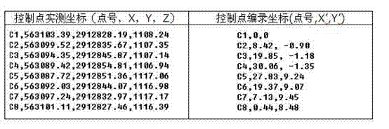
Image rectification and splicing
10) digital camera is connected with panel computer with data line, and the digital photograph of taking is input to panel computer by data line;
11), according to sheet designation and reference mark numbering, corresponding numbering name is carried out at the reference mark on comparison film and photo;
12) adopt VPstudio software to carry out geometry correction processing preservation to individual digital photograph.Adopt self-editing construction geology to edit and record program, automatically generate the text corresponding with digital photograph, text records the lower left corner of this digital photograph and edits and records coordinate and the ratio with actual size thereof; By the digital photograph after proofreading and correct automatically in proportion and edit and record coordinate and be inserted in ACAD, as the background of geolograph chart, as shown in Figure 2.
Geological record:
13) on panel computer, open self-editing geological record program, by geologic contents such as standard format typing comprehensive descriptions;
14) on panel computer, open ACAD software, generate and edit and record figure frame, insert the digital image of construction and excavation face as a setting, directly sketch, mark the geological informations such as formation lithology, tomography, crack, weak intercalated layer, unfavorable structural plane combination block; Again its occurrence, proterties, scale etc. are measured and describe direct typing flat-plate special computer, the geolograph chart that disposable direct formation comprises construction and excavation face image information.
Should be understood that, for those of ordinary skills, can be improved according to the above description or convert, and all these improvement and conversion all should belong to the protection domain of claims of the present invention.
Claims (7)
1. the visual quick logging method of flat site operation geology based on windows, is characterized in that, comprises the following steps:
1) on construction and excavation face, lay reference mark, described reference mark is as geolograph chart frame reference mark;
2) with total station survey reference mark three-dimensional coordinate;
3) determine that according to reference mark and analysis of design scheme construction geology edits and records plane, set up and edit and record coordinate system;
4) adopt engineering geology to edit and record program, reference mark three-dimensional coordinate is automatically scaled and edits and records coordinate, in ACAD, automatically draw geolograph chart frame;
5) with digital camera, the excavation face of laying reference mark is taken, every width image should at least comprise four reference mark, and adjacent image should have overlapping; And comparison film number consecutively;
6), according to the coordinate of editing and recording at reference mark, adopt VPstudio software to carry out geometry correction processing to the digital image photographing;
7), according to the coordinate of editing and recording at reference mark, the image in ACAD after automatic insertion correction is as the background of geolograph chart;
8) on-the-spot editing and processing construction geology is edited and recorded figure and is carried out geological information digital collection.
2. visual quick logging method according to claim 1, it is characterized in that, in described step 3), the method that coordinate system is edited and recorded in foundation is: according to design proposal and construction and excavation situation, adopt self-editing engineering geology to edit and record program, analysis is found out three suitable points and is determined that construction geology edits and records plane, edits and records coordinate system using this plane as XOY face; Face this face, using the lower-left point in three points as initial point; Intersection with this plane and surface level is made X-axis, to the right for just, Y-axis along the upper point direction in three points for just.
3. visual quick logging method according to claim 1, it is characterized in that described step 4) in, the three-dimensional coordinate at reference mark is scaled to be edited and recorded after coordinate, adopt construction geology to edit and record program, in ACAD, automatic marking reference mark line are drawn geolograph chart frame.
4. visual quick logging method according to claim 1, is characterized in that described step 7) in, adopt construction geology to edit and record program, the image after proofreading and correct is inserted in geolograph chart by editing and recording coordinate automatically.
5. visual quick logging method according to claim 1, it is characterized in that, described step 8) in, at the scene, the concrete steps that construction geology is edited and recorded are: on panel computer, open ACAD software, figure frame is edited and recorded in generation, inserts the digital image of construction and excavation face as a setting, directly sketches, marks the geological informations such as formation lithology, tomography, crack, weak intercalated layer, unfavorable structural plane combination block; Open construction geology again and edit and record program, the geologic description information that typing is relevant, forms the geolograph chart that comprises construction and excavation face image information.
6. visual quick logging method according to claim 1, is characterized in that, in described step 5), takes step-length according to the size of construction and excavation face and shooting precision set.
7. visual quick logging method according to claim 1, is characterized in that, in described step 5), while shooting by breadth with digital camera, digital camera lens keeps vertical, shooting point distance construction excavation face 5m with excavation face.
Priority Applications (1)
| Application Number | Priority Date | Filing Date | Title |
|---|---|---|---|
| CN201410039112.8A CN103808306B (en) | 2014-01-27 | 2014-01-27 | Flat plate type construction geologic visualization rapid catalog method based on windows |
Applications Claiming Priority (1)
| Application Number | Priority Date | Filing Date | Title |
|---|---|---|---|
| CN201410039112.8A CN103808306B (en) | 2014-01-27 | 2014-01-27 | Flat plate type construction geologic visualization rapid catalog method based on windows |
Publications (2)
| Publication Number | Publication Date |
|---|---|
| CN103808306A true CN103808306A (en) | 2014-05-21 |
| CN103808306B CN103808306B (en) | 2015-04-08 |
Family
ID=50705420
Family Applications (1)
| Application Number | Title | Priority Date | Filing Date |
|---|---|---|---|
| CN201410039112.8A Active CN103808306B (en) | 2014-01-27 | 2014-01-27 | Flat plate type construction geologic visualization rapid catalog method based on windows |
Country Status (1)
| Country | Link |
|---|---|
| CN (1) | CN103808306B (en) |
Cited By (5)
| Publication number | Priority date | Publication date | Assignee | Title |
|---|---|---|---|---|
| CN107816952A (en) * | 2017-10-27 | 2018-03-20 | 长江三峡勘测研究院有限公司(武汉) | A kind of method that successively excavation project obtains overall 3-dimensional image |
| CN109236275A (en) * | 2018-09-26 | 2019-01-18 | 中国电建集团成都勘测设计研究院有限公司 | Decomposition method based on borehole television photography structural plane occurrence |
| CN110443878A (en) * | 2019-08-16 | 2019-11-12 | 中国电建集团成都勘测设计研究院有限公司 | Rock mass direct shear test test specimen shear surface waviness edits and records method |
| CN113706618A (en) * | 2021-08-31 | 2021-11-26 | 中煤科工集团重庆研究院有限公司 | Geological image compiling and recording method and system for mine photogrammetry |
| CN120012252A (en) * | 2025-04-22 | 2025-05-16 | 中国电建集团西北勘测设计研究院有限公司 | A system and method for compiling geological information of underground powerhouse caverns |
Citations (5)
| Publication number | Priority date | Publication date | Assignee | Title |
|---|---|---|---|---|
| CN1477567A (en) * | 2003-07-11 | 2004-02-25 | 中国地质大学(武汉) | Computer Aided Geological Survey System Based on Portable Computer |
| US6895356B2 (en) * | 2003-08-14 | 2005-05-17 | Rubicon Digital Mapping Associates | Integrated laser mapping tablet and method of use |
| CN101629821A (en) * | 2009-08-07 | 2010-01-20 | 长江三峡勘测研究院有限公司(武汉) | Digital image acquisition and processing method for small-section underground room |
| CN101709964A (en) * | 2009-12-04 | 2010-05-19 | 长江三峡勘测研究院有限公司(武汉) | Large-scale grotto instrument-measuring imaging visual geological recording method |
| CN103438864A (en) * | 2013-08-07 | 2013-12-11 | 长江勘测规划设计研究有限责任公司 | Real-time digital geological record system for engineering side slope |
-
2014
- 2014-01-27 CN CN201410039112.8A patent/CN103808306B/en active Active
Patent Citations (5)
| Publication number | Priority date | Publication date | Assignee | Title |
|---|---|---|---|---|
| CN1477567A (en) * | 2003-07-11 | 2004-02-25 | 中国地质大学(武汉) | Computer Aided Geological Survey System Based on Portable Computer |
| US6895356B2 (en) * | 2003-08-14 | 2005-05-17 | Rubicon Digital Mapping Associates | Integrated laser mapping tablet and method of use |
| CN101629821A (en) * | 2009-08-07 | 2010-01-20 | 长江三峡勘测研究院有限公司(武汉) | Digital image acquisition and processing method for small-section underground room |
| CN101709964A (en) * | 2009-12-04 | 2010-05-19 | 长江三峡勘测研究院有限公司(武汉) | Large-scale grotto instrument-measuring imaging visual geological recording method |
| CN103438864A (en) * | 2013-08-07 | 2013-12-11 | 长江勘测规划设计研究有限责任公司 | Real-time digital geological record system for engineering side slope |
Cited By (8)
| Publication number | Priority date | Publication date | Assignee | Title |
|---|---|---|---|---|
| CN107816952A (en) * | 2017-10-27 | 2018-03-20 | 长江三峡勘测研究院有限公司(武汉) | A kind of method that successively excavation project obtains overall 3-dimensional image |
| CN107816952B (en) * | 2017-10-27 | 2023-11-17 | 长江三峡勘测研究院有限公司(武汉) | Method for obtaining whole three-dimensional image by layer-by-layer excavation engineering |
| CN109236275A (en) * | 2018-09-26 | 2019-01-18 | 中国电建集团成都勘测设计研究院有限公司 | Decomposition method based on borehole television photography structural plane occurrence |
| CN110443878A (en) * | 2019-08-16 | 2019-11-12 | 中国电建集团成都勘测设计研究院有限公司 | Rock mass direct shear test test specimen shear surface waviness edits and records method |
| CN113706618A (en) * | 2021-08-31 | 2021-11-26 | 中煤科工集团重庆研究院有限公司 | Geological image compiling and recording method and system for mine photogrammetry |
| CN113706618B (en) * | 2021-08-31 | 2025-02-11 | 中煤科工集团重庆研究院有限公司 | Mine photogrammetry geological image recording method and system |
| CN120012252A (en) * | 2025-04-22 | 2025-05-16 | 中国电建集团西北勘测设计研究院有限公司 | A system and method for compiling geological information of underground powerhouse caverns |
| CN120012252B (en) * | 2025-04-22 | 2025-07-18 | 中国电建集团西北勘测设计研究院有限公司 | Underground factory building chamber geological information recording system and method |
Also Published As
| Publication number | Publication date |
|---|---|
| CN103808306B (en) | 2015-04-08 |
Similar Documents
| Publication | Publication Date | Title |
|---|---|---|
| CN101709964B (en) | Large-scale grotto instrument-measuring imaging visual geological recording method | |
| CN103322911B (en) | A kind of purpose-built elevation drawing mapping method based on image | |
| CN103412967B (en) | The application process of field geology information acquisition system, acquisition method and acquisition system | |
| CN104679822B (en) | A kind of geographical national conditions fieldwork measurement method | |
| CN106846478A (en) | Edit and record charting system in water power hydraulic engineering geology three-dimensional live field | |
| CN103438864B (en) | Engineering slope real-time digital geological record system | |
| CN103808306A (en) | Flat plate type construction geologic visualization rapid catalog method based on windows | |
| CN103335606A (en) | Three dimensional laser scanning and surveying and mapping method | |
| CN105716583B (en) | A kind of exploration adit geological record base map generation method based on parallel photography | |
| CN106875434A (en) | A kind of light section prospecting adit geological record method based on 3 D laser scanning | |
| CN103808307B (en) | Portable tablet type engineering geological surveying and mapping working method based on windows | |
| CN100450152C (en) | Geological digital image recording system and its application method | |
| CN103093388A (en) | Photography geological record system based on tunnel face | |
| CN116465373A (en) | A Geological Recording Method for Underground Excavation Engineering Rock Cavities | |
| CN106875485B (en) | Method for establishing site three-dimensional coordinate system for geological construction record of hydroelectric engineering | |
| CN106846477A (en) | A kind of geology mark interpretation modeling method for editing and recording field geology image | |
| CN103245331B (en) | Control method of large-scale aerial survey indoor and outdoor integrated system | |
| CN108469224A (en) | Pipeline engineering fluting dimension measurement method based on image recognition | |
| CN117934484A (en) | Tunnel face surrounding rock level judging method, equipment and storage medium | |
| CN106403907B (en) | A kind of structural plane charges based on orthography carefully see geological record method | |
| CN105809627B (en) | A kind of geological record method of hydroelectric project underground chamber | |
| JP2009169676A (en) | Sketch map creation and recording support system for exposed strata and exposed rock | |
| CN103759720A (en) | Digital point-pricking method for aerial survey field work | |
| CN113418511B (en) | Digital mapping system and mapping method for water conservancy and hydropower engineering geology | |
| CN106595571A (en) | Underground cavern geological catalog method based on handheld laser range finder |
Legal Events
| Date | Code | Title | Description |
|---|---|---|---|
| C06 | Publication | ||
| PB01 | Publication | ||
| C10 | Entry into substantive examination | ||
| SE01 | Entry into force of request for substantive examination | ||
| C14 | Grant of patent or utility model | ||
| GR01 | Patent grant |