CN102436738B - A drone-based traffic monitoring device - Google Patents
A drone-based traffic monitoring device Download PDFInfo
- Publication number
- CN102436738B CN102436738B CN201110287250.4A CN201110287250A CN102436738B CN 102436738 B CN102436738 B CN 102436738B CN 201110287250 A CN201110287250 A CN 201110287250A CN 102436738 B CN102436738 B CN 102436738B
- Authority
- CN
- China
- Prior art keywords
- traffic
- vehicle
- video
- unmanned aerial
- information
- Prior art date
- Legal status (The legal status is an assumption and is not a legal conclusion. Google has not performed a legal analysis and makes no representation as to the accuracy of the status listed.)
- Expired - Fee Related
Links
Images


Landscapes
- Traffic Control Systems (AREA)
- Image Analysis (AREA)
Abstract
本发明公开了一种基于无人机的交通监测装置,其包括无人机和处理设备,无人机上装设有成像设备、定位设备和传输设备,所述成像设备采集地面交通视频,所述定位设备,确定飞行参数,获得交通视频对应的时空信息,所述传输设备,将成像设备和定位设备所采集的信息传输至处理设备;处理设备结合交通视频及与其一一对应的时空信息计算获得交通信息。本发明还可以根据该交通信息和时空信息,建立与视频文件的关联数据库,实现交通视频快速检索和视频片段定位。
The invention discloses a traffic monitoring device based on an unmanned aerial vehicle, which includes an unmanned aerial vehicle and processing equipment. The unmanned aerial vehicle is equipped with imaging equipment, positioning equipment and transmission equipment. The imaging equipment collects ground traffic video, and the The positioning device determines the flight parameters and obtains the spatio-temporal information corresponding to the traffic video, and the transmission device transmits the information collected by the imaging device and the positioning device to the processing device; the processing device combines the traffic video and its corresponding spatio-temporal information to calculate and obtain Travel information. The present invention can also establish a database associated with video files according to the traffic information and time-space information, so as to realize fast retrieval of traffic videos and positioning of video segments.
Description
技术领域 technical field
本发明属于交通技术领域,涉及交通事件快速响应、交通事件监测和公安及路政系统车辆追踪,尤其是一种基于无人机的交通监测装置。The invention belongs to the technical field of traffic, and relates to rapid response to traffic events, traffic event monitoring, and vehicle tracking in public security and road administration systems, in particular to a traffic monitoring device based on an unmanned aerial vehicle.
背景技术 Background technique
无人驾驶飞机是一种用来观测地表目标或投放对地武器的空中飞行平台,被广泛应用于军事战争,用来进行情报侦察,其可以通过其观测地表目标的功能用来检测交通信息。与传统的交通信息检测设备相比,其特点是部署灵活、单设备监测视野广、成本低,并可采集车辆运行轨迹等微观交通信息,应用前景广阔。Unmanned aircraft is an aerial platform used to observe surface targets or drop ground weapons. It is widely used in military warfare for intelligence reconnaissance. It can be used to detect traffic information through its function of observing surface targets. Compared with traditional traffic information detection equipment, it is characterized by flexible deployment, wide field of vision for single-device monitoring, low cost, and can collect micro-traffic information such as vehicle trajectories. It has broad application prospects.
无人驾驶飞机可通过成像设备采集道路交通视频信息,这些视频信息具有明显的时空属性,且蕴含明确的交通语义。交通语义是指描述出行者交通行为的语言,如车辆跟驰、换道、加速、减速以及交通流的流量、速度和密度参数等描述性参数。如何从海量视频数据中快速查找,符合指定的文本检索条件或与指定车辆图像相似的视频片段,是无人机在交通中应用的关键问题之一。Unmanned aircraft can collect road traffic video information through imaging equipment. These video information have obvious spatio-temporal attributes and contain clear traffic semantics. Traffic semantics refers to the language that describes the traffic behavior of travelers, such as vehicle following, lane changing, acceleration, deceleration, and descriptive parameters such as traffic flow, speed, and density parameters. How to quickly find video clips that meet specified text retrieval conditions or are similar to specified vehicle images from massive video data is one of the key issues in the application of UAVs in traffic.
发明内容 Contents of the invention
本发明的目的在于提供一种基于无人机的交通监测装置,可确定交通信息,并构建数据库,该实现交通视频的海量信息存储和快速检索。The purpose of the present invention is to provide a UAV-based traffic monitoring device, which can determine traffic information and build a database, which can realize massive information storage and fast retrieval of traffic videos.
为达到以上目的,本发明所采用的解决方案是:For achieving above object, the solution that the present invention adopts is:
一种基于无人机的交通监测装置,其包括无人机和处理设备,无人机上装设有成像设备、定位设备和传输设备,所述成像设备采集地面交通视频,所述定位设备,确定飞行参数,获得交通视频对应的时空信息,所述传输设备,将成像设备和定位设备所采集的信息传输至处理设备;处理设备结合交通视频及与其一一对应的时空信息计算获得交通信息。A traffic monitoring device based on an unmanned aerial vehicle, which includes an unmanned aerial vehicle and a processing device. The unmanned aerial vehicle is equipped with imaging equipment, positioning equipment and transmission equipment. The imaging equipment collects ground traffic video, and the positioning equipment determines The flight parameters are used to obtain the spatio-temporal information corresponding to the traffic video. The transmission device transmits the information collected by the imaging device and the positioning device to the processing device;
所述飞行参数包括无人机的经纬度、无人机的倾斜角、翻滚角、方向角和飞行高度。The flight parameters include the latitude and longitude of the UAV, the tilt angle, roll angle, direction angle and flight height of the UAV.
所述处理设备包括车辆位置识别模块和交通语义提取模块,所述车辆位置识别模块通过对采集交通视频的成像设备参数标定,利用图像边缘检测canny算法和图像板块轮廓,确定道路区域;统计道路区域灰度值直方图峰值,作为背景灰度信息,分割图像;通过图像斑块分析,利用车辆的几何形状特征作为模板,检测移动和静止车辆;利用Kanade-Lucas-Tomasi特征跟踪算法,结合K均值聚类,跟踪运动车辆,车辆速度在道路方向值大于指定的阈值时,判定为运动车辆,除去运动车辆,剩余图像斑块为静止车辆;通过透视成像模型的几何关系、相机的焦距和图像主点位置,利用空间几何图形的相似关系计算车辆尺寸;利用成像设备参数将图像坐标转换为世界坐标,车辆图像斑块中心所对应的世界坐标即为车辆实际空间坐标;所述交通语义提取模块根据车辆的实际空间坐标以及每一视频帧所对应的时间和车辆的编号,获取车辆的行驶轨迹,并按照交通工程学的定义统计获取交通量、交通密度和平均速度。The processing device includes a vehicle position identification module and a traffic semantic extraction module, and the vehicle position identification module determines the road area by using the image edge detection canny algorithm and the image plate outline by calibrating the parameters of the imaging device for collecting the traffic video; counting the road area The peak value of the gray value histogram is used as the background gray information to segment the image; through image patch analysis, the geometric shape of the vehicle is used as a template to detect moving and stationary vehicles; the Kanade-Lucas-Tomasi feature tracking algorithm is used, combined with K-means Clustering, tracking moving vehicles, vehicle speed when the road direction value is greater than the specified threshold, it is judged as a moving vehicle, remove the moving vehicle, and the remaining image patches are stationary vehicles; through the geometric relationship of the perspective imaging model, the focal length of the camera and the main image point position, using the similarity relationship of spatial geometry to calculate the vehicle size; using the imaging device parameters to convert the image coordinates into world coordinates, the world coordinates corresponding to the center of the vehicle image patch is the actual space coordinates of the vehicle; the traffic semantic extraction module according to The actual space coordinates of the vehicle, the time corresponding to each video frame and the number of the vehicle are obtained to obtain the vehicle's driving trajectory, and the traffic volume, traffic density and average speed are obtained statistically according to the definition of traffic engineering.
所述成像设备参数包括成像设备内部参数和外部参数,内部参数包括焦距、图像主点位置和五个畸变参数,外部参数包括旋转矩阵R和平移向量T。The imaging device parameters include internal parameters and external parameters of the imaging device, the internal parameters include focal length, image principal point position and five distortion parameters, and the external parameters include rotation matrix R and translation vector T.
所述处理设备还包括交通安全判别模块,根据道路的限速信息,当从视频检测到的车辆速度达到阈值时则认为车辆危险驾驶;检测到静态车辆,若车辆不在路边则认为非常有可能是交通事故;根据车辆的行驶轨迹,判断车辆的方向,如果车辆方向与道路方向不一致则认为是逆向行驶。The processing device also includes a traffic safety discrimination module. According to the speed limit information of the road, when the vehicle speed detected from the video reaches a threshold, it is considered that the vehicle is driving dangerously; if a static vehicle is detected, it is considered very likely if the vehicle is not on the roadside It is a traffic accident; judge the direction of the vehicle according to the driving track of the vehicle, and if the direction of the vehicle is inconsistent with the direction of the road, it is considered to be driving in the reverse direction.
所述处理设备还包括视频检索模块,根据视频对应的交通语义和时空信息,建立交通视频文件与交通语义的关联,构成检索数据库。The processing device also includes a video retrieval module, which establishes the association between traffic video files and traffic semantics according to the traffic semantics and spatio-temporal information corresponding to the video to form a retrieval database.
所述交通视频文件与交通语义的关联,是将描述交通行为的信息记录至对应的数据库,在数据库中建立外键字段,该外键字段使得数据库与视频文件信息表格建立索引关系,完成视频文件交通语义的自动标注。The association between the traffic video file and the traffic semantics is to record the information describing the traffic behavior to the corresponding database, and establish a foreign key field in the database, which makes the database and the video file information table establish an index relationship, and completes the video file Automatic labeling of traffic semantics.
由于采用了上述方案,本发明具有以下特点:利用该方法,用户可快速查找符合条件的交通视频片段及其对应的时空信息,结合人工视频识别,可确认交通事件或进行特定车辆追踪。本发明在交通事件管理和公安及路政系统特定车辆追踪领域有较好的应用前景。Due to the adoption of the above solution, the present invention has the following characteristics: using this method, users can quickly search for qualified traffic video segments and their corresponding spatio-temporal information, combined with manual video recognition, can confirm traffic events or track specific vehicles. The invention has better application prospects in the fields of traffic event management and specific vehicle tracking in public security and road administration systems.
附图说明 Description of drawings
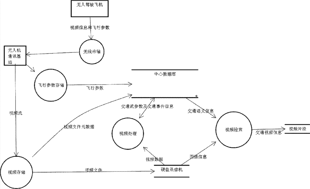
图1是本发明涉及的硬件及其数据流图。Fig. 1 is a diagram of hardware and its data flow involved in the present invention.
图2是基于交通语义的无人机视频检索方法实施流程。Figure 2 is the implementation flow of the UAV video retrieval method based on traffic semantics.
具体实施方式 Detailed ways
以下结合附图所示实施例对本发明作进一步的说明。The present invention will be further described below in conjunction with the embodiments shown in the accompanying drawings.
本发明一种基于无人机的交通监测装置包括无人驾驶飞机(携带成像设备、差分GPS、陀螺仪和信息传输设备)、地面控制站、硬盘录像机和业务主机等,如图1所示成像设备按照预先设置的采样率拍摄检测目标的视频;无人机配置的定位设备如陀螺仪和差分GPS确定飞机的经纬度、飞机的倾斜角、翻滚角和方向角以及飞行高度,还可获得拍摄交通视频时的时间信息;无人机配置的通讯设备将视频数据和无人机飞行参数数据通过无人机与其基站的专用无线通道,将数据传输至无人机基站。在实际工作时,拍摄交通视频时的时间信息也可通过成像设备计时获得。A kind of traffic monitoring device based on unmanned aerial vehicle of the present invention comprises unmanned aerial vehicle (carrying imaging device, differential GPS, gyroscope and information transmission equipment), ground control station, hard disk video recorder and business main frame etc., imaging as shown in Figure 1 The device shoots the video of the detected target according to the preset sampling rate; the positioning equipment configured by the UAV, such as gyroscope and differential GPS, determines the latitude and longitude of the aircraft, the tilt angle, roll angle and direction angle of the aircraft, as well as the flight altitude, and can also obtain the shooting traffic Time information during video; the communication equipment configured by the UAV transmits the video data and UAV flight parameter data to the UAV base station through the dedicated wireless channel between the UAV and its base station. In actual work, the time information when shooting the traffic video can also be obtained through the timing of the imaging device.
本发明的装置进行交通监测的具体实施步骤如图2所示:The concrete implementation steps that device of the present invention carries out traffic monitoring is as shown in Figure 2:
第一步:交通视频采集Step 1: Traffic Video Collection
按照需求规划无人飞机飞行线路和飞行高度,根据天气和光照条件选择合适的视频采集镜头(如适合穿透大雾的镜头或弱光照条件下的镜头),检查无人飞机设备状态,检查无人驾驶飞机、地面控制站、硬盘录像机和业务主机之间的通信链路,执行飞行任务,通过成像设备(相机)获取地面交通视频,通过定位设备获取交通视频所对应的时空信息。Plan the flight route and altitude of the unmanned aircraft according to the needs, select the appropriate video capture lens according to the weather and light conditions (such as the lens suitable for penetrating thick fog or under low light conditions), check the equipment status of the unmanned aircraft, check the The communication link between the manned aircraft, the ground control station, the hard disk video recorder and the business host performs the flight mission, obtains the ground traffic video through the imaging device (camera), and obtains the time-space information corresponding to the traffic video through the positioning device.
第二步:视频文件存储Step 2: Video file storage
设置地面控制站视频存储格式,将无人驾驶飞机采集的视频流转换为指定格式的视频文件并存储至硬盘录像机,同时将视频文件相应的文件信息和无人机飞行参数(包括飞机的经纬度、飞机的倾斜角、翻滚角和方向角和飞行高度)存储至业务主机的MYSQL数据库。Set the video storage format of the ground control station, convert the video stream collected by the drone into a video file of the specified format and store it in the hard disk recorder, and at the same time store the corresponding file information of the video file and the flight parameters of the drone (including the longitude and latitude of the aircraft, The aircraft's tilt angle, roll angle, direction angle and flight altitude) are stored to the MYSQL database of the business host.
第三步:车辆识别与跟踪Step 3: Vehicle Identification and Tracking
通过无人飞机相机参数标定,获取相机内部参数(焦距、图像主点位置和五个畸变参数)和外部参数(旋转矩阵R和平移向量T),然后利用图像边缘检测canny算法和图像板块轮廓,确定道路区域;统计道路区域灰度值直方图峰值,作为背景灰度信息,分割图像;通过图像斑块分析,利用车辆的几何形状特征作为模板,检测移动和静止车辆;利用Kanade-Lucas-Tomasi特征跟踪算法,结合K均值聚类,跟踪运动车辆,车辆速度在道路方向值大于指定的阈值时,判定为运动车辆,并且可以确定车辆的位置信息,除去运动车辆,剩余图像斑块为静止车辆。结合相机参数标定信息、焦距信息、无人机飞行姿态数据(包括经纬度、飞机的倾斜角、翻滚角和方向角和飞行高度),根据空间几何关系,计算确定车辆的尺寸、空间位置。车辆的尺寸可以通过透视成像模型的几何关系、相机的焦距和图像主点位置,利用空间几何图形的相似关系计算(具体计算公式可参照计算机视觉或遥感图像处理教程);利用相机外部参数(相机坐标与世界坐标的转换矩阵R和平移向量T),可以将图像坐标转换为世界坐标,车辆图像斑块中心所对应的世界坐标即为车辆实际空间坐标。Through unmanned aerial vehicle camera parameter calibration, obtain camera internal parameters (focal length, image principal point position and five distortion parameters) and external parameters (rotation matrix R and translation vector T), and then use image edge detection canny algorithm and image plate outline, Determine the road area; count the peak value of the histogram of the gray value of the road area, as the background gray information, and segment the image; through image patch analysis, use the geometric shape characteristics of the vehicle as a template to detect moving and stationary vehicles; use Kanade-Lucas-Tomasi Feature tracking algorithm, combined with K-means clustering, to track moving vehicles. When the vehicle speed is greater than the specified threshold, it is judged as a moving vehicle, and the location information of the vehicle can be determined. After removing the moving vehicles, the remaining image patches are stationary vehicles . Combining camera parameter calibration information, focal length information, UAV flight attitude data (including longitude and latitude, aircraft tilt angle, roll angle and direction angle, and flight height), according to the spatial geometric relationship, calculate and determine the size and spatial position of the vehicle. The size of the vehicle can be calculated through the geometric relationship of the perspective imaging model, the focal length of the camera and the position of the principal point of the image, and the similarity relationship of the spatial geometry (the specific calculation formula can refer to the tutorial of computer vision or remote sensing image processing); using the external parameters of the camera (camera The conversion matrix R and the translation vector T) between coordinates and world coordinates can convert image coordinates into world coordinates, and the world coordinates corresponding to the center of the vehicle image patch are the actual space coordinates of the vehicle.
第四步:视频文件交通语义提取Step 4: Video file traffic semantic extraction
通过第三步(车辆识别与跟踪),可以得到视频中车辆对应的实际空间坐标、每一视频帧所对应的时间和车辆的编号(车辆追踪算法所追踪到的相同车辆在不同视频帧中编号相同)。利用第三步(车辆识别与追踪)所得到的车辆空间及时间信息,按照交通工程学的定义统计交通量(悬停状态,经过检测区域的车辆版块数目)、交通密度(单位长度上车辆图像斑块个数)和平均速度(利用车辆在若干帧的空间位置间隔和从帧数计算的时间间隔计算),可直接计算基本的交通流参数:交通密度、平均速度和交通量。Through the third step (vehicle identification and tracking), the actual space coordinates corresponding to the vehicle in the video, the time corresponding to each video frame and the number of the vehicle can be obtained (the same vehicle tracked by the vehicle tracking algorithm is numbered in different video frames same). Using the vehicle space and time information obtained in the third step (vehicle identification and tracking), according to the definition of traffic engineering, the traffic volume (hovering state, the number of vehicle blocks passing through the detection area), traffic density (vehicle image per unit length number of patches) and average speed (calculated using the spatial position interval of vehicles in several frames and the time interval calculated from the number of frames), the basic traffic flow parameters can be directly calculated: traffic density, average speed and traffic volume.
利用先验知识分析视频对应的交通语义,如超速、低速、车辆抛锚和车辆危险驾驶行为等。车辆的行驶轨迹和方向可由第三步(车辆识别与追踪)直接获得。根据道路的限速信息,当从视频检测到的车辆速度达到阈值时则认为车辆危险驾驶;检测到静态车辆,若车辆不在路边则认为非常有可能是交通事故;根据上述车辆追踪方法追踪的结果,判断车辆的方向,如果车辆方向与道路方向不一致则认为是逆向行驶。Using prior knowledge to analyze the traffic semantics corresponding to the video, such as speeding, low speed, vehicle breakdown and dangerous driving behavior of the vehicle, etc. The trajectory and direction of the vehicle can be obtained directly from the third step (vehicle identification and tracking). According to the speed limit information of the road, when the vehicle speed detected from the video reaches the threshold, the vehicle is considered to be driving dangerously; if a static vehicle is detected, if the vehicle is not on the side of the road, it is considered to be a traffic accident; As a result, the direction of the vehicle is judged, and if the direction of the vehicle does not coincide with the direction of the road, it is considered to be traveling in the wrong direction.
第五步:交通视频文件自动标定Step 5: Automatic calibration of traffic video files
利用第四步所提取的车辆平均速度、交通密度、交通流量,根据车辆速度和所在道路的限速信息判断车辆是否为安全驾驶,根据车辆的行驶方向是否与道路一致,判断车辆是否为逆向行驶,判断车辆速度是否超出限速范围,获得视频对应的交通语义和时空信息,并将这些信息和硬盘录像机的视频文件信息存储到业务主机的MYSQL,建立视频文件与交通语义的关联。关联方法:将这些描述交通行为的信息记录对应的数据表,在数据库表中的建立外键字段,该外键字段使得这个表格与视频文件信息表格建立索引关系,完成视频文件交通语义的自动标注。Using the average vehicle speed, traffic density, and traffic flow extracted in the fourth step, judge whether the vehicle is driving safely according to the vehicle speed and the speed limit information of the road, and judge whether the vehicle is driving in the reverse direction according to whether the driving direction of the vehicle is consistent with the road , judge whether the vehicle speed exceeds the speed limit range, obtain the traffic semantics and spatio-temporal information corresponding to the video, and store these information and the video file information of the hard disk recorder in the MYSQL of the business host, and establish the association between the video file and the traffic semantics. Association method: record the information describing traffic behavior in the corresponding data table, and establish a foreign key field in the database table. The foreign key field makes this table establish an index relationship with the video file information table, and completes the automatic labeling of video file traffic semantics .
第六步:基于交通语义文本的视频在线检索Step 6: Video Online Retrieval Based on Traffic Semantic Text
(1)用户输入交通语义查询条件文本,该方法对查询语句进行语法分析,转换为关系型数据库所支持的SQL查询语句。(3)将解析后的查询语句,提交至MYSQL,返回符合条件的视频标注信息对应的数据库表格记录。(4)从记录中读取视频文件在硬盘录像机的存储路径和起始的帧号,利用硬盘录像机提供的应用程序开发接口(Application Program Interface)读取对应的视频文件所支持的检索条件,获取相应的视频文件片段。(1) The user inputs the traffic semantic query condition text, and this method performs grammatical analysis on the query statement and converts it into a SQL query statement supported by the relational database. (3) Submit the parsed query statement to MYSQL, and return the database table records corresponding to the qualified video annotation information. (4) Read the storage path and initial frame number of the video file in the hard disk video recorder from the record, use the application program development interface (Application Program Interface) provided by the hard disk video recorder to read the retrieval conditions supported by the corresponding video file, and obtain The corresponding video file segment.
第七步:基于车辆图像栅格数据的在线检索Step 7: Online retrieval based on vehicle image raster data
(1)用户选择一幅图像中的特定车辆图像区域,将该选定区域的栅格图像数据作为检索条件,同时也可输入时空查询条件和交通语义查询条件。(2)按照上述的方法检索符合条件的视频片段,进而大大缩小搜索范围,提高搜索速度。(3)利用SIFT特征匹配方法,对输入图像和上一步骤中输出的图像进行特征匹配,特征匹配点较多的视频为匹配的视频,特征匹配点的数量可以根据检索的精度要求设置。返回符合条件的交通视频片段以及对应的时空信息,结合人工视频识别,实现对特定车辆的追踪。(1) The user selects a specific vehicle image area in an image, and uses the raster image data of the selected area as a retrieval condition, and can also input spatiotemporal query conditions and traffic semantic query conditions. (2) Retrieve qualified video clips according to the above method, and then greatly narrow the search range and improve the search speed. (3) Use SIFT feature matching method to perform feature matching on the input image and the output image in the previous step. The video with more feature matching points is the matched video, and the number of feature matching points can be set according to the accuracy requirements of retrieval. Return qualified traffic video clips and corresponding spatio-temporal information, combined with manual video recognition, to track specific vehicles.
上述的对实施例的描述是为便于该技术领域的普通技术人员能理解和应用本发明。熟悉本领域技术的人员显然可以容易地对这些实施例做出各种修改,并把在此说明的一般原理应用到其他实施例中而不必经过创造性的劳动。因此,本发明不限于这里的实施例,本领域技术人员根据本发明的揭示,不脱离本发明的范畴所做出的改进和修改都应该在本发明的保护范围之内。The above description of the embodiments is for those of ordinary skill in the art to understand and apply the present invention. It is obvious that those skilled in the art can easily make various modifications to these embodiments, and apply the general principles described here to other embodiments without creative efforts. Therefore, the present invention is not limited to the embodiments herein. Improvements and modifications made by those skilled in the art according to the disclosure of the present invention without departing from the scope of the present invention should fall within the protection scope of the present invention.
Claims (6)
Priority Applications (1)
| Application Number | Priority Date | Filing Date | Title |
|---|---|---|---|
| CN201110287250.4A CN102436738B (en) | 2011-09-26 | 2011-09-26 | A drone-based traffic monitoring device |
Applications Claiming Priority (1)
| Application Number | Priority Date | Filing Date | Title |
|---|---|---|---|
| CN201110287250.4A CN102436738B (en) | 2011-09-26 | 2011-09-26 | A drone-based traffic monitoring device |
Publications (2)
| Publication Number | Publication Date |
|---|---|
| CN102436738A CN102436738A (en) | 2012-05-02 |
| CN102436738B true CN102436738B (en) | 2014-03-05 |
Family
ID=45984771
Family Applications (1)
| Application Number | Title | Priority Date | Filing Date |
|---|---|---|---|
| CN201110287250.4A Expired - Fee Related CN102436738B (en) | 2011-09-26 | 2011-09-26 | A drone-based traffic monitoring device |
Country Status (1)
| Country | Link |
|---|---|
| CN (1) | CN102436738B (en) |
Cited By (1)
| Publication number | Priority date | Publication date | Assignee | Title |
|---|---|---|---|---|
| US10891856B1 (en) * | 2015-12-30 | 2021-01-12 | United Services Automobile Association (Usaa) | Traffic drone system |
Families Citing this family (52)
| Publication number | Priority date | Publication date | Assignee | Title |
|---|---|---|---|---|
| US10798282B2 (en) | 2002-06-04 | 2020-10-06 | Ge Global Sourcing Llc | Mining detection system and method |
| US10110795B2 (en) | 2002-06-04 | 2018-10-23 | General Electric Company | Video system and method for data communication |
| US9824064B2 (en) | 2011-12-21 | 2017-11-21 | Scope Technologies Holdings Limited | System and method for use of pattern recognition in assessing or monitoring vehicle status or operator driving behavior |
| CN102654940B (en) * | 2012-05-23 | 2014-05-14 | 上海交通大学 | Processing method of traffic information acquisition system based on unmanned aerial vehicle and |
| CN103577412B (en) * | 2012-07-20 | 2017-02-08 | 永泰软件有限公司 | High-definition video based traffic incident frame tagging method |
| CN103017753B (en) * | 2012-11-01 | 2015-07-15 | 中国兵器科学研究院 | Unmanned aerial vehicle route planning method and device |
| US20150006023A1 (en) | 2012-11-16 | 2015-01-01 | Scope Technologies Holdings Ltd | System and method for determination of vheicle accident information |
| US10657598B2 (en) | 2012-12-20 | 2020-05-19 | Scope Technologies Holdings Limited | System and method for use of carbon emissions in characterizing driver performance |
| CN103198666B (en) * | 2013-03-19 | 2015-03-04 | 东南大学 | Highway traffic stream space average speed observation method based on fixed wing model airplane |
| CN103196430B (en) * | 2013-04-27 | 2015-12-09 | 清华大学 | Based on the flight path of unmanned plane and the mapping navigation method and system of visual information |
| CN103366555B (en) * | 2013-07-01 | 2015-06-17 | 中国人民解放军第三军医大学第三附属医院 | Aerial image-based traffic accident scene image rapid generation method and system |
| CN103413444B (en) * | 2013-08-26 | 2015-08-19 | 深圳市川大智胜科技发展有限公司 | A kind of traffic flow based on unmanned plane HD video is investigated method |
| US9175966B2 (en) * | 2013-10-15 | 2015-11-03 | Ford Global Technologies, Llc | Remote vehicle monitoring |
| US9558408B2 (en) * | 2013-10-15 | 2017-01-31 | Ford Global Technologies, Llc | Traffic signal prediction |
| BR102013033041B1 (en) | 2013-12-20 | 2022-02-01 | Perkons S/A | System and method for monitoring and enforcing traffic and recording traffic violations and corresponding unmanned aerial vehicle |
| CN104751629B (en) * | 2013-12-31 | 2017-09-15 | 中国移动通信集团公司 | The detection method and system of a kind of traffic events |
| CN106537900B (en) * | 2014-02-17 | 2019-10-01 | 通用电气全球采购有限责任公司 | Video system and method for data communication |
| CN103954268A (en) * | 2014-03-13 | 2014-07-30 | 刘国栋 | Portable traffic accident on-site surveying instrument |
| CN103895866B (en) * | 2014-04-28 | 2016-07-27 | 上海杰普软件科技有限公司 | A kind of civilian four unmanned patrol search aerocraft systems of axle |
| CN105083120B (en) * | 2014-04-30 | 2018-12-21 | 比亚迪股份有限公司 | The detection system and flight instruments of environment surrounding automobile |
| CN103954270B (en) * | 2014-05-04 | 2015-04-08 | 吉林大学 | System and method for investigating scenes of traffic accidents based on unmanned aerial vehicle and WIFI (Wireless Fidelity) |
| CN104794899B (en) * | 2014-09-20 | 2015-12-09 | 无锡美联动线智能科技有限公司 | Traffic Index Estimation System Based on UAV Measurement |
| US10633091B2 (en) | 2015-01-29 | 2020-04-28 | Scope Technologies Holdings Limited | Accident monitoring using remotely operated or autonomous aerial vehicles |
| EP3251107A4 (en) * | 2015-01-29 | 2018-09-26 | Scope Technologies Holdings Limited | Remote accident monitoring and vehcile diagnostic distributed database |
| CN105180902B (en) * | 2015-03-10 | 2017-01-18 | 山东艾欧特投资集团有限公司 | Unmanned aerial vehicle (UAV) detection equipment for identifying urban roads |
| CN104766481A (en) * | 2015-04-29 | 2015-07-08 | 深圳市保千里电子有限公司 | Method and system for unmanned plane to conduct vehicle tracking |
| CN105072377A (en) * | 2015-07-16 | 2015-11-18 | 深圳警翼数码科技有限公司 | Law enforcement record system and control method thereof |
| CN105069736A (en) * | 2015-08-25 | 2015-11-18 | 北京丰华联合科技有限公司 | Car rental management system aiming at automatic drive |
| CN105120136A (en) * | 2015-09-01 | 2015-12-02 | 杨珊珊 | Shooting device based on unmanned aerial vehicle and shooting processing method thereof |
| CN105468789A (en) * | 2015-12-30 | 2016-04-06 | 谭圆圆 | Image processing apparatus based on photographing of unmanned aerial vehicle and image processing method thereof |
| CN206481394U (en) * | 2015-12-31 | 2017-09-08 | 沈玮 | Wide-angle vision video conferencing promotion system |
| CN105528891A (en) * | 2016-01-13 | 2016-04-27 | 深圳市中盟科技有限公司 | Traffic flow density detection method and system based on unmanned aerial vehicle monitoring |
| CN105702033A (en) * | 2016-03-18 | 2016-06-22 | 哈尔滨理工大学 | Air-land integrated car networking system and method for realizing navigation |
| US9773419B1 (en) | 2016-03-24 | 2017-09-26 | International Business Machines Corporation | Pre-positioning aerial drones |
| CN105979264A (en) * | 2016-04-19 | 2016-09-28 | 成都翼比特自动化设备有限公司 | Long-distance large-data-volume wireless communication method for unmanned aerial vehicle |
| CN106019264A (en) * | 2016-05-22 | 2016-10-12 | 江志奇 | Binocular vision based UAV (Unmanned Aerial Vehicle) danger vehicle distance identifying system and method |
| US10610145B2 (en) * | 2016-06-30 | 2020-04-07 | Wellen Sham | Safety driving system |
| CN106741232A (en) * | 2016-12-22 | 2017-05-31 | 安徽保腾网络科技有限公司 | New vehicle loss assessment system |
| CN108734954A (en) * | 2017-04-14 | 2018-11-02 | 中交遥感载荷(北京)科技有限公司 | A kind of Traffic monitoring device based on unmanned plane |
| CN107967804A (en) * | 2017-12-04 | 2018-04-27 | 北京理工大学 | A kind of more rotors carry the vehicle cab recognition and vehicle speed measurement device and method of laser radar |
| CN108492569A (en) * | 2018-05-02 | 2018-09-04 | 苏州诺登德智能科技有限公司 | A kind of traffic Tracing Control system based on unmanned plane |
| CN108986458A (en) * | 2018-07-04 | 2018-12-11 | 北京航空航天大学 | A kind of highway emergency disposal analogue system and aid decision-making method based on air-ground coordination |
| CN108877241A (en) * | 2018-08-29 | 2018-11-23 | 深圳市旭发智能科技有限公司 | A kind of unmanned plane and storage medium for over-speed vehicles tracing and monitoring |
| DE102018222820A1 (en) * | 2018-12-21 | 2020-06-25 | Siemens Aktiengesellschaft | Method for determining a traffic infrastructure, electronic computing device for performing a method, and computer program and data carrier |
| CN110689720A (en) * | 2019-10-10 | 2020-01-14 | 成都携恩科技有限公司 | Real-time dynamic traffic flow detection method based on unmanned aerial vehicle |
| CN111243270A (en) * | 2020-01-03 | 2020-06-05 | 恩亿科(北京)数据科技有限公司 | Accident processing method and device, electronic equipment and computer readable storage medium |
| CN111942602B (en) * | 2020-08-10 | 2021-10-08 | 中国人民解放军海军航空大学青岛校区 | Flying parameter data comprehensive processing system |
| CN112212881B (en) * | 2020-12-14 | 2021-03-12 | 成都飞航智云科技有限公司 | A flight navigator based on Beidou application |
| WO2022246850A1 (en) * | 2021-05-28 | 2022-12-01 | 深圳市大疆创新科技有限公司 | Traffic scenario monitoring method based on aerial survey data |
| CN114154456B (en) * | 2021-12-02 | 2025-07-15 | 北京字跳网络技术有限公司 | A method, device, equipment and medium for processing information in a document |
| CN114220053B (en) * | 2021-12-15 | 2022-06-03 | 北京建筑大学 | Unmanned aerial vehicle video vehicle retrieval method based on vehicle feature matching |
| CN119636856B (en) * | 2024-12-17 | 2025-11-07 | 北京交通大学 | Train approaching control method, medium and computer equipment based on unmanned aerial vehicle |
Citations (2)
| Publication number | Priority date | Publication date | Assignee | Title |
|---|---|---|---|---|
| CN2883176Y (en) * | 2006-02-14 | 2007-03-28 | 王忠信 | Pilotless plane with circular wings and inclined rotary wings |
| EP2107504A1 (en) * | 2008-03-31 | 2009-10-07 | Harman Becker Automotive Systems GmbH | Method and device for generating a real time environment model for vehicles |
-
2011
- 2011-09-26 CN CN201110287250.4A patent/CN102436738B/en not_active Expired - Fee Related
Patent Citations (2)
| Publication number | Priority date | Publication date | Assignee | Title |
|---|---|---|---|---|
| CN2883176Y (en) * | 2006-02-14 | 2007-03-28 | 王忠信 | Pilotless plane with circular wings and inclined rotary wings |
| EP2107504A1 (en) * | 2008-03-31 | 2009-10-07 | Harman Becker Automotive Systems GmbH | Method and device for generating a real time environment model for vehicles |
Non-Patent Citations (5)
| Title |
|---|
| Ali Taimori et al..A New Scheme for Vision Based Flying Vehicle Detection Using Motion Flow Vectors Classification.《2009 Ninth International Conference on Intelligent Systems Design and Applications》.2009,175-180. * |
| B. Coifman et al..Roadway traffic monitoring from an unmanned aerial vehicle.《Intelligent Transport Systems》.2006,第153卷(第1期),11-20. |
| Roadway traffic monitoring from an unmanned aerial vehicle;B. Coifman et al.;《Intelligent Transport Systems》;20060331;第153卷(第1期);11-20 * |
| 四维空间中的无人机动态路径规划及仿真;张艳等;《系统仿真学报》;20091231;第21卷(第24期);7838-7841 * |
| 张艳等.四维空间中的无人机动态路径规划及仿真.《系统仿真学报》.2009,第21卷(第24期),7838-7841. |
Cited By (1)
| Publication number | Priority date | Publication date | Assignee | Title |
|---|---|---|---|---|
| US10891856B1 (en) * | 2015-12-30 | 2021-01-12 | United Services Automobile Association (Usaa) | Traffic drone system |
Also Published As
| Publication number | Publication date |
|---|---|
| CN102436738A (en) | 2012-05-02 |
Similar Documents
| Publication | Publication Date | Title |
|---|---|---|
| CN102436738B (en) | A drone-based traffic monitoring device | |
| CN111145545B (en) | UAV monitoring system and method for road traffic behavior based on deep learning | |
| Akbari et al. | Applications, databases and open computer vision research from drone videos and images: a survey | |
| Bozcan et al. | Au-air: A multi-modal unmanned aerial vehicle dataset for low altitude traffic surveillance | |
| CN105759834B (en) | A kind of system and method actively capturing low latitude small-sized unmanned aircraft | |
| Guido et al. | Evaluating the accuracy of vehicle tracking data obtained from Unmanned Aerial Vehicles | |
| KR102167414B1 (en) | System and method for providing traffic violation detecting service using drone | |
| US9989965B2 (en) | Object detection and analysis via unmanned aerial vehicle | |
| CN111178148B (en) | A ground target geographic coordinate positioning method based on UAV vision system | |
| WO2021115455A1 (en) | Traffic information identification and smart traveling method, device, apparatus, and storage medium | |
| Xu et al. | Dual-mode vehicle motion pattern learning for high performance road traffic anomaly detection | |
| KR102682309B1 (en) | System and Method for Estimating Microscopic Traffic Parameters from UAV Video using Multiple Object Tracking of Deep Learning-based | |
| CN110619276A (en) | Anomaly and violence detection system and method based on unmanned aerial vehicle mobile monitoring | |
| US20190311209A1 (en) | Feature Recognition Assisted Super-resolution Method | |
| CN108364466A (en) | A kind of statistical method of traffic flow based on unmanned plane traffic video | |
| Mokayed et al. | Nordic Vehicle Dataset (NVD): Performance of vehicle detectors using newly captured NVD from UAV in different snowy weather conditions. | |
| CN107451527A (en) | A kind of large-scale public place hunting system based on unmanned plane | |
| Chang et al. | Video analytics in smart transportation for the AIC'18 challenge | |
| CN108711172A (en) | Unmanned plane identification based on fine grit classification and localization method | |
| Sharif | Laser-based algorithms meeting privacy in surveillance: A survey | |
| CN111795703B (en) | Map construction method, device, storage medium and mobile device | |
| Delleji et al. | An improved YOLOv5 for real-time mini-UAV detection in no fly zones. | |
| CN111627224A (en) | Vehicle speed abnormality detection method, device, equipment and storage medium | |
| CN113283314A (en) | Unmanned aerial vehicle night search and rescue method based on YOLOv3 and gesture recognition | |
| KR20220071822A (en) | Identification system and method of illegal parking and stopping vehicle numbers using drone images and artificial intelligence technology |
Legal Events
| Date | Code | Title | Description |
|---|---|---|---|
| C06 | Publication | ||
| PB01 | Publication | ||
| C10 | Entry into substantive examination | ||
| SE01 | Entry into force of request for substantive examination | ||
| GR01 | Patent grant | ||
| GR01 | Patent grant | ||
| CF01 | Termination of patent right due to non-payment of annual fee | ||
| CF01 | Termination of patent right due to non-payment of annual fee |
Granted publication date: 20140305 Termination date: 20170926 |