CN102254349B - Method for constructing three-dimensional physical model of sedimentary stratum system by using drilling data - Google Patents
Method for constructing three-dimensional physical model of sedimentary stratum system by using drilling data Download PDFInfo
- Publication number
- CN102254349B CN102254349B CN2011101816352A CN201110181635A CN102254349B CN 102254349 B CN102254349 B CN 102254349B CN 2011101816352 A CN2011101816352 A CN 2011101816352A CN 201110181635 A CN201110181635 A CN 201110181635A CN 102254349 B CN102254349 B CN 102254349B
- Authority
- CN
- China
- Prior art keywords
- missing
- stratum
- strata
- elevation
- triangulation
- Prior art date
- Legal status (The legal status is an assumption and is not a legal conclusion. Google has not performed a legal analysis and makes no representation as to the accuracy of the status listed.)
- Expired - Fee Related
Links
- 238000000034 method Methods 0.000 title claims abstract description 47
- 238000005553 drilling Methods 0.000 title claims abstract description 42
- 230000015572 biosynthetic process Effects 0.000 claims abstract description 105
- 238000012545 processing Methods 0.000 claims abstract description 51
- 239000007787 solid Substances 0.000 claims abstract description 38
- 238000004458 analytical method Methods 0.000 claims abstract description 8
- 238000012800 visualization Methods 0.000 claims abstract description 5
- 238000005755 formation reaction Methods 0.000 claims description 102
- 230000003628 erosive effect Effects 0.000 claims description 12
- ATJFFYVFTNAWJD-UHFFFAOYSA-N Tin Chemical compound [Sn] ATJFFYVFTNAWJD-UHFFFAOYSA-N 0.000 claims description 8
- 239000000284 extract Substances 0.000 claims description 8
- 238000004422 calculation algorithm Methods 0.000 claims description 6
- 230000000007 visual effect Effects 0.000 claims description 5
- 230000008021 deposition Effects 0.000 claims description 4
- 239000003086 colorant Substances 0.000 claims description 3
- 230000002452 interceptive effect Effects 0.000 claims description 3
- 230000001788 irregular Effects 0.000 claims description 3
- 238000003672 processing method Methods 0.000 claims description 3
- 238000004062 sedimentation Methods 0.000 claims description 3
- 238000004141 dimensional analysis Methods 0.000 claims description 2
- 238000004364 calculation method Methods 0.000 claims 1
- 238000012986 modification Methods 0.000 claims 1
- 230000004048 modification Effects 0.000 claims 1
- 230000005641 tunneling Effects 0.000 claims 1
- 238000005516 engineering process Methods 0.000 abstract description 10
- 238000004088 simulation Methods 0.000 abstract description 7
- 238000010586 diagram Methods 0.000 description 16
- 238000011160 research Methods 0.000 description 13
- 150000001875 compounds Chemical class 0.000 description 5
- 238000009412 basement excavation Methods 0.000 description 3
- 230000007547 defect Effects 0.000 description 3
- 239000002131 composite material Substances 0.000 description 2
- 238000010276 construction Methods 0.000 description 2
- 230000006870 function Effects 0.000 description 2
- 238000005259 measurement Methods 0.000 description 2
- 238000003786 synthesis reaction Methods 0.000 description 2
- 241000282414 Homo sapiens Species 0.000 description 1
- 230000009286 beneficial effect Effects 0.000 description 1
- 238000005094 computer simulation Methods 0.000 description 1
- 230000007812 deficiency Effects 0.000 description 1
- 238000013461 design Methods 0.000 description 1
- 230000002708 enhancing effect Effects 0.000 description 1
- 239000003673 groundwater Substances 0.000 description 1
- 229910052500 inorganic mineral Inorganic materials 0.000 description 1
- 230000008140 language development Effects 0.000 description 1
- 239000011707 mineral Substances 0.000 description 1
- 230000000877 morphologic effect Effects 0.000 description 1
- 238000012805 post-processing Methods 0.000 description 1
- 238000007781 pre-processing Methods 0.000 description 1
- 238000012732 spatial analysis Methods 0.000 description 1
- 238000013517 stratification Methods 0.000 description 1
- 238000012795 verification Methods 0.000 description 1
Images


Landscapes
- Investigation Of Foundation Soil And Reinforcement Of Foundation Soil By Compacting Or Drainage (AREA)
Abstract
本发明公开了一种使用钻孔数据构建沉积地层系统三维实体模型的方法,针对地质钻探所探测到的地层层面数据进行处理,可以解决沉积地层系统中不连续的地层层面数据加密插值重构时的所遇到的各种难题,属于工程科学技术中的三维地学模拟技术应用领域。该方法包括以下步骤:界定建模场区,提取相关钻孔信息;建模场区总体地层排序与完整性判定;钻孔数据离散化;定义骨架三角网;插值拟合地层顶、底界面;判定缺失地层类别;生成缺失地层处理次序;缺失地层控制界面交切处理与高程调整;缺失地层与邻接地层界面一致性处理;生成三维实体模型;三维可视化分析。与已有方法相比,本发明能够自动判断缺失地层的地质成因并界定缺失边界,具有自动性高、适应性强的优点。本发明的建模结果合理,模型精度高,生成的地层缺失边界自然、合理,非常接近于实际地层分布情况。

The invention discloses a method for constructing a three-dimensional solid model of a sedimentary stratum system by using drilling data, which can solve the problem of encryption, interpolation and reconstruction of discontinuous stratum level data in a sedimentary stratum system by processing stratum level data detected by geological drilling. The various problems encountered belong to the application field of three-dimensional geoscience simulation technology in engineering science and technology. The method includes the following steps: defining the modeling field area, extracting relevant drilling information; overall stratum ordering and integrity judgment in the modeling field area; discretizing the drilling data; defining a skeleton triangulation network; Determine the category of missing strata; generate the processing sequence of missing strata; control interface intersection processing and elevation adjustment of missing strata; process consistency between missing strata and adjacent stratum interface; generate 3D solid model; 3D visualization analysis. Compared with the existing method, the present invention can automatically judge the geological origin of the missing formation and define the missing boundary, and has the advantages of high automation and strong adaptability. The modeling result of the invention is reasonable, the model precision is high, and the stratum missing boundary generated is natural and reasonable, which is very close to the actual stratum distribution.
Description
技术领域 technical field
本发明涉及工程科学技术中的三维地学模拟技术应用领域,具体地说是一种使用工程钻孔数据自动构建沉积地层系统三维实体模型的方法,该方法针对地质钻探所探测到的地层层面数据进行处理,可以解决沉积地层系统中不连续的地层层面数据加密插值重构时的所遇到的各种难题。 The present invention relates to the application field of three-dimensional geoscience simulation technology in engineering science and technology, specifically a method for automatically constructing a three-dimensional solid model of a sedimentary stratum system using engineering drilling data. Processing can solve various difficulties encountered in the interpolation and reconstruction of discontinuous stratigraphic data in the sedimentary stratigraphic system.
背景技术 Background technique
地质体的三维建模与可视化是当前地球信息科学领域的研究与应用热点。基于三维地学模拟技术构建的三维地质实体模型能够直观形象的展现复杂地质现象的边界条件以及地质体内部的各种地质构造,增强地质分析的直观性和准确性。三维地质实体模型已广泛应用于地质体的几何表示、地质属性参数空间不均一性的可视化分析、数值模拟模型的前处理和后处理等众多研究领域。 The 3D modeling and visualization of geological bodies is a research and application hotspot in the field of geoinformation science. The 3D geological solid model constructed based on 3D geoscientific simulation technology can intuitively and vividly display the boundary conditions of complex geological phenomena and various geological structures inside the geological body, enhancing the intuitiveness and accuracy of geological analysis. The 3D geological solid model has been widely used in many research fields such as the geometric representation of geological bodies, the visual analysis of spatial heterogeneity of geological attribute parameters, and the pre-processing and post-processing of numerical simulation models.
三维地学模拟研究的对象是地质实体。按照形态特征的差异,地质实体可分为层状实体和非层状实体两类。沉积地层是一种常见的层状地质实体,它不仅内部赋存有丰富的能源、矿产和地下水资源,而且还为人类塑造了大片的良田沃土和广阔的建设场地,许多大型城市和工程设施都是构筑在由沉积地层覆盖的三角洲上。因此,构建沉积地层环境下的三维地质模型对实际的地质分析与工程设计具有很大的应用价值。另外,研究沉积地层系统三维模拟技术也具有重要的理论意义,它是进一步研究复杂地质体三维构模技术的基础。 The object of 3D geoscience simulation research is geological entities. According to the differences in morphological characteristics, geological entities can be divided into layered entities and non-layered entities. Sedimentary stratum is a common layered geological entity. It not only contains rich energy, minerals and groundwater resources, but also creates a large area of fertile land and vast construction sites for human beings. Many large cities and engineering facilities have It is built on a delta covered by sedimentary strata. Therefore, building a 3D geological model in a sedimentary stratum environment has great application value for actual geological analysis and engineering design. In addition, the study of 3D simulation technology of sedimentary strata system also has important theoretical significance, which is the basis for further study of 3D modeling technology of complex geological bodies.
目前,国内外在沉积地层系统三维模拟技术方面的研究主要集中于基于钻孔数据的三维实体模型生成技术,并提出了一些建模方法,如三维地层骨架构模法、地层层位法、钻孔-层面模型法、地层纵向分块处理法等。但目前尚缺乏针对复杂沉积地层系统的简单通用、高效自动的建模方法。现有的建模方法都存在或多或少的缺陷,其中一个最突出的问题就是这些方法缺乏合理完善的缺失地层处理机制,导致计算机建模结果与实际地层分布情况差别较大,无法真实的反映缺失地层的空间展布特征。缺失地层引起的地质界面不连续会增加地层层面插值拟合的复杂度。虽然可以通过添加虚拟钻孔或地质剖面的方法将缺失地层界面控制信息追加到建模流程之中,但在具体实现的过程中,手工添加虚拟钻孔或地质剖面具有很大的主观性,同时也是一项极为繁琐的工作,不适合于用计算机进行自动或半自动的建模。 At present, the domestic and foreign research on 3D simulation technology of sedimentary strata system mainly focuses on the generation technology of 3D solid model based on borehole data, and some modeling methods have been proposed, such as 3D stratigraphic skeleton modeling method, stratigraphic horizon method, drilling Hole-layer model method, stratum vertical block processing method, etc. However, there is still a lack of simple, general, efficient and automatic modeling methods for complex sedimentary stratigraphic systems. Existing modeling methods have more or less defects, one of the most prominent problems is that these methods lack a reasonable and perfect missing strata processing mechanism, resulting in a large difference between the computer modeling results and the actual stratum distribution, which cannot be truly Reflect the spatial distribution characteristics of missing strata. The discontinuity of the geological interface caused by missing strata will increase the complexity of stratigraphic interpolation and fitting. Although the missing stratigraphic interface control information can be added to the modeling process by adding virtual boreholes or geological sections, but in the actual implementation process, manually adding virtual boreholes or geological sections is very subjective, and at the same time It is also an extremely tedious work, not suitable for automatic or semi-automatic modeling by computer.
发明内容 Contents of the invention
本发明的目的是针对现有技术的不足而提供的一种使用钻孔数据自动构建沉积地层系统三维实体模型的方法,该方法能够快速、准确、自动的将包含多个缺失地层的复杂沉积地层系统中的具有不连续性、突变性特征的地层层面模型与实体模型在三维空间中重构出来,然后在计算机显示屏上展现出来。其要解决的技术问题可分解为四个方面:要解决地层顶、底界面初始高程的插值拟合问题;要解决缺失地层地质成因的自动判定问题;要解决缺失地层处理次序的自动排列问题;要解决缺失地层控制界面交切处理与高程调整问题。 The purpose of the present invention is to provide a method for automatically constructing a three-dimensional solid model of a sedimentary strata system using borehole data in view of the deficiencies in the prior art. The stratum layer model and solid model with discontinuity and sudden change in the system are reconstructed in three-dimensional space, and then displayed on the computer display screen. The technical problems to be solved can be decomposed into four aspects: to solve the problem of interpolation and fitting of the initial elevation of the top and bottom interfaces of strata; to solve the problem of automatic determination of the geological origin of missing strata; to solve the problem of automatic arrangement of the processing order of missing strata; It is necessary to solve the problem of intersection processing and elevation adjustment of missing strata control interface.
本发明所采用的具体技术方案是: The concrete technical scheme that the present invention adopts is:
一种使用钻孔数据构建沉积地层系统三维实体模型的方法,该方法通过使用二分拓扑结构,将钻孔数据离散化为一系列散点,基于这些散点插值拟合出各个地层顶、底界面的初始高程;根据插值拟合出的缺失地层顶、底界面在各个钻孔位置处的初始高程来自动推算缺失地层的地质成因和所属类别;按照缺失地层的形成顺序和切错关系自动生成缺失地层的处理次序;按照缺失地层的类别和地质成因自动进行缺失地层控制界面的交切处理与高程调整;具体工作步骤: A method for constructing a three-dimensional solid model of a sedimentary strata system using borehole data. The method discretizes the borehole data into a series of scattered points by using a bipartite topology, and interpolates the top and bottom interfaces of each stratum based on these scattered points. The initial elevation of the missing strata; according to the initial elevation of the top and bottom interfaces of the missing stratum at each drilling position fitted by interpolation, the geological origin and category of the missing stratum are automatically calculated; the missing stratum is automatically generated according to the formation sequence and the relationship between the missing stratum The processing sequence of strata; according to the category and geological origin of the missing stratum, the intersection processing and elevation adjustment of the control interface of the missing stratum are automatically performed; the specific working steps:
第一步 界定建模场区,提取相关钻孔信息
钻孔数据按照规范的钻孔数据库格式存储在关系数据库中,建模过程的第一步,就是从钻孔数据库中提取待建模场区的钻孔信息作为本发明的输入数据,包括钻孔类型、平面位置以及具体的地层分层信息。 Borehole data is stored in the relational database according to the standard borehole database format. The first step in the modeling process is to extract the borehole information of the field area to be modeled from the borehole database as the input data of the present invention, including the borehole Type, plane location and specific stratigraphic stratification information.
第二步 建模场区总体地层排序与完整性判定
首先,将钻孔所揭示的地层按照沉积顺序进行编号,生成一个涵盖建模场区全部地层的“地层层序表”;然后,根据钻孔对地层的揭示程度,将钻孔分为两类(完全钻孔和不完全钻孔);接着,根据钻孔所揭示的地层信息,将建模场区的地层分为两类(完整地层和缺失地层)。 First, the strata revealed by the boreholes are numbered according to the deposition sequence to generate a "stratigraphic sequence table" covering all strata in the modeling site; then, the boreholes are divided into two types according to the degree of stratum revealed by the boreholes (complete drilling and incomplete drilling); then, according to the stratigraphic information revealed by the drilling, the strata in the modeling site are divided into two categories (complete strata and missing strata).
第三步 钻孔数据离散化
将钻孔所揭示的地层分界面离散为三维空间中的一系列散点,并使用二分拓扑结构来记录钻孔所蕴含的地层分层信息。每一个散点的数据结构如下: The stratigraphic interface revealed by the borehole is discretized into a series of scattered points in three-dimensional space, and the bipartite topology is used to record the stratum layer information contained in the borehole. The data structure of each scatter point is as follows:
Struct BoreholeContactPoint Struct BoreholeContactPoint
{ {
long m_lBoreholeID; //钻孔编号 long m_lBoreholeID; //Borehole ID
double m_dX; //X坐标 double m_dX; //X coordinate
double m_dY; //Y坐标 double m_dY; //Y coordinate
double m_dZ; //Z坐标 double m_dZ; //Z coordinate
int m_iAboveID; //上层地层编号 int m_iAboveID; //The number of the upper layer
int m_iBelowID; //下层地层编号 int m_iBelowID; //Number of the lower layer
} }
经过钻孔数据离散化操作,得到一个散点数据集P,集合了地层顶、底界面高程插值拟合的样本数据。 After the drilling data discretization operation, a scattered point data set P is obtained, which collects the sample data of the top and bottom interface elevation interpolation fitting of the formation.
第四步 定义骨架三角网 The fourth step defines the skeleton triangulation
以钻孔孔口平面坐标X、Y为基准,在建模场区外边界的约束下,采用标准的三角化算法构网并加密生成一个不规则三角网,作为拟合各个地层顶、底界面空间几何形态的基准三角网,简称为骨架三角网。 Based on the plane coordinates X and Y of the borehole, under the constraints of the outer boundary of the modeling field, a standard triangulation algorithm is used to construct a network and encrypt it to generate an irregular triangular network, which is used to fit the top and bottom interfaces of each stratum The reference triangulation of spatial geometry is called skeleton triangulation for short.
第五步 插值拟合地层顶、底界面 Step 5: Interpolation to fit the top and bottom interfaces of the formation
从散点数据集P中提取各个地层顶、底界面的样本点坐标,利用这些散点插值拟合相应界面骨架三角网顶点的初始高程。在拟合编号为i的地层S i 的顶面三角网F i_Top时,从散点数据集P中提取m_ iBelowID为i的散点作为插值拟合的样本点;在拟合S i 的底面三角网F i_Bottom时,使用m_iAboveID为i的散点作为插值拟合的样本点。在进行插值时,可使用距离反比加权法、最邻近点法、自然邻近点法、径向基函数法、Kriging法等常用的插值算法。 The sample point coordinates of the top and bottom interfaces of each formation are extracted from the scatter point data set P , and these scatter point interpolation is used to fit the initial elevation of the vertices of the skeleton triangulation network of the corresponding interface. When fitting the top triangulation F i _Top of stratum S i numbered i , extract m_iBelowID as i scatter points from the scatter data set P as sample points for interpolation fitting; when fitting the bottom surface of S i When the TIN is F i _Bottom , use the scatter point whose m_iAboveID is i as the sample point for interpolation fitting. When performing interpolation, commonly used interpolation algorithms such as the inverse distance weighting method, the nearest neighbor method, the natural neighbor method, the radial basis function method, and the Kriging method can be used.
第六步 判定缺失地层类别 The sixth step is to determine the missing stratigraphic category
根据插值拟合出的缺失地层顶、底界面初始高程来自动推算缺失地层的类别。对于任一缺失地层S i ,其顶面三角网记为F i_Top,底面三角网记为F i_Bottom。如果S i 在钻孔B j 处缺失,缺失地层的上覆地层S i+1与下伏地层S i-1的分界点(简称为缺失点)记为P0,P0的高程记为Z 0。S i 的顶面三角网F i_Top在钻孔B j 处的顶点记为PTop,底面三角网F i_Bottom在钻孔B j 处的顶点记为PBottom。经过前一步插值拟合,可求得PTop、PBottom的初始高程,分别记为Z Top、Z Bottom。使用下面的公式计算PTop、PBottom与P0之间的距离d 1、d 2: According to the initial elevation of the top and bottom interface of the missing strata fitted by interpolation, the category of the missing stratum is automatically calculated. For any missing strata S i , its top triangular network is recorded as F i _Top , and its bottom triangular network is recorded as F i _Bottom . If S i is missing at borehole B j , the boundary point between the overlying stratum S i +1 and the underlying stratum S i -1 of the missing stratum (referred to as the missing point) is recorded as P 0 , and the elevation of P 0 is recorded as Z 0 . The vertex of the top triangulation F i _Top of S i at the borehole B j is denoted as P Top , and the vertex of the bottom triangulation F i _Bottom of S i at the borehole B j is denoted as P Bottom . After interpolation fitting in the previous step, the initial elevations of P Top and P Bottom can be obtained, which are denoted as Z Top and Z Bottom respectively. Calculate the distances d 1 , d 2 between P Top , P Bottom and P 0 using the following formula:
d 1=Z Top- Z 0 d 1 = Z Top - Z 0
d 2=Z Bottom- Z 0 d 2 = Z Bottom - Z 0
由于Z Top≥Z Bottom,所以d 1≥d 2。如果d 1=0,d 2=0,即PTop、PBottom与缺失点P0重合,本发明认为地层S i 恰巧在钻孔B j 位置处尖灭,可作为0厚度的完整地层来对待;如果d 1≤0,d 2<0,则地层S i 在钻孔B j 处非沉积缺失;如果d 1>0,d 2≥0,则地层S i 在钻孔B j 处侵蚀缺失;如果d 1>0,d 2<0,则地层S i 在钻孔B j 处复合缺失。 Since Z Top ≥ Z Bottom , d 1 ≥ d 2 . If d 1 =0, d 2 =0, that is, P Top and P Bottom coincide with the missing point P 0 , the present invention considers that the formation S i happens to be pinched out at the position of the borehole B j , and can be treated as a complete formation with a thickness of 0 ; If d 1 ≤ 0, d 2 <0, the stratum S i is non-sedimentally missing at the borehole B j ; if d 1 >0, d 2 ≥ 0, then the stratum S i is eroded and missing at the borehole B j ; If d 1 >0, d 2 <0, formation S i is compound missing at borehole B j .
如果地层S i 在全部钻孔位置处均为非沉积缺失,本发明认为该地层属于第一类缺失地层;如果地层S i 在全部钻孔位置处均为侵蚀缺失,本发明认为该地层属于第二类缺失地层;如果地层S i 在某些钻孔位置处为复合缺失,或者在部分钻孔位置处非沉积缺失、在部分钻孔位置处侵蚀缺失,本发明认为该地层属于第三类缺失地层。 If the formation S i is non-sedimentary missing at all drilling positions, the present invention considers that the formation belongs to the first type of missing formation; if the formation S i is erosion missing at all drilling positions, the present invention considers that the formation belongs to the first type The second type of missing formation; if the formation S i is compound missing at some drilling positions, or non-sedimentary missing at some drilling positions, and erosion missing at some drilling positions, the present invention considers that the formation belongs to the third type of missing Strata.
第七步 生成缺失地层处理次序 The seventh step is to generate the missing stratum processing order
如果一个地层系统中存在多个缺失地层,在进行地层界面交切处理与高程调整前,需要按照地层的切错关系排出相应的优先级,生成缺失地层的处理次序。本发明按照下面的规则自动进行缺失地层排序工作: If there are multiple missing strata in a stratigraphic system, before performing stratum interface intersection processing and elevation adjustment, it is necessary to rank the corresponding priority according to the stratum cutting relationship, and generate the processing order of missing strata. The present invention automatically carries out missing formation sorting work according to the following rules:
①第三类缺失地层可视为第一类缺失地层与第二类缺失地层叠加合成的结果。因此,在一个地层系统中,如果有第三类缺失地层,需要将第三类缺失地层分解为“第一类缺失地层+第二类缺失地层”,即将第三类缺失地层重复记录,它既属于第一类缺失地层,又属于第二类缺失地层。 ① The third type of missing strata can be regarded as the result of superposition and synthesis of the first type of missing strata and the second type of missing strata. Therefore, in a stratigraphic system, if there is a third type of missing strata, it is necessary to decompose the third type of missing strata into "the first type of missing strata + the second type of missing strata", that is, to repeatedly record the third type of missing strata. It belongs to the first type of missing strata and belongs to the second type of missing strata.
②第一类缺失地层的优先级高于第二类缺失地层。在进行缺失地层交切处理与高程调整时,先处理第一类缺失地层,再处理第二类缺失地层。 ② The priority of the first type of missing formation is higher than that of the second type of missing formation. When performing missing strata intersection processing and elevation adjustment, the first type of missing strata is processed first, and then the second type of missing stratum is processed.
③如果有多个第一类缺失地层,按照“从老到新,逐个处理”的规则,先处理下层的缺失地层,再处理其上的缺失地层。 ③ If there are multiple missing strata of the first category, according to the rule of "from old to new, one by one", the missing strata in the lower layer are processed first, and then the missing strata above it are processed.
④如果有多个第二类缺失地层,按照“从新到老,逐个处理”的规则,先处理上层的缺失地层,再处理其下的缺失地层。 ④ If there are multiple missing strata of the second type, according to the rule of "from new to old, one by one", the missing strata in the upper layer should be processed first, and then the missing strata below it should be processed.
经过排序,生成一个只含第一类缺失地层和第二类缺失地层的缺失地层处理队列。 After sorting, a missing formation processing queue containing only the first type of missing formation and the second type of missing formation is generated.
第八步 缺失地层控制界面交切处理与高程调整 Step 8 Missing formation control interface intersection processing and elevation adjustment
按照前一步生成的缺失地层处理次序,逐个对缺失地层控制界面进行交切处理与高程调整。由于第一类缺失地层和第二类缺失地层分别受控于不同的地质界面,需要采用不同的处理方法。 According to the processing sequence of missing strata generated in the previous step, the control interfaces of missing strata are intersected and adjusted one by one. Since the first type of missing strata and the second type of missing strata are controlled by different geological interfaces, different processing methods are required.
如果地层S i 属于第一类缺失地层,则S i 的缺失边界受控于下伏地层S i-1的顶面。需要先将S i 的顶面三角网F i_Top与下伏地层的顶面三角网F (i-1)_Top进行相交运算并调整高程,再将S i 的底面三角网F i_Bottom与下伏地层的顶面三角网F (i-1)_Top进行相交运算并调整高程。 If the formation S i belongs to the first type of missing formation, the missing boundary of S i is controlled by the top surface of the underlying formation S i -1 . It is necessary to intersect the top triangular network F i _Top of Si with the top triangular network F ( i -1)_Top of the underlying stratum and adjust the elevation first, and then integrate the bottom triangular net F i _Bottom of Si with the underlying strata The top triangular network F ( i -1 )_Top of the layer is intersected and the elevation is adjusted.
如果地层S i 属于第2类缺失地层,则S i 的缺失边界受控于上覆地层S i+1的底面。需要先将S i 的底面三角网F i_Bottom与上覆地层的底面三角网F (i+1)_Bottom进行相交运算并调整高程,再将S i 的顶面三角网F i_Top与上覆地层的底面三角网F (i+1)_Bottom进行相交运算并调整高程。 If the formation S i belongs to the second type of missing formation, the missing boundary of S i is controlled by the bottom surface of the overlying formation S i+1 . It is necessary to intersect the bottom TIN F i _Bottom of S i with the bottom TIN F ( i +1)_Bottom of the overlying strata and adjust the elevation first, and then integrate the top TIN F i _Top of S i with the overlying strata The bottom triangular network F ( i +1 )_Bottom performs the intersection operation and adjusts the elevation.
第九步 缺失地层与邻接地层界面一致性处理 Step 9 Consistency processing between missing stratum and adjacent stratum interface
按照第七步生成的缺失地层处理次序,逐个处理缺失地层与邻接地层的公共界面,以保证上下邻接地层公共界面的一致性。如果缺失地层属于第一类缺失地层,则逐个修改缺失地层的上覆地层的底面三角网的顶点高程,使其与缺失地层的顶面三角网完全相同。如果缺失地层属于第二类缺失地层,则逐个修改缺失地层的下伏地层的顶面三角网的顶点高程,使其与缺失地层的底面三角网完全相同。 According to the processing sequence of the missing strata generated in the seventh step, the common interface between the missing stratum and the adjacent strata is processed one by one to ensure the consistency of the common interface between the upper and lower adjacent strata. If the missing stratum belongs to the first type of missing stratum, the vertex elevation of the bottom triangulation of the overlying stratum of the missing stratum is modified one by one to make it exactly the same as the top triangulation of the missing stratum. If the missing stratum belongs to the second type of missing stratum, the vertex elevation of the top triangulation of the underlying stratum of the missing stratum is modified one by one to make it exactly the same as the bottom triangulation of the missing stratum.
第十步 生成三维实体模型 Step 10 Generate a 3D solid model
从下到上逐个处理各个地层,以其顶面三角网和底面三角网为空间基准,应用三维空间离散化方法对顶面三角网和底面三角网围成的空间进行剖分,生成用三棱柱体元充填的三维实体模型。 Each stratum is processed one by one from bottom to top, and the top triangular network and the bottom triangular network are taken as the spatial reference, and the three-dimensional space discretization method is used to divide the space surrounded by the top triangular network and the bottom triangular network, and a triangular prism is generated. 3D solid model filled with voxels.
第十一步 三维可视化分析 The eleventh step 3D visualization analysis
在计算机显示器上绘制出最终的沉积地层系统三维实体模型,以不同的颜色和亮度代表不同的地层和地质界面;然后对生成的地层实体模型进行常规的可视化展示与专业的三维分析,包括三维观察、交互定位、模型剖切、隧洞开挖、体积量算等。 Draw the final 3D solid model of the sedimentary stratigraphic system on the computer monitor, and use different colors and brightness to represent different strata and geological interfaces; then perform conventional visual display and professional 3D analysis on the generated stratigraphic solid model, including 3D observation , interactive positioning, model cutting, tunnel excavation, volume measurement, etc.
本发明能够自动判断缺失地层的地质成因并界定缺失边界,真实的反映缺失地层的空间展布特征与控制界面的实际交切关系。与背景技术相比,本发明的有益效果是:自动性高,能充分挖掘钻孔数据所揭示、隐含的地质信息,自动推算缺失地层的地质成因,自动将缺失地层的顶、底界面与其控制界面进行交切处理与高程调整,从而达到自动提取缺失边界的目的;本发明的适应性强,能够重构包含任意数目缺失地层的复杂沉积地层系统,具有较强的柔韧性;本发明的建模结果合理,模型精度高,生成的地层缺失边界自然、合理,建模结果非常接近于实际地层分布情况。 The invention can automatically judge the geological origin of the missing stratum and define the missing boundary, and truly reflect the spatial distribution characteristics of the missing stratum and the actual intersection relationship between the control interface. Compared with the background technology, the beneficial effects of the present invention are: high automation, can fully excavate the geological information revealed and implied by the drilling data, automatically calculate the geological origin of the missing stratum, and automatically connect the top and bottom interfaces of the missing stratum to Intersection processing and elevation adjustment are performed on the control interface, so as to achieve the purpose of automatically extracting missing boundaries; the present invention has strong adaptability, can reconstruct complex sedimentary strata systems containing any number of missing strata, and has strong flexibility; The modeling results are reasonable, the model precision is high, and the stratum missing boundaries generated are natural and reasonable, and the modeling results are very close to the actual stratum distribution.
附图说明 Description of drawings
图1是本发明流程示意图; Fig. 1 is a schematic flow chart of the present invention;
图2是本发明根据地层顶、底界面初始高程判定地层S i 在钻孔B j 处非沉积缺失示意图; Fig. 2 is the non-sedimentary missing schematic diagram of the present invention judging the formation S i at the borehole B j place according to the initial elevation of the formation top and bottom interface;
图3是本发明根据地层顶、底界面初始高程判定地层S i 在钻孔B j 处侵蚀缺失示意图; Fig. 3 is that the present invention judges stratum S i to be eroded at borehole B j place schematic diagram according to the initial elevation of stratum top, bottom interface;
图4是本发明根据地层顶、底界面初始高程判定地层S i 在钻孔B j 处复合缺失示意图; Fig. 4 is a schematic diagram of the present invention judging the compound missing of the formation S i at the borehole B j according to the initial elevation of the top and bottom interfaces of the formation;
图5是本发明插值拟合出的第一类缺失地层控制界面的初始形态示意图; Fig. 5 is a schematic diagram of the initial form of the control interface of the first type of missing strata obtained by interpolation and fitting in the present invention;
图6是本发明进行高程调整后的第一类缺失地层控制界面形态示意图; Fig. 6 is a schematic diagram of the control interface of the first type of missing formation after the elevation adjustment of the present invention;
图7是本发明进行一致性处理后的第一类缺失地层控制界面形态示意图; Fig. 7 is a schematic diagram of the control interface shape of the first type of missing formation after the consistency processing of the present invention;
图8是本发明插值拟合出的第二类缺失地层控制界面的初始形态示意图; Fig. 8 is a schematic diagram of the initial shape of the control interface of the second type of missing strata obtained by interpolation and fitting in the present invention;
图9是本发明进行高程调整后的第二类缺失地层控制界面形态示意图; Fig. 9 is a schematic diagram of the control interface of the second type of missing formation after the elevation adjustment of the present invention;
图10是本发明进行一致性处理后的第二类缺失地层控制界面形态示意图; Fig. 10 is a schematic diagram of the control interface of the second type of missing strata after consistency processing in the present invention;
图11是第一个实例研究场区的钻孔分布图; Figure 11 is the drill hole distribution map of the first case study field;
图12是本发明构建的第一个实例研究场区的地层分界面的空间分布图; Fig. 12 is the spatial distribution diagram of the stratum interface of the first example research site constructed by the present invention;
图13是以三棱柱体元形式显示的第一个实例研究场区的三维实体模型; Fig. 13 is the three-dimensional solid model of the first example research field area shown in the form of triangular prism voxel;
图14是以块体形式显示的第一个实例研究场区的三维实体模型; Fig. 14 is the three-dimensional solid model of the first example study field area shown in block form;
图15是在第一个实例研究场区中过钻孔B2、B5、B4生成的剖面图; Figure 15 is a cross-sectional view generated through boreholes B2, B5, B4 in the first case study field;
图16是对第一个实例研究场区三维实体模型进行剖切操作后生成的栅状图; Fig. 16 is the raster diagram generated after cutting the 3D solid model of the first case study site;
图17是第二个实例研究场区的钻孔分布图; Fig. 17 is the drill hole distribution diagram of the second case study field;
图18是本发明构建的第二个实例研究场区的地层分界面的空间分布图; Fig. 18 is the spatial distribution diagram of the stratum interface of the second example research site constructed by the present invention;
图19是以三棱柱体元形式显示的第二个实例研究场区的三维实体模型; Fig. 19 is the three-dimensional solid model of the second example research field area shown in the form of triangular prism voxel;
图20是以块体形式显示的第二个实例研究场区的三维实体模型; Fig. 20 is the three-dimensional solid model of the second example study field area shown in block form;
图21是在第二个实例研究场区中过钻孔C2、C6、C5、C4生成的剖面图; Figure 21 is a cross-sectional view generated through boreholes C2, C6, C5, and C4 in the second case study field;
图22是对第二个实例研究场区三维实体模型进行剖切操作后生成的栅状图。 Fig. 22 is a grid diagram generated after cutting the 3D solid model of the field area of the second case study.
具体实施方式 Detailed ways
下面结合附图和具体实施方式对本发明作进一步详细的说明: Below in conjunction with accompanying drawing and specific embodiment the present invention will be described in further detail:
参阅图1所示,本发明通过使用二分拓扑结构,将钻孔数据离散化为一系列散点,基于这些散点插值拟合出各个地层顶、底界面的初始高程;根据插值拟合出的缺失地层顶、底界面在各个钻孔位置处的初始高程来自动推算缺失地层的地质成因和所属类别;按照缺失地层的形成顺序和切错关系自动生成缺失地层的处理次序;按照缺失地层的类别和地质成因自动进行缺失地层控制界面的交切处理与高程调整。本发明可在微机平台、OpenGL图形库下采用Microsoft Visual C++语言开发实现,具体实施方式如下: Referring to Fig. 1, the present invention discretizes the borehole data into a series of scatter points by using the bipartite topology structure, and based on these scatter point interpolation fits the initial elevations of the top and bottom interfaces of each stratum; The initial elevation of the top and bottom interfaces of the missing stratum at each drilling position can automatically calculate the geological origin and category of the missing stratum; automatically generate the processing sequence of the missing stratum according to the formation sequence and cutting relationship of the missing stratum; according to the category of the missing stratum Automatically perform intersection processing and elevation adjustment of missing stratigraphic control interfaces. The present invention can adopt Microsoft Visual C ++ language development and realize under microcomputer platform, OpenGL graphics storehouse, and specific implementation is as follows:
第一步 界定建模场区,提取相关钻孔信息
对于一个特定的研究场区,可能会有数目众多的钻孔。建模前,需要基于规范的钻孔数据库格式,将全部钻孔信息存储到关系数据库中。建模过程的第一步,就是从钻孔数据库中提取待建模场区的钻孔信息作为本发明的输入数据,包括钻孔类型、平面位置以及具体的地层分层信息。 For a particular study area, there may be a large number of boreholes. Before modeling, it is necessary to store all drilling information in a relational database based on a standardized drilling database format. The first step in the modeling process is to extract the borehole information of the field area to be modeled from the borehole database as the input data of the present invention, including borehole type, plane position and specific stratum layer information.
第二步 建模场区总体地层排序与完整性判定
首先,将钻孔所揭示的地层按照沉积顺序进行编号,生成一个涵盖建模场区全部地层的“地层层序表”。进行地层编号的规则是“从老到新,逐层递增”,即:最老的地层编号为1,记为S 1;其它地层按照沉积顺序(或形成时代)逐层加1,递增编号,记为S 2、S 3 …S n。 First, the strata revealed by the boreholes are numbered according to the deposition sequence to generate a "stratigraphic sequence table" covering all strata in the modeling site. The rule for stratum numbering is "from old to new, increasing layer by layer", that is: the oldest stratum is numbered 1, denoted as S 1 ; other strata are added 1 layer by layer according to the depositional sequence (or formation age), and the number is incremented. Denote as S 2 , S 3 . . . S n .
然后,根据钻孔对地层的揭示程度,将钻孔分为两类:完全钻孔和不完全钻孔。将建模场区最新地层(即位于最顶部的地层)和最老地层(即位于最底部的地层)都探测到的钻孔为完全钻孔;否则为不完全钻孔。 Then, according to the extent to which the borehole reveals the formation, the borehole is divided into two categories: fully drilled and incompletely drilled. The borehole that detects both the newest stratum (that is, the stratum at the top) and the oldest stratum (that is, the stratum at the bottom) in the modeling field is a complete borehole; otherwise, it is an incomplete borehole.
接着,根据钻孔所揭示的地层信息,将建模场区的地层分为两类:完整地层和缺失地层。在建模场区内,全部完全钻孔和可能探及此层的不完全钻孔都揭示到的地层为完整地层;否则为缺失地层。 Then, according to the stratigraphic information revealed by the borehole, the strata in the modeling site are divided into two categories: complete strata and missing strata. In the modeling field, the strata revealed by all complete boreholes and incomplete boreholes that may reach this layer are complete strata; otherwise, they are missing strata.
需要指出的是,为了处理方便,本发明假定整个建模场区的最顶层和最底层地层一定是完整地层。如果建模场区地层不满足这一条件,本发明将在最顶层上方或最底层下方自动添加虚拟的完整地层,然后在完成“第十步 生成三维实体模型”操作后,自动剥除添加的虚拟地层。 It should be pointed out that, for the convenience of processing, the present invention assumes that the topmost and bottommost formations of the entire modeling field must be complete formations. If the formation in the modeling site does not meet this condition, the present invention will automatically add a virtual complete formation above the top layer or below the bottom layer, and then automatically strip off the added layer after the operation of "the tenth step of generating a three-dimensional solid model" is completed. virtual strata.
第三步 钻孔数据离散化
这一步的主要工作是将钻孔所揭示的地层分界面离散为三维空间中的一系列散点,并使用二分拓扑结构来记录钻孔所蕴含的地层分层信息。每一个散点都是两个地层的分界点,可使用该散点的上层和下层地层编号来描述该点的二分拓扑属性。每一个散点的数据结构如下: The main work of this step is to discretize the stratigraphic interface revealed by the borehole into a series of scattered points in three-dimensional space, and use the binary topology to record the stratum layer information contained in the borehole. Each scatter point is the boundary point of two strata, and the upper and lower stratum numbers of the scatter point can be used to describe the bipartite topological attribute of the point. The data structure of each scatter point is as follows:
Struct BoreholeContactPoint Struct BoreholeContactPoint
{ {
long m_lBoreholeID; //钻孔编号 long m_lBoreholeID; //Borehole ID
double m_dX; //X坐标 double m_dX; //X coordinate
double m_dY; //Y坐标 double m_dY; //Y coordinate
double m_dZ; //Z坐标 double m_dZ; //Z coordinate
int m_iAboveID; //上层地层编号 int m_iAboveID; //The number of the upper layer
int m_iBelowID; //下层地层编号 int m_iBelowID; //Number of the lower layer
} }
经过钻孔数据离散化操作,得到一个散点数据集P,集合了地层顶、底界面高程插值拟合的样本数据。 After the drilling data discretization operation, a scattered point data set P is obtained, which collects the sample data of the top and bottom interface elevation interpolation fitting of the formation.
第四步 定义骨架三角网 The fourth step defines the skeleton triangulation
沉积地层系统中各个地层的顶、底界面在水平面上的投影完全重合,因此,可定义一个骨架三角网作为拟合各个地层顶、底界面空间几何形态的基准三角网。所谓骨架三角网,是指以钻孔孔口平面坐标X、Y为基准,在建模场区外边界的约束下,采用标准的三角化算法构网并加密的一个不规则三角网。骨架三角网不仅明确界定了待构建的三维地层模型的外边界,还隐式定义了各个地层顶、底界面上下严格一致的几何关系和拓扑关系。 The projections of the top and bottom interfaces of each stratum in the sedimentary stratigraphic system on the horizontal plane are completely coincident. Therefore, a skeleton triangulation can be defined as a reference triangulation for fitting the spatial geometry of the top and bottom interfaces of each stratum. The so-called skeleton triangulation refers to an irregular triangulation based on the plane coordinates X and Y of the borehole and under the constraints of the outer boundary of the modeling site, a standard triangulation algorithm is used to construct and encrypt the network. Skeleton triangulation not only clearly defines the outer boundary of the 3D stratigraphic model to be constructed, but also implicitly defines the strictly consistent geometric and topological relationships of the top and bottom interfaces of each stratum. the
第五步 插值拟合地层顶、底界面 Step 5: Interpolation to fit the top and bottom interfaces of the formation
沉积地层系统中的每一个地层都由顶面三角网和底面三角网封闭而成(侧面可自动生成),这两个三角网都是基于骨架三角网生成的,因此所有地层的顶、底界面都具有上下严格一致的几何关系和拓扑关系。本发明从散点数据集P中提取各个地层顶、底界面的样本点坐标,利用这些散点插值拟合相应界面骨架三角网顶点的初始高程。 Each stratum in the sedimentary stratigraphic system is closed by a top triangulation and a bottom triangulation (the sides can be automatically generated), these two triangulations are generated based on the skeleton triangulation, so the top and bottom interfaces of all strata All have strictly consistent geometric and topological relationships. The present invention extracts the sample point coordinates of the top and bottom interfaces of each formation from the scatter point data set P , and uses these scatter point interpolation to fit the initial elevation of the vertices of the skeleton triangulation network of the corresponding interface.
在拟合编号为i的地层S i 的顶面三角网F i_Top时,本发明从散点数据集P中提取m_ iBelowID为i的散点作为插值拟合的样本点;在拟合S i 的底面三角网F i_Bottom时,本发明使用m_iAboveID为i的散点作为插值拟合的样本点。在进行插值时,可使用距离反比加权法、最邻近点法、自然邻近点法、径向基函数法、Kriging法等常用的插值算法。 When fitting the top surface triangulation F i_Top of the stratum S i whose number is i , the present invention extracts m_iBelowID as a sample point of i from the scattered point data set P as a sample point for interpolation fitting; When the bottom surface triangulation F i _Bottom , the present invention uses the scattered points whose m_iAboveID is i as the sample points for interpolation fitting. When performing interpolation, commonly used interpolation algorithms such as the inverse distance weighting method, the nearest neighbor method, the natural neighbor method, the radial basis function method, and the Kriging method can be used.
第六步 判定缺失地层类别 The sixth step is to determine the missing stratigraphic category
这一步的工作是根据插值拟合出的缺失地层顶、底界面初始高程来自动推算缺失地层的类别。对于任一缺失地层S i ,其顶面三角网记为F i_Top,底面三角网记为F i_Bottom。如果S i 在钻孔B j 处缺失,缺失地层的上覆地层S i+1与下伏地层S i-1的分界点(简称为缺失点)记为P0,P0的高程记为Z 0。S i 的顶面三角网F i_Top在钻孔B j 处的顶点记为PTop,底面三角网F i_Bottom在钻孔B j 处的顶点记为PBottom。经过前一步插值拟合,可求得PTop、PBottom的初始高程,分别记为Z Top、Z Bottom。使用下面的公式计算PTop、PBottom与P0之间的距离d 1、d 2: The work of this step is to automatically calculate the category of the missing strata according to the initial elevation of the top and bottom interfaces of the missing strata fitted by interpolation. For any missing strata S i , its top triangular network is recorded as F i _Top , and its bottom triangular network is recorded as F i _Bottom . If S i is missing at borehole B j , the boundary point between the overlying stratum S i +1 and the underlying stratum S i -1 of the missing stratum (referred to as the missing point) is recorded as P 0 , and the elevation of P 0 is recorded as Z 0 . The vertex of the top triangulation F i _Top of S i at the borehole B j is denoted as P Top , and the vertex of the bottom triangulation F i _Bottom of S i at the borehole B j is denoted as P Bottom . After interpolation fitting in the previous step, the initial elevations of P Top and P Bottom can be obtained, which are denoted as Z Top and Z Bottom respectively. Calculate the distances d 1 , d 2 between P Top , P Bottom and P 0 using the following formula:
d 1=Z Top- Z 0 d 1 = Z Top - Z 0
d 2=Z Bottom- Z 0 d 2 = Z Bottom - Z 0
由于Z Top≥Z Bottom,所以d 1≥d 2。如果d 1=0,d 2=0,即PTop、PBottom与缺失点P0重合,本发明认为地层S i 恰巧在钻孔B j 位置处尖灭,可作为0厚度的完整地层来对待;如果d 1≤0,d 2<0,则地层S i 在钻孔B j 处非沉积缺失(图2);如果d 1>0,d 2≥0,则地层S i 在钻孔B j 处侵蚀缺失(图3);如果d 1>0,d 2<0,则地层S i 在钻孔B j 处复合缺失(图4)。 Since Z Top ≥ Z Bottom , d 1 ≥ d 2 . If d 1 =0, d 2 =0, that is, P Top and P Bottom coincide with the missing point P 0 , the present invention considers that the formation S i happens to be pinched out at the position of the borehole B j , and can be treated as a complete formation with a thickness of 0 ; if d 1 ≤ 0, d 2 <0, formation S i is non-sedimentally missing at borehole B j (Fig. 2); if d 1 >0, d 2 ≥ 0, formation S i is in borehole B j If d 1 >0, d 2 <0, formation S i is compound missing at borehole B j (Fig. 4).
如果地层S i 在全部钻孔位置处均为非沉积缺失,本发明认为该地层属于第一类缺失地层;如果地层S i 在全部钻孔位置处均为侵蚀缺失,本发明认为该地层属于第二类缺失地层;如果地层S i 在某些钻孔位置处为复合缺失,或者在部分钻孔位置处非沉积缺失、在部分钻孔位置处侵蚀缺失,本发明认为该地层属于第三类缺失地层。 If the formation S i is non-sedimentary missing at all drilling positions, the present invention considers that the formation belongs to the first type of missing formation; if the formation S i is erosion missing at all drilling positions, the present invention considers that the formation belongs to the first type The second type of missing formation; if the formation S i is compound missing at some drilling positions, or non-sedimentary missing at some drilling positions, and erosion missing at some drilling positions, the present invention considers that the formation belongs to the third type of missing Strata.
第七步 生成缺失地层处理次序 The seventh step is to generate the missing stratum processing order
经过地层顶、底界面插值拟合,生成了各地层顶、底界面三角网顶点的初始高程。对于完整地层,其顶面三角网和底面三角网不会交叉,也不会与其它完整地层的顶、底界面三角网相交叉。但对于缺失地层,其顶面或底面三角网则可能会与其上覆地层或下伏地层的顶、底界面三角网交叉。本发明需要根据缺失地层的类别,分别对缺失地层及其控制地层的顶、底界面进行交切处理与高程调整。 After the interpolation fitting of the top and bottom interfaces of the strata, the initial elevations of the vertices of the triangular network on the top and bottom interfaces of each stratum are generated. For a complete formation, its top and bottom TINs will not intersect, nor will it intersect with the top and bottom interface TINs of other complete formations. However, for missing strata, the top or bottom triangulation may intersect with the top and bottom interface triangulations of the overlying or underlying strata. According to the type of the missing stratum, the present invention needs to perform intersection processing and elevation adjustment on the top and bottom interfaces of the missing stratum and its control stratum respectively.
如果一个地层系统中存在多个缺失地层,在进行地层界面交切处理与高程调整前,需要按照地层的切错关系排出相应的优先级,生成缺失地层的处理次序。本发明按照下面的规则自动进行缺失地层排序工作: If there are multiple missing strata in a stratigraphic system, before performing stratum interface intersection processing and elevation adjustment, it is necessary to rank the corresponding priority according to the stratum cutting relationship, and generate the processing order of missing strata. The present invention automatically carries out missing formation sorting work according to the following rules:
①第三类缺失地层可视为第一类缺失地层与第二类缺失地层叠加合成的结果。因此,在一个地层系统中,如果有第三类缺失地层,需要将第三类缺失地层分解为“第一类缺失地层+第二类缺失地层”,即将第三类缺失地层重复记录,它既属于第一类缺失地层,又属于第二类缺失地层。 ① The third type of missing strata can be regarded as the result of superposition and synthesis of the first type of missing strata and the second type of missing strata. Therefore, in a stratigraphic system, if there is a third type of missing strata, it is necessary to decompose the third type of missing strata into "the first type of missing strata + the second type of missing strata", that is, to repeatedly record the third type of missing strata. It belongs to the first type of missing strata and belongs to the second type of missing strata.
②第一类缺失地层的优先级高于第二类缺失地层。在进行缺失地层交切处理与高程调整时,先处理第一类缺失地层,再处理第二类缺失地层。 ② The priority of the first type of missing formation is higher than that of the second type of missing formation. When performing missing strata intersection processing and elevation adjustment, the first type of missing strata is processed first, and then the second type of missing stratum is processed.
③如果有多个第一类缺失地层,按照“从老到新,逐个处理”的规则,先处理下层的缺失地层,再处理其上的缺失地层。 ③ If there are multiple missing strata of the first category, according to the rule of "from old to new, one by one", the missing strata in the lower layer are processed first, and then the missing strata above it are processed.
④如果有多个第二类缺失地层,按照“从新到老,逐个处理”的规则,先处理上层的缺失地层,再处理其下的缺失地层。 ④ If there are multiple missing strata of the second type, according to the rule of "from new to old, one by one", the missing strata in the upper layer should be processed first, and then the missing strata below it should be processed.
经过排序,生成一个只含第一类缺失地层和第二类缺失地层的缺失地层处理队列。 After sorting, a missing formation processing queue containing only the first type of missing formation and the second type of missing formation is generated.
第八步 缺失地层控制界面交切处理与高程调整 Step 8 Missing formation control interface intersection processing and elevation adjustment
这一步的主要工作是按照前一步生成的缺失地层处理次序,逐个对缺失地层控制界面进行交切处理与高程调整。对于不同类别的缺失地层,因其受控于不同的地质界面,使用的处理算法也有差异,下面分别描述。 The main work of this step is to perform intersection processing and elevation adjustment on the control interfaces of missing strata one by one according to the missing strata processing sequence generated in the previous step. For different types of missing strata, because they are controlled by different geological interfaces, the processing algorithms used are also different, which are described below.
(1)第一类缺失地层 (1) The first type of missing strata
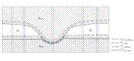
如果地层S i 属于第一类缺失地层,则S i 的缺失边界受控于下伏地层S i-1的顶面。如图5所示,经过第五步的插值,拟合出S i 的顶、底界面及其下伏地层S i-1的顶面、上覆地层S i+1的底面的初始形态。其中,S i 的顶面三角网记为F i_Top,底面三角网记为F i_Bottom,S i-1的顶面三角网记为F (i-1)_Top,S i+1的底面三角网记为F (i+1)_Bottom。 If the formation S i belongs to the first type of missing formation, the missing boundary of S i is controlled by the top surface of the underlying formation S i -1 . As shown in Figure 5, after the fifth step of interpolation, the initial shape of the top and bottom interfaces of Si , the top surface of the underlying stratum S i -1 , and the bottom surface of the overlying stratum S i +1 is fitted. Among them, the top triangular network of S i is recorded as F i _Top , the bottom triangular network is recorded as F i _Bottom , the top triangular network of S i -1 is recorded as F ( i -1)_Top , the bottom triangular network of S i +1 is The net is recorded as F ( i +1 )_Bottom .
首先,处理S i 的顶面三角网F i_Top。将F i_Top与F (i-1)_Top进行相交运算,求出这两个三角网的所有交点,作为新顶点插入到骨架三角网中,同时修改F i_Top、F (i-1)_Top以及其它全部地层顶、底界面三角网的顶点和拓扑关系。正常情况下,F i_Top中顶点的高程应不低于F (i-1)_Top上对应的顶点。但在S i 缺失的区域,会出现F i_Top顶点的高程低于F (i-1)_Top上对应顶点的高程的情况。这时,需要逐个抬高F i_Top顶点的高程值,将其设定为与F (i-1)_Top上对应顶点的高程值相等(如图5中黑色实线箭头所示)。修改后的F i_Top记为F ’ i_Top。 First, the top triangulation F i _Top of S i is processed. Intersect F i _Top and F ( i -1)_Top to find all the intersection points of these two triangulations, insert them into the skeleton triangulation as new vertices, and modify F i _Top and F ( i -1)_Top at the same time As well as vertices and topological relationships of triangular networks on top and bottom interfaces of all other formations. Under normal circumstances, the elevation of the vertex in F i _Top should not be lower than the corresponding vertex in F ( i -1)_Top . But in the area where S i is missing, the elevation of the vertex of F i _Top will be lower than the elevation of the corresponding vertex on F ( i -1)_Top . At this time, it is necessary to increase the elevation value of the F i _Top vertex one by one, and set it to be equal to the elevation value of the corresponding vertex on F ( i -1)_Top (as shown by the black solid arrow in Figure 5). The modified F i _Top is denoted as F ' i _Top .
然后,处理S i 的底面三角网F i_Bottom。从概念上来讲,F i_Bottom与F (i-1)_Top的相应顶点高程理应完全一致。但由于S i 是缺失地层,在第五步分别插值求取这两个三角网顶点高程时,使用的样本点并不一致,这导致插值拟合出的对应顶点高程也不完全相同。这需要通过界面交切处理与高程调整来实现两个界面的一致。本发明将F i_Bottom与F (i-1)_Top进行相交运算,求出这两个三角网的所有交点,作为新顶点插入到骨架三角网中,同时修改F i_Bottom、F (i-1)_Top以及其它全部地层顶、底界面三角网的顶点和拓扑关系;接着,逐个比较F i_Bottom与F (i-1)_Top的对应顶点高程是否相同:如果F i_Bottom顶点的高程低于(或高于)F (i-1)_Top上对应顶点的高程,则抬高(或压低)F i_Bottom顶点的高程值(如图5中黑色虚线箭头所示),将其设定为与F (i-1)_Top对应顶点的高程值相等。修改后的F i_Bottom记为F ’ i_Bottom。 Then, the bottom triangulation F i _Bottom of S i is processed. Conceptually, the corresponding vertex elevations of F i _Bottom and F ( i -1)_Top should be exactly the same. However, since S i is a missing stratum, the sample points used are not consistent when interpolating to obtain the vertex elevations of the two triangulation networks in the fifth step, which leads to the corresponding vertex elevations obtained by interpolation fitting are not exactly the same. This needs to achieve the consistency of the two interfaces through interface intersection processing and elevation adjustment. In the present invention, F i _Bottom and F ( i -1)_Top are intersected to obtain all the intersection points of the two triangulations, which are inserted into the skeleton triangulation as new vertices, and F i _Bottom and F ( i -1 )_Top and the vertices and topological relations of the top and bottom interface triangulations of all other formations; then, compare whether the corresponding vertex elevations of F i _Bottom and F ( i -1)_Top are the same one by one: if the elevation of the F i _Bottom apex is lower than ( or higher than) the elevation of the corresponding vertex on F ( i -1)_Top , then raise (or depress) the elevation value of the vertex of F i _Bottom (as shown by the black dotted arrow in Figure 5), and set it to be the same as F ( i -1)_Top corresponds to the same elevation value of the vertices. The modified F i _Bottom is denoted as F ' i _Bottom .
交切处理与高程调整后的缺失地层S i 的顶、底界面如图6所示。 Figure 6 shows the top and bottom interfaces of the missing formation S i after intersection processing and elevation adjustment.
(2)第二类缺失地层 (2) The second type of missing strata
如果地层S i 属于第二类缺失地层,则S i 的缺失边界受控于上覆地层S i+1的底面。如图8所示,经过第五步的插值,拟合出S i 的顶、底界面及其下伏地层S i-1的顶面、上覆地层S i+1的底面的初始形态。其中,S i 的顶面三角网记为F i_Top,底面三角网记为F i_Bottom,S i-1的顶面三角网记为F (i-1)_Top,S i+1的底面三角网记为F (i+1)_Bottom。 If the formation S i belongs to the second type of missing formation, the missing boundary of S i is controlled by the bottom surface of the overlying formation S i+1 . As shown in Fig. 8, after the fifth step of interpolation, the initial shape of the top and bottom interfaces of Si , the top surface of the underlying stratum S i -1 , and the bottom surface of the overlying stratum S i +1 are fitted. Among them, the top triangular network of S i is recorded as F i _Top , the bottom triangular network is recorded as F i _Bottom , the top triangular network of S i -1 is recorded as F ( i -1)_Top , the bottom triangular network of S i +1 is The net is recorded as F ( i +1 )_Bottom .
首先,处理S i 的底面三角网F i_Bottom。将F i_Bottom与F (i+1)_Bottom进行相交运算,求出这两个三角网的所有交点,作为新顶点插入到骨架三角网中,同时修改F i_Bottom、F (i+1)_Bottom以及其它全部地层顶、底界面三角网的顶点和拓扑关系。正常情况下,F i_Bottom中顶点的高程应不高于F (i+1)_Bottom上对应的顶点。但在S i 缺失的区域,会出现F i_Bottom顶点的高程高于F (i+1)_Bottom上对应顶点的高程的情况。这时,本发明需要逐个压低F i_Bottom顶点的高程值,将其设定为与F (i+1)_Bottom上对应顶点的高程值相等(如图8中黑色实线箭头所示)。修改后的F i_Bottom记为F’ i_Bottom。 First, the bottom triangulation F i _Bottom of S i is processed. Intersect F i _Bottom and F ( i +1)_Bottom to find all the intersection points of the two triangulations, insert them into the skeleton triangulation as new vertices, and modify F i _Bottom and F ( i +1)_Bottom at the same time As well as vertices and topological relationships of triangular networks on top and bottom interfaces of all other formations. Under normal circumstances, the elevation of the vertices in F i _Bottom should not be higher than the corresponding vertices in F ( i +1)_Bottom . But in the area where S i is missing, the elevation of the vertex of F i _Bottom will be higher than the elevation of the corresponding vertex on F ( i +1)_Bottom . At this time, the present invention needs to lower the elevation value of the F i _Bottom vertex one by one, and set it to be equal to the elevation value of the corresponding vertex on F ( i +1 )_Bottom (as shown by the black solid arrow in FIG. 8 ). The modified F i _Bottom is denoted as F' i _Bottom .
然后,处理S i 的顶面三角网F i_Top。从概念上来讲,F i_Top与F (i+1)_Bottom的相应顶点高程理应完全一致,但由于S i 是缺失地层,在第五步分别插值求取这两个三角网顶点高程时,使用的样本点并不一致,这导致插值拟合出的对应顶点高程也不完全相同。这需要通过界面交切处理与高程调整来实现两个界面的一致。本发明将F i_Top与F (i+1)_Bottom进行相交运算,求出这两个三角网的所有交点,作为新顶点插入到骨架三角网中,同时修改F i_Top、F (i+1)_Bottom以及其它全部地层顶、底界面三角网的顶点和拓扑关系;接着,逐个比较F i_Top与F (i+1)_Bottom的顶点高程是否相同:如果F i_Top顶点的高程低于(或高于)F (i+1)_Bottom上对应顶点的高程,则抬高(或压低)F i_Top顶点的高程值(如图8中黑色虚线箭头所示),将其设定为与F (i+1)_Bottom对应顶点的高程值相等。修改后的F i_Top记为F’ i_Top。 Then, the top triangulation F i _Top of S i is processed. Conceptually speaking, the corresponding vertex elevations of F i _Top and F ( i +1)_Bottom should be exactly the same, but since S i is a missing stratum, when interpolating to obtain the vertex elevations of the two triangulations in the fifth step, use The sample points are not consistent, which leads to the corresponding vertex elevations fitted by interpolation are not exactly the same. This needs to achieve the consistency of the two interfaces through interface intersection processing and elevation adjustment. In the present invention, F i _Top and F ( i +1)_Bottom are intersected to obtain all the intersection points of the two triangulations, which are inserted into the skeleton triangulation as new vertices, and F i _Top and F ( i +1 )_Bottom and the vertices and topological relations of the top and bottom interface triangulations of all other formations; then, compare whether the apex elevations of F i _Top and F ( i +1)_Bottom are the same one by one: if the elevation of the F i _Top apex is lower than (or higher than) the elevation of the corresponding vertex on F ( i +1)_Bottom , then raise (or depress) the elevation value of the vertex of F i _Top (as shown by the black dotted arrow in Figure 8), and set it to be the same as F ( i +1)_Bottom corresponds to the same elevation value of the vertices. The modified F i _Top is denoted as F' i _Top .
交切处理与高程调整后的地层S i 的顶、底界面如图9所示。 Figure 9 shows the top and bottom interfaces of strata S i after intersection processing and elevation adjustment.
第九步 缺失地层与邻接地层界面一致性处理 Step 9 Consistency processing between missing stratum and adjacent stratum interface
这一步的工作是按照第七步生成的缺失地层处理次序,逐个处理缺失地层与邻接地层的公共界面,以保证上下邻接地层公共界面的一致性。 The work of this step is to process the common interface between the missing strata and the adjacent strata one by one according to the missing stratum processing sequence generated in the seventh step, so as to ensure the consistency of the common interfaces of the upper and lower adjacent strata.
如果地层S i 属于第一类缺失地层,则逐个修改上覆地层S i+1底面三角网F (i+1)_Bottom的顶点高程,使其与F ’ i_Top完全相同。修改后的F (i+1)_Bottom记为F’ (i+1)_Bottom。如果地层S i 属于第二类缺失地层,则逐个修改下伏地层S i-1顶面三角网F (i-1)_Top的顶点高程,使其与F ’ i_Bottom完全相同。修改后的F (i-1)_Top记为F’ (i-1)_Top。一致性处理后的地层顶、底界面分别如图7(第一类缺失地层)、图10(第二类缺失地层)所示。 If the stratum S i belongs to the first type of missing strata, modify the vertex elevation of the bottom triangular network F ( i +1)_Bottom of the overlying stratum S i +1 one by one to make it exactly the same as F ' i _Top . The modified F ( i +1)_Bottom is denoted as F' ( i +1)_Bottom . If the stratum S i belongs to the second type of missing strata, modify the vertex elevation of the top triangular network F ( i -1)_Top of the underlying stratum S i -1 one by one to make it exactly the same as F ' i _Bottom . The modified F ( i -1)_Top is denoted as F' ( i -1)_Top . The top and bottom interfaces of strata after consistent processing are shown in Figure 7 (the first type of missing strata) and Figure 10 (the second type of missing strata), respectively.
经过上述处理,保证了所有邻接地层公共界面的一致性,即:所有地层(不论是完整地层,还是缺失地层)的顶面三角网与其上覆地层的底面三角网完全一致,所有地层的底面三角网与其下伏地层的顶面三角网完全一致。 After the above processing, the consistency of the public interface of all adjacent strata is ensured, that is, the top triangulation of all strata (whether it is a complete stratum or a missing stratum) is completely consistent with the bottom triangulation of the overlying strata, and the bottom triangulation of all strata The net is exactly the same as the top triangular net of the underlying formation.
第十步 生成三维实体模型 Step 10 Generate a 3D solid model
经过前面各步的处理,完成了各个地层顶、底界面三角网的重构工作,生成了由三角面片组成的地层顶、底界面。这一步的工作是:从下到上逐个处理各个地层,以其顶面三角网和底面三角网为空间基准,应用三维空间离散化方法对顶面三角网和底面三角网围成的空间进行剖分,生成用三棱柱体元充填的三维实体模型。 After the processing of the previous steps, the reconstruction of the triangular network of the top and bottom interfaces of each stratum is completed, and the top and bottom interfaces of the strata composed of triangular patches are generated. The work of this step is to process each stratum one by one from bottom to top, take the top and bottom TINs as the spatial reference, and use the three-dimensional space discretization method to dissect the space surrounded by the top and bottom TINs. points to generate a 3D solid model filled with triangular prism voxels.
第十一步 三维可视化分析 The eleventh step 3D visualization analysis
在计算机显示器上绘制出最终的沉积地层系统三维实体模型,以不同的颜色和亮度代表不同的地层和地质界面;然后,对生成的地层实体模型进行常规的可视化展示与专业的三维分析,包括三维观察、交互定位、模型剖切、隧洞开挖、体积量算等。基于三棱柱体元表示的三维实体模型非常适合于空间操作与空间分析,能够直观、准确、全面的展示三维地层模型的内部信息。 Draw the final three-dimensional solid model of the sedimentary stratigraphic system on the computer monitor, and use different colors and brightness to represent different strata and geological interfaces; then, perform conventional visual display and professional three-dimensional analysis on the generated stratum solid model, including three-dimensional Observation, interactive positioning, model cutting, tunnel excavation, volume measurement, etc. The 3D solid model based on triangular prism voxel representation is very suitable for spatial operation and spatial analysis, and can display the internal information of the 3D formation model intuitively, accurately and comprehensively.
下面介绍本发明在两个具有典型研究场区的实施结果。 The implementation results of the present invention in two typical research fields are introduced below.
(1)研究场区一:受控于侵蚀作用的沉积地层系统 (1) Research site 1: Sedimentary strata system controlled by erosion
第1个研究场区位于我国长江下游某城市中心城区,面积约500×500m2。如图11所示,研究区内7个控制性钻孔揭示了6个地层(从下到上依次简记为①~⑥),其中地层①、④~⑥是完整地层,②、③是缺失地层。研究区内的缺失地层属第二类缺失地层,主要受河流侵蚀和淤积作用控制。图12-图16展示了基于钻孔数据、使用本发明自动生成的各个地层的控制界面和三维实体模型。其中,图12展示了地层分界面的空间分布,图13、图14是从不同视角查看的三维实体模型,图15是过钻孔B2、B5、B4生成的剖面图,图16是对三维实体模型进行剖切操作后生成的栅状图。
The first research site is located in the central urban area of a city in the lower reaches of the Yangtze River in China, with an area of about 500×500m 2 . As shown in Fig. 11, 7 controlled drilling holes in the study area revealed 6 strata (abbreviated as ①~⑥ from bottom to top), among which
从图11-图16可以看出,使用本发明自动重构出来的地层顶、底界面形态自然,缺失地层的控制边界也很合理。为了定量评估这个模型的精度,使用实际工程建设过程中新增的钻孔和基坑开挖数据进行验证工作。结果发现,在本发明所构建的三维地层模型中,完整地层顶、底界面高程与实测数据的误差在5cm以内,缺失地层顶、底界面高程与实测数据的误差小于8cm。总体来看,模型的精度较高,可直接应用于工程实际。 From Figures 11 to 16, it can be seen that the top and bottom interfaces of the stratum automatically reconstructed by the present invention are natural, and the control boundary of the missing stratum is also very reasonable. In order to quantitatively evaluate the accuracy of this model, the newly added drilling and foundation pit excavation data in the actual engineering construction process are used for verification work. It was found that in the three-dimensional stratum model constructed by the present invention, the error between the elevation of the top and bottom interface of the complete stratum and the measured data is within 5cm, and the error between the elevation of the top and bottom interface of the missing stratum and the measured data is less than 8cm. Overall, the accuracy of the model is high, and it can be directly applied to engineering practice.
(2)研究场区二:非沉积和侵蚀复合叠加下的沉积地层系统 (2) Research site 2: Sedimentary stratigraphic system under the composite superposition of non-sedimentary and erosional strata
第二个研究场区位于我国长江下游某城市中心城区,面积约800×600m2。如图17所示,研究区内6个钻孔揭示了4个地层(从下到上依次简记为①~④),其中地层①、④是完整地层,②、③是缺失地层。图18-图22是使用这6个钻孔数据自动生成的各地层的控制界面以及三维实体模型。其中,图18展示了地层分界面的空间分布,图19、图20是从不同视角查看的三维实体模型,图21是过钻孔C2、C6、C5、C4生成的剖面,图22是对三维实体模型进行剖切操作后生成的栅状图。从图18-图22中可以看出,地层②、③在某些钻孔位置处(如C2)为非沉积缺失,在某些钻孔位置处(如C4)为侵蚀缺失,地层的顶、底界面受非沉积作用和侵蚀作用共同控制,因此属第三类缺失地层。实际工程也验证了这个模型的准确性。这个实例直观的展示了本发明处理复合缺失地层的有效性和合理性,说明其具有自动重构复杂地质条件下形成的沉积地层系统的能力。
The second research site is located in the central urban area of a city in the lower reaches of the Yangtze River in China, with an area of about 800×600m 2 . As shown in Fig. 17, six boreholes in the study area revealed four strata (abbreviated as ①~④ from bottom to top), among which
Claims (1)
Priority Applications (1)
| Application Number | Priority Date | Filing Date | Title |
|---|---|---|---|
| CN2011101816352A CN102254349B (en) | 2011-06-30 | 2011-06-30 | Method for constructing three-dimensional physical model of sedimentary stratum system by using drilling data |
Applications Claiming Priority (1)
| Application Number | Priority Date | Filing Date | Title |
|---|---|---|---|
| CN2011101816352A CN102254349B (en) | 2011-06-30 | 2011-06-30 | Method for constructing three-dimensional physical model of sedimentary stratum system by using drilling data |
Publications (2)
| Publication Number | Publication Date |
|---|---|
| CN102254349A CN102254349A (en) | 2011-11-23 |
| CN102254349B true CN102254349B (en) | 2012-11-28 |
Family
ID=44981590
Family Applications (1)
| Application Number | Title | Priority Date | Filing Date |
|---|---|---|---|
| CN2011101816352A Expired - Fee Related CN102254349B (en) | 2011-06-30 | 2011-06-30 | Method for constructing three-dimensional physical model of sedimentary stratum system by using drilling data |
Country Status (1)
| Country | Link |
|---|---|
| CN (1) | CN102254349B (en) |
Families Citing this family (28)
| Publication number | Priority date | Publication date | Assignee | Title |
|---|---|---|---|---|
| CN102880786A (en) * | 2012-08-10 | 2013-01-16 | 河海大学 | Kriging ground settlement time domain monitoring method based on simulated annealing method |
| CN103345540B (en) * | 2013-05-27 | 2014-08-13 | 华东师范大学 | Method for stimulating and displaying geological drilling information on digital earth software platform |
| SG11201600252QA (en) * | 2013-08-16 | 2016-02-26 | Landmark Graphics Corp | Identifying and extracting stratigraphic layers in one or more bodies representing a geological structure |
| CN105205863B (en) * | 2015-08-08 | 2018-02-13 | 山东万洲软件科技股份有限公司 | A kind of 3-dimensional digital basin modeling method for grading |
| CN105184864B (en) * | 2015-08-14 | 2018-12-11 | 中国能源建设集团安徽省电力设计院有限公司 | A kind of formation three-dimensional geological structural model generation method calculated for subsoil soil removal enginnering amount |
| CN106097445B (en) * | 2016-06-02 | 2019-10-29 | 广州市设计院 | A kind of method for drafting of three-dimensional formation curved surface |
| CN106558100B (en) * | 2016-10-25 | 2019-08-30 | 中国电建集团华东勘测设计研究院有限公司 | A Method for Automatic Formation of Stratum Model Based on Borehole Data |
| CN107180452A (en) * | 2017-05-02 | 2017-09-19 | 武汉中地数码科技有限公司 | The stratified geological objects modeling method of the multi-source data coupling on the stratum containing standard |
| CN108053395B (en) * | 2017-12-14 | 2018-12-04 | 中国矿业大学(北京) | A kind of underground disease recognition method based on irregular triangle network and space geometry method |
| CN108986213B (en) * | 2018-07-02 | 2022-02-11 | 南京师范大学 | Three-dimensional stratum modeling method based on stacking technology |
| CN109035411B (en) * | 2018-07-30 | 2021-07-20 | 中国石油化工股份有限公司 | Three-dimensional stratum corner grid voxel modeling method based on forward modeling |
| CN109359402B (en) * | 2018-10-26 | 2023-07-28 | 北京工商大学 | Three-dimensional soil layer construction method and device |
| CN109509397B (en) * | 2018-11-13 | 2020-10-13 | 浙江大学 | A data processing method for physical simulation experiment of hypergravity geological structure |
| CN109979011B (en) * | 2019-03-22 | 2019-12-31 | 李潇 | Construction method of 3D geological model in plain area based on multi-source heterogeneous data |
| CN109993832B (en) * | 2019-04-11 | 2020-09-11 | 中国矿业大学 | A method for constructing a refined three-dimensional model of coal seam in fully mechanized mining face |
| CN110443890B (en) * | 2019-07-08 | 2021-03-30 | 中南大学 | In-situ leaching deposit stratigraphic modeling method |
| CN110610539A (en) * | 2019-08-13 | 2019-12-24 | 北京中色地科测绘有限公司 | Stratum curved surface construction method, device, equipment and storage medium |
| CN112116708B (en) * | 2020-09-11 | 2022-06-21 | 中南大学 | Method and system for obtaining three-dimensional geological entity model |
| CN112419500B (en) * | 2020-12-09 | 2023-03-14 | 上海申元岩土工程有限公司 | Three-dimensional geological model modeling method |
| CN112686779B (en) * | 2020-12-16 | 2022-08-02 | 天津泰勘工程技术咨询有限公司 | Method for dividing sequence of standard soil layers of foundation soil |
| CN112446956B (en) * | 2021-02-01 | 2021-04-23 | 广汉前沿岩土科技有限公司 | Geological three-dimensional model construction method based on drilling data |
| CN113269879B (en) * | 2021-05-27 | 2021-11-26 | 广东省地震局 | Automatic construction method and device for three-dimensional model of geologic body |
| CN114332413A (en) * | 2022-01-06 | 2022-04-12 | 河海大学 | A geological body modeling method and device based on sliding kriging interpolation |
| CN114625946B (en) * | 2022-02-25 | 2025-03-07 | 浙江数智交院科技股份有限公司 | Stratum zoning method, device, electronic device and readable storage medium |
| CN116206079B (en) * | 2023-05-06 | 2023-06-30 | 中南大学 | Moving tetrahedron-based geologic body modeling method and related equipment |
| CN118916948B (en) * | 2023-05-06 | 2025-09-26 | 中国石油天然气股份有限公司 | A method and system for intelligent modeling of stratigraphic framework in large working areas |
| CN116721224B (en) * | 2023-05-31 | 2024-05-31 | 北京龙软科技股份有限公司 | Geological attribute dynamic modeling method based on stratum triangle network model |
| CN119006732B (en) * | 2024-10-17 | 2024-12-27 | 四川水发勘测设计研究有限公司 | Three-dimensional geological modeling method capable of adding arbitrary constraint for overburden stratum |
Family Cites Families (1)
| Publication number | Priority date | Publication date | Assignee | Title |
|---|---|---|---|---|
| CN101303414B (en) * | 2008-05-22 | 2011-03-30 | 北京航空航天大学 | A Level Set-Based Method for Generating Strata and Geological Bodies |
-
2011
- 2011-06-30 CN CN2011101816352A patent/CN102254349B/en not_active Expired - Fee Related
Also Published As
| Publication number | Publication date |
|---|---|
| CN102254349A (en) | 2011-11-23 |
Similar Documents
| Publication | Publication Date | Title |
|---|---|---|
| CN102254349B (en) | Method for constructing three-dimensional physical model of sedimentary stratum system by using drilling data | |
| Zhu et al. | Building 3D solid models of sedimentary stratigraphic systems from borehole data: an automatic method and case studies | |
| CN1858803A (en) | Three dimension uniform model construction method of water conservancy hydropower engineering geological information | |
| CN103279986B (en) | Three-dimensional horizontal geologic profile figure preparation method and application thereof | |
| CN101906965B (en) | Technology for identifying and analyzing stratums in VR (Virtual Reality) geological environment | |
| CN106023313B (en) | A kind of three-dimensional geological number exploration report generation method | |
| CN112381937A (en) | Multi-source geological data coupling modeling method based on drilling and complex geological profile | |
| CN102609982B (en) | Topology discovery method of space geological data based on unstructured mode | |
| CN103279988A (en) | Virtual city overground space and underground space integrated 3D modeling method | |
| CN102651143A (en) | Automatically generating method of pinchout geological body three-dimensional complex profile | |
| CN103632397B (en) | Multi-block multi-unit three-dimensional geological survey method | |
| Zhang et al. | A case study on integrated modeling of spatial information of a complex geological body | |
| CN115469361B (en) | Clastic rock stratum three-dimensional geological modeling method | |
| Zhang et al. | 3D parametric modeling of complex geological structures for geotechnical engineering of dam foundation based on t‐splines | |
| CN114549774A (en) | Three-dimensional stratum modeling method based on drilling data | |
| CN117197377A (en) | Three-dimensional dynamic visualization modeling method of mining area | |
| CN111859497B (en) | A method for object-oriented modeling and analysis of geological blocks | |
| CN114332391A (en) | Three-dimensional geologic body probability model modeling method | |
| CN118608705A (en) | A method for constructing a transparent three-dimensional geological model based on virtual borehole completion | |
| CN109615696B (en) | A 3D visualization processing method for engineering geological information | |
| Yuan et al. | 3D geological fine modeling and dynamic updating method of fault slope in open-pit coal mine | |
| CN115795974A (en) | Space-air-ground integrated monitoring method for groundwater seepage field evolution in deep tunnels | |
| Hao et al. | Research and application of urban three-dimensional geological modeling technology based on multiple and complex geological structures: a case study of Chengdu, China | |
| CN118644626B (en) | Method and system for collaborative construction of urban-level geological model and engineering-level geological model | |
| CN117635864B (en) | Mixed modeling method and related device for complex three-dimensional geologic body of deposit |
Legal Events
| Date | Code | Title | Description |
|---|---|---|---|
| C06 | Publication | ||
| PB01 | Publication | ||
| C10 | Entry into substantive examination | ||
| SE01 | Entry into force of request for substantive examination | ||
| C14 | Grant of patent or utility model | ||
| GR01 | Patent grant | ||
| CF01 | Termination of patent right due to non-payment of annual fee |
Granted publication date: 20121128 Termination date: 20150630 |
|
| EXPY | Termination of patent right or utility model |