CN101711368B - Method and system for processing of satellite positioning system signals - Google Patents
Method and system for processing of satellite positioning system signals Download PDFInfo
- Publication number
- CN101711368B CN101711368B CN200880021721.3A CN200880021721A CN101711368B CN 101711368 B CN101711368 B CN 101711368B CN 200880021721 A CN200880021721 A CN 200880021721A CN 101711368 B CN101711368 B CN 101711368B
- Authority
- CN
- China
- Prior art keywords
- processing
- data
- satellite
- record
- sampling
- Prior art date
- Legal status (The legal status is an assumption and is not a legal conclusion. Google has not performed a legal analysis and makes no representation as to the accuracy of the status listed.)
- Active
Links
Images


Classifications
-
- G—PHYSICS
- G01—MEASURING; TESTING
- G01S—RADIO DIRECTION-FINDING; RADIO NAVIGATION; DETERMINING DISTANCE OR VELOCITY BY USE OF RADIO WAVES; LOCATING OR PRESENCE-DETECTING BY USE OF THE REFLECTION OR RERADIATION OF RADIO WAVES; ANALOGOUS ARRANGEMENTS USING OTHER WAVES
- G01S5/00—Position-fixing by co-ordinating two or more direction or position line determinations; Position-fixing by co-ordinating two or more distance determinations
- G01S5/0009—Transmission of position information to remote stations
- G01S5/0018—Transmission from mobile station to base station
- G01S5/0036—Transmission from mobile station to base station of measured values, i.e. measurement on mobile and position calculation on base station
-
- G—PHYSICS
- G01—MEASURING; TESTING
- G01S—RADIO DIRECTION-FINDING; RADIO NAVIGATION; DETERMINING DISTANCE OR VELOCITY BY USE OF RADIO WAVES; LOCATING OR PRESENCE-DETECTING BY USE OF THE REFLECTION OR RERADIATION OF RADIO WAVES; ANALOGOUS ARRANGEMENTS USING OTHER WAVES
- G01S19/00—Satellite radio beacon positioning systems; Determining position, velocity or attitude using signals transmitted by such systems
- G01S19/01—Satellite radio beacon positioning systems transmitting time-stamped messages, e.g. GPS [Global Positioning System], GLONASS [Global Orbiting Navigation Satellite System] or GALILEO
- G01S19/13—Receivers
- G01S19/24—Acquisition or tracking or demodulation of signals transmitted by the system
Landscapes
- Engineering & Computer Science (AREA)
- Radar, Positioning & Navigation (AREA)
- Remote Sensing (AREA)
- Physics & Mathematics (AREA)
- General Physics & Mathematics (AREA)
- Computer Networks & Wireless Communication (AREA)
- Position Fixing By Use Of Radio Waves (AREA)
Abstract
本发明提供了一种对来自卫星定位系统的信号进行处理的方法,包括:接收(50)记录的卫星广播的数据采样块,每个块包括记录采样时接收机内产生的一个或多个时间戳,以及使用第一组处理参数来对记录的数据采样进行处理(52),以识别包含于所述块内的卫星传输。给予该处理(52)结果,选择(56,58)所述块之一。使用第二组处理参数来对所选择的块进行处理(60),以至少获得定位和卫星广播计时信息。使用所选择块的时间戳以及从对所选择块的处理(60)获得的计时信息来帮助其他块的处理(60)。本方法结合时间戳与卫星数据,以改进定位数据的脱机处理(例如通过提供数据采样之间的准确的相关计时信息),并且这减小了处理这些数据所需的处理功率和/或时间。
This invention provides a method for processing signals from a satellite positioning system, comprising: receiving (50) recorded data sampling blocks of satellite broadcasts, each block including one or more timestamps generated within the receiver at the time of recording sampling; and processing (52) the recorded data samplings using a first set of processing parameters to identify satellite transmissions contained within the block. As a result of the processing (52), one of the blocks is selected (56, 58). The selected block is processed (60) using a second set of processing parameters to obtain at least positioning and satellite broadcast timing information. The timestamps of the selected block and the timing information obtained from the processing (60) of the selected block are used to assist in the processing (60) of other blocks. This method combines timestamps with satellite data to improve offline processing of positioning data (e.g., by providing accurate correlation timing information between data samplings), and this reduces the processing power and/or time required to process this data.
Description
技术领域 technical field
本发明涉及一种卫星定位系统(诸如GPS),尤其涉及一种在这种系统内处理信号的方法。The present invention relates to a satellite positioning system, such as GPS, and more particularly to a method of processing signals within such a system.
背景技术 Background technique
导航系统是包括多达32个处于6个不同轨道面的轨道卫星(也被称为宇宙飞船,“SV”)的网络的卫星导航系统。系统设计需要24个卫星,但是更多的卫星可以提高覆盖范围。所述卫星不断地移动,24小时正好围绕地球完成两次轨道运行。The navigation system is a satellite navigation system comprising a network of up to 32 orbiting satellites (also called Spacecraft, "SV") in 6 different orbital planes. The system design calls for 24 satellites, but more satellites can improve coverage. The satellite is constantly moving, completing exactly two orbits around the earth in 24 hours.
每个卫星以多个频率传输。民用GPS普遍使用1575.42MHz的‘L1’频率来接收。卫星轨道为远离地球中心的约25,000千米处,或者为远离地球表面的20,000于米处。这些卫星的轨道路径大约在北纬60度与南纬60度之间。Each satellite transmits on multiple frequencies. Civilian GPS generally uses the 'L1' frequency of 1575.42MHz to receive. Satellite orbits are approximately 25,000 kilometers away from the center of the Earth, or 20,000 meters away from the Earth's surface. The orbital paths of these satellites are approximately between 60°N and 60°S.
由卫星传输的GPS信号的形式通常被称为直接序列扩谱,其采用以规则的方式不断重复的伪随机码。所述卫星使用不同的扩频码来广播多个信号,不同的扩频码包括公众可以容易地获取的粗捕获(C/A)码以及通常保留用于军事应用的受限的精(P)码。C/A码是1,023比特长的伪随机码,采用1,023MHz的码片速率来广播,每毫秒重复一次。每个卫星发送不同的可以被唯一地识别的C/A码。The form of GPS signal transmitted by the satellites is often called direct sequence spread spectrum, which employs a pseudo-random code that repeats in a regular pattern. The satellite broadcasts multiple signals using different spreading codes including the coarse acquisition (C/A) code which is readily available to the public and the restricted fine (P) code which is usually reserved for military applications. code. The C/A code is a 1,023-bit pseudo-random code that is broadcast at a chip rate of 1,023 MHz and repeats every millisecond. Each satellite transmits a different C/A code that can be uniquely identified.
每个卫星对C/A码上的数据信息进行调制,该数据信息包括重要的信息,诸如传送卫星(也被称为宇宙飞行器)的详细的轨道参数、关于卫星时钟的误差信息、卫星的状态(健康或不健康)、当前数据、以及时间。信号的这个部分是GPS接收机确定准确位置所必须的。每个卫星仅传送星历表以及其详细的时钟校正参数,因此独立的GPS接收机必须对每个卫星的数据信息的适当部分进行处理以用于定位计算。Each satellite modulates data information on the C/A code, which includes important information such as detailed orbital parameters of the transmitting satellite (also known as a space vehicle), error information about the satellite clock, status of the satellite (healthy or unhealthy), current data, and time. This portion of the signal is necessary for a GPS receiver to determine an accurate position. Each satellite transmits only the ephemeris and its detailed clock correction parameters, so a separate GPS receiver must process the appropriate portion of each satellite's data information for use in position calculations.
所述数据信息还包含所谓的历书,其包括关于所有其他卫星的精度较低的信息,并且其更新频率较低。历书数据使得GPS接收机可以估计每个GPS卫星在全天的任意时间应该在哪里,以使所述接收机可以选择卫星来进行更有效的搜索。每个卫星传输表示系统中每个卫星的轨道信息的历书数据。The data information also contains the so-called almanac, which contains less precise information about all other satellites and which is updated less frequently. Almanac data allows a GPS receiver to estimate where each GPS satellite should be at any time throughout the day so that the receiver can select satellites for a more efficient search. Each satellite transmits almanac data representing orbital information for each satellite in the system.
传统的GPS接收机读取所传输的信息并且保存星历表、历书以及其他数据以供重复使用。该信息也可以用于设置(或校正)GPS接收机中的时钟。Conventional GPS receivers read the transmitted information and save ephemeris, almanac, and other data for reuse. This information can also be used to set (or correct) the clock in the GPS receiver.
为了确定位置,GPS接收机对卫星传输信号的时间与GPS接收机接收该信号的时间进行比较。时间差向GPS接收机显示特定卫星距离多远。通过比较从多个卫星的距离测量,可以通过三边测量法来获知位置。通过使用最少三个卫星,GPS接收机可以确定纬度/经度位置(2D定位),通过使用四个或更多卫星,GPS接收机可以确定包括纬度、经度以及海拔的3D位置。To determine position, a GPS receiver compares the time at which a signal was transmitted by a satellite with the time at which the signal was received by the GPS receiver. The time difference shows the GPS receiver how far away a particular satellite is. By comparing distance measurements from multiple satellites, location can be known through trilateration. By using a minimum of three satellites, a GPS receiver can determine a latitude/longitude position (2D positioning), and by using four or more satellites, a GPS receiver can determine a 3D position including latitude, longitude, and altitude.
通过对来自卫星的信号的明显多普勒频移进行处理,GPS接收机还可以准确地提供运行速度和方向(被称为‘对地速度’和‘地面航迹’)。By processing the apparent Doppler shift of the signals from the satellites, GPS receivers can also accurately provide operational speed and direction (known as 'speed over ground' and 'ground track').
来自卫星的一个完整的数据信号包括37,500比特的导航信息,以1500比特每秒的速度发送需要花费12.5分钟。所述数据信号被分为25个30秒的帧,每帧具有1500比特,并且这些帧再被分为5个6秒的子帧。每个6秒的子帧又被分为10个30比特的字。每帧内包含用于定位的所有必要信息(星历表等),因此,GPS接收机从所谓的冷启动开始通常将花费约30秒的时间来产生定位。A complete data signal from a satellite, including 37,500 bits of navigation information, takes 12.5 minutes to send at 1,500 bits per second. The data signal is divided into 25 30-second frames of 1500 bits each, and these frames are further divided into five 6-second subframes. Each 6-second subframe is further divided into ten 30-bit words. Each frame contains all the necessary information for a position fix (ephemera, etc.), so a GPS receiver will typically take around 30 seconds to generate a position fix from a so-called cold start.
每个6秒的子帧的第一个字包含前同步信号,以使接收机可以确认该子帧的开始。下一个字是转换字,其给出GPS时间的最近的重启动(发生在每个周六/周日的午夜)之后的计时信息。剩余的8个字提供星历表、历书以及时钟信息,这取决于子帧。The first word of each 6-second subframe contains a preamble so that the receiver can acknowledge the start of the subframe. The next word is the conversion word, which gives the timing information after the most recent restart of GPS time (occurring every Saturday/Sunday at midnight). The remaining 8 words provide ephemeris, almanac, and clock information, depending on the subframe.
第一子帧给出时钟校正数据,第二和第三子帧给出星历表数据,并且在第四和第五子帧中给出历书数据。The first subframe gives clock correction data, the second and third subframes give ephemeris data, and the fourth and fifth subframes give almanac data.
所有的SV以相同的频率广播。为了区分来自特定卫星的信号,接收机需要产生卫星所使用的已知的C/A码的拷贝并且对其进行对准,以使其与输入信号同步,该信号由于从卫星到接收机传输过程中信号的飞行时间而被延迟显著的未知量的时间(通常约0.07秒)。通常,接收机不可能准确地预测出获得与输入信号同步的拷贝所需的对准,因此需要某种搜索形式,依次尝试许多对准并且选择最佳匹配。这种估计多个候选对准的处理通常被称为校正,如接收机依次对每个卫星执行接收信号与已知的C/A码之间的相关函数,以确定接收信号是否包括具有来自特定SV的C/A码的分量。必须针对多个相对计时来计算相关函数,并且当找到相关峰值时,则对应于特定计时和特定SV。所找到的计时依次对应于距离SV的特定距离。All SVs broadcast on the same frequency. In order to distinguish a signal from a particular satellite, the receiver needs to generate a copy of the known C/A code used by the satellite and align it so that it is synchronized with the incoming signal due to the transmission process from the satellite to the receiver. The time-of-flight of the medium signal is delayed by a significant unknown amount of time (typically about 0.07 seconds). Often it is not possible for the receiver to predict exactly the alignment needed to obtain a copy that is synchronized with the incoming signal, so some form of search is required, trying many alignments in sequence and choosing the best match. This process of estimating multiple candidate alignments is often referred to as calibration, as the receiver performs a correlation function between the received signal and a known C/A code for each satellite in turn to determine whether the received signal includes Components of the C/A code of the SV. The correlation function has to be calculated for multiple relative timings, and when a correlation peak is found, it corresponds to a specific timing and a specific SV. The timings found in turn correspond to a certain distance from SV.
所确定的码相位(即相关函数的峰值的计时)显示用于距离计算的准确的计时信息。但是,因为每毫秒重复编码,因此还需要确定粗计时。通常,重复数据分量的较低频率被用于更粗的计时估计(例如,为了获得GPS时间),诸如50比特每秒的数据信息的单个比特以及诸如子帧转换字的子帧前同步信号的特定部分。The determined code phase (ie the timing of the peak of the correlation function) reveals accurate timing information for the distance calculation. However, since the encoding is repeated every millisecond, a coarse timing also needs to be determined. Typically, lower frequencies of repeating data components are used for coarser timing estimates (e.g., to obtain GPS time), individual bits of data information such as 50 bits per second and subframe preambles such as subframe transition words specific part.
执行相关函数的集成周期来确定对使用特定码进行编码的信号进行识别的容易程度;通常,对于给定的信号长度来说,集成周期越长,校正码相位越可靠。要检测的信号越微弱,用来获得相同的可靠级别的集成周期越长。The integration period over which the correlation function is performed determines how easily a signal encoded with a particular code can be identified; in general, for a given signal length, the longer the integration period, the more reliable the correct code phase. The weaker the signal to be detected, the longer the integration period to achieve the same level of reliability.
几乎所有当前的和历史的GPS接收机都“实时地”处理来自卫星的信号,在它们到达时实时地报告装置的位置。已知与这种传统接收机相关的技术。Almost all current and historical GPS receivers process signals from satellites in "real time", reporting the location of the device in real time as they arrive. Techniques related to such conventional receivers are known.
这种“传统的”GPS接收机必定包括:Such a "traditional" GPS receiver must include:
-用于接收GPS信号的天线,- an antenna for receiving GPS signals,
-模拟射频电路,设计用于对所需信号进行放大、滤波并混合下变频至中频(IF),以使其可以以约几MHz的正常采样速率经历适当的模数(A/D)转换,- an analog RF circuit designed to amplify, filter and mix down-convert the desired signal to an intermediate frequency (IF) so that it can undergo appropriate analog-to-digital (A/D) conversion at the normal sampling rate of about a few MHz,
-数字信号处理硬件,其对由A/D转换器产生的IF数据采样进行相关处理,通常与微控制器的某种形式结合,所述微控制器用来执行控制信号处理硬件和计算期望的定位所需的“更高级别”的处理。- Digital signal processing hardware which correlates the IF data samples produced by the A/D converter, usually in combination with some form of microcontroller which is used to perform control of the signal processing hardware and calculate the desired positioning Required "higher level" processing.
但是,本发明还研究了不太有名的“存储并稍后处理”的构思。这涉及到将由传统天线和模拟射频电路收集的IF数据采样先存储于某种形式的存储器中,稍后(几秒、几分钟、几小时或者甚至是几天之后)并且通常在其他处理资源更丰富的地方再对其进行处理。However, the present invention also investigates the less well-known "store and process later" concept. This involves storing the IF data samples collected by conventional antennas and analog RF circuitry first in some form of memory and later (seconds, minutes, hours, or even days later) and often after other processing resources are more efficient. Rich place and then deal with it.
对传统的GPS接收机来说,存储并稍后处理的方法的关键的优点在于:由于在捕获时不需要进行数字信号处理,捕获装置的成本和功耗将保持为最小,并且抓取时间可以非常短(例如,100毫秒)。当可以通过某种其他方法来获得相关卫星数据(星历表等)时执行随后的信号处理,该方法还除去了在捕获装置中解码(非常慢)来自SV的数据信息的需要,所述解码在许多情况下导致启动传统装置所需的不可接受长的时间。The key advantage of the store-and-process-later approach to conventional GPS receivers is that since no digital signal processing is required at the time of acquisition, the cost and power consumption of the acquisition device will be kept to a minimum, and the acquisition time can be Very short (eg, 100 milliseconds). Subsequent signal processing is performed when the relevant satellite data (ephemerides, etc.) This leads in many cases to an unacceptably long time required to start up conventional devices.
例如,接着,存储器中存储了IF数据采样的较短“抓取”的多个小捕获装置可以将其IF数据抓取上传到共享的中央计算机,该共享的中央计算机不仅通过连接至一个或多个传统GPS接收机执行必要的信号处理(相关等),还具有对存储有最近的卫星信息(星历表等)的数据库的访问,传统的GPS接收机将其所接收到的GPS数据信息的关键部分转达给中央计算机。For example, multiple small capture devices with shorter "snaps" of IF data samples stored in memory can then upload their IF data grabs to a shared central computer that not only connects to one or more A conventional GPS receiver performs the necessary signal processing (correlation, etc.) and also has access to a database storing the latest satellite information (ephemeris, etc.). The critical part is conveyed to the central computer.
但是,随后的处理的容易程度和有效性受收集IF数据的方式的影响。有利的是存储尽可能小的数据,以减小对存储器和处理的需求,但是这使得更难获得定位。However, the ease and effectiveness of subsequent processing is affected by the manner in which IF data is collected. It is advantageous to store as little data as possible to reduce memory and processing requirements, but this makes it harder to obtain a location.
发明内容 Contents of the invention
根据本发明,提供了一种对来自卫星定位系统的信号进行处理的方法,其包括:According to the present invention, there is provided a method for processing signals from a satellite positioning system, comprising:
接收卫星广播的数据采样的记录块,每个块包括记录采样的接收机内产生的一个或多个时间戳;receiving recorded blocks of data samples broadcast by the satellite, each block including one or more time stamps generated within the receiver recording the samples;
通过使用第一组处理参数来对数据采样的记录块进行处理,以识别包含于所述块的卫星传输;processing a block of records of data samples using a first set of processing parameters to identify satellite transmissions contained in the block;
根据处理结果选择一个块;Select a block based on the processing result;
通过使用第二组处理参数来对所选择的块进行处理,以至少获得位置和卫星广播计时信息;以及processing the selected block using a second set of processing parameters to obtain at least position and satellite broadcast timing information; and
通过使用所选择块的时间戳和从对所选择块的处理获得的计时信息来帮助处理其他块。Helps process other blocks by using the timestamp of the selected block and timing information obtained from processing the selected block.
本发明的方法结合时间戳与卫星数据(例如,中频“IF”数据)来改进定位数据的脱机处理,并且这可以减小处理这些数据所需的功率和/或时间。The method of the present invention combines timestamps with satellite data (eg, intermediate frequency "IF" data) to improve off-line processing of positioning data, and this can reduce the power and/or time required to process these data.
所述定位系统通常为GPS系统。The positioning system is usually a GPS system.
来自GPS前端的数据块(即,IF数据)连同相关的时间戳一起被记录,并且这种IF数据的随后的处理使用该时间戳来确定绝对和/或相对计时,以便于更有效或有效地对位置或速率进行计算。Chunks of data from the GPS front-end (i.e., IF data) are recorded along with associated timestamps, and subsequent processing of such IF data uses the timestamps to determine absolute and/or relative timing in order to more efficiently or effectively Calculate position or velocity.
对所选择块的时间戳和从对所选择的块进行处理获得的计时信息的使用可以包括:通过使用所选择块的时间戳与其他块之间的相关计时来预测其他块的计时信息。基于局部产生的时间戳的该相对计时可以足够准确,从而使用已知的较小的计时窗来对随后的块进行处理。Using the time stamp of the selected block and timing information obtained from processing the selected block may include predicting timing information of other blocks by using the time stamp of the selected block and relative timing between other blocks. This relative timing based on locally generated timestamps may be accurate enough that subsequent blocks are processed using known smaller timing windows.
从对所选择块进行处理获得的定位信息可以被用于预测记录其他块的大约位置,并且其还可以被用于简化对其他块的处理。Positioning information obtained from processing the selected block can be used to predict the approximate location where other blocks are recorded, and it can also be used to simplify the processing of other blocks.
通过使用第二组处理参数来对所选择块进行处理还可以获得卫星广播频率,也可以根据针对所选择块获得的频率来预测针对其他块的卫星广播频率,从而使得对随后的块进行的处理不(或很少)需要扫频。The satellite broadcast frequency can also be obtained by processing the selected block using the second set of processing parameters, and the satellite broadcast frequency for other blocks can also be predicted from the frequency obtained for the selected block, so that the processing of the subsequent block No (or very little) frequency sweeping is required.
对数据的每个其他块的处理可以使用一个或多个先前处理的数据块和相应的位置以及计时信息来帮助处理。因此,对每个块的处理可以使用一个或多个先前获得的数据。Processing of each other chunk of data may use one or more previously processed chunks of data and corresponding location and timing information to aid in processing. Therefore, the processing of each block may use one or more previously obtained data.
采样可以包括中频下变频变换了的数据采样。The samples may include IF down-converted data samples.
使用第一组处理参数的处理可以包括:使用比第二组处理参数中所使用的集成周期较短的集成周期来识别卫星传输。例如所述较短的集成周期可以是短于5毫秒,优选地约为2毫秒。每个记录采样可以具有少于500毫秒的持续时间。Processing using the first set of processing parameters may include identifying satellite transmissions using an integration period shorter than that used in the second set of processing parameters. For example said short integration period may be shorter than 5 milliseconds, preferably about 2 milliseconds. Each recording sample may have a duration of less than 500 milliseconds.
使用第一和第二组处理参数的对采样的处理可以包括:对数据库的访问,以获得对应于时间戳的时间的星历表信息。这被用于访问单独建立的存储有历史星历表(以及其他SV参数)的数据库,从而减小需要从接收机接收的数据量。Processing of the samples using the first and second sets of processing parameters may include accessing a database to obtain ephemeris information corresponding to the time of the time stamp. This is used to access a separately built database storing historical ephemeris (and other SV parameters), thereby reducing the amount of data that needs to be received from the receiver.
本发明的方法脱离了传统的连续处理GPS数据的方法,并且提供了以最节约处理功率的顺序执行的数据处理。因此,为了获得定位而处理的第一采样可以不是第一记录的采样。The method of the present invention deviates from the traditional method of continuously processing GPS data and provides data processing performed in the order that saves the most processing power. Thus, the first sample processed to obtain a position fix may not be the first recorded sample.
本发明还提供了一种接收机内对来自卫星定位系统的信号进行处理的方法,包括:The present invention also provides a method for processing signals from a satellite positioning system in a receiver, including:
记录卫星广播的数据采样块;Record data sample blocks for satellite broadcasts;
产生记录块的本地时间戳;Generate a local timestamp of the record block;
向处理系统提供数据采样的记录块和本地时间戳。Provides the processing system with a record block of data samples and a local timestamp.
本发明还提供一种用于收集来自卫星定位系统的数据的系统,包括:The present invention also provides a system for collecting data from a satellite positioning system, comprising:
天线;antenna;
接收机前端,其具有数字化的中频信号的输出;a receiver front end having an output of a digitized intermediate frequency signal;
存储器装置;memory device;
本地计时器;local timer;
控制器;以及controller; and
传送装置,其中所述控制器用于在存储器中存储前端信号与本地计时器产生的相关时间戳,并且所述传送装置用于向处理系统提供记录采样和本地时间戳。Transfer means, wherein said controller is adapted to store front-end signals in memory with associated time stamps generated by a local timer, and said transfer means is configured to provide recording samples and local time stamps to a processing system.
附图说明 Description of drawings
此处将参考附图来详细地描述本发明的示例,其中:Examples of the invention will be described in detail herein with reference to the accompanying drawings, in which:
图1示出了本发明的系统;Figure 1 shows the system of the present invention;
图2示出了本发明的系统中使用的数据记录方法;以及Figure 2 shows the data recording method used in the system of the present invention; and
图3示出了本发明的系统中使用的数据处理方法。Fig. 3 shows the data processing method used in the system of the present invention.
具体实施方式 Detailed ways
本发明提供了一种对存储的卫星定位系统数据(诸如GPS数据)进行处理的方法。这可以被用于许多存储和处理应用中,其中有利的是,接收机可以除去GPS信号处理的能力,而通过远程执行该处理。The present invention provides a method of processing stored satellite positioning system data, such as GPS data. This can be used in many storage and processing applications where it would be advantageous for the receiver to remove the ability to process GPS signals and perform the processing remotely.
本发明通过利用已知的多个采样之间的相对计时,同时使用时标与记录的GPS采样,以使可以进行更有效的多采样的处理。The present invention enables more efficient multi-sampling processing by taking advantage of the known relative timing between multiple samples, using time stamps simultaneously with recorded GPS samples.
为了说明本发明,将给出运动追踪装置的示例,其用于追踪诸如跑步者之类的运动员。图1中示出了该装置的关键部件。In order to illustrate the invention, an example of a motion tracking device will be given which is used to track an athlete such as a runner. The key components of the device are shown in Figure 1.
来自GPS卫星的信号被天线10接收并且接着完成传统的模拟处理,通常包括单元12中的放大、滤波以及向下混频的组合,并且其后面是单元16中的A/D转换,单元12由参考振荡器14驱动。这是形成射频前端的传统的无线电接收机电子设备。Signals from the GPS satellites are received by
结合程序包被实现为:离散逻辑或微处理器的控制器18选择将要存储于存储器装置20(例如闪存、硬盘等)中的由射频前端产生的采样IF数据的部分。实现该选择的方式受用户设置(例如由GUI 22输入)以及对计时器24的使用的影响,如图所示,计时器24也可以由振荡器14驱动。The binding program package is implemented as: the
计时器24可以像由仅当装置被激活时运行的振荡器驱动的计数器一样简单,或者其可以是即使当装置关闭时仍然保留日期和时间的实时时钟(RTC)。其可以具有单独的振荡器来使“断开”所使用的能量最小化。The
当被激活时,装置连同从计时器24获得的相关时间戳一起记录来自射频前端的较短的IF数据块(下文中这些较短的数据块被称为“抓取”)。例如,这些抓取可以是100毫秒长,并且每10秒可以对其记录一次。所使用的精确值可以由用户通过GUI 22明显地或隐含地改变。When activated, the device records shorter blocks of IF data from the RF front-end (hereinafter these shorter blocks are referred to as "grabs") along with the associated time stamp obtained from the
在不同的应用中,将采用不同长度的抓取。通常,每个抓取将短于6秒持续时间的子帧,并且优选小于500毫秒。In different applications, grips of different lengths will be used. Typically, each grab will be shorter than a subframe of 6 second duration, and preferably less than 500 milliseconds.
较短的抓取可以获得码相位测量。但是,在标准的GPS接收机中,码相位测量是不明确的(如上所述),这表示延迟为1毫秒的几分之几,而不是整数毫秒。Shorter captures can obtain code phase measurements. However, in a standard GPS receiver, the code phase measurement is ambiguous (as mentioned above), which means that the delay is fractions of 1 millisecond, not whole milliseconds.
可以以多种方式来解决这种不确定性:This uncertainty can be resolved in a number of ways:
1)尝试所有可能的延迟。SV距地球表面的距离约为20,000千米。事实上,这意味着从地球观察到的延迟大约在65毫秒至85毫秒的范围内。理论上,可以尝试所有可能的值(每个SV约21个值),期望只有一个值给出合理的结果。但是,由于需要至少四个SV,因此排列变化(permutation)的数量非常快地变得非常大,并且多于一组的延迟可能也是似乎正确的。1) Try all possible delays. The distance of the SV from the Earth's surface is about 20,000 km. In practice, this means that the observed delay from Earth is roughly in the range of 65 milliseconds to 85 milliseconds. In theory, one could try all possible values (about 21 values for each SV), expecting only one value to give reasonable results. However, since at least four SVs are required, the number of permutations becomes very large very quickly, and a delay of more than one set may also seem correct.
2)确定比特边缘位置。数据比特为20毫秒长(50比特每秒=>0.02秒每比特)并且与C/A码对准,从而使每个数据比特与1毫秒编码的20个完全重复对准。如果可以确定比特边缘发生在哪个编码的信号出现时间,则存在针对20毫秒而不是之前的1毫秒的延迟测量。这有效地减小了针对每个SV少于2个可能值的不确定性(在许多情况下不存在不确定性)并且尝试所有的排列变化变得完全似乎合理。唯一的困难是如何确定所述比特边缘。事实上,比特边缘每20毫秒发生一次,但是仅仅是在数据比特改变的情况下才会发生。如果存在1秒或0秒的长序列,则不会检测到比特边缘。此外,对于微弱的信号,可以期望看到几个确实已正确获取的比特边缘。因此,通常需要处理多达1秒的数据以确定可靠的答案。2) Determine the bit edge position. The data bits are 20 milliseconds long (50 bits per second => 0.02 seconds per bit) and are aligned with the C/A code such that each data bit is aligned with 20 full repetitions of the 1 millisecond encoding. If it is possible to determine at which encoded epoch a bit edge occurs, then there is a delay measurement for 20 milliseconds instead of the previous 1 millisecond. This effectively reduces the uncertainty to less than 2 possible values for each SV (in many cases there is no uncertainty) and it becomes perfectly plausible to try all permutation variations. The only difficulty is how to determine the bit edges. In fact, bit edges occur every 20 milliseconds, but only when a data bit changes. Bit edges will not be detected if there are long sequences of 1s or 0s. Also, for weak signals, expect to see a few bit edges that are indeed correctly acquired. Therefore, often up to 1 second of data needs to be processed to determine a reliable answer.
3)确定数据信息中所处的位置。理想地,应该确定码相位和比特边缘,并且应该解析所述数据信息以及来自每个子帧的字2的转换字值。为了实现这些,必须确定字2的位置,并且这意味着识别所述信息的各种特征(诸如字1中的前同步信号)。通常,这可以使用约6秒(取决于开始位置)的数据来实现,而需要约12秒的数据来绝对确保,从而使用前同步信号和连续的HOW值来获得两个连续的子帧。3) Determine the position in the data information. Ideally, the code phase and bit edges should be determined, and the data information should be parsed as well as the converted word values from word 2 of each subframe. In order to do this, the position of word 2 must be determined, and this means identifying various features of the information (such as the preamble in word 1). Typically, this can be achieved using ~6 seconds (depending on start position) of data, while ~12 seconds of data is required to be absolutely sure, thus using preambles and consecutive HOW values to obtain two consecutive subframes.
由于进一步的难题是上述1)和2)的解决方案不会给出信号离开SV的绝对时间,因此当计算SV的位置时需要猜测。由于SV移动非常快,因此在0.1秒(或者优选地为0.01秒)内获得正确地获得是非常重要的。Since a further complication is that the solutions to 1) and 2) above do not give the absolute time when the signal leaves the SV, guesswork is required when calculating the position of the SV. Since the SV moves very fast, it is very important to get it right within 0.1 seconds (or preferably 0.01 seconds).
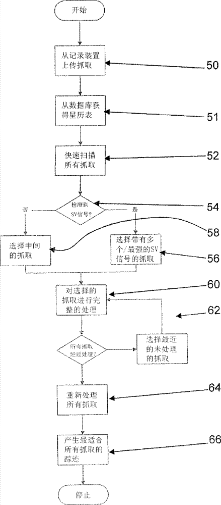
参考图2来说明控制器执行的逻辑。The logic executed by the controller is described with reference to FIG. 2 .
“初始化系统”的步骤30涉及应该选择每个抓取为多长以及抓取之间的周期为多大。
在步骤32中存储一个抓取的GPS IF数据,并且在步骤34中确定下一个抓取的计时。The GPS IF data of one grab is stored in
在步骤36中周期性地测试,以查看用户是否已命令停止数据记录或者是否已到达下一个抓取的时间(步骤38)。当下一个抓取的时间没有到达时,系统处于等待模式,并监测记录是否停止。Periodically test in
步骤40监测是否可以下载数据,并且步骤42涉及针对后续处理的记录抓取向PC的加载。
在这种情况下,PC上的处理将旨在确定装置激活时的移动。这将通过以下方式来实现:对每个抓取进行处理从而检测尽可能多的SV并且针对这些SV尽可能准确地确定码相位/伪距以及多普勒频移。可以将来自每个抓取的这些测量、连同星历表以及其他星座数据下载一起提交给确定GPS位置/速率的计算以确定每个抓取的位置/速率。In this case, the processing on the PC will be aimed at determining the movement of the device upon activation. This will be achieved by processing each grab such that as many SVs as possible are detected and the code phase/pseudorange and Doppler shift are determined as accurately as possible for these SVs. These measurements from each grab, along with ephemeris and other constellation data downloads, can be submitted to a calculation to determine GPS position/velocity to determine the position/velocity for each grab.
但是,可以将所有抓取的测量提交给追踪滤波器(诸如卡尔曼滤波器),已获得更平滑的踪迹。However, it is possible to submit all captured measurements to a tracking filter (such as a Kalman filter) to obtain a smoother track.
在其最简单的方式中,使用提供灵敏度限制的所选长度的集成周期来检测尽可能多的SV涉及对所有的32个SV执行已知的二维编码/载波搜索(例如,参考Understanding GPS-Principles andApplications,Ed.E.D Kaplan,Artech House,Section 5.1.7-ISBN0-89006-793-7)。事实上,使用额外的信息来限制搜索的大小既有助于结果的有效性也有助于结果的可靠性。In its simplest form, detecting as many SVs as possible using an integration period of a chosen length providing a sensitivity limit involves performing a known two-dimensional code/carrier search on all 32 SVs (see, for example, Understanding GPS- Principles and Applications, Ed.E.D Kaplan, Artech House, Section 5.1.7-ISBN0-89006-793-7). In fact, using additional information to limit the size of the search contributes to both the validity and reliability of the results.
可以完全独立地处理每个抓取。但是,本发明建议使用从一个抓取中提取的信息来帮助其他抓取,并且这可以更有效地产生更好的结果。Each fetch can be handled completely independently. However, the present invention proposes to use the information extracted from one crawl to help other crawls, and this can produce better results more efficiently.
例如,给定没有其他信息的单个抓取,则针对所有的32个SV都很可能需要关于每个可能的码相位和载波频率的搜索。需要搜索的载波频率范围的大小取决于GPS前端中振荡器的性质(具有1ppm误差的振荡器导致L1信号的IF中的1.5kHz的误差)和信号的可能的多普勒频移(从地球表面观察的SV通常具有+/-4kHz范围内的多普勒频移,并且接收机的运动可以增大该多普勒频移)。For example, given a single grab with no other information, a search for every possible code phase and carrier frequency would likely be required for all 32 SVs. The size of the carrier frequency range that needs to be searched depends on the nature of the oscillator in the GPS front-end (an oscillator with a 1ppm error results in a 1.5kHz error in the IF of the L1 signal) and the possible Doppler shift of the signal (from the Earth's surface The observed SV typically has a Doppler shift in the +/- 4kHz range, and receiver motion can increase this Doppler shift).
本发明利用一个定位(其将产生卫星时钟的信息)来减少其他定位所需的处理,并且这些处理可以不按照记录采样的顺序。存在许多方法可以简化处理,这些将在下文论述。The present invention utilizes one fix (which will generate satellite clock information) to reduce the processing required for other fixes, and these processes may not be in the order in which the samples are recorded. There are many ways to simplify processing, which are discussed below.
如果将要处理来自几乎同时记录时间戳标示的同一装置的多个抓取,在一个抓取中的SV的检测很可能使得相同的SV在其他抓取中也是可检测的。此外,一旦已知存在一个SV,就可以排除已知的地球另一侧的任意SV。If multiple captures are to be processed from the same device recording timestamps at nearly the same time, detection of an SV in one capture will likely make the same SV detectable in other captures as well. Furthermore, once an SV is known to exist, any known SV on the other side of the Earth can be ruled out.
此外,由于给定SV的载波频率变化相当慢,因此一个抓取中已知的载波频率可以被用于预测暂时靠近(close)的抓取,潜在地限制了将要实现的频率搜索的大小。Furthermore, since the carrier frequency of a given SV changes rather slowly, the known carrier frequency in one grab can be used to predict temporally close grabs, potentially limiting the size of the frequency search to be implemented.
最后,如果可以确定(通过对时间戳进行微分)抓取之间的时间差,再根据可以确定的差值的准确性,可以预测数据信息中的比特边缘的位置或者甚至是一个抓取的码相位、以及可以使搜索更容易和/或更可靠的所有信息。在这种情况下,基于用于驱动前端的同一振荡器的计数循环,时间戳可以提供更好的结果,这是因为该计时可能是高质量的并且可以针对GPS信号对其进行校准。Finally, if the time difference between grabs can be determined (by differentiating the timestamps), then from the accuracy of the difference that can be determined, the position of a bit edge in the data message or even the code phase of a grab can be predicted , and all information that may make searching easier and/or more reliable. In this case, timestamping based on count cycles of the same oscillator used to drive the front-end may give better results, since the timing is likely to be of high quality and it can be calibrated against the GPS signal.
时间戳可以推测先前或随后的计时。如果刚才(或不久后)获得计时,并且已知该计时是准确的,则可以通过计算流逝的时间来尽可能准确地确定正在处理的抓取的时间。一种方法是技术来自A/D转换器的采样,这是因为A/D变换器是由针对GPS时间可以非常准确地校准的好的晶体来驱动的(作为实现速率确定的边界效应)。在这种情况下,很容易实现0.1ppm并且可以实现得更好(这对应于每10秒最多丢失1微秒),即可以容许几分钟或者甚至是几小时的间隔。Timestamps can extrapolate previous or subsequent timings. If the timing was obtained just now (or shortly after), and is known to be accurate, you can time the fetch being processed as accurately as possible by calculating the elapsed time. One way is to use sampling from the A/D converter, since the A/D converter is driven by a good crystal that can be calibrated very accurately for GPS time (as a side effect of achieving rate determination). In this case, 0.1 ppm is easily achieved and better (this corresponds to a loss of at most 1 microsecond every 10 seconds), ie a gap of minutes or even hours can be tolerated.
近似的位置信息也可以用于克服上述计时不确定性。由于无线电信号1毫秒传输约300千米,在150千米的半径内获知位置则完全不会不确定。Approximate location information can also be used to overcome the timing uncertainty described above. Since the radio signal travels about 300 kilometers in 1 millisecond, knowing the position within a radius of 150 kilometers is completely indeterminate.
根据本发明,一旦获得一个抓取的定位,则对抓取组的处理可以使用相对计时和位置估计。因此,该附加信息可以使得更容易消除具有微弱信号的其他抓取的计时不确定性。偶然的附加测量可以谨慎地记录较长的抓取(例如,如果1天记录6秒则不存在抓取,如果间隔大于2小时则记录1秒否则记录100毫秒)According to the present invention, once a fix for a grab is obtained, processing of groups of grabs can use relative timing and position estimates. Thus, this additional information may make it easier to remove timing uncertainty for other grabs with weak signals. Occasional additional measurements can be prudent to record longer grabs (e.g. no grabs if 6 seconds are recorded for 1 day, 1 second if the interval is greater than 2 hours else 100 ms)
图3示出了如何可以执行对记录抓取的处理。Figure 3 shows how the processing of record grabbing may be performed.
在步骤50中的上传数据之后,在步骤51中从数据库中获得星历表数据。这将在下文中论述,并且这减小了需要从接收机上传的数据量。After uploading the data in
在步骤52中,首先使用“对所有抓取的快速扫描”。这涉及使用较短的集成周期(例如1毫秒)在所有抓取中寻找所有可能的SV。这种快速扫描必然只能找出较强的信号(来自清楚地“可见的”SV),而也将需要相对适度的处理能力。In
对给定SV的搜索是在码相位与载波频率的给定范围内执行的。选择被处理的数据量(即,相关集成周期,在该示例中对应于1毫秒),以使可以检测到来自较强卫星信号的编码,所述数据量少于期望获得的较弱信号。通常,为了获得较弱信号应该处理的数据量为上述数据量的至少四倍。The search for a given SV is performed within a given range of code phase and carrier frequency. The amount of data processed (ie the associated integration period, which in this example corresponds to 1 millisecond) is chosen such that codes from stronger satellite signals can be detected than would be expected for weaker signals. Typically, at least four times the amount of data mentioned above should be processed in order to obtain a weaker signal.
对于任意所选可靠度来说,集成周期越长,可以期望检测到越弱的信号。理论上,积分长度加倍则增大3dB的灵敏度,尽管事实上不完全性通常是指没有获得完全的3dB改进。但是,积分长度的加倍即指处理采样的加倍,因此所需的处理能力也(大约)加倍。事实上,在某些情况(例如,相干积分)下,集成周期越长电意味着频率范围越窄,因此所需的处理能力增长甚至更快。For any chosen level of reliability, the longer the integration period, the weaker signals can be expected to be detected. In theory, doubling the integration length increases the sensitivity by 3dB, although in practice incompleteness usually means that the full 3dB improvement is not obtained. However, doubling the integration length means doubling the processing samples and thus (approximately) doubling the required processing power. In fact, in some cases (for example, coherent integration), a longer integration period means a narrower frequency range, so the required processing power grows even faster.
通过示例的方法,可以在可用于使用10毫秒集成周期搜索一个SV的相同处理时间中,使用1毫秒集成周期来处理对所有的32个SV的搜索。1毫秒的仅有的缺点是可能具有约10dB的较小的灵敏度,但是,当视野空旷时,其足可以发现来自高海拔SV的强信号。使用抓取的集合来处理,在具有较少先验知识的情况下,与从开始就是用10毫秒积分相比,如下方式可能更有效:对每个抓取执行32个1毫秒的积分以寻找提供一个或多个(强)SV信号的一个抓取,并且接着使用从该抓取中获得的信息来优化随后10毫秒的积分。By way of example, the search for all 32 SVs can be processed using a 1 millisecond integration period in the same processing time that can be used to search one SV using a 10 millisecond integration period. The only disadvantage of 1 ms is that it may have less sensitivity of about 10 dB, but it is enough to find strong signals from high altitude SVs when the field of view is clear. Using a collection of fetches to process, with less prior knowledge, may be more efficient than integrating 10 ms from the start by doing 32 1 ms integrations for each fetch to find A capture of one or more (strong) SV signals is provided, and the information obtained from this capture is then used to optimize the following 10 ms integration.
如果在步骤54中从快速抓取中检测到了SV,则接着在步骤56中选择具有最强SV信号的抓取以用于进一步的处理。如果没有找到SV,则在步骤58中选择中间的抓取。If in
基于该“快速扫描”的结果,在步骤60中展开更详细和昂贵的处理,其以上述最成功的抓取开始。这给出了从被处理的第一抓取获得位置/速率确定并因此提供用于处理其他抓取的有用信息的最佳机会。Based on the results of this "quick scan", a more detailed and expensive process is carried out in
完整的处理具有更长的积分长度。Full processing has a longer integration length.
如上所述,IF数据的100毫秒的单个抓取其自身不包括足够的信息来计算确定的位置。这是因为,为了确定完整的伪距,必须非常准确地确定信号传输的时间。对信号的检测(即,获得码相位)显示了时间的精细部分(在毫秒内计时),但是由于每毫秒重复一次相同的扩频码,因此也需要时间的粗略的部分(毫秒)。由于计算是基于接收信号来源的多个卫星的相对时延进行的,因此不需要绝对的GPS时间。As mentioned above, a single grab of 100 milliseconds of IF data does not by itself contain enough information to compute a determined position. This is because, in order to determine the full pseudorange, the timing of the signal transmission must be very accurately determined. Detection of the signal (ie, obtaining the code phase) reveals a fine fraction of time (clocked in milliseconds), but also requires a coarse fraction of time (milliseconds) since the same spreading code is repeated every millisecond. Absolute GPS time is not required since the calculations are based on the relative time delays of multiple satellites receiving the signal source.
数据库信息可以帮助解决该不确定性。例如,可以假设数据库记录最近一周每个GPS SV传输的每个数据位(32个SV*50比特每秒*24小时*60分钟*60秒=约17兆字节),则将要处理一个具有时间戳的100毫秒的抓取。该时间戳可具有约1秒的绝对准确性,而具有更大的相对准确性。在一个较短的100毫秒的抓取中可以检测到任意SV的5比特或6比特的式样,并且可以分析这些式样以查看这些式样在2秒(该标称时间中的每1秒允许时间戳存在潜在的不准确性)视窗中在数据库中的匹配次数。该单独的时间戳(即使具有1秒的准确性)可以给出唯一匹配的合理机会,这是因为可以将该绝对时间映射到从存储在数据库中的卫星数据获得的卫星位置的范围。否则,可能性的数量可能非常小。当然,抓取长度越长,式样唯一匹配的可能性越大。Database information can help resolve this uncertainty. For example, it can be assumed that the database records each data bit transmitted by each GPS SV in the last week (32 SVs*50 bits per
传统的GPS接收机通过以下方式来实现全局计时:确定比特边缘(例如,1500比特GPS字的间隔20毫秒的单个比特)的位置,并且接着对数据信息进行数秒的解码,直至可以识别信息的多个部分(诸如子帧前同步信号和/或转换字)。在使用存储并稍后处理系统的情况下,这种持续很久的处理是不可行的。Conventional GPS receivers achieve global timing by locating bit edges (e.g.,
如果时间戳不足,确定比特边缘位置则可能足够。通常,接收机的计时器足够准确以自身提供该级别的信息时不可能的,但是一旦针对一个抓取确定了准确的时间信息,多个抓取之间的差分时间戳则可以给出足够准确的时间。If timestamps are not sufficient, determining bit edge positions may be sufficient. In general, it is not possible for a receiver's timer to be accurate enough to provide this level of information by itself, but once accurate time information has been established for a grab, differential timestamps between multiple grabs can give sufficiently accurate time.
因此,一旦已完全处理了一个抓取,则简化了对随后抓取的处理。不仅将要搜索的码相位的范围可以较窄,而且载波频率搜索也可以较窄(例如,如果2分钟之前以+3265Hz的频率偏移看到了SV2,则在这期间不可能移动太多,因此执行完全的+/-6000Hz的扫描就是浪费的,而执行3265+/-500Hz的扫描可能足够)。Thus, once one grab has been fully processed, the processing of subsequent grabs is simplified. Not only can the range of code phases that will be searched be narrow, but also the carrier frequency search can be narrow (for example, if SV2 was seen 2 minutes ago at a frequency offset of +3265Hz, it is unlikely to have moved much during that time, so perform A full +/-6000Hz sweep is wasteful, while performing a 3265+/-500Hz sweep might suffice).
也可以使用比特式样和/或比特边缘位置的预测,并且接着可以对积分进行计时,以考虑期望的比特边缘位置。Predictions of bit patterns and/or bit edge positions may also be used, and the integration may then be timed to account for expected bit edge positions.
对于给定的积分长度来说,搜索范围(码相位和/或载波频率)越小,搜索的灵敏度/可靠性越大,这是因为看到噪声尖峰的机会越小。因此,针对给定的抓取长度,通过考虑一个完整的处理了的抓取,改进了处理其他抓取(或早或迟)的灵敏度。For a given integration length, the smaller the search range (code phase and/or carrier frequency), the more sensitive/reliable the search is because the chance of seeing noise spikes is less. Thus, for a given grasp length, by considering one complete processed grasp, the sensitivity of processing other grasps (sooner or later) is improved.
如上所述,通过使用来自先前已处理了的抓取的信息,在循环62中依次处理其他抓取。在步骤64中可以对其进行重新处理。这可以包括重新运行完整的与允许搜索范围进一步变窄从而增大灵敏度的更多信息的相关。Additional fetches are processed sequentially in
对于追踪跑步者的示例,在步骤66中产生最适合于抓取的踪迹。For the example of tracking a runner, in step 66 a track best suited for grabbing is generated.
对于跑步者追踪装置具有每10秒一个抓取的示例,可以通过时间戳来测量抓取之间的流逝时间为几微秒。For the example of a runner tracking device having a grab every 10 seconds, the elapsed time between grabs can be measured in microseconds by timestamps.
该方法可以使用多个假设(例如关于时间、位置、载波频率)来提供的对抓取的多次处理。如果处理不能获得定位,则该方法可以使用冷启动类型的方法转而依靠更普通的处理。The method can provide multiple treatments of grabbing using multiple assumptions (eg, about time, location, carrier frequency). If the processing cannot obtain a fix, the method can fall back to more general processing using a cold start type approach.
如上所述,相对时间信息使得可以针对相对延迟值的较窄的范围来执行相关函数,这是因为在较小的边界内已知了码相位。As mentioned above, the relative time information makes it possible to perform the correlation function for a narrow range of relative delay values, since the code phase is known within a small bound.
例如,假设时间t时的给定SV的精确的码相位已知为
1)接收机的时钟不准确。如果使用标准的实时时钟(RTC)电路以及晶体,甚至不能解决感兴趣的微秒时间的区分。但是,如果关于IF数据采样来测量流逝的时间(仅对抓取之间跳过的采样数进行计数),则可以获得源于高质量晶体的精确的分辨率(亚微妙),所述晶体可以针对GPS信号来校准。这导致准确性比0.1ppm更好的计时,即不确定性每10秒流逝时间增长约1微秒。1) The clock of the receiver is not accurate. If standard real-time clock (RTC) circuits and crystals are used, even the microsecond time distinction of interest cannot be resolved. However, if the elapsed time is measured with respect to the IF data samples (just counting the number of samples skipped between grabs), then precise resolution (sub-microsecond) can be obtained from high quality crystals that can Calibrated for GPS signal. This results in timekeeping with an accuracy better than 0.1ppm, i.e. the uncertainty grows by about 1 microsecond for every 10 seconds of elapsed time.
2)由于SV会移动,因此有效的码频率不是刚好1.023MHz。但是幸亏其轨道是已知的,因此可以相当有效地允许该显现,而在大多情况下,这种现象已经无关紧要。2) Since the SV will move, the effective code frequency is not exactly 1.023MHz. But thanks to its known orbit, it allows the manifestation quite effectively, and in most cases the phenomenon is irrelevant.
3)用于也可能移动。因此不能分辨在相同地方间隔20分钟拍摄的两个抓取与在由快速列车连接的两个站台拍摄的两个抓取之间的差别。无线电信号以约300米每微秒的速度移动,因此300米的用户移动约等于一微秒的时钟误差。用户可以输入关于其移动的信息,或者可以使用惯性感测器。例如,用户可以使用“静止/慢速移动/快速移动”的设置来协助处理。3) Used to also possibly move. It is therefore not possible to tell the difference between two captures taken 20 minutes apart in the same place and two captures taken at two platforms connected by an express train. Radio signals move at about 300 meters per microsecond, so a user movement of 300 meters equals about one microsecond of clock error. Users can enter information about their movements, or inertial sensors can be used. For example, users can use the "Still/Slow Move/Fast Move" setting to assist with processing.
如果来自上述所有误差的组合总计小于约500微秒(1毫秒码周期的一半),则可以执行更有效的搜索,这是因为可以从参考点来预测码相位,并且搜索的不确定性有限,而不需要对所有可能的码相位进行盲搜索。If the combined total of the errors from all of the above is less than about 500 microseconds (half the 1 millisecond code period), a more efficient search can be performed because the code phase can be predicted from a reference point and the uncertainty of the search is limited, There is no need to perform a blind search for all possible code phases.
可以采取另外的多个测量来确保能获得确定的计时信息:Several additional measurements can be taken to ensure definitive timing information:
-可以记录偶然的长抓取(至少6秒以覆盖子帧之间的边界)。处理时,这些将包含足够的数据信息部分来确定地获得GPS时间。- Possibility to record occasional long grabs (at least 6 seconds to cover boundaries between subframes). When processed, these will contain enough data information sections to obtain GPS time deterministically.
-如果可以在约100千米内获得位置估计,则无需使用所有SV的相对计时来处理位置的不确定性,所有SV的相对计时可从星历表以及大约时间(约10秒内)的信息导出。- If position estimates are available within ~100 km, there is no need to deal with position uncertainty using relative timing of all SVs, which can be derived from ephemeris and information about time (within ~10 seconds) .
可以使用多普勒测量替代码相位来实现定位计算(如Tampere科技大学的Antti Lehtinen的硕士论文公布了执行该方法的一种方法参见http://math.tut.fi/posgroup/DopplerPositioningwithGPS.pdf)。而这对于大多数的应用来说不可能足够的准确,当大约位置已知时,则其可以为位置估计的基础。Positioning calculations can be implemented using Doppler measurements instead of code phase (e.g. Antti Lehtinen's master thesis at Tampere University of Technology publishes a way to do this see http://math.tut.fi/posgroup/DopplerPositioningwithGPS.pdf) . While this may not be accurate enough for most applications, it can be the basis for a position estimate when the approximate position is known.
可以依次选择多个可能的位置“猜测”,并且可以选择提供最佳匹配的那一个(US 6,417,801中描述了与该方法类似的方法)。Multiple possible position "guesses" can be chosen in turn, and the one that provides the best match can be chosen (a method similar to this is described in US 6,417,801).
如上所述,为了确定定位/定速,必须获得SV的准确的轨道参数及其在卫星上的时钟误差;其通过星历表数据传送。As mentioned above, in order to determine position/velocity, the exact orbital parameters of the SV and its clock error on the satellite must be obtained; this is conveyed through the ephemeris data.
这些参数作为正常数据信息的一部分由SV广播,每30秒重复一次。理论上,可以从大量较短的IF抓取来提取这种数据,但是事实上使一个或多个参考观察站收集这些数据并构成数据库更有效,任意希望处理抓取的PC都可以访问该数据库。显然,由于星历表(以及其他数据)随时间而改变,该数据库需要保留历史数据的存档,并且对于给定的时间(通常星历表的有效时间为4小时,因此仅需要大概的时间感来提取正确的入口)该数据库必须能提供适当的入口。These parameters are broadcast by the SV as part of normal data messages, repeated every 30 seconds. In theory, this data could be extracted from a large number of shorter IF grabs, but in practice it is more efficient to have one or more reference observatories collect this data and form a database that can be accessed by any PC wishing to process the grabs . Obviously, since the ephemeris (and other data) changes over time, the database needs to keep an archive of the historical data, and only needs an approximate sense of time for a given time (usually the ephemeris is valid for 4 hours) to extract the correct entry) the database must be able to provide the appropriate entry.
可以将该数据库封装于可通过某种形式的有线或无线网络(包括因特网)访问的服务器中。还可以提供以下附加特征:The database can be housed in a server accessible through some form of wired or wireless network, including the Internet. The following additional features are also available:
-差分校正,- differential correction,
-改进的健康信息(历史记录,在某些时候可以针对健康的SV来对其进行校正,其不一定与其健康传输时相同),- improved health information (history, at some point it can be corrected for a healthy SV, which is not necessarily the same as when its health was transmitted),
-地貌数据库(提供海拔,其为关于地球表而的位置的函数),使用该数据库可以更可靠/准确地定位,- Geomorphic database (provides elevation as a function of position with respect to the Earth's surface), with which more reliable/accurate positioning is possible,
-增强轨道模型,提供更准确的SV位置和/或更长的有效周期(这种信息很可能直接来源于GPS地球站)。- Enhanced orbital models to provide more accurate SV positions and/or longer validity periods (this information is likely to be derived directly from GPS earth stations).
上述技术可以用于许多应用中。摄像机中集成GPS功能已被广泛研究。拍照同时抓取IF可以用于稍后对照片的位置的确定。该系统可以被用于其它休闲活动,诸如通过对高尔夫回合中的每一击(连同所使用的俱乐部)抓取IF,可记录高尔球赛的回合数。The techniques described above can be used in many applications. The integration of GPS functionality in cameras has been extensively studied. Taking a photo while capturing the IF can be used to determine the position of the photo later. The system can be used for other recreational activities, such as by capturing the IF for each shot (along with the clubs used) in a round of golf, the number of rounds of a golf game can be recorded.
许多变量可用于定位处理。在稍后的时间(例如,当外部电源可用时和/或当到星历表的连接可用时)该处理可以在记录装置中实现。该处理可以在服务器而非用户PC中实现并将结果返回到用户PC。该处理可以在打印机或列印站(尤其对于与照片相关的抓取来说)而非用户PC中实现。Many variables are available for positioning processing. At a later time (for example, when an external power source is available and/or when a connection to the ephemeris is available) this processing can be implemented in the recording device. This processing can be implemented in the server instead of the user PC and the result returned to the user PC. This process can be implemented in the printer or print station (especially for photo related capture) instead of the user PC.
如果使一个或多个抓取足够长而包括所有必须的星历表数据,则可以避免使用数据库。需要子帧1、2和子帧3的大部分内容,以使如果一个抓取恰好捕获15秒,则可以提供所有必须的信息。在最糟糕的情况下(如果该抓取恰好在星历表数据改变时的错误时刻开始,这通常每2小时发生一次)可能需要恰好捕获约45秒。Using a database can be avoided if one or more captures are made long enough to include all necessary ephemeris data. Subframes 1, 2 and most of subframe 3 are needed so that if a capture captures exactly 15 seconds, all necessary information can be provided. In the worst case (if the grab happens to start at the wrong moment when the ephemeris data changes, which usually happens every 2 hours) it may take about 45 seconds to capture exactly.
本发明通常可用于存储和处理GPS系统的大多数形式,不限于上述摄像机和运动的示例。其它示例有宠物追踪、财产追踪、以及安全应用。已结合单一频率的GPS描述了本发明,但是对于其它的GNSS系统(全球导航卫星系统GLONASS,Galileo等)来说是类似的。事实上,通过使用从每个载波捕获IF数据的适当装置,该技术还可以应用于多频率系统。The invention is generally applicable to storing and processing most forms of GPS systems and is not limited to the above examples of cameras and motion. Other examples are pet tracking, property tracking, and security applications. The invention has been described in connection with a single frequency GPS, but is similar for other GNSS systems (GLONASS, Galileo, etc.). In fact, this technique can also be applied to multi-frequency systems by using appropriate means to capture IF data from each carrier.
对于本领域技术人员来说,其它各种变型是显而易见的。Various other modifications will be apparent to those skilled in the art.
Claims (16)
Applications Claiming Priority (3)
| Application Number | Priority Date | Filing Date | Title |
|---|---|---|---|
| EP07111057.1 | 2007-06-26 | ||
| EP07111057 | 2007-06-26 | ||
| PCT/EP2008/058042 WO2009000842A1 (en) | 2007-06-26 | 2008-06-24 | Processing of satellite positioning system signals |
Publications (2)
| Publication Number | Publication Date |
|---|---|
| CN101711368A CN101711368A (en) | 2010-05-19 |
| CN101711368B true CN101711368B (en) | 2013-09-11 |
Family
ID=39865213
Family Applications (1)
| Application Number | Title | Priority Date | Filing Date |
|---|---|---|---|
| CN200880021721.3A Active CN101711368B (en) | 2007-06-26 | 2008-06-24 | Method and system for processing of satellite positioning system signals |
Country Status (7)
| Country | Link |
|---|---|
| US (1) | US8907843B2 (en) |
| EP (1) | EP2162756B1 (en) |
| JP (1) | JP5307129B2 (en) |
| CN (1) | CN101711368B (en) |
| AT (1) | ATE529763T1 (en) |
| TW (1) | TW200912358A (en) |
| WO (1) | WO2009000842A1 (en) |
Families Citing this family (14)
| Publication number | Priority date | Publication date | Assignee | Title |
|---|---|---|---|---|
| JP5453722B2 (en) * | 2008-02-26 | 2014-03-26 | セイコーエプソン株式会社 | POSITIONING SYSTEM, POSITIONING DEVICE, SERVER, AND POSITIONING METHOD |
| US8804551B2 (en) | 2008-08-06 | 2014-08-12 | U-Blox Ag | Location estimation by observing wireless signals |
| EP2339378B1 (en) | 2009-12-17 | 2013-03-20 | u-blox AG | Hybrid satellite positioning receiver |
| EP2530488B1 (en) | 2011-06-01 | 2016-04-13 | u-blox AG | Hybrid satellite positioning with prediction |
| EP2530487B1 (en) | 2011-06-01 | 2014-10-01 | u-blox A.G. | Satellite positioning with assisted calculation |
| EP2574952B1 (en) | 2011-09-30 | 2016-05-11 | u-blox AG | Position Validation |
| EP2674784A1 (en) * | 2012-06-11 | 2013-12-18 | U-blox AG | Satellite positioning with mixed capture-parameters |
| CN103675841A (en) * | 2012-09-05 | 2014-03-26 | 迈实电子(上海)有限公司 | Satellite signal receiver and ephemeris update method thereof |
| IN2013CH03050A (en) * | 2013-07-08 | 2015-09-04 | Accord Software & Systems Pvt Ltd | |
| CN104765043A (en) * | 2015-03-17 | 2015-07-08 | 广东工业大学 | High-integration satellite navigation continuously-operating reference station |
| US11092695B2 (en) * | 2016-06-30 | 2021-08-17 | Faraday & Future Inc. | Geo-fusion between imaging device and mobile device |
| US11595117B2 (en) | 2020-12-30 | 2023-02-28 | Hughes Network Systems, Llc | Timing acquisition method for faster beam, gateway, satellite and inter-network handovers |
| US20240214819A1 (en) * | 2022-12-21 | 2024-06-27 | etherwhere Corporation | Positioning-system-aided data sovereignty, data security, and data authentication |
| CN119814893A (en) * | 2024-11-29 | 2025-04-11 | 中国电信股份有限公司 | Data transmission method, device, electronic device and non-volatile storage medium |
Citations (1)
| Publication number | Priority date | Publication date | Assignee | Title |
|---|---|---|---|---|
| US6449485B1 (en) * | 1999-01-22 | 2002-09-10 | International Business Machines Corporation | Technique for mobile wireless device location |
Family Cites Families (11)
| Publication number | Priority date | Publication date | Assignee | Title |
|---|---|---|---|---|
| US6078290A (en) * | 1998-01-06 | 2000-06-20 | Trimble Navigation Limited | User-controlled GPS receiver |
| US6449486B1 (en) | 1998-05-27 | 2002-09-10 | Polaris Wireless, Inc. | Multiple location estimates in a cellular communication system |
| US6430415B1 (en) | 1999-03-29 | 2002-08-06 | Qualcomm Incorporated | Method and apparatus for locating GPS equipped wireless devices operating in analog mode |
| FI110290B (en) * | 2000-05-30 | 2002-12-31 | Nokia Corp | Procedure for investigating the phase of information and electronic device |
| US6417801B1 (en) | 2000-11-17 | 2002-07-09 | Global Locate, Inc. | Method and apparatus for time-free processing of GPS signals |
| US6882309B2 (en) * | 2001-07-18 | 2005-04-19 | Fast Location. Net, Llc | Method and system for processing positioning signals based on predetermined message data segment |
| US6778135B2 (en) * | 2002-11-18 | 2004-08-17 | Rf Micro Devices, Inc. | GPS Receiver |
| US7327310B2 (en) | 2003-11-07 | 2008-02-05 | Global Locate, Inc. | Method and apparatus for managing time in a satellite positioning system |
| GB0418357D0 (en) * | 2004-08-18 | 2004-09-22 | Koninkl Philips Electronics Nv | Gps receiver and related method and apparatus |
| WO2007078223A1 (en) * | 2006-01-05 | 2007-07-12 | Nordnav Technologies Ab | Spread spectrum software receiver |
| US20070211143A1 (en) * | 2006-03-10 | 2007-09-13 | Brodie Keith J | Systems and methods for prompt picture location tagging |
-
2008
- 2008-06-24 US US12/666,287 patent/US8907843B2/en active Active
- 2008-06-24 EP EP08774265A patent/EP2162756B1/en active Active
- 2008-06-24 AT AT08774265T patent/ATE529763T1/en not_active IP Right Cessation
- 2008-06-24 WO PCT/EP2008/058042 patent/WO2009000842A1/en not_active Ceased
- 2008-06-24 JP JP2010513896A patent/JP5307129B2/en active Active
- 2008-06-24 CN CN200880021721.3A patent/CN101711368B/en active Active
- 2008-06-25 TW TW097123687A patent/TW200912358A/en unknown
Patent Citations (1)
| Publication number | Priority date | Publication date | Assignee | Title |
|---|---|---|---|---|
| US6449485B1 (en) * | 1999-01-22 | 2002-09-10 | International Business Machines Corporation | Technique for mobile wireless device location |
Also Published As
| Publication number | Publication date |
|---|---|
| TW200912358A (en) | 2009-03-16 |
| EP2162756A1 (en) | 2010-03-17 |
| CN101711368A (en) | 2010-05-19 |
| US8907843B2 (en) | 2014-12-09 |
| JP2010531448A (en) | 2010-09-24 |
| EP2162756B1 (en) | 2011-10-19 |
| JP5307129B2 (en) | 2013-10-02 |
| ATE529763T1 (en) | 2011-11-15 |
| WO2009000842A1 (en) | 2008-12-31 |
| US20100171658A1 (en) | 2010-07-08 |
Similar Documents
| Publication | Publication Date | Title |
|---|---|---|
| CN101711368B (en) | Method and system for processing of satellite positioning system signals | |
| US8085884B2 (en) | Method and apparatus for processing satellite positioning system signals to obtain time information | |
| US8184045B2 (en) | Processing of satellite positioning system signals | |
| US8009086B2 (en) | System and method for geo-locating a receiver with reduced power consumption | |
| US20100253578A1 (en) | Navigation data acquisition and signal post-processing | |
| US20100182455A1 (en) | Method and apparatus for tagging digital photographs with geographic location data | |
| US20100328152A1 (en) | Method and apparatus for processing satellite positioning system signals | |
| CN102141626A (en) | Hybrid satellite positioning receiver | |
| US6466164B1 (en) | Method and apparatus for calculating pseudorange for use in ranging receivers | |
| US7782252B2 (en) | System and method for GPS signal acquisition | |
| US8717236B2 (en) | Position signal sampling method and apparatus | |
| US8629801B2 (en) | Event location determination | |
| US20130328720A1 (en) | Satellite Positioning with Mixed Capture-Parameters |
Legal Events
| Date | Code | Title | Description |
|---|---|---|---|
| C06 | Publication | ||
| PB01 | Publication | ||
| C10 | Entry into substantive examination | ||
| SE01 | Entry into force of request for substantive examination | ||
| ASS | Succession or assignment of patent right |
Owner name: U BLOCKX AG Free format text: FORMER OWNER: GEOTATE B. V. Effective date: 20100719 |
|
| C41 | Transfer of patent application or patent right or utility model | ||
| COR | Change of bibliographic data |
Free format text: CORRECT: ADDRESS; FROM: EINDHOVEN CITY, NEITHERLAND TO: 8800, NO.68, COURCHE STREET, THALWIL, SWITZERLAND |
|
| TA01 | Transfer of patent application right |
Effective date of registration: 20100719 Address after: 68 Avenue, 8800, Tulsa, Switzerland Applicant after: Blox AG. U. Address before: Holland and the city. Applicant before: Geotate B. V. |
|
| C14 | Grant of patent or utility model | ||
| GR01 | Patent grant |