CN101692315B - Method for analyzing high precision 4D flight trajectory of airplane based on real-time radar data - Google Patents
Method for analyzing high precision 4D flight trajectory of airplane based on real-time radar data Download PDFInfo
- Publication number
- CN101692315B CN101692315B CN2009100353252A CN200910035325A CN101692315B CN 101692315 B CN101692315 B CN 101692315B CN 2009100353252 A CN2009100353252 A CN 2009100353252A CN 200910035325 A CN200910035325 A CN 200910035325A CN 101692315 B CN101692315 B CN 101692315B
- Authority
- CN
- China
- Prior art keywords
- flight
- aircraft
- model
- point
- time
- Prior art date
- Legal status (The legal status is an assumption and is not a legal conclusion. Google has not performed a legal analysis and makes no representation as to the accuracy of the status listed.)
- Active
Links
- 238000000034 method Methods 0.000 title claims abstract description 54
- 230000008569 process Effects 0.000 claims abstract description 17
- 238000005065 mining Methods 0.000 claims abstract description 4
- 238000004458 analytical method Methods 0.000 claims description 23
- 238000012937 correction Methods 0.000 claims description 19
- 239000000446 fuel Substances 0.000 claims description 16
- 230000005484 gravity Effects 0.000 claims description 15
- 230000033001 locomotion Effects 0.000 claims description 13
- 238000013459 approach Methods 0.000 claims description 10
- 238000006467 substitution reaction Methods 0.000 claims description 10
- 238000012795 verification Methods 0.000 claims description 10
- 230000001133 acceleration Effects 0.000 claims description 9
- 230000009194 climbing Effects 0.000 claims description 9
- 230000010354 integration Effects 0.000 claims description 9
- 239000000203 mixture Substances 0.000 claims description 9
- 230000007423 decrease Effects 0.000 claims description 8
- 238000009825 accumulation Methods 0.000 claims description 6
- 230000033228 biological regulation Effects 0.000 claims description 6
- 230000000694 effects Effects 0.000 claims description 6
- 238000012545 processing Methods 0.000 claims description 4
- 230000008878 coupling Effects 0.000 claims description 3
- 238000010168 coupling process Methods 0.000 claims description 3
- 238000005859 coupling reaction Methods 0.000 claims description 3
- 238000007405 data analysis Methods 0.000 claims description 3
- 230000010006 flight Effects 0.000 claims description 3
- 238000009434 installation Methods 0.000 claims description 3
- 230000000630 rising effect Effects 0.000 claims description 3
- 238000012163 sequencing technique Methods 0.000 claims description 3
- 230000002123 temporal effect Effects 0.000 claims description 3
- 230000001105 regulatory effect Effects 0.000 claims description 2
- 230000035945 sensitivity Effects 0.000 abstract 1
- 238000001914 filtration Methods 0.000 description 6
- 238000010586 diagram Methods 0.000 description 3
- 239000000243 solution Substances 0.000 description 3
- 230000007704 transition Effects 0.000 description 3
- 230000009471 action Effects 0.000 description 2
- 239000002585 base Substances 0.000 description 2
- 230000008901 benefit Effects 0.000 description 2
- 238000006243 chemical reaction Methods 0.000 description 2
- 238000001514 detection method Methods 0.000 description 2
- 230000003993 interaction Effects 0.000 description 2
- 238000007726 management method Methods 0.000 description 2
- 230000004048 modification Effects 0.000 description 2
- 238000012986 modification Methods 0.000 description 2
- 238000002715 modification method Methods 0.000 description 2
- NAWXUBYGYWOOIX-SFHVURJKSA-N (2s)-2-[[4-[2-(2,4-diaminoquinazolin-6-yl)ethyl]benzoyl]amino]-4-methylidenepentanedioic acid Chemical compound C1=CC2=NC(N)=NC(N)=C2C=C1CCC1=CC=C(C(=O)N[C@@H](CC(=C)C(O)=O)C(O)=O)C=C1 NAWXUBYGYWOOIX-SFHVURJKSA-N 0.000 description 1
- 230000003044 adaptive effect Effects 0.000 description 1
- 238000003556 assay Methods 0.000 description 1
- 239000003637 basic solution Substances 0.000 description 1
- 230000009286 beneficial effect Effects 0.000 description 1
- 230000015572 biosynthetic process Effects 0.000 description 1
- 238000004364 calculation method Methods 0.000 description 1
- 230000008859 change Effects 0.000 description 1
- 230000000295 complement effect Effects 0.000 description 1
- 238000007418 data mining Methods 0.000 description 1
- 230000007812 deficiency Effects 0.000 description 1
- 238000011161 development Methods 0.000 description 1
- 230000018109 developmental process Effects 0.000 description 1
- 238000005516 engineering process Methods 0.000 description 1
- 230000007613 environmental effect Effects 0.000 description 1
- 239000012467 final product Substances 0.000 description 1
- 230000004927 fusion Effects 0.000 description 1
- 239000011159 matrix material Substances 0.000 description 1
- 238000012827 research and development Methods 0.000 description 1
- 230000009183 running Effects 0.000 description 1
- 238000005070 sampling Methods 0.000 description 1
- 230000011218 segmentation Effects 0.000 description 1
- 238000000528 statistical test Methods 0.000 description 1
- 230000009885 systemic effect Effects 0.000 description 1
- 238000012360 testing method Methods 0.000 description 1
Images


Landscapes
- Traffic Control Systems (AREA)
- Navigation (AREA)
Abstract
The invention discloses a method for analyzing high precision 4D flight trajectory of an airplane based on real-time radar data, comprising the following steps: establishing a 4D fight trajectory theoretical model based on the airplane performance; establishing a 4D fight trajectory empirical model by mining and analyzing based on the historical fight trajectory data of the airplane types in the above step; combining the theoretical model and the empirical model and quantizing various influencing factors in the flight process into adjustable parameters; and correcting the 4D flight trajectory mixed models by radar data to form the final flight trajectory of the airplane. The invention takes the airplane performance into consideration and establishes the theoretical model by performance library parameters on the basis of a standard flight procedure, thus having high reliability; the invention forms the empirical model by analyzing the historical data, thus having high reality; the invention generates the 4D flight trajectory most similar to the actual flight and can adjust the parameters to form a plan trajectory aiming at the environment of each flight, thus high sensitivity; and the invention correct the plan trajectory by introducing the real-time radar data, thus having high accuracy.
Description
Technical field
The present invention relates to a kind of Air Traffic Control Automation System and flight flow management system, the high precision 4D based on real-time radar data of the flight planning track analysis that particularly a kind of real-time acquisition is accurate, continuous, level and smooth (four dimension) aircraft track analytical approach of being used for.
Background technology
At present, in the traffic control automated system aloft, the analytical approach of flight path mainly contains three kinds of great-circle track analysis and isogonism track analysis method, adaptive Kalman filter (Kalman) algorithm and interaction multi-model (IMM) algorithms, all is following position and the time by way point of analyzing in-flight in real time.
Great-circle track is analyzed and isogonism track analysis method, belongs to dynamic track analysis method, is applicable to air route and the termination environment course line of advancing to leave the theatre respectively.But under short-range situation, (as the distance of the great-circle track between Beijing and the Lhasa is 1380 nautical miles for great-circle track distance and isogonism track distance approximately equal, the isogonism track distance is 1386.3 nautical miles), therefore for convenience of calculation, adopt the isogonism track analysis usually.The aircraft of setting flight when analyzing uses following speed variation rule in addition: be to do with cruise speed to fly at a constant speed on the air route, do even decelerating flight on (the advancing near) course line of marching into the arena, do the even flight of quickening on the course line of leaving the theatre.Information such as the current location that provides according to real-time radar data, time, speed are obtained and following way point distance, and then were analyzed the way point time.
Kalman filtering algorithm (Kalman) is a kind of application algorithm very widely, and the criterion of filtering and analysis is the root-mean-square error minimum.Since it can based target motor-driven and observation noise Automatic Model Selection gain sequence, and can automatically adapt to the variation of testing process, can measure the precision of estimating easily by covariance matrix, by residual error (new breath wherein, be the poor of an observed reading and a step assay value) vectorial variation, can judge whether the object module of former supposition and the kinetic characteristic of realistic objective meet, and with this as a kind of means of motor-driven detection and motor-driven identification etc., therefore, it has obtained good development and application at trajectory analysis with in following the tracks of.
More than two kinds of algorithms all be method at single model, be that each has only a model in action constantly, the shortcoming of these methods is when object model is changed saltus step to take place, and causes motor-driven detection hysteresis or estimation analysis precision are not reached higher requirement.
Interaction multi-model algorithm (IMM), application in civil aviaton also is in the research and development, it is that a plurality of wave filter parallel runnings that are complementary with model are arranged simultaneously with the key distinction of in the past filtering algorithm, renewal by Markov chain and new breath implementation model probability reaches the requirement of the soft conversion of model.And in algorithm in the past, though also use the different motion state of the corresponding targets of different models, each has only a model filtering device in action constantly usually, according to statistical test dbjective state is monitored between the different model filtering devices and switches.The multi-model algorithm is a kind of recursive algorithm, the corresponding different process noise level of each model, promptly corresponding a kind of motion model.
And the IMM model algorithm is to move a plurality of models each moment simultaneously, it has solved the above two uncontinuities when model conversion, but the model number is fixed in this method, model description is constant, just structure is changeless, this causes unnecessary calculated amount to increase with regard to making the performance of algorithm not necessarily obviously improve with the increase of the number of model on the contrary.
Make a general survey of existing track analysis algorithm, the current motion state with the flight object is that basic point has been set up motion model mostly, the correction problem of also having considered real-time radar data that has, but weak point is all arranged separately.1, analysis precision is low, though dynamically plan way point information has been considered in track analysis, adopted dynamic data to revise in real time, but, do not consider the flight performance data of flight object, the 4D track analysis model idealization of setting up adopts the velocity amplitude of supposition to analyze again, causes analysis precision to reduce; 2, the analysis period is long more, analytical error is big more, Kalman filtering algorithm and IMM algorithm all are to be observation station with the real motion state, but with the complete renunciation of flight planning, do not consider the to fly performance of object, and can only estimate the value in a following sampling period each time, along with the growth of analytical cycle, error is increasing.
Summary of the invention
Goal of the invention: technical matters to be solved by this invention is at the deficiencies in the prior art, provide on a kind of basis based on flight planning, aircraft performance parameter, historical flying quality, utilize real-time radar data that the flight planning flight path is analyzed, promptly have orientation, distance, highly, the method for analyzing high precision 4 D flight trajectory of airplane based on real-time radar data of the flight aircraft movement locus of information such as speed, time.。
Technical scheme: the invention discloses a kind of method for analyzing high precision 4 D flight trajectory of airplane based on real-time radar data, this method may further comprise the steps:
Step (1) is set up the 4D flight path theoretical model based on aeroplane performance;
Described foundation may further comprise the steps based on the 4D flight path theoretical model of aeroplane performance:
Step (a) is extracted flight planning information, spatial domain information and model-performance parameter: described flight planning information comprises flight number, type, E.T.D(estimated time of departure), the landing airport; Described spatial domain information comprises standard mission program, course line, air route, at advance the to leave the theatre course line and the restriction of various spatial domain on landing airport; Described model-performance parameter comprises the performance data of type correspondence, and promptly aircraft basis geometric parameter, aircraft basic motive mathematic(al) parameter comprise that lift coefficient, resistance coefficient and the climb rate, aircraft configuration information comprise the industry dead weight capacity of aircraft and center of gravity, engine parameter, speed envelope curve, fuel consume;
Step (b) is set up the horizontal model of aircraft track:
Utilize flight planning information, spatial domain information in the step (a), advance departure procedure information, for each flight determine its flight the course line, air route, determine its approach course and the course line of leaving the theatre, thereby form the complete horizontal flight flight path of certain flight;
Step (c) is set up the aircraft track vertical mould:
Utilize step (a) in model-performance information set up the motion model of the climbing of aircraft, decline and air route flight, and be incorporated into departure procedure and carry out the flight path constraint, form the vertical flight flight path of certain complete flight;
Step (d) with aircraft the horizontal range s of process be basic parameter, in cross track model that step (b) and step (c) are set up and path in elevation model, find corresponding 2 points respectively, promptly in the cross track model, represent aircraft to be the some p1 of s from the beginning horizontal flight distance of taking off, and in the path in elevation model, represent aircraft to be the some p2 of s from the beginning horizontal flight distance of taking off, two spot correlations are joined, obtain latitude and longitude coordinates and the height of p2 and the flight time at that time of p1 respectively, form 4D volume coordinate point, thereby form 4D flight path theoretical model based on aeroplane performance;
The described horizontal model of aircraft track of setting up may further comprise the steps:
Step (a) definition cross track, from the plan information of landing airport, Standard Instrument Approach and/or leave the theatre course line and air route information, cruising altitude extract aircraft by way of way point and leap height, set up three-dimensional flight track framework, cross track promptly through the projection line of way point at surface level;
The air route and the course line of advancing to leave the theatre are made of a series of air routes landmark point, are WP with the sequence definition of putting
i, number is n, determines radius of turn r according to flying speed
i, definition constrained type type
i: initial point constraint, general point constraint and terminal constraint, simplified model is:
G
f={wp
1(x
1,y
1,type
1,r
1),…,wp
i(x
i,y
i,type
i,r
i),…,wp
RPn(x
RPn,y
RPn,type
RPn,r
RPn)};
Step (b) is handled turning point, if the initial point constraint is then flown nonstop to down a bit; Turn Models is considered in the general point constraint; The necessary line up with runway of head when end is constrained to aircraft through this; According to the above constraint, structure comprises radius of turn r, the Turn Models of turning point P, Q coordinate:
Radius of turn
 G is an acceleration of gravity, and flying speed is v during turning, and the pitch angle is φ; The course angle of aircraft flight is with reference to zero degree with direct north, increases along clockwise direction, is 359 degree to the maximum; Use α
12The course angle of representing last leg, α
23The course angle of one leg, expression back according to 3 line relation, judges that aircraft is to turn left, turn right or fly nonstop to; In conjunction with the course angle of two sections flights with turn to, obtain aircraft turning angle Δ α; According to turning angle and radius of turn, obtain the distance of P point-to-point i: D
P, i=r * tan (Δ α/2), the coordinate that draws turning point P is:
G is an acceleration of gravity, and flying speed is v during turning, and the pitch angle is φ; The course angle of aircraft flight is with reference to zero degree with direct north, increases along clockwise direction, is 359 degree to the maximum; Use α
12The course angle of representing last leg, α
23The course angle of one leg, expression back according to 3 line relation, judges that aircraft is to turn left, turn right or fly nonstop to; In conjunction with the course angle of two sections flights with turn to, obtain aircraft turning angle Δ α; According to turning angle and radius of turn, obtain the distance of P point-to-point i: D
P, i=r * tan (Δ α/2), the coordinate that draws turning point P is:
The Q point coordinate is:
Final cross track mark is made up of a series of orderly points:
G
f={wp
1(x
1,y
1),…,P
i(x
i,y
i),Q
i(x
i,y
i),…,wp
RPn(x
RPn,y
RPn)};
The described aircraft track vertical mould of setting up may further comprise the steps:
Step (a) is divided the paragraph of flight path in elevation model, according to five stages of flight: take off, climb, flatly fly, descend, land, whole path in elevation computation model is divided into the calculating that five submodels are handled above-mentioned five paragraphs respectively;
Step (b) is determined flight path in elevation model basic parameter, described vertical mould be aircraft in height-time or height-range coordinate system motion model, definite effect external force aboard: motor power F, direction becomes engine installation angle lift L perpendicular to flying speed v along engine axis with fuselage axis X-shaped; Resistance D is parallel to flying speed; Gravity G is downward; α is the angle of attack, and θ is a flight-path angle; The method that adopts Newton second law and conservation of energy principle to combine is listed the submodel equation of each inflight phase correspondence, use imfinitesimal method and divided the segment of some five equilibriums each stage, the substitution aircraft is in the performance parameter of each stage correspondence, find the solution the rising/rate of descent of every segment, corresponding distance and time, adding up at last forms altitude profile and velocity profile, and obtains flight time accumulation;
Step (c) is determined the model of the sliding race process of takeoff phase:
The sliding race process of takeoff phase, sliding speed is parallel to surface level, the friction force f of tire and runway face;
Sliding the kinetics equation of race stage foundation along runway heading:

Wherein μ is the runway friction factor, and m is an aircraft weight, and g is an acceleration of gravity,
 Be percentage speed variation,
Be the runway gradient, gravity component in the horizontal direction:
Be percentage speed variation,
Be the runway gradient, gravity component in the horizontal direction:


In the starting heats stage, aircraft angle of attack is assumed to the shutdown angle of attack, draws acceleration a, with given flying speed V
LOFThe substitution formula:

 Adopt numerical integrating to slide and sue for peace after the race section is divided into the independent integration of segment, draw ground roll-out distance and sliding race time;
Step (d) is determined aerial each inflight phase model:
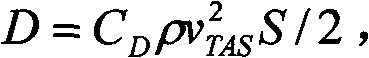
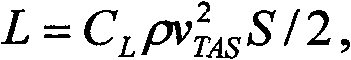
In all stages after liftoff before land, use equation:

Wherein h is an aircraft place height, v
TASBe the flight true air speed; In the top formula

 Described C
DAnd C
LBe given resistance coefficient of aeroplane performance parameter and lift coefficient, ρ is an atmospheric density, and S is a wing area;
Described C
DAnd C
LBe given resistance coefficient of aeroplane performance parameter and lift coefficient, ρ is an atmospheric density, and S is a wing area;
According to the thrust magnitude of ramp-up period correspondence, obtain escalating rate, obtain the used time behind certain height that rises with numerical integration; Obtain percentage speed variation, binding time and percentage speed variation are obtained the horizontal range of every segment; Add the fuel consume coefficient, obtain the amount of fuel that per stage consumes, every segment weight is constant in approximate thinking, following a bit of weight is that the preceding paragraph weight deducts amount of fuel; Result's summation of every segment is obtained time, distance, the speed of ultimate demand;
Cruising phase adopts equal altitudes and waits the Mach number mode to carry out; Stipulated most economical cruise speed or Mach number in the described aeroplane performance parameter, used kinematical equation and obtain cruise time, distance, amount of fuel; Aircraft drops to specified altitude assignment with the maximum gliding angle of regulation, obtains voyage and time;
The performance parameter of substitution decline stage correspondence is obtained rate of descent, obtains the used time by integration; Obtain percentage speed variation, binding time is obtained distance, has formed the vertical mould of whole airflight;
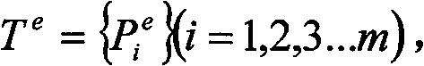
Step (2) based on the historical flight path data of aircraft model in the step (1), is set up 4D flight path empirical model by mining analysis;
Described step (2) during to the comprehensive flight path output information of control automated system and implementing plan corresponding weather information carry out the admission of certain hour, these data are put in order as data source;
Specifically may further comprise the steps:
Step (a) generates the experience flight path:
The comprehensive output information of every frame of district's guard system output is a collection of aerial target status information and following desired track information at that time; By playing the historical comprehensive output information of a period of time, Frame is contrasted one by one, flight path by flight number, landing airport, actual time of departure, type and flight path information number all is encapsulated in this flight object set as the sign of unique object position sequence, height sequence, the time corresponding sequence with whole flight course, promptly forms the historical track of flight; To same flight object, in the repeatedly flight of a period of time, the object set that encapsulates has a plurality of, and a plurality of historical tracks are promptly arranged:
T(obj,i)={x
j,y
j,h
j,t
j,v
j}(i=(1,2,…,n),j=(1,2,…,m));
Wherein obj is the flight object, and n is the flight total degree, and equation the right is position, time, the velocity information of each tracing point, and m is the tracing point number of each flight path; To a plurality of track set of each flight object,, draw the experience track of this object with every data difference weighted; Processing procedure comprises parameter alignment and weighted;
Described parameter is aligned to a plurality of track set to same target, comprise and calculate the distance between first tracing point and original base in each set, starting point in the big set of selected distance is as the position reference point, point in other set before this position is rejected, and forms approximate unified origin information; The time of all starting points is located zero point, the time sequencing skew of back tracing point;
Described weighted is to single object, comprise with the position in a plurality of historical tracks set after the parameter alignment, time, speed respectively weighted draw the experience track of this object;
Step (b) is handled the upper-level winds meteorology:
Described weather data analysis comprises: a GRIB message comprises the upper-level winds information in the territory, eighth of the earth, each height layer sends a message, according to the GRIB message format historical data is resolved, obtain temperature, wind direction and the wind speed of certain location point upper-level winds; According to the experience track of certain object, the weather information of each tracing point of coupling comprises on the way wind direction and wind speed in weather data; These data are kept in the community set of this object;
Step (3), the empirical model that theoretical model that step (1) is obtained and step (2) obtain combines, various influence factors in the flight course are quantized to become adjustable parameter, promptly obtain an accurate 4D flight path mixture model of considering the extraneous factor variation based on aeroplane performance again;
Accurate 4D flight path mixture model carries out verification and supplementary parameter to the described theoretical model of step (1) in the described step (3);
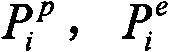
Described verification comprises time error and space error verification;
If theoretical flight path is
Wherein n is the prediction track points number of theoretical flight path;
And the experience flight path is
 Wherein m is the prediction track points data of experience flight path;
Get m=n;
Wherein
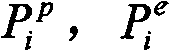 All be space-time four-dimentional space point, promptly contain { x, y, z, t} 4-coordinate;
Then the unit interval error is:
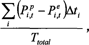 Δ t wherein
iBe the timeslice length between two track points, T
TatalBe flight time accumulation; The unit space error is:
Δ t wherein
iBe the timeslice length between two track points, T
TatalBe flight time accumulation; The unit space error is:
 Δ s wherein
iBe the spatial pieces length between two track points, S
TatalBe total distance of flying;
Δ s wherein
iBe the spatial pieces length between two track points, S
TatalBe total distance of flying;
Described supplementary parameter comprises: takeoff speed
 I=1 wherein, 2,3...n, j=1,2,3 ... m; M is the section of the taking off track points number of definition, and n is the flight path number; Control intention, control intention comprise horizontal control intention and vertical control intention; Level is intended that the formed actual flight path Control Node of flight paragraph of standoff on cross track, comprises that flight path deflects away from a little, flight path virtual navigation point sequence, flight path reentry point; Vertically be intended that the rise and fall control command of on vertical section, carrying out, comprise and highly regulate starting point, highly regulate terminating point, escalating rate or rate of descent; Average escalating rate is obtained by the weighted mean of the escalating rate of ascent stage; Average rate of decrease: the weighted mean by the rate of descent of descending branch is obtained; Weather data, wind speed on the way that historical analysis is obtained and the speed in the experience track are asked phasor difference, this difference is added adjustment factor add to speed term in the theoretical model, and basis meteorology is at that time regulated this coefficient taking off before;
Step (4) with the described 4D flight path of radar data correction mixture model, forms final aircraft flight flight path.
The flight path of 4D described in the present invention be have orientation, distance, highly, the flight aircraft movement locus of information such as speed, time.
Beneficial effect: the invention has the advantages that: at first, the present invention has considered the performance of aircraft, on the basis of standard mission program, has set up theoretical model with performance library parameters, this model and flight to as if be closely connected, reliable with respect to existing processing; The second, the present invention analyzes historical data, has formed the model of experience, and is relatively truer comparatively speaking; The 3rd, will integrate theory with practice, produce 4D track, and can regulate the formation desired track to parameter at the environment of each flight near Live Flying, relatively sensitiveer; At last, introduce real-time radar data desired track is revised, make the desired track accuracy improve.
Description of drawings
Below in conjunction with the drawings and specific embodiments the present invention is done further to specify, above-mentioned and/or otherwise advantage of the present invention will become apparent.
Fig. 1 is the method for analyzing high precision 4 D flight trajectory of airplane process flow diagram that the present invention is based on real-time radar data.
Fig. 2 sets up process flow diagram for 4D track analysis among the present invention.
Fig. 3 calculates synoptic diagram for point of contact, aircraft turning angle in the Turn Models among the present invention.
Fig. 4 is effect main external force aboard in the aircraft longitudinal movement process among the present invention.
Embodiment:
As depicted in figs. 1 and 2, the invention discloses a kind of method for analyzing high precision 4 D flight trajectory of airplane based on real-time radar data, this method may further comprise the steps:
Step (1) is set up the 4D flight path theoretical model based on aeroplane performance;
Step (2) based on the historical flight path data of aircraft model in the step (1), is set up 4D flight path empirical model by mining analysis;
Step (3) combines theoretical model and empirical model, and the various influence factors in the flight course are quantized to become adjustable parameter, promptly obtains an accurate 4D flight path mixture model of considering the extraneous factor variation based on aeroplane performance again;
Step (4) with the described 4D flight path of radar data correction mixture model, forms final aircraft flight flight path.
Particularly, the present invention comprises following content:
1, based on the 4D modelling of aeroplane performance
1.1 data are prepared
Set up accurate 4D flight path theoretical model, the information that relates to has:
1) flight planning information comprises flight number, type, E.T.D(estimated time of departure), landing airport etc.
2) spatial domain information, standard mission program, course line, air route and at the course line of advancing to leave the theatre on landing airport.
3) model-performance parameter, the performance data of type correspondence, this is that theoretical model is set up main factor, comprises aircraft basis geometric parameter, aircraft basic motive mathematic(al) parameter (lift coefficient, resistance coefficient, the climb rate), aircraft configuration information (industry dead weight capacity, center of gravity), engine parameter, speed envelope curve, fuel consume.
1.2 cross track model algorithm
Flight f is made up the 4D track, at first plan information is handled: at first according to landing airport and settle the standard instrument leave the theatre course line SID (StandardInstrument Departure) and Standard Instrument Approach course line STAR (Standard Terminal ArrivalRoute) of the course line distribution principle of advancing to leave the theatre of airport correspondence separately, secondly according to constraint condition refinements such as air route information, cruising altitude by way of way point and leap height, preliminary set up three-dimensional flight path framework, and cross track be exactly through the projection of way point at surface level.Here the cross track of obtaining only is a plan position information, and the temporal information of location point must be calculated after obtaining velocity profile.
The air route and the course line of advancing to leave the theatre all are to be made of a series of air routes landmark point, are WP with the sequence definition of putting
i, number is n, determines radius of turn r according to flying speed
i, and definition constrained type type
i: initial point constraint, general point constraint and terminal constraint, simplified model is:
G
f={ wp
1(x
1, y
1, type
1, r
1) ..., wp
i(x
i, y
i, type
i, r
i) ..., wp
RPn(x
RPn, y
RPn, type
RPn, r
RPn) formula (1)
If the initial point constraint is then flown nonstop to down a bit; The general point constraint will be considered Turn Models; Terminal constraint is exactly that head must line up with runway during through this for aircraft.According to various constraints, it is as follows to make up Turn Models:
Radius of turn
 G is an acceleration of gravity, and flying speed is v during turning, and the pitch angle is φ.As Fig. 3, the coordinate of known adjacent three way points and corresponding radius of turn r obtain turning point P, the Q coordinate gets final product.The course angle of aircraft flight is with reference to zero degree with direct north, increases along clockwise direction, is 359 degree to the maximum.Use α
12The course angle of representing last leg, α
23The course angle of one leg, expression back according to 3 line relation, judges that aircraft is to turn left, turn right or fly nonstop to; In conjunction with the course angle of two sections flights with turn to, obtain aircraft turning angle Δ α; According to turning angle and radius of turn, obtain the distance of P point-to-point i: D
P, i=r * tan (Δ α/2), the coordinate that draws turning point P is:
G is an acceleration of gravity, and flying speed is v during turning, and the pitch angle is φ.As Fig. 3, the coordinate of known adjacent three way points and corresponding radius of turn r obtain turning point P, the Q coordinate gets final product.The course angle of aircraft flight is with reference to zero degree with direct north, increases along clockwise direction, is 359 degree to the maximum.Use α
12The course angle of representing last leg, α
23The course angle of one leg, expression back according to 3 line relation, judges that aircraft is to turn left, turn right or fly nonstop to; In conjunction with the course angle of two sections flights with turn to, obtain aircraft turning angle Δ α; According to turning angle and radius of turn, obtain the distance of P point-to-point i: D
P, i=r * tan (Δ α/2), the coordinate that draws turning point P is:
The Q point coordinate is:
Final horizontal trajectory is made up of a series of orderly points:
G
f={ wp
1(x
1, y
1) ..., P
i(x
i, y
i), Q
i(x
i, y
i) ..., wp
RPn(x
RPn, y
RPn) formula (2)
1.3 path in elevation model algorithm
According to most typical five stages of flight: take off, climb, flatly fly, descend, land, we also are divided into the calculating that five submodels are handled above-mentioned five paragraphs respectively with whole path in elevation computation model accordingly.At each paragraph, the method that its submodel adopts Newton second law and conservation of energy principle to combine is listed equation, use infinitesimal knowledge and divided the segment of some five equilibriums each stage, the substitution aircraft is in the performance parameter of each stage correspondence, find the solution the rising of every segment or rate of descent, corresponding distance and time, adding up at last forms altitude profile and velocity profile, and obtains flight time accumulation.
Vertical mould mainly characterizes the lengthwise movement of aircraft, this process effect main external force such as Fig. 4 aboard: motor power F, direction becomes engine installation angle lift L perpendicular to flying speed v along engine axis with fuselage axis X-shaped, resistance D is parallel to flying speed, gravity G is downward, α is the angle of attack, and θ is a flight-path angle.The sliding race process of takeoff phase, sliding speed is parallel to surface level, and will consider the friction force f of tire and runway face.
Use the kinetics equation of Newton second law foundation in the sliding race stage along runway heading:

Wherein μ is the runway friction factor, and m is an aircraft weight, and g is an acceleration of gravity,
Be percentage speed variation,
 Be the runway gradient, be worth very little so gravity component in the horizontal direction
 All stages after liftoff before land, but binding kinetics and conservation of energy principle are set up equation:
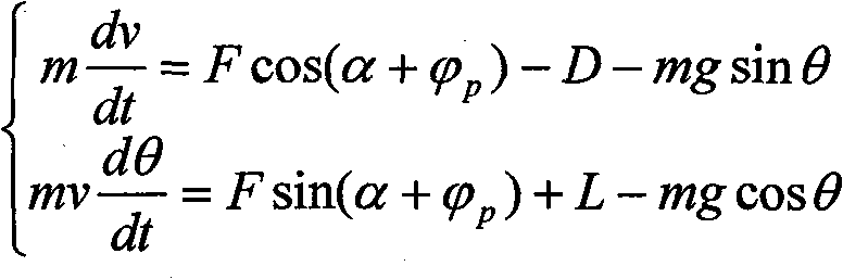
Wherein h is an aircraft place height, v
TASBe the flight true air speed.Above mention in all formula
 C
DAnd C
LBe given resistance coefficient of aeroplane performance parameter and lift coefficient, ρ is an atmospheric density, and S is a wing area.
C
DAnd C
LBe given resistance coefficient of aeroplane performance parameter and lift coefficient, ρ is an atmospheric density, and S is a wing area.
In the starting heats stage, fuel consume can think that seldom aircraft weight is approximate constant, and aircraft angle of attack is assumed to the shutdown angle of attack, so C
DAnd C
LCan think and immobilize.The flight performance parameter substitution formula (3) of this stage correspondence is obtained acceleration a, with given flying speed V
LOFThe substitution formula:
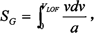 For improving precision, utilize numerical integrating to slide and sue for peace after the race section is divided into the independent integration of segment, draw ground roll-out distance and sliding race time.
(airbus flight operation is supported and the customer service of course line assistance portion according to reference " grasp aeroplane performance ", in January, 2002, http://www.docin.com/p-5457290.html) description, the standard section that climbs comprises: quicken to climb to from departing and specify indicated airspeed V1; Etc. the indicated airspeed specified altitude assignment H1 (being generally 10000 feet) that climbs; Put down and fly to accelerate to indicated airspeed V2; Etc. the indicated airspeed transition altitude H2 (this is highly located corresponding flight Mach number and equates with the true air speed of aircraft) that climbs; At last to wait Mach number cruising altitude of climbing.V1 wherein, V2, H1, the corresponding every kind of type of H2 can be from reference obtains in the tables of data (this partial data also is included in the performance parameter) of various type correspondences.From the type section regulation as can be seen, each segment that climbs has all provided concrete initial and stop value, be exactly and the starting condition of next section of end condition of the last period, so every section the free and distance of institute is calculated in segmentation, Zong last addition is with regard to T.T. and distance for the whole section of climbing.With the performance parameter formula (5) of ramp-up period correspondence, obtain escalating rate, obtain the used time behind certain height that rises with numerical integration.Utilize formula (4) to obtain percentage speed variation again, binding time and percentage speed variation are obtained the horizontal range of every segment.Consider the fuel consume coefficient, obtain the amount of fuel that per stage consumes, every segment weight is constant in approximate thinking, following a bit of weight is that the preceding paragraph weight deducts amount of fuel.At last, result's summation of every segment is obtained time, distance, the speed of ultimate demand.Certainly the Duan Yue that divides is many, and precision is high more.
The climb flight course of section of standard decline section and the standard of describing in this data is just in time opposite, at first to wait Mach number to drop to transition altitude, again with etc. indicated airspeed drop to the appointment approach altitude, then level decelerates to the regulation velocity of approach, slows down at last and lands.The same with climbing, the parameter that relates to all has regulation.Equally, utilize formula (5) to obtain rate of descent, obtain the used time by integration, utilize formula (4) to obtain percentage speed variation again, binding time is obtained distance.
Cruising phase is fairly simple, adopts equal altitudes substantially and waits the Mach number mode to carry out.Stipulated most economical cruise speed or Mach number in the performance parameter, directly used kinematical equation and just can obtain cruise time, distance, amount of fuel.But when this stage runs into course change, need the transition altitude layer, because the division of spatial domain height layer is relevant with the thing course.At this moment require aircraft to drop to specified altitude assignment, obtain voyage and time with the maximum gliding angle of regulation.
1.44D flight path is comprehensive
According to from liftoff to landing the horizontal model and the vertical mould of whole flight course, with aircraft the horizontal range s of process be basic parameter, can in cross track model of setting up and path in elevation model, find corresponding 2 points respectively.Promptly in the cross track model, represent aircraft to be the some p1 of s, and in the path in elevation model, represent aircraft to be the some p2 of s from the beginning horizontal flight distance of taking off from the beginning horizontal flight distance of taking off.With such two spot correlations connection, latitude and longitude coordinates and the height of p2 and the flight time at that time of obtaining p1 respectively, form 4D volume coordinate point.So just can set up out a complete 4D flight path.
2, the 4D experience track that excavates based on historical data
Corresponding weather information (GRIB message) is carried out for a long time the admission of (can be month or a year or longer) during at first to comprehensive flight path output information of control automated system (this paper adopts the main DOD information with system's output of present district pipe) and implementing plan, and these data are put in order as data source.
2.1 the experience track excavates
Every frame DOD information of district's guard system output is a collection of aerial target status information and following desired track information at that time.By playing the historical DOD information of a period of time (such as one month), Frame is contrasted one by one, flight path by flight number, landing airport, actual time of departure (form is the date Hour Minute Second), type and flight path information number all is encapsulated in this flight object set as the sign of unique object position sequence, height sequence, the time corresponding sequence with whole flight course, promptly forms the historical track of flight.To same flight object, in a period of time (such as one month), have repeatedly flight, so that the object set that encapsulates has is a plurality of, a plurality of historical tracks are arranged promptly:
T (obj, i)={ x
j, y
j, h
j, t
j, v
j(i=(1,2 ..., n), j=(1,2 ..., m)) and formula (6)
Wherein obj is the flight object, and n is the flight total degree, and equation the right is position, time, the velocity information of each tracing point, and m is the tracing point number of each flight path.To a plurality of track set of each flight object,, draw the experience track of this object with every data difference weighted.Processing procedure comprises parameter alignment and weighted.
1) parameter alignment
A plurality of track set to same target, at first calculate the distance between first tracing point and the original base in each set, starting point in the big set of selected distance is as the position reference point, and the point in other set before this position is rejected, and forms approximate unified origin information; Secondly the time of all starting points is located zero point, the time sequencing skew of back tracing point.
2) weighted
To single object, with the position in a plurality of historical tracks set after the parameter alignment, time, speed respectively weighted draw the experience track of this object.
W wherein
i, u
i, r
i, s
i, z
iBe the weights coefficient, j is a tracing point, adds up to the effective number after parameter is alignd.The method of determining is: determine good plan air route according to plan information, with the subpoint of tracing point in the plan air route is benchmark, it is the scope interval at center that reference point is set, each weights coefficient is got between 1, two times of interval each weights and is got 0.5 in one times of interval, and the like, weights are the inverse of interval multiple just in several times of intervals, calculate for simplifying, the coefficient outside 5 times of intervals gets 0.1, so just draws the experience track of this object.
2.2 weather data analysis
A GRIB message comprises the upper-level winds information in the territory, eighth of the earth, and each height layer sends a message, according to the GRIB message format historical data is resolved, and obtains temperature, wind direction and the wind speed of certain location point upper-level winds.
According to the experience track of certain object, the weather information of each tracing point of coupling mainly is wind direction and a wind speed on the way in weather data.These data are kept in the community set of this object, unite at theoretical track and experience track and use when forming high precision 4D prediction locus.
3, the foundation of high-precision 4D forecast model
The flight path theoretical model for predicting is based on aerodynamic force mathematic(al) parameter and kinetics equation foundation, and empirical model is then set up through data mining by every data of practical flight.Both respectively have superiority: the basic framework of theoretical model is systemic and complete, and initiative is strong, belongs to positive feedback system, therefore suitable basic solution as the flight path prediction; Empirical model then is succinct flexibly, and debugging is simple, and passivity is strong, belongs to feedback system, and is therefore suitable to verification and addition item in the total solution of flight path prediction.Therefore set up high precision 4D flight path prediction algorithm, mix and use theoretical model and empirical model.Its main body is a theoretical model, and empirical model mainly plays the effect that verification, supplementary parameter and part substitute.
1) verification
Because the flight path that empirical model is set up is directed to the practical flight data,, is well suited for as the comprehensive and approximate of actual model theoretical flight path is evaluated and tested so its precision is very high under the data source reliable conditions.Mainly come two technical indicators of verification herein: time error and space error.
If theoretical flight path is
Wherein n is the prediction track points number of theoretical flight path;
And the experience flight path is
 Wherein m is the prediction track points data of experience flight path;
Generally get m=n.
And wherein
 All be space-time four-dimentional space point, promptly contain (x, y, z, t} 4-coordinate.
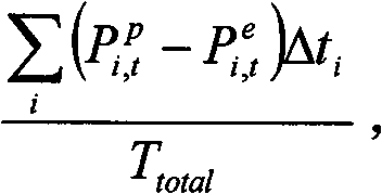
Then the unit interval error is:
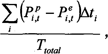 Δ t wherein
iBe the timeslice length between two track points, T
TatalBe flight time accumulation; The unit space error is:
Δ s wherein
iBe the spatial pieces length between two track points, S
TatalBe total distance of flying.These two indexs have reflected theoretical flight path and the experience flight path average integral gap on space-time and space respectively.As long as the both less than predetermined threshold, just can think that the reliability of theoretical model has reached acceptable level.
Δ t wherein
iBe the timeslice length between two track points, T
TatalBe flight time accumulation; The unit space error is:
Δ s wherein
iBe the spatial pieces length between two track points, S
TatalBe total distance of flying.These two indexs have reflected theoretical flight path and the experience flight path average integral gap on space-time and space respectively.As long as the both less than predetermined threshold, just can think that the reliability of theoretical model has reached acceptable level.
2) supplementary parameter
In the middle of theoretical model, owing to be subjected to the restriction of physical condition, possible some crucial model parameter can't be obtained, and this will directly cause model can't carry out prediction work.Therefore for the whole model of closure, must replenish initial parameter.And this is finished by empirical model usually.Here needing to replenish initialized important parameter comprises:
Takeoff speed:
 I=1 wherein, 2,3...n, j=1,2,3 ... m;
M is the section of the taking off track points number of definition, and n is the flight path number.
The control intention: the control intention mainly comprises horizontal control intention and two kinds of vertical control intentions.It has reflected guiding and the flight orders operation that the controller carries out aircraft.
The level intention mainly is the formed actual flight path Control Node of flight paragraph of standoff on cross track.Comprise that flight path deflects away from a little, flight path virtual navigation point sequence, flight path reentry point.
Vertical intention mainly is the rise and fall control command of carrying out on vertical section.Comprise and highly regulate starting point, highly regulate terminating point, escalating rate/rate of descent.
Average escalating rate: the weighted mean by the escalating rate of ascent stage is obtained.
Average rate of decrease: the weighted mean by the rate of descent of descending branch is obtained.
Weather data: wind speed on the way that historical analysis is obtained and the speed in the experience track are asked phasor difference, this difference is added adjustment factor add to speed term in the theoretical model, can regulate this coefficient according to meteorology at that time before taking off.
3) substitution effect
Generally, whole flight course is divided into the indicated airspeed sections of climbing such as quickening the section of climbing, low latitude, the flat section of flying for the Accurate Analysis flight path, the indicated airspeed sections of climbing such as high-altitude, the Mach number sections of climbing such as high-altitude, flat each the air route section that flies in air route, initial descending branch, middle descending branch, paragraphs such as last descending branch.
In fact first above-mentioned proof procedure should all be carried out in superincumbent each stage, if can't fit tightly with empirical model at certain paragraph through the theoretical model of revising, then can directly give theoretical model with relevant empirical parameter.Also promptly substitute theoretical model and finish high-precision forecast with empirical model.
4, radar data is to the correction of accurate 4D prediction locus
After taking off, secondary radar promptly may detect target and transmits definite positional information (longitude, latitude and height), temporal information, velocity information (size and Orientation), and upgrades with radar period.At this, real radar data can be fed back in the model and go, the 4D track is revised.
Consider that commercial airliner substantially all is highly flight of air route, plan according to the rules, the predicted value of position in the 4D track and height and practical flight value difference are apart from little thus, subject matter is exactly the forecasting problem of time dimension, so this paper only provides the modification method about predicted time.
Correction has three kinds of situations opportunity, as long as select wherein a kind of: a) press the radar period correction, promptly receive new data (position, time, highly, speed) just to the prediction locus correction afterwards of this position, at this moment the meticulousst modification method, the correction number of times is maximum; Arrive the correction of plan way point, be near certain reporting point when radar data shows target, the prediction locus correction after this point; The correction of deviation thresholding is set on arrival plan way point correction and the air route to be carried out simultaneously.
Correcting process process each time is basic identical, is that example deals with second kind of situation mainly at this.Target data Data (the x that the up-to-date radar data frame that receives is formed after too much Radar Data Fusion
r, y
r, t
r, h
r, v
r), utilize following formula to judge whether this target is near the plan way point of prediction locus, the way point scope is set for being 10 kilometers of center radius (variable element) with this point:
Wherein i when satisfying following formula, illustrates that target is at way point i place for planning any one in the way point.Obtain the mistiming Δ t in way point i predicted time and the target data
r=t
r-wp
i(t), as the reference data of revising.
Predicted time in the 4D prediction locus is revised, two kinds of methods are arranged: the one, directly the mistiming that will obtain above affacts this way point on the prediction way point time afterwards, and just whole time dimension has been made drift correction promptly:
Wp
M, i+1(t)=wp
I+1(t)+Δ t
rFormula (9);
I is all way points that target flight will be passed through in the formula.This method is simple and easy to calculate.But when the current flying speed of this point and predetermined speed difference were very big, predicated error was also big.
The 2nd, speed is considered in the correction model, with following formula the time is revised:
I is all way points that target flight will be passed through in the formula, the accuracy height of revising in this way when velocity perturbation is big.
In flight course, constantly prediction locus is revised according to the method described above, desired track accurately is provided, can make things convenient for the controller to understand following air traffic situation.
Core of the present invention is based on the basis of flight planning, aircraft performance parameter, historical flying quality, create the model that a kind of high precision 4D (four dimension) flight track is calculated, utilize real-time radar data that the flight planning flight path is predicted reckoning.
This method is mainly used in Air Traffic Control Automation System and flight flow management system, obtains accurate, continuous, level and smooth flight planning flight path prediction in real time.
The present invention is based on flight planning information, consider performance data, environmental data and the historical flying experience data of flight object, set up high-precision 4D flight model, and introduce real-time radar data on this basis and constantly proofread and correct, so that form desired track accurately, the objective of the invention is to improve the precision of flight planning prediction flight path, predicated error is controlled at bottom line.
The invention provides a kind of thinking and method of the method for analyzing high precision 4 D flight trajectory of airplane based on real-time radar data; the method and the approach of this technical scheme of specific implementation are a lot; the above only is a preferred implementation of the present invention; should be understood that; for those skilled in the art; under the prerequisite that does not break away from the principle of the invention, can also make some improvements and modifications, these improvements and modifications also should be considered as protection scope of the present invention.The all available prior art of each component part not clear and definite in the present embodiment is realized.
Claims (2)
1. the method for analyzing high precision 4 D flight trajectory of airplane based on real-time radar data is characterized in that, this method may further comprise the steps:
Step (1) is set up the 4D flight path theoretical model based on aeroplane performance;
Described foundation may further comprise the steps based on the 4D flight path theoretical model of aeroplane performance:
Step (a) is extracted flight planning information, spatial domain information and model-performance parameter: described flight planning information comprises flight number, type, E.T.D(estimated time of departure), the landing airport; Described spatial domain information comprises standard mission program, course line, air route, at advance the to leave the theatre course line and the restriction of various spatial domain on landing airport; Described model-performance parameter comprises the performance data of type correspondence, i.e. aircraft basis geometric parameter, aircraft basic motive mathematic(al) parameter, aircraft configuration information, engine parameter, speed envelope curve, fuel consume; Wherein aircraft basic motive mathematic(al) parameter comprises lift coefficient, resistance coefficient and the climb rate; Aircraft configuration information comprises the industry dead weight capacity and the center of gravity of aircraft;
Step (b) is set up the horizontal model of aircraft track:
Utilize flight planning information, spatial domain information in the step (a), advance departure procedure information, for each flight determine its flight the course line, air route, determine its approach course and the course line of leaving the theatre, thereby form the complete horizontal flight flight path of certain flight;
Step (c) is set up the aircraft track vertical mould:
Utilize step (a) in model-performance information set up the motion model of the climbing of aircraft, decline and air route flight, and be incorporated into departure procedure and carry out the flight path constraint, form the vertical flight flight path of certain complete flight;
Step (d) with aircraft the horizontal range s of process be basic parameter, in cross track model that step (b) and step (c) are set up and path in elevation model, find corresponding 2 points respectively, promptly in the cross track model, represent aircraft to be the some p1 of s from the beginning horizontal flight distance of taking off, and in the path in elevation model, represent aircraft to be the some p2 of s from the beginning horizontal flight distance of taking off, two spot correlations are joined, obtain latitude and longitude coordinates and the height of p2 and the flight time at that time of p1 respectively, form 4D volume coordinate point, thereby form 4D flight path theoretical model based on aeroplane performance;
The described horizontal model of aircraft track of setting up may further comprise the steps:
Step (a) definition cross track, from the plan information of landing airport, Standard Instrument Approach and/or leave the theatre course line and air route information, cruising altitude extract aircraft by way of way point and leap height, set up three-dimensional flight track framework, cross track promptly through the projection line of way point at surface level;
The air route and the course line of advancing to leave the theatre are made of a series of air routes landmark point, are WP with the sequence definition of putting
i, number is RPn, determines radius of turn r according to flying speed
i, definition constrained type type
i: initial point constraint, general point constraint and terminal constraint, simplified model is:
G
f={wp
1(x
1,y
1,type
1,r
1),…,wp
i(x
i,y
i,type
i,r
i),…,wp
RPn(x
RPn,y
RPn,type
RPn,r
RPn)};
Step (b) is handled turning point, if the initial point constraint is then flown nonstop to down a bit; Turn Models is considered in the general point constraint; The necessary line up with runway of head when end is constrained to aircraft through this; According to the above constraint, structure comprises radius of turn r, the Turn Models of turning point P, Q coordinate:
Radius of turn
G is an acceleration of gravity, and flying speed is v during turning, and the pitch angle is φ; The course angle of aircraft flight is with reference to zero degree with direct north, increases along clockwise direction, is 359 degree to the maximum; Use α
12The course angle of representing last leg, α
23The course angle of one leg, expression back according to 3 line relation, judges that aircraft is to turn left, turn right or fly nonstop to; In conjunction with the course angle of two sections flights with turn to, obtain aircraft turning angle Δ α; According to turning angle and radius of turn, obtain the distance of P point-to-point i: D
P, i=r * tan (Δ α/2), the coordinate that draws turning point P is:
The Q point coordinate is:
Final cross track mark is made up of a series of orderly points:
G
f={wp
1(x
1,y
1),…,P
i(x
i,y
i),Q
i(x
i,y
i),…,wp
RPn(x
RPn,y
RPn)};
The described aircraft track vertical mould of setting up may further comprise the steps:
Step (a) is divided the paragraph of flight path in elevation model, according to five stages of flight: take off, climb, flatly fly, descend, land, whole path in elevation computation model is divided into the calculating that five submodels are handled above-mentioned five paragraphs respectively;
Step (b) is determined flight path in elevation model basic parameter, described vertical mould be aircraft in height-time or height-range coordinate system motion model, definite effect external force aboard: motor power F, direction becomes engine installation angle lift L perpendicular to flying speed v along engine axis with fuselage axis X-shaped; Resistance D is parallel to flying speed; Gravity G is downward; α is the angle of attack, and θ is a flight-path angle; The method that adopts Newton second law and conservation of energy principle to combine is listed the submodel equation of each inflight phase correspondence, use imfinitesimal method and divided the segment of some five equilibriums each stage, the substitution aircraft is in the performance parameter of each stage correspondence, find the solution the rising/rate of descent of every segment, corresponding distance and time, adding up at last forms altitude profile and velocity profile, and obtains flight time accumulation;
Step (c) is determined the model of the sliding race process of takeoff phase:
The sliding race process of takeoff phase, sliding speed is parallel to surface level, the friction force f of tire and runway face;
Sliding the kinetics equation of race stage foundation along runway heading:

Wherein μ is the runway friction factor, and m is an aircraft weight, and g is an acceleration of gravity,
 Be percentage speed variation,
 Be the runway gradient, gravity component in the horizontal direction:

In the starting heats stage, aircraft angle of attack is assumed to the shutdown angle of attack, draws acceleration a, with given flying speed V
LOFThe substitution formula:

 Adopt numerical integrating to slide and sue for peace after the race section is divided into the independent integration of segment, draw ground roll-out distance and sliding race time;
Step (d) is determined aerial each inflight phase model:
In all stages after liftoff before land, use equation:

Wherein h is an aircraft place height, v
TASBe the flight true air speed; In the top formula
 Described C
DAnd C
LBe given resistance coefficient of aeroplane performance parameter and lift coefficient, ρ is an atmospheric density, and S is a wing area;
Described C
DAnd C
LBe given resistance coefficient of aeroplane performance parameter and lift coefficient, ρ is an atmospheric density, and S is a wing area;
According to the thrust magnitude of ramp-up period correspondence, obtain escalating rate, obtain the used time behind certain height that rises with numerical integration; Obtain percentage speed variation, binding time and percentage speed variation are obtained the horizontal range of every segment; Add the fuel consume coefficient, obtain the amount of fuel that per stage consumes, every segment weight is constant in approximate thinking, following a bit of weight is that the preceding paragraph weight deducts amount of fuel; Result's summation of every segment is obtained time, distance, the speed of ultimate demand;
Cruising phase adopts equal altitudes and waits the Mach number mode to carry out; Stipulated most economical cruise speed or Mach number in the described aeroplane performance parameter, used kinematical equation and obtain cruise time, distance, amount of fuel; Aircraft drops to specified altitude assignment with the maximum gliding angle of regulation, obtains voyage and time;
The performance parameter of substitution decline stage correspondence is obtained rate of descent, obtains the used time by integration; Obtain percentage speed variation, binding time is obtained distance, has formed the vertical mould of whole airflight;
Step (2) based on the historical flight path data of aircraft model in the step (1), is set up 4D flight path empirical model by mining analysis;
Described step (2) during to the comprehensive flight path output information of control automated system and implementing plan corresponding weather information carry out the admission of certain hour, these data are put in order as data source;
Specifically may further comprise the steps:
Step (a) generates the experience flight path:
The comprehensive output information of every frame of district's guard system output is a collection of aerial target status information and following desired track information at that time; By playing the historical comprehensive output information of a period of time, Frame is contrasted one by one, flight path by flight number, landing airport, actual time of departure, type and flight path information number all is encapsulated in this flight object set as the sign of unique object position sequence, height sequence, the time corresponding sequence with whole flight course, promptly forms the historical track of flight; To same flight object, in the repeatedly flight of a period of time, the object set that encapsulates has a plurality of, and a plurality of historical tracks are promptly arranged:
T(obj,i)={x
j,y
j,h
j,t
j,v
j}(i=(1,2,…,n),j=(1,2,…,m));
Wherein obj is the flight object, and n is the flight total degree, and equation the right is position, time, the velocity information of each tracing point, and m is the tracing point number of each flight path; To a plurality of track set of each flight object,, draw the experience track of this object with every data difference weighted; Processing procedure comprises parameter alignment and weighted;
Described parameter is aligned to a plurality of track set to same target, comprise and calculate the distance between first tracing point and original base in each set, starting point in the big set of selected distance is as the position reference point, point in other set before this position is rejected, and forms approximate unified origin information; The time of all starting points is located zero point, the time sequencing skew of back tracing point;
Described weighted is to single object, comprise with the position in a plurality of historical tracks set after the parameter alignment, time, speed respectively weighted draw the experience track of this object;
W wherein
i, u
i, r
i, s
i, z
iBe the weights coefficient, j is a tracing point, adds up to the effective number after parameter is alignd; Determine good plan air route according to plan information, with the subpoint of tracing point in the plan air route is benchmark, it is the scope interval at center that reference point is set, each weights coefficient gets 1 in one times of interval, each weights gets 0.5 between two times of intervals, weights are the inverse of interval multiple just in several times of intervals, and the coefficient outside 5 times of intervals gets 0.1, draws the experience track of this object;
Step (b) is handled the upper-level winds meteorology:
Described weather data analysis comprises: a GRIB message comprises the upper-level winds information in the territory, eighth of the earth, each height layer sends a message, according to the GRIB message format historical data is resolved, obtain temperature, wind direction and the wind speed of certain location point upper-level winds; According to the experience track of certain object, the weather information of each tracing point of coupling comprises on the way wind direction and wind speed in weather data; These data are kept in the community set of this object;
Step (3), the empirical model that theoretical model that step (1) is obtained and step (2) obtain combines, various influence factors in the flight course are quantized to become adjustable parameter, promptly obtain an accurate 4D flight path mixture model of considering the extraneous factor variation based on aeroplane performance again;
Accurate 4D flight path mixture model carries out verification and supplementary parameter to the described theoretical model of step (1) in the described step (3);
Described verification comprises time error and space error verification;
If theoretical flight path is
 Wherein n is the prediction track points number of theoretical flight path;
And the experience flight path is
 Wherein m is the prediction track points data of experience flight path;
Get m=n;
Wherein
 All be space-time four-dimentional space point, promptly contain { x, y, z, t} 4-coordinate;
Then the unit interval error is:
 Δ t wherein
iBe the timeslice length between two track points, T
TatalBe flight time accumulation; The unit space error is:
Δ t wherein
iBe the timeslice length between two track points, T
TatalBe flight time accumulation; The unit space error is:
 Δ s wherein
iBe the spatial pieces length between two track points, S
TatalBe total distance of flying;
Δ s wherein
iBe the spatial pieces length between two track points, S
TatalBe total distance of flying;
Described supplementary parameter comprises: takeoff speed
 I=1 wherein, 2,3...n, j=1,2,3 ... m; M is the section of the taking off track points number of definition, and n is the flight path number; Control intention, control intention comprise horizontal control intention and vertical control intention; Level is intended that the formed actual flight path Control Node of flight paragraph of standoff on cross track, comprises that flight path deflects away from a little, flight path virtual navigation point sequence, flight path reentry point; Vertically be intended that the rise and fall control command of on vertical section, carrying out, comprise and highly regulate starting point, highly regulate terminating point, escalating rate or rate of descent; Average escalating rate is obtained by the weighted mean of the escalating rate of ascent stage; Average rate of decrease: the weighted mean by the rate of descent of descending branch is obtained; Weather data, wind speed on the way that historical analysis is obtained and the speed in the experience track are asked phasor difference, this difference is added adjustment factor add to speed term in the theoretical model, and basis meteorology is at that time regulated this coefficient taking off before;
Step (4) with the described 4D flight path of radar data correction mixture model, forms final aircraft flight flight path.
2. the method for analyzing high precision 4 D flight trajectory of airplane based on real-time radar data according to claim 1, it is characterized in that, described step (4) comprises that secondary radar promptly may detect Aircraft Target and transmits definite positional information, temporal information, velocity information, and upgrade, and the time is revised with radar period; The described time is modified to by on radar period correction or arrival plan way point correction or arrival plan way point correction and the air route correction of deviation thresholding being set carries out simultaneously.
Priority Applications (1)
| Application Number | Priority Date | Filing Date | Title |
|---|---|---|---|
| CN2009100353252A CN101692315B (en) | 2009-09-25 | 2009-09-25 | Method for analyzing high precision 4D flight trajectory of airplane based on real-time radar data |
Applications Claiming Priority (1)
| Application Number | Priority Date | Filing Date | Title |
|---|---|---|---|
| CN2009100353252A CN101692315B (en) | 2009-09-25 | 2009-09-25 | Method for analyzing high precision 4D flight trajectory of airplane based on real-time radar data |
Publications (2)
| Publication Number | Publication Date |
|---|---|
| CN101692315A CN101692315A (en) | 2010-04-07 |
| CN101692315B true CN101692315B (en) | 2011-08-10 |
Family
ID=42080998
Family Applications (1)
| Application Number | Title | Priority Date | Filing Date |
|---|---|---|---|
| CN2009100353252A Active CN101692315B (en) | 2009-09-25 | 2009-09-25 | Method for analyzing high precision 4D flight trajectory of airplane based on real-time radar data |
Country Status (1)
| Country | Link |
|---|---|
| CN (1) | CN101692315B (en) |
Cited By (2)
| Publication number | Priority date | Publication date | Assignee | Title |
|---|---|---|---|---|
| US9177479B2 (en) | 2013-03-13 | 2015-11-03 | General Electric Company | System and method for determining aircraft operational parameters and enhancing aircraft operation |
| US11447018B2 (en) * | 2017-04-18 | 2022-09-20 | Skytran, Inc. | Path correction of a vehicle relative to projected magnetic flight path |
Families Citing this family (92)
| Publication number | Priority date | Publication date | Assignee | Title |
|---|---|---|---|---|
| CN102013175B (en) * | 2010-12-16 | 2012-07-04 | 四川川大智胜软件股份有限公司 | Mid-term air traffic conflict detection method based on 4D flight path and radar data |
| ITRM20110651A1 (en) * | 2010-12-20 | 2012-06-21 | Selex Sistemi Integrati Spa | METHOD OF QUICK PREDICTION OF THE VERTICAL PROFILE OF THE TRAJECTORY FOR THE MANAGEMENT OF AIR TRAFFIC, AND ITS RELATED ATM SYSTEM. |
| US20120215434A1 (en) * | 2011-02-22 | 2012-08-23 | General Electric Company | Methods and systems for managing air traffic |
| FR2973526B1 (en) * | 2011-03-29 | 2013-04-26 | Airbus Operations Sas | METHOD AND DEVICE FOR AUTOMATICALLY MANAGING THE VERTICAL PROFILE OF A FLIGHT PLAN OF AN AIRCRAFT |
| CN102509475B (en) * | 2011-10-26 | 2013-11-06 | 南京航空航天大学 | Air traffic control system and method for four-dimensional (4D)-trajectory-based operation |
| US8798898B2 (en) * | 2011-10-31 | 2014-08-05 | General Electric Company | Methods and systems for inferring aircraft parameters |
| CN102496313B (en) * | 2011-12-31 | 2013-10-23 | 南京莱斯信息技术股份有限公司 | Correction method of aircraft plan prediction locus by using supervision data |
| US9567097B2 (en) * | 2012-02-03 | 2017-02-14 | Rosemount Aerospace Inc. | System and method for real-time aircraft performance monitoring |
| FR2990527B1 (en) * | 2012-05-09 | 2014-05-23 | Airbus Operations Sas | METHOD AND DEVICE FOR AIDING THE FLIGHT MANAGEMENT OF AN AIRCRAFT DURING A LANDING PHASE. |
| US20140067267A1 (en) * | 2012-08-31 | 2014-03-06 | Ge Aviation Systems Llc | Methods for determining suitable waypoint locations |
| CN103135556B (en) * | 2013-01-25 | 2015-01-28 | 北京航空航天大学 | Flight method for improving application performance of solar power unmanned aerial vehicle |
| CN103207937B (en) * | 2013-04-15 | 2016-01-13 | 大连海事大学 | A quaternary ship safety domain model system and ship collision avoidance method |
| CN103678925B (en) * | 2013-12-10 | 2016-10-05 | 西北工业大学 | Flight path classification method based on auxiliary information source |
| EP2927771B1 (en) * | 2014-04-03 | 2024-01-31 | Dronisos | Flying drone trajectory synchronization |
| US20150348423A1 (en) * | 2014-05-27 | 2015-12-03 | Honeywell International Inc. | System and method for economizing flight expenditures during aircraft descent and approach |
| CN104240541B (en) * | 2014-09-09 | 2016-01-27 | 中国电子科技集团公司第二十八研究所 | A 4D Track Generation Method |
| CN105701552B (en) * | 2014-10-11 | 2021-09-03 | 中国国际航空股份有限公司 | Method for determining vertical section of flight route |
| CN104457735A (en) * | 2014-10-27 | 2015-03-25 | 中国民航大学 | 4D trajectory displaying method based on World Wind |
| CN104503824B (en) * | 2014-12-24 | 2017-07-18 | 南京航空航天大学 | A kind of airmanship towards Civil Aviation ATM analyzes checking system |
| CN104569944B (en) * | 2014-12-26 | 2017-08-01 | 中国民用航空华东地区空中交通管理局安徽分局 | Radar flight check interpretation of result system |
| CN106169260A (en) * | 2015-01-07 | 2016-11-30 | 江苏理工学院 | Air traffic control method |
| CN106571068A (en) * | 2015-01-07 | 2017-04-19 | 江苏理工学院 | Method for predicting track of aircraft based on 4D track operation |
| FR3032271B1 (en) * | 2015-01-30 | 2017-01-13 | Thales Sa | METHOD FOR IMPROVING A FLIGHT TRACK OF AN AIRCRAFT BASED ON WEATHER CONDITIONS |
| CN104713545A (en) * | 2015-02-12 | 2015-06-17 | 中国科学院长春光学精密机械与物理研究所 | Theoretical trajectory guidance pattern-based single-pole compensation method |
| CN104794213B (en) * | 2015-04-27 | 2018-02-02 | 清华大学 | Trajectory Prediction method based on flight plan and navigational route database |
| CN104792328A (en) * | 2015-04-28 | 2015-07-22 | 中国航空工业集团公司沈阳飞机设计研究所 | Method for designing air route based on GIS map |
| FR3037158B1 (en) * | 2015-06-05 | 2018-06-01 | Thales | TRACK MONITORING |
| CN105278536B (en) * | 2015-11-05 | 2018-05-25 | 北京航天科颐技术有限公司 | A kind of UAV Attitude keeps system |
| CN105355092B (en) * | 2015-12-03 | 2017-12-22 | 上海民航华东空管工程技术有限公司 | A kind of flight flow pre-control method |
| FR3046228B1 (en) * | 2015-12-29 | 2018-01-05 | Thales | METHOD FOR THREE-DIMENSIONALLY GRAPHIC REPRESENTATION OF A LANDING TRACK ON AN AIRCRAFT VISUALIZATION DEVICE |
| CN105427676B (en) * | 2015-12-30 | 2017-12-08 | 北京招通致晟科技有限公司 | Method and device for determining time for aircraft to pass through departure point |
| CN105427675B (en) * | 2015-12-30 | 2018-05-01 | 北京招通致晟科技有限公司 | Prediction method and device for landing time of aircraft |
| CN105608509A (en) * | 2015-12-30 | 2016-05-25 | 北京招通致晟科技有限公司 | Horizontal projection trajectory prediction method and device for 4D flight path of aircraft |
| CN105759630B (en) * | 2016-03-03 | 2018-06-26 | 中国民航大学 | Aircraft 4D track Simulations system and emulation mode based on fuzzy-adaptation PID control |
| CN105894117B (en) * | 2016-03-31 | 2020-02-18 | 北京航空航天大学 | Track prediction method and device |
| US9984578B2 (en) * | 2016-05-03 | 2018-05-29 | Rockwell Collins, Inc. | Digital map enabled boundary search pattern |
| CN105894862B (en) * | 2016-05-05 | 2018-05-04 | 中国民用航空华东地区空中交通管理局 | A kind of air traffic control intelligence command system |
| CN106019987A (en) * | 2016-07-19 | 2016-10-12 | 四川九洲空管科技有限责任公司 | 3D interactive simulated flight path generation method and 3D interactive simulated flight path generation system |
| CN106205219B (en) * | 2016-08-31 | 2019-03-05 | 北京招通致晟科技有限公司 | Aircraft monitoring method and device based on fusion of multiple radar information |
| CN106776818A (en) * | 2016-11-25 | 2017-05-31 | 成都四威电子有限公司成都星石科技分公司 | A kind of GPS track modification method and system based on fishing boat personal feature storehouse |
| CN106768123A (en) * | 2016-11-30 | 2017-05-31 | 中国直升机设计研究所 | A kind of depopulated helicopter fuel oil predictor method |
| CN106648673B (en) * | 2016-12-28 | 2020-02-14 | 南京航空航天大学 | Analysis and design method of continuous descending operation program |
| US10228692B2 (en) * | 2017-03-27 | 2019-03-12 | Gulfstream Aerospace Corporation | Aircraft flight envelope protection and recovery autopilot |
| CN106950988A (en) * | 2017-04-18 | 2017-07-14 | 深圳城际快机科技有限公司 | UAV flight control method and flight control system |
| CN107424441B (en) * | 2017-06-08 | 2020-05-01 | 中国民航大学 | Detection and estimation method of aircraft track change point based on Hotelling's T2 statistic |
| CN107085978B (en) * | 2017-06-21 | 2020-02-18 | 南京航空航天大学 | A method for generating control-aided decision-making instructions based on required arrival time |
| CN107341620B (en) * | 2017-07-26 | 2021-04-23 | 南京航空航天大学 | Cost calculation method of arrival flight delay under short-term weather based on BADA fuel consumption rate |
| CN109389016B (en) * | 2017-08-10 | 2023-04-07 | 株式会社日立制作所 | Method and system for counting human heads |
| CN107622699B (en) * | 2017-09-26 | 2019-07-09 | 中国电子科技集团公司第二十八研究所 | Time-series-based full-time airspace conflict detection and resolution method |
| US11562006B2 (en) * | 2017-10-03 | 2023-01-24 | Ohio State Innovation Foundation | Apparatus and method for interactive analysis of aviation data |
| CN107966719B (en) * | 2017-12-22 | 2021-11-19 | 中国交通通信信息中心 | Single satellite positioning enhancement system and method based on signal decoding and probability screening |
| CN108257421A (en) * | 2017-12-22 | 2018-07-06 | 广州市中南民航空管通信网络科技有限公司 | A kind of flight Trajectory Prediction method, electronic equipment and storage medium |
| CN108507576B (en) * | 2018-03-27 | 2020-06-30 | 中国自然资源航空物探遥感中心 | Three-dimensional flight path planning method for aerial gravity measurement in middle and high mountainous areas |
| CN108957438B (en) * | 2018-06-23 | 2022-08-26 | 西安电子科技大学 | Random distance-based lag track association fusion method and system and application |
| CN108896973B (en) * | 2018-07-13 | 2022-05-31 | 北京无线电测量研究所 | Radar data calibration method, trace point quality evaluation method and storage medium |
| CN108877298B (en) * | 2018-07-25 | 2021-03-30 | 哈尔滨工业大学 | Flight plan safety judgment and early warning method based on four-dimensional track operation |
| CN108922252B (en) * | 2018-08-08 | 2020-08-25 | 四川航空股份有限公司 | Flight safety monitoring method and device |
| CN109191925B (en) * | 2018-10-17 | 2020-07-14 | 中国电子科技集团公司第二十八研究所 | A multi-airspace trajectory planning and negotiation method for four-dimensional trajectory operation |
| CN109493644B (en) * | 2018-11-16 | 2020-08-14 | 四川大学 | A four-dimensional track estimation method based on historical track data mining |
| CN109542876B (en) * | 2018-11-20 | 2023-04-07 | 南京莱斯信息技术股份有限公司 | Extraction method for mining aircraft empirical trajectory model key factors based on Hadoop data |
| CN109799842B (en) * | 2019-01-28 | 2020-07-31 | 南京航空航天大学 | Multi-unmanned aerial vehicle sequence flight control method |
| CN111897896A (en) * | 2019-05-06 | 2020-11-06 | 上海博泰悦臻网络技术服务有限公司 | Retrieval and presentation method, system, medium, server and client of aircraft type |
| CN110471055B (en) * | 2019-07-08 | 2021-03-30 | 岭澳核电有限公司 | Method and device for predicting flight path, readable storage medium and terminal equipment |
| CN110930770B (en) * | 2019-11-06 | 2022-01-25 | 南京莱斯信息技术股份有限公司 | Four-dimensional track prediction method based on control intention and airplane performance model |
| CN110969900B (en) * | 2019-11-21 | 2022-03-15 | 中国航空工业集团公司西安飞行自动控制研究所 | All-lane horizontal offset calculation method based on lane management |
| CN111047914B (en) * | 2019-11-28 | 2020-11-03 | 中国商用飞机有限责任公司北京民用飞机技术研究中心 | FMS track prediction method based on four-dimensional track operation |
| CN111210670B (en) * | 2020-01-21 | 2021-06-29 | 成都民航空管科技发展有限公司 | Method and system for centralized allocation of secondary radar transponder codes |
| CN111208482B (en) * | 2020-02-28 | 2022-02-18 | 成都汇蓉国科微系统技术有限公司 | Radar precision analysis method based on distance alignment |
| CN111292563B (en) * | 2020-05-12 | 2020-08-11 | 北京航空航天大学 | A Flight Track Prediction Method |
| CN111986522B (en) * | 2020-07-29 | 2022-03-22 | 广州市新航科技有限公司 | Airborne equipment positioning method based on ADS-B signal, airborne equipment and storage medium thereof |
| CN111846288B (en) * | 2020-07-30 | 2021-09-24 | 北京理工大学 | Differential game control method for soft landing of small celestial bodies in uncertain environment |
| CN111915934B (en) * | 2020-08-11 | 2021-10-08 | 民航数据通信有限责任公司 | A Track Continuity Analysis Method |
| CN112419792B (en) * | 2020-11-09 | 2021-11-30 | 中国科学院空天信息创新研究院 | Aircraft flight conflict detection method, system, device and medium |
| US11698452B2 (en) * | 2020-12-10 | 2023-07-11 | GM Global Technology Operations LLC | Target tracking during acceleration events |
| CN112506226B (en) * | 2020-12-24 | 2022-02-01 | 中国人民解放军军事科学院国防科技创新研究院 | Long-endurance unmanned aerial vehicle flight path planning method based on temperature constraint conditions |
| CN112927562B (en) * | 2021-01-28 | 2022-03-04 | 中国电子科技集团公司第二十八研究所 | A calculation method of aircraft flight altitude profile based on specified altitude limit |
| CN112818599B (en) * | 2021-01-29 | 2022-06-14 | 四川大学 | An Air Control Method Based on Reinforcement Learning and 4D Trajectory |
| CN113885574B (en) * | 2021-10-28 | 2023-07-25 | 中国人民解放军96901部队24分队 | A Cooperative Formation Control System for Multiple Unmanned Aerial Vehicles |
| CN114063653B (en) * | 2021-12-03 | 2023-12-29 | 中国人民解放军63892部队 | Space and time consistency constraint unmanned aerial vehicle high-precision track control method |
| CN114296068B (en) * | 2021-12-27 | 2025-04-22 | 成都福瑞空天科技有限公司 | A method for air-to-air radar data simulation based on deep learning |
| CN114721431B (en) * | 2022-04-06 | 2025-06-13 | 中国商用飞机有限责任公司 | Simulation method for predicting circling approach flight trajectory |
| CN115206135B (en) * | 2022-06-16 | 2024-02-13 | 中国电子科技集团公司第二十八研究所 | An aircraft command altitude planning method with uncertain climb rate |
| CN115292557B (en) * | 2022-07-29 | 2023-08-25 | 深圳微品致远信息科技有限公司 | Calculation method and device for running and taking off, computer equipment and storage medium |
| CN115081759B (en) * | 2022-08-22 | 2022-11-15 | 珠海翔翼航空技术有限公司 | Fuel-saving decision-making method, system and equipment based on historical flight data |
| CN115204526B (en) * | 2022-09-14 | 2022-12-20 | 中国民航信息网络股份有限公司 | Method, device and computer-readable medium for collecting and processing flight fuel data |
| CN115268504B (en) * | 2022-09-29 | 2022-12-27 | 四川腾盾科技有限公司 | Ground-imitating flight path planning method for large unmanned aerial vehicle |
| CN116148862B (en) * | 2023-01-16 | 2024-04-02 | 无锡市雷华科技有限公司 | Comprehensive early warning and evaluating method for bird detection radar flying birds |
| CN116796238B (en) * | 2023-07-13 | 2024-12-13 | 南京航空航天大学 | A short-term track deviation detection method for UAV based on four-dimensional track prediction |
| CN117198042B (en) * | 2023-08-25 | 2024-12-06 | 三峡智控科技有限公司 | A method, device, equipment and storage medium for predicting flight path |
| CN117422208B (en) * | 2023-12-18 | 2024-03-22 | 南京莱斯信息技术股份有限公司 | Method for distributing suggested time when no available time slot is available at domestic airport in cross-border flight coordination |
| CN118824066A (en) * | 2024-08-22 | 2024-10-22 | 培风智行(天津)科技有限责任公司 | An aircraft separation management method for low-altitude economy |
| CN120144639B (en) * | 2025-03-03 | 2025-09-16 | 中国人民解放军92728部队 | A multidimensional data mining and analysis system based on flight simulation |
Citations (2)
| Publication number | Priority date | Publication date | Assignee | Title |
|---|---|---|---|---|
| CN101046387A (en) * | 2006-08-07 | 2007-10-03 | 南京航空航天大学 | Scene matching method for raising navigation precision and simulating combined navigation system |
| CN101201978A (en) * | 2007-12-20 | 2008-06-18 | 四川川大智胜软件股份有限公司 | Short-term Air Traffic Flow Prediction Method Based on Real-time Radar and Flight Information |
-
2009
- 2009-09-25 CN CN2009100353252A patent/CN101692315B/en active Active
Patent Citations (2)
| Publication number | Priority date | Publication date | Assignee | Title |
|---|---|---|---|---|
| CN101046387A (en) * | 2006-08-07 | 2007-10-03 | 南京航空航天大学 | Scene matching method for raising navigation precision and simulating combined navigation system |
| CN101201978A (en) * | 2007-12-20 | 2008-06-18 | 四川川大智胜软件股份有限公司 | Short-term Air Traffic Flow Prediction Method Based on Real-time Radar and Flight Information |
Non-Patent Citations (1)
| Title |
|---|
| 李欣,彭世蕤.一种空间三维航迹建模新方法.《雷达科学与技术》.2007,(第5期),全文. * |
Cited By (2)
| Publication number | Priority date | Publication date | Assignee | Title |
|---|---|---|---|---|
| US9177479B2 (en) | 2013-03-13 | 2015-11-03 | General Electric Company | System and method for determining aircraft operational parameters and enhancing aircraft operation |
| US11447018B2 (en) * | 2017-04-18 | 2022-09-20 | Skytran, Inc. | Path correction of a vehicle relative to projected magnetic flight path |
Also Published As
| Publication number | Publication date |
|---|---|
| CN101692315A (en) | 2010-04-07 |
Similar Documents
| Publication | Publication Date | Title |
|---|---|---|
| CN101692315B (en) | Method for analyzing high precision 4D flight trajectory of airplane based on real-time radar data | |
| Zhang et al. | Online four dimensional trajectory prediction method based on aircraft intent updating | |
| CN109493644B (en) | A four-dimensional track estimation method based on historical track data mining | |
| CN102610126B (en) | The rapid vertical trajectory predictions method of air traffic control and relevant ATM system | |
| CN109801512B (en) | System considering breeze conditions in area and method for planning flight plan | |
| Chaloulos et al. | Effect of wind correlation on aircraft conflict probability | |
| US8645009B2 (en) | Method for flying an aircraft along a flight path | |
| Patron et al. | New altitude optimisation algorithm for the flight management system CMA-9000 improvement on the A310 and L-1011 aircraft | |
| Lymperopoulos et al. | Model based aircraft trajectory prediction during takeoff | |
| WO2011117242A1 (en) | Method of trajectory prediction | |
| US20250182631A1 (en) | System and method for optimising flight efficiency | |
| Tang et al. | 4D trajectory estimation based on nominal flight profile extraction and airway meteorological forecast revision | |
| CN112669651B (en) | Method for correcting and predicting over-point time based on EET value in flight dynamic information | |
| Porretta et al. | Performance evaluation of a novel 4D trajectory prediction model for civil aircraft | |
| EP2743739B1 (en) | Using aircraft trajectory data to infer atmospheric conditions | |
| Murrieta-Mendoza et al. | Performance DataBase creation using a level D simulator for Cessna Citation X aircraft in cruise regime | |
| CN113205706A (en) | ILS signal quality monitoring method based on flight QAR data | |
| Guan et al. | A study of 4D trajectory prediction based on machine deep learning | |
| Holzäpfel et al. | Aircraft wake vortex scenarios simulation package–WakeScene | |
| Lee et al. | Performance of trajectory models with wind uncertainty | |
| Thipphavong | Reducing aircraft climb trajectory prediction errors with top-of-climb data | |
| Stell | Analysis of flight management system predictions of idle-thrust descents | |
| Ren et al. | Workstation based fast-time aircraft simulator for noise abatement approach procedure study | |
| Elston et al. | Evaluation of unmanned aircraft systems for severe storm sampling using hardware-in-the-loop simulations | |
| Liu et al. | Research on Trajectory Generation and Optimization in Continuous Descent Operations |
Legal Events
| Date | Code | Title | Description |
|---|---|---|---|
| C06 | Publication | ||
| PB01 | Publication | ||
| C10 | Entry into substantive examination | ||
| SE01 | Entry into force of request for substantive examination | ||
| C14 | Grant of patent or utility model | ||
| GR01 | Patent grant |