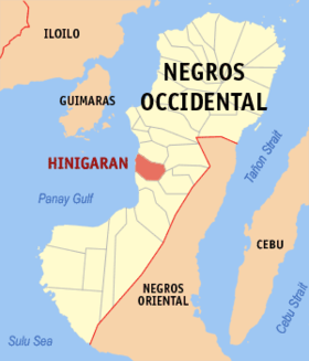
Hinigaran
Appearance
| Hinigaran | |
|---|---|
| Baley na Filipinas | |
 Lokasyon na Hinigaran | |
 | |
| 10°16′12″N 122°51′0″E | |
| Dalin | Filipinas |
| Angipaletnegan | 1768 |
| Barangay | 24 |
| Kaawang | |
| • Katiponan | 154.92 km2 (59.81 sq mi) |
| Elebasyon | 5 m (16 ft) |
| Bilang na too (Mayo 1, 2020)[1] | |
| • Katiponan | 88,909 |
| • Densidad | 570/km2 (1,500/sq mi) |
| Economia | |
| • Clase | unaan ya klase ya baley |
| • Ingresos | ₱325,044,719.63135,976,780.88 (2020) |
| • Activos | ₱738,126,601.73274,027,670.17 (2020) |
| • Pasivos | ₱305,283,035.23149,858,029.99 (2020) |
| • Gastos | ₱241,637,302.28 (2020) |
| Kodigo na postal | 6106 |
| Kodigo na lugar | 34 |
| Website |
www |
Say Hinigaran et unaan ya klase ya baley ed luyag na Negros ed Sagor, Filipinas. Unong ed 1 Mayo 2020 census, say populasyon to et 88,909 totoo tan 22,592 abong. Walay kabaleg tan sukat to ya 154.92 sq. km. Say zip code to et 6106.
Saray barangay
[dumaen | dumaen so pinanlapuan]- Anahaw
- Aranda
- Baranggay I (Pob.)
- Baranggay II (Pob.)
- Baranggay III (Pob.)
- Baranggay IV (Pob.)
- Bato
- Calapi
- Camalobalo
- Camba-og
- Cambugsa
- Candumarao
- Gargato
- Himaya
- Miranda
- Nanunga
- Narauis
- Palayog
- Paticui
- Pilar
- Quiwi
- Tagda
- Tuguis
- Baga-as
Demograpiko
[dumaen | dumaen so pinanlapuan]| Taon | Pop. | ±% p.a. |
|---|---|---|
| 1903 | 14,256 | — |
| 1918 | 16,097 | +0.81% |
| 1939 | 27,438 | +2.57% |
| 1948 | 29,017 | +0.62% |
| 1960 | 36,240 | +1.87% |
| 1970 | 46,010 | +2.41% |
| 1975 | 52,018 | +2.49% |
| 1980 | 54,717 | +1.02% |
| 1990 | 68,739 | +2.31% |
| 1995 | 71,519 | +0.75% |
| 2000 | 74,997 | +1.02% |
| 2007 | 80,528 | +0.99% |
| 2010 | 81,925 | +0.63% |
| 2015 | 85,602 | +0.84% |
| 2020 | 88,909 | +0.75% |
| Reperensiya: Philippine Statistics Authority[2][3][4] | ||
Saray reperensiya
[dumaen | dumaen so pinanlapuan]- ↑ "2020 Census of Population and Housing (2020 CPH) Population Counts Declared Official by the President". Hulyo 7, 2021. https://psa.gov.ph/content/2020-census-population-and-housing-2020-cph-population-counts-declared-official-president.
- ↑ Census of Population (2015). "Region VI (Western Visayas)". Total Population by Province, City, Municipality and Barangay. PSA. Retrieved 29 June 2016.
- ↑ Census of Population and Housing (2010). "Region VI (Western Visayas)". Total Population by Province, City, Municipality and Barangay. NSO. Retrieved 29 June 2016.
- ↑ Censuses of Population (1903–2007). "Region VI (Western Visayas)". Table 1. Population Enumerated in Various Censuses by Province/Highly Urbanized City: 1903 to 2007. NSO.