


Tool for converting 3D geometries from PostGIS to 3D Tiles. The generated 3D Tiles can be visualized in Cesium JS, Cesium for Unreal, Cesium for Unity3D, Cesium for Omniverse, Mapbox GL JS v3 beta (experimental) or other 3D Tiles client viewers.
Features:
-
3D Tiles 1.1 Implicit tiling;
-
3D Tiles extensions EXT_Mesh_Features and EXT_Structural_Metadata;
-
Valid glTF 2.0 files;
-
Shading PbrMetallicRoughness and PbrSpecularGlossiness;
-
Query parameter support;
-
Cesium: LOD support and Outlines support (using CESIUM_primitive_outline);
-
Triangulation of input geometries MultiPolygon/PolyhedralSurface;
-
Docker support.
Resulting tilesets are validated against 3D Tiles Validator (https://github.com/CesiumGS/3d-tiles-validator).
To run this tool there must be a PostGIS table available containing polyhedralsurface/multipolygon geometries.
Tileset.json and b3dm tiles are by default created in the 'output/content' subdirectory (or specify output directory with -o, --output).
Convert 3D Data (Multipolygon Z) to 3D Tiles
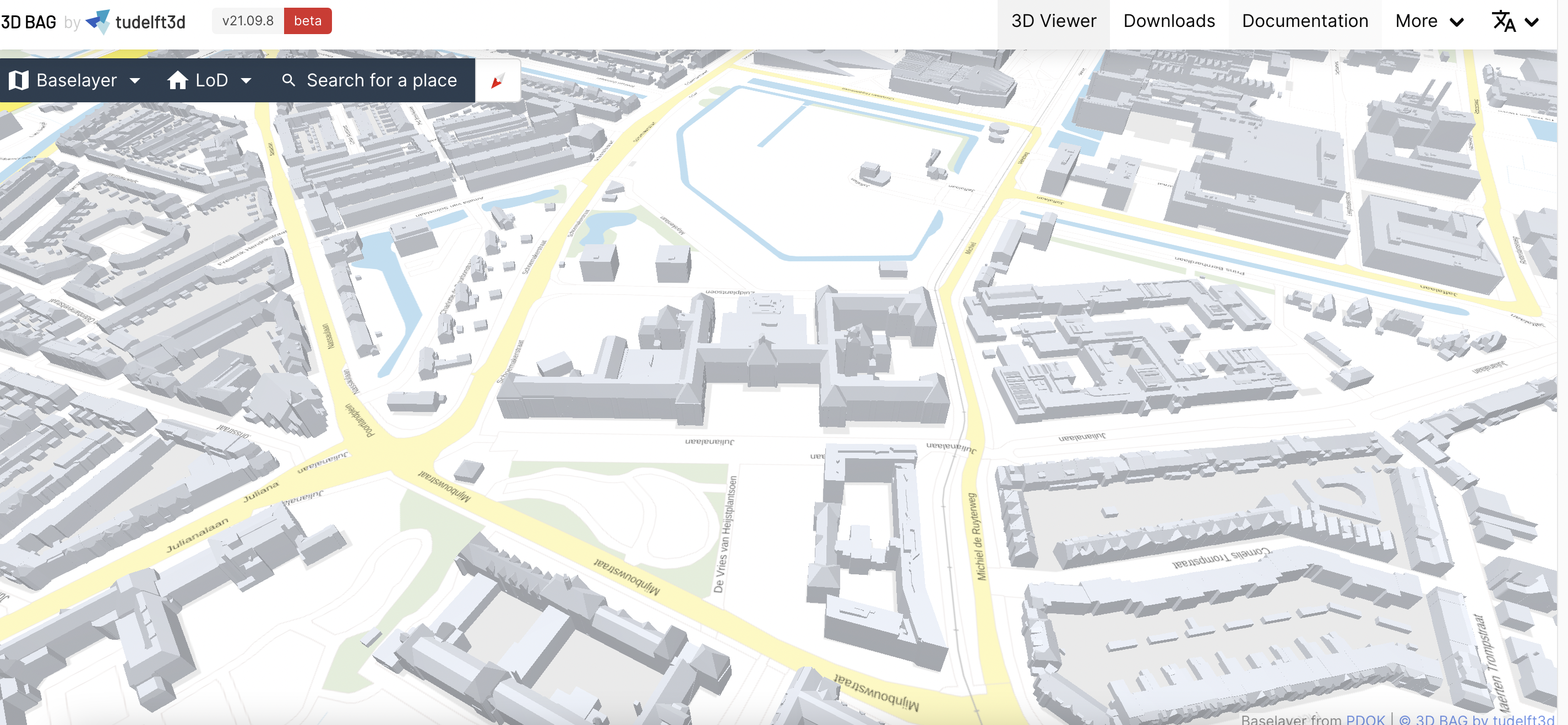
- Download Geopackage from https://3dbag.nl/, for example https://3dbag.nl/nl/download?tid=7-480-624
Result: 7-480-624.gpkg (18 MB)
- Import in PostGIS database, convert to Cesium coordinates
$ ogr2ogr -f PostgreSQL pg:"host=localhost user=postgres password=postgres" -t_srs epsg:4978 7-480-624.gpkg lod22_3d
- Convert to 3D Tiles using pg2b3dm
$ pg2b3dm -h localhost -U postgres -c geom -d postgres -t lod22_3d -a identificatie
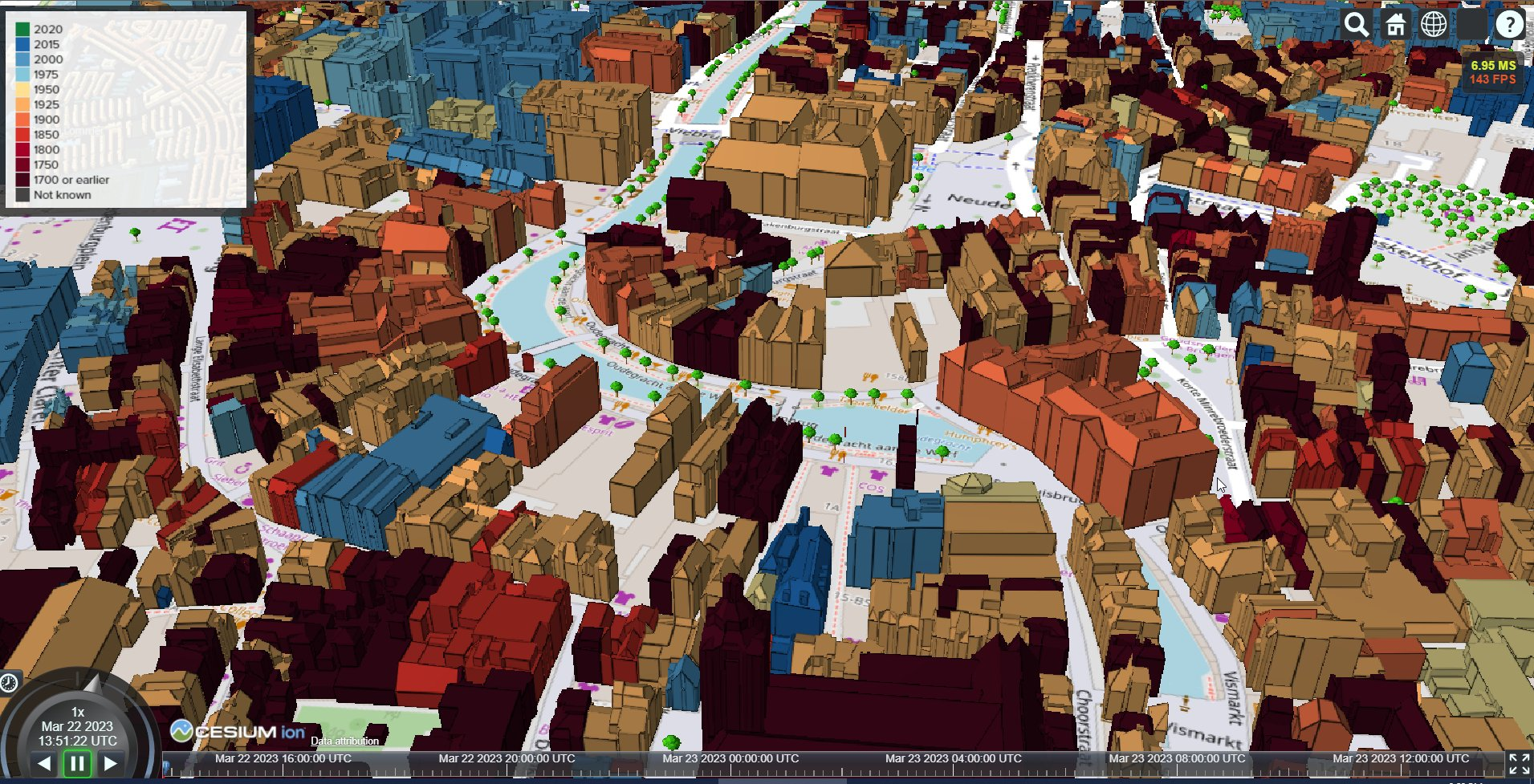
- Load 3D Tiles in Cesium viewer, example result see https://geodan.github.io/pg2b3dm/sample_data/3dbag/tienhoven/
Older getting started documents:
1] See getting started for a tutorial how to convert a 2D shapefile of buildings with height attribute to 3D Tiles and visualize in CesiumJS/Cesium for Unreal/Unity3D.
2] For a dataprocessing workflow from CityGML to 3D Tiles using GDAL, PostGIS and FME see dataprocessing/dataprocessing_citygml.

- 3D Bag by tudelftnl - 10 million Dutch buildings in 3D Tiles https://3dbag.nl/
- FOSS4G presentations
Presentation at FOSS4G 2021: A fast web 3D viewer for 11 million buildings https://www.youtube.com/watch?v=1_JM2Xf5mDk
Presentation at FOSS4G 2019: 3D geodata in the MapBox GL JS viewer with 3D Tiles https://www.youtube.com/watch?v=HXQJbyEnC9w
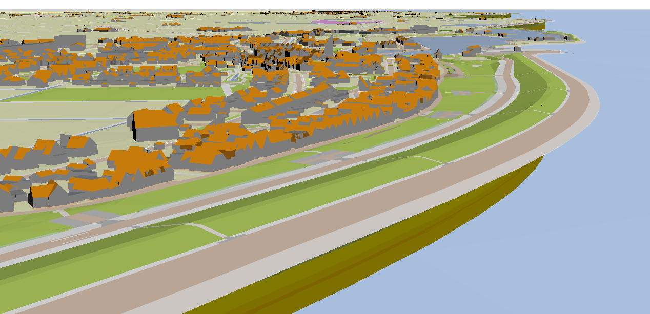
- Texel - 3D Terrain, subsurface and buildings in MapBox GL JS: http://beta.geodan.nl/mapbox3d
-
GeoTop Subsurface in MapBox GL JS: https://geodan.github.io/pg2b3dm/sample_data/geotop/mapbox/
-
Amsterdam Buildings in MapBox GL JS: https://geodan.github.io/pg2b3dm/sample_data/amsterdam/mapbox/
-
Amsterdam Buildings in Cesium: https://geodan.github.io/pg2b3dm/sample_data/amsterdam/cesium/
-
Dover - Delaware buildings in MapBox GL JS: https://geodan.github.io/pg2b3dm/sample_data/delaware/mapbox/
-
Dover - Delaware buildings in Cesium: https://geodan.github.io/pg2b3dm/sample_data/delaware/cesium/
-
Duisburg buidings converted from CityGML in MapBox GL JS - https://geodan.github.io/pg2b3dm/sample_data/duisburg/mapbox/#15.62/51.430166/6.782675/0/45
All parameters are optional, except the -t --table option.
If --username and/or --dbname are not specified the current username is used as default.
  -U, --username                  Database user

  -h, --host                      (Default: localhost) Database host

  -d, --dbname                    Database name

  -c, --column                    (Default: geom) Geometry column

  -t, --table                     Required. Database table, include database schema if needed

  -p, --port                      (Default: 5432) Database port

  -o, --output                    (Default: output) Output path

  -a, --attributecolumns          (Default: '') Attribute columns

  -q, --query                     (Default: '') Query parameter

  --copyright                     (Default: '') glTF asset copyright

  --default_color                 (Default: #FFFFFF) Default color

  --default_metallic_roughness    (Default: #008000) Default metallic roughness

  --double_sided                  (Default: true) Default double sided

  --create_gltf                   (Default: true) Create glTF files

  --max_features_per_tile         (Default: 1000) maximum features per tile (Cesium)

  -l, --lodcolumn                 (Default: '') LOD column (Cesium)

  -g, --geometricerrors           (Default: 2000,0) Geometric errors (Cesium)

  --shaderscolumn                 (Default: '') shaders column (Cesium)

  --use_implicit_tiling           (Default: true) use 1.1 implicit tiling (Cesium)

  --boundingvolume_heights        (Default: 0,100) Tile boundingVolume heights (min, max) in meters (Cesium)

  --add_outlines                  (Default: false) Add outlines (Cesium)

  -r, --refinement                (Default: REPLACE) Refinement ADD/REPLACE (Cesium)

  --min_zoom                      (Default: 15) Minimum zoom level (Mapbox)

  --max_zoom                      (Default: 15) Maximum zoom level (Mapbox)

  --help                          Display this help screen.

  --version                       Display version information.
Sample command for running pg2b3dm:
-h localhost -U postgres -c geom_triangle --shaderscolumn shaders -t delaware_buildings -d postgres -g 100,0
Prerequisite: .NET 6.0 SDK is installed https://dotnet.microsoft.com/download/dotnet/6.0
$ dotnet tool install -g pg2b3dm
Or update
$ dotnet tool update -g pg2b3dm
To run:
$ pg2b3dm
For styling see styling 3D Tiles
Input geometries must be of type PolyhedralSurface or Multipolygon (with z values). When the geometry is not triangulated, pg2b3dm will perform triangulation.
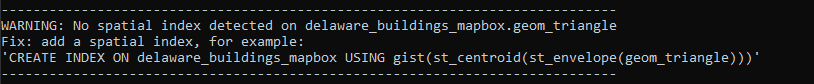
For large datasets create a spatial index on the geometry column:
psql> CREATE INDEX ON the_table USING gist(st_centroid(st_envelope(geom_triangle)));
When there the spatial index is not present the following warning is shown.
The -q --query will be added to the 'where' part of all queries.
Samples:
Attribute query:
-q "ogc_fid=118768"
Spatial query:
-q "ST_Intersects(wkb_geometry, 'SRID=4326;POLYGON((-75.56996406 39.207228824,-75.56996406 39.2074420320001,-75.5696300339999 39.2074420320001,-75.5696300339999 39.207228824,-75.56996406 39.207228824))'::geometry)"
Make sure to check the indexes when using large tables.
With the -a attributecolumns parameter multiple columns with attributes can be specified. The attribute information is stored in the b3dm batch table. Multiple columns must be comma separated:
Sample: --attributescolumns col1,col2
Attribute columns can be of any type.
For Cesium support (tiling schema, LODS, outlines) see Cesium notes
For Mapbox support see Mapbox notes
Docker image: https://hub.docker.com/repository/docker/geodan/pg2b3dm
Tags used (https://hub.docker.com/repository/docker/geodan/pg2b3dm/tags):
-
{version}: specific version
-
latest: is build automatically after push to master
$ git clone https://github.com/Geodan/pg2b3dm.git
$ cd pg2b3dm/src
$ docker build -t geodan/pg2b3dm .
Test feature branch:
$ git clone https://github.com/Geodan/pg2b3dm.git
$ git checkout {name_of_feature_branch}
$ cd pg2b3dm/src
$ docker build -t geodan/pg2b3dm:{name_of_feature_branch} .
Sample on Linux:
$ docker run -v $(pwd)/output:/app/output -it geodan/pg2b3dm -h my_host -U my_user -d my_database -t my_schema.my_table
Requirement: Install .NET 6.0 SDK
https://dotnet.microsoft.com/download/dotnet/6.0
Installation guide see https://docs.microsoft.com/en-us/dotnet/core/install/
To run the app:
$ git clone https://github.com/Geodan/pg2b3dm.git
$ cd pg2b3dm/src/pg2b3dm
$ dotnet run -- -h my_host -U my_user -d my_database -t my_schema.my_table
To create an self-contained executable '~/bin/pg2b3dm' for Linux:
$ git clone https://github.com/Geodan/pg2b3dm.git
$ cd pg2b3dm/src/pg2b3dm
$ dotnet publish -c Release -r linux-x64 /p:PublishSingleFile=true
$ cp ./bin/Release/net6.0/linux-x64/publish/pg2b3dm ~/bin
$ ~/bin/pg2b3dm
Alternative options for parameter -r in dotnet publish: 'osx-x64' (Mac), 'win-x64' (Windows)
$ git clone https://github.com/Geodan/pg2b3dm.git

$ cd src

$ code .
In Visual Studio Code, open .vscode/launch.json and adjust the 'args' parameter to your environment
"args": ["-h" ,"my_host", "-U" ,"my_user", "-d", "my_database", "-t", "my_table"],
Press F5 to start debugging.
-
b3dm-tile (https://github.com/bertt/b3dm-tile-cs) - for generating b3dm files;
-
CommandLineParser (https://github.com/commandlineparser/commandline) for parsing command line options;
-
Npgsql (https://www.npgsql.org/) - for access to PostgreSQL;
-
SharpGLTF (https://github.com/vpenades/SharpGLTF) for generating glTF;
-
Subtree (https://github.com/bertt/subtree) - for subtree file handling
-
Triangulator (https://github.com/bertt/triangulator) - for triangulating geometries
-
Wkx (https://github.com/cschwarz/wkx-sharp) - for geometry handling.
2023-10-25: release 1.8.4, add -r --refinement option
2023-10-17: release 1.8.3, tileset.json asset version from 1.0 to 1.1, database connection timeout removed
2023-10-04: release 1.8.2, use humanizer with resources
2023-09-26: release 1.8.1, updating triangulator
2023-09-22: release 1.8, adding 3D Tiles 1.1 Metadata support (EXT_Mesh_Features / EXT_Structural_Metadata). Options added: create_gltf (default true), double_sided (default true)
2023-08-29: release 1.7.1, improve spatial index check
2023-08-29: release 1.7.0, add triangulator - runs only when geometry is not triangulated
2023-08-29: release 1.6.3, add support for MultiPolygonZ
2023-08-17: release 1.6.2, add check for spatial index
2023-08-16: release 1.6.1, translate b3dm's to center of tile for Mapbox GL JS v3
2023-08-16: release 1.6.0, add experimental support for Mapbox GL JS v3
2023-06-20: release 1.5.5, fix issue when only 1 level is generated
2023-04-06: release 1.5.3, fix disappearing features
2023-04-04: release 1.5.2, fix query parameter
2023-03-27: release 1.5.1, add outlines support for multiple shaders
2023-03-15: release 1.5.0, adding options 'add_outlines' (default false) and 'default_color' (#FFFFFF)
2023-02-16: release 1.4.3, fix for implicit tiling - missing b3dm's on high z-levels
2023-02-02: release 1.4.2, fix subtree files generation
2023-02-01: release 1.4.1, fix global tool
2023-02-01: release 1.4, adding tree of subtree files support
2023-01-10: release 1.3, adding LOD support
2022-12-13: release 1.2.3, fixing parameter use_implicit_tiling
2022-08-30: release 1.2.2, fixing initial boundingbox issue
2022-08-29: release 1.2.1
-
Fixing debug boundingVolumes and query parameter;
-
Option 'use_implicit_tiling' default value changed from False to True;
2022-08-24: release 1.1: adding parameters sql_command_timeout (default: 30 seconds) and boundingvolume_heights (default: 0,100)
2022-08-23: release 1.0
Use a quadtree tiling method by default, fix skewed bounding volumes in Cesium.
MapBox GL JS support is discontinued at the moment.
Breaking changes:
-
removed: parameter -i, --idcolumn
-
removed: parameter -e, --extenttile
-
renamed: parameter implicit_tiling_max_features to max_features_per_tile
2022-08-09: release 0.16, fixing materials (MetallicRoughness and SpecularGlossiness)
2022-08-09: release 0.15, use 1 geometric error for implicit tiling
2022-07-20: release 0.14, adding 3D Tiles 1.1 implicit tiling option
2022-07-05: release 0.13, adding glTF asset copyright
2022-01-24: release 0.12, to .NET 6, fixing decimal symbols regional settings on Windows
2021-10-27: release 0.11.2, fixing non latin characters issue in batch table
2021-09-30: release 0.11, adding multiple attribute columns support. 0.11.1 contains bug fix for batch table length
2020-11-17: release 0.10, adding shader support PbrMetallicRoughness and PbrSpecularGlossiness + to .NET 5.0
2020-06-18: release 0.9.4, adding query parameter support (-q --query)
2020-05-07: release 0.9.3, rewriting tiling method
2019-11-18: release 0.8 adding -f, --featurespertile and -e, --extenttile options
2019-10-02: release 0.7 adding id column option (default 'id')
2019-09-02: release 0.6 adding batching option on single column (-a option)
2019-08-21: release 0.5.1 with fix for non trusted Postgres connection
2019-08-20: release 0.5 adds support for multiple colors
2019-08-15: release 0.4.4 improving roof colors
2019-08-15: release 0.4.3 change degenerated triangles detection + removal
2019-08-14: release 0.4.2 fixing roof colors + filter very small triangles (<0.01)
2019-08-13: release 0.4.1 with fix for roof colors (option -r)
2019-08-12: release 0.4 adding roof color column option (-r)
2019-08-01: release 0.3.3 with 2 colors
2019-07-09: release 0.3 using library SharpGLTF
2019-06-01: release 0.2.1 with some small fixes
2019-06-01: initial release 0.2
2019-05-01: initial release 0.1