User:N0n3up/sandbox
Appearance
Rome
Roma | |
|---|---|
Capital city and comune | |
| Roma Capitale | |
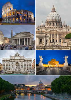
 Clockwise from top: the Colosseum, St. Peter's Basilica, Castel Sant'Angelo, Ponte Sant'Angelo, Trevi Fountain and the Pantheon | |
| Nickname(s): The Eternal City, Capital of the World, Throne of St. Peter | |
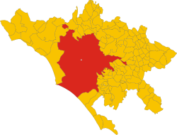
 The territory of the comune (Roma Capitale, in red) inside the Metropolitan City of Rome (Città Metropolitana di Roma, in yellow). The white area in the centre is Vatican City. | |
| Coordinates: 41°54′N 12°30′E / 41.900°N 12.500°E | |
| Country | |
| Region | Lazio (Italy) |
| Government | |
| • Type | Special Comune ("Roma Capitale") (Italy) |
| • Body | Rome City Council (Italy) |
| • Mayor (Italy) | Virginia Raggi (M5S) (Italy) |
| Area | |
| • Total | 1,285.9 km2 (496.47 sq mi) |
| Elevation | 21 m (69 ft) |
| Population (30 April 2018) | |
| • Rank | 1st, Italy (4th in EU) |
| • Density | 2,236/km2 (5,790/sq mi) |
| • Comune | 2,872,800[1] (Italy) |
| • Metropolitan City | 4,355,725[2] (Italy) |
| Demonym(s) | Italian: romano (masculine), romana (feminine) Latin: Romanus English: Roman |
| Time zone | UTC+1 (CET) |
| CAP code(s) | 00100; 00118 to 00199 |
| Area code | 06 |
| Website | Comune di Roma (Italy) Vatican City State (Vatican City) |
| Official name | Historic Centre of Rome, the Properties of the Holy See in that City Enjoying Extraterritorial Rights and San Paolo Fuori le Mura |
| Reference | 91 |
| Inscription | 1980 (4th Session) |
| Area | 1,431 ha (3,540 acres) |
- ^ "Statistiche demografiche ISTAT". Archived from the original on 7 July 2017. Retrieved 14 February 2018.
- ^ Bilancio demografico Anno 2014 (dati provvisori). Provincia: Roma Archived 5 February 2015 at the Wayback Machine – Demo.istat.it


