Nowy Targ County
Nowy Targ County
Powiat nowotarski | |
|---|---|
 Location within the voivodeship | |
| Coordinates (Nowy Targ): 49°28′N 20°1′E / 49.467°N 20.017°E | |
| Country | |
| Voivodeship | Lesser Poland |
| Seat | Nowy Targ |
| Gminas | |
| Area | |
• Total | 1,474.66 km2 (569.37 sq mi) |
| Population (2006) | |
• Total | 181,878 |
| • Density | 120/km2 (320/sq mi) |
| • Urban | 53,858 |
| • Rural | 128,020 |
| Car plates | KNT |
| Website | http://www.nowotarski.pl |
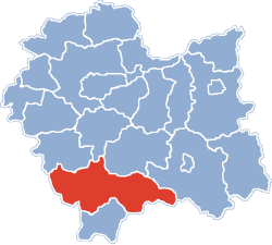
Nowy Targ County (Polish: powiat nowotarski) is a unit of territorial administration and local government (powiat) in Lesser Poland Voivodeship, southern Poland, on the Slovak border. It came into being on January 1, 1999, as a result of the Polish local government reforms passed in 1998. Its administrative seat and largest town is Nowy Targ, which lies 67 kilometres (42 mi) south of the regional capital Kraków. The county also contains the towns of Rabka-Zdrój, lying 18 km (11 mi) north of Nowy Targ, and Szczawnica, 35 km (22 mi) east of Nowy Targ.
The county covers an area of 1,474.66 square kilometres (569.4 sq mi). As of 2006 its total population is 181,878, out of which the population of Nowy Targ is 33,493, that of Rabka-Zdrój is 13,031, that of Szczawnica is 7,334, and the rural population is 128,020.
Neighbouring counties
[edit]Nowy Targ County is bordered by Sucha County to the north-west, Myślenice County to the north, Limanowa County to the north-east, Nowy Sącz County to the east and Tatra County to the south. It also borders Slovakia to the south.
Administrative division
[edit]The county is subdivided into 14 gminas (one urban, three urban-rural and 10 rural). These are listed in the following table, in descending order of population.
| Gmina | Type | Area (km2) |
Population (2006) |
Seat |
| Nowy Targ | urban | 51.1 | 33,493 | |
| Gmina Nowy Targ | rural | 208.7 | 22,070 | Nowy Targ * |
| Gmina Czarny Dunajec | urban-rural | 218.3 | 21,186 | Czarny Dunajec |
| Gmina Rabka-Zdrój | urban-rural | 69.0 | 17,190 | Rabka-Zdrój |
| Gmina Jabłonka | rural | 213.3 | 16,910 | Jabłonka |
| Gmina Raba Wyżna | rural | 88.3 | 13,525 | Raba Wyżna |
| Gmina Szaflary | rural | 54.3 | 10,227 | Szaflary |
| Gmina Łapsze Niżne | rural | 124.8 | 8,785 | Łapsze Niżne |
| Gmina Ochotnica Dolna | rural | 141.0 | 7,921 | Ochotnica Dolna |
| Gmina Szczawnica | urban-rural | 87.9 | 7,334 | Szczawnica |
| Gmina Czorsztyn | rural | 61.7 | 7,201 | Maniowy |
| Gmina Krościenko nad Dunajcem | rural | 57.3 | 6,465 | Krościenko nad Dunajcem |
| Gmina Lipnica Wielka | rural | 67.5 | 5,592 | Lipnica Wielka |
| Gmina Spytkowice | rural | 32.2 | 3,979 | Spytkowice |
| * seat not part of the gmina | ||||
References
[edit]External links
[edit] Media related to Powiat nowotarski at Wikimedia Commons


