Nodeland
Nodeland | |
|---|---|
Village | |
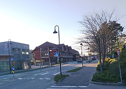
 View of the village | |
| Coordinates: 58°09′18″N 07°50′08″E / 58.15500°N 7.83556°E | |
| Country | Norway |
| Region | Southern Norway |
| County | Agder |
| Municipality | Kristiansand |
| Area | |
| • Total | 1.26 km2 (0.49 sq mi) |
| Elevation | 24 m (79 ft) |
| Population (2015)[1] | |
| • Total | 2,208 |
| • Density | 1,752/km2 (4,540/sq mi) |
| Time zone | UTC+01:00 (CET) |
| • Summer (DST) | UTC+02:00 (CEST) |
| Post Code | 4645 Nodeland |
Nodeland is a village in Kristiansand municipality in Agder County, Norway. Nodeland was the administrative centre of former Songdalen municipality which was merged into Kristiansand in 2020. The village is located about 10 kilometres (6.2 mi) northwest of the city center of Kristiansand. The village is the main urban area of Songdalen area, surrounded by several smaller villages such as Nodelandsheia, Brennåsen, Volleberg, and Hortemo.[3]
Nodeland Station is a railway station along the Sørlandet Line. All trains between Kristiansand and Stavanger (except overnight trains) stop in the village at this station. Greipstad Church is also located in Nodeland and it was the main church for the municipality.
The 1.26-square-kilometre (310-acre) village has a population (2015) of 2,208 which gives the village a population density of 1,752 inhabitants per square kilometre (4,540/sq mi).[1]
References
[edit]- ^ a b c Statistisk sentralbyrå (1 January 2015). "Urban settlements. Population and area, by municipality".
- ^ "Nodeland, Songdalen (Vest-Agder)". yr.no. Retrieved 11 January 2017.
- ^ Store norske leksikon. "Nodeland" (in Norwegian). Retrieved 11 January 2017.

