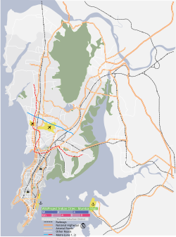
Nagpada
Appearance
This article needs additional citations for verification. (September 2014) |
Nagpada | |
|---|---|
Neighbourhood | |
Location of Nagpada in Mumbai | |
| Coordinates: 18°57′53″N 72°49′50″E / 18.96472°N 72.83056°E | |
| Country | India |
| State | Maharashtra |
| District | Mumbai City |
| City | Mumbai |
| Government | |
| • Type | Municipal Corporation |
| • Body | Brihanmumbai Municipal Corporation (MCGM) |
| Languages | |
| • Official | Marathi |
| Time zone | UTC+5:30 (IST) |
| PIN | 400008 |
| Area code | 022 |
| Civic agency | BMC |
Nagpada is a neighbourhood in South Mumbai.
The place derives its name from a local Shiva temple, and abode of Naag or the snake wound around Shiva's neck.[1] It has a community basketball court.[2]
In 2005, Nagpada was the location of the Sadaf Manzil building collapse.[3]
In April 2018, the Nagpada junction was beautified with a 25 metre national flag along with a mural dedicated to Bharat Ratna Abul Kalam Azad.[4] The area was a meeting point for pre-independence gatherings and has witnessed many political movements during the pre-independence era. It was designed by architect Hafeez Contractor and inaugurated by Mumbai Mayor Vishwanath Mahadeshwar.
References
[edit]- ^ "Violence once ruled in at Nagpada". The Times of India. 24 May 2007. Retrieved 17 April 2014.
- ^ Burke, Jason (18 November 2011). "Muslim basketball team shows India that Nagpada girls can jump". The Guardian. Mumbai. Retrieved 31 July 2015.
- ^ Tatke, Sukhada (14 August 2008). "Building collapses due to poor condition; 21 killed | Mumbai News - Times of India". The Times of India. Retrieved 10 May 2020.
- ^ Deshpande, Tanvi (22 February 2019). "Nagpada junction beautified, mural for Maulana Azad installed". The Hindu. Retrieved 10 May 2020.
