Merikarvia
Merikarvia
Sastmola | |
|---|---|
Municipality | |
| Merikarvian kunta Sastmola kommun | |
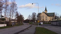
 The town center along the Kauppatie street | |
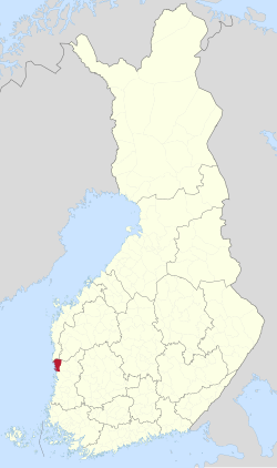
 Location of Merikarvia in Finland | |
| Coordinates: 61°51.5′N 021°30′E / 61.8583°N 21.500°E | |
| Country | |
| Region | Satakunta |
| Sub-region | Pori sub-region |
| Charter | 1639 |
| Government | |
| • Municipal manager | Juha Vasama |
| Area (2018-01-01)[1] | |
| • Total | 1,246.22 km2 (481.17 sq mi) |
| • Land | 446.28 km2 (172.31 sq mi) |
| • Water | 800.2 km2 (309.0 sq mi) |
| • Rank | 194th largest in Finland |
| Population (2024-08-31)[2] | |
| • Total | 2,918 |
| • Rank | 218th largest in Finland |
| • Density | 6.54/km2 (16.9/sq mi) |
| Population by native language | |
| • Finnish | 96.3% (official) |
| • Swedish | 0.5% |
| • Others | 3.3% |
| Population by age | |
| • 0 to 14 | 13.9% |
| • 15 to 64 | 50.6% |
| • 65 or older | 35.5% |
| Time zone | UTC+02:00 (EET) |
| • Summer (DST) | UTC+03:00 (EEST) |
| Climate | Dfc |
| Website | www.merikarvia.fi |
Merikarvia (Finnish: [ˈmeriˌkɑrʋiɑ]; Swedish: Sastmola) is a municipality in Finland. It is located in the Satakunta region. The neighboring municipalities are Isojoki, Kristinestad, Pomarkku, Pori and Siikainen.
The municipality has a population of 3,169 (2024)[2] and it covers an area of 1,246.22 square kilometres (481.17 sq mi), of which 800.2 km2 (309.0 sq mi) is water.[1] The population density is 6.54 inhabitants per square kilometre (16.9/sq mi).
The municipality is unilingually Finnish. The coastline was formerly Swedish-speaking. Merikarvia is known for the Oura Archipelago, which is part of the Bothnian Sea National Park.
History
[edit]The area has been inhabited since as early as 1800 BC.[citation needed] There are grave sites from the Bronze and Iron Ages within the municipality. Most of the cairns are located in Tuorila village located east of the municipal center.
The area of Merikarvia was initially held by the people of Sastamala (Karkku and Tyrvää) as hunting grounds, which is the origin of the Swedish name Sastmola. The name was first mentioned in 1303 as Sastamall.[5]
The birth of the earliest villages in Merikarvia - Kasala, Riispyy, Alakylä, Ylikylä and Köörtilä - is dated to between the 13th and 14th centuries.
Merikarvia was a part of the Ulvila parish until 1639.[6] Municipal administration was adopted in 1865.[7] Siikainen became a chapel community under Merikarvia in 1772 and was separated from Merikarvia as a parish in 1861[8] and as a municipality in 1871.[9]
The first church in Merikarvia was built in 1776 and was named after the queen consort of Sweden at the time, Sofia Magdalena. The church, still in use today, was finished in 1899.
As a coastal municipality, Merikarvia largely lived from the sea until modern times. Fishing, sawmills and shipyards were common businesses until the end of the 19th century.
Language and dialect
[edit]Like neighboring Ahlainen (Vittisbofjärd), Merikarvia was originally predominantly Swedish-speaking due to the Swedish settlement in the area during the Middle Ages. The Swedish language mostly disappeared from the area in the early 20th century, mainly remaining in the village of Kasala (Kasaböle) near the border with Sideby. Kasala became a majority Finnish-speaking village between the 20th and 21st centuries.[10]
A Swedish-language school was active in Kasala from 1897 until 1967.[11]
The Finnish dialect of Merikarvia is a southwestern dialect, similar to the other dialects of northern Satakunta.[12] The dialects of Merikarvia and Ahlainen are among the few dialects of Finnish where the sound /d/ is used in native words (e.g. lähde), as in standard Finnish. Most other dialects of the area use /r/ in its place.[13]
Politics
[edit]This section needs to be updated. (May 2024) |
Results of the 2011 Finnish parliamentary election in Merikarvia:
- Centre Party 35.7%
- True Finns 23.7%
- Social Democratic Party 18.6%
- National Coalition Party 11.3%
- Left Alliance 6.1%
- Christian Democrats 2.6%
- Green League 1.7%
Sights
[edit]- Lankoski rapids
- The church of Merikarvia
- Oura Archipelago[citation needed]
- Krookka marina [14]
References
[edit]- ^ a b "Area of Finnish Municipalities 1.1.2018" (PDF). National Land Survey of Finland. Retrieved 30 January 2018.
- ^ a b c "Finland's preliminary population figure was 5,625,011 at the end of August 2024". Population structure. Statistics Finland. 24 September 2024. ISSN 1797-5395. Retrieved 25 September 2024.
- ^ "Population according to age (1-year) and sex by area and the regional division of each statistical reference year, 2003–2020". StatFin. Statistics Finland. Retrieved 2 May 2021.
- ^ a b "Luettelo kuntien ja seurakuntien tuloveroprosenteista vuonna 2023". Tax Administration of Finland. 14 November 2022. Retrieved 7 May 2023.
- ^ "SuomalainenPaikannimikirja_e-kirja_kuvallinen.pdf" (PDF). kaino.kotus.fi (in Finnish). p. 404. Retrieved 30 December 2022.
- ^ "Suomen Sukututkimusseura". hiski.genealogia.fi (in Finnish). Retrieved 30 December 2022.
- ^ "Historia - Merikarvia". merikarvia.fi (in Finnish). Retrieved 30 December 2022.
- ^ "Suomen Sukututkimusseura". hiski.genealogia.fi (in Finnish). Retrieved 30 December 2022.
- ^ "150 -juhlavuosi - Siikainen". siikainen.fi (in Finnish). Retrieved 30 December 2022.
- ^ "Dialekter och småstadsspråk - 1683.pdf" (PDF). sls.fi (in Swedish). Retrieved 30 December 2022.
- ^ "Kasaböle svenska folkskola". sydaby.eget.net (in Swedish). Retrieved 30 December 2022.
- ^ "Lounaismurteiden alue". sokl.uef.fi (in Finnish). Archived from the original on 7 October 2019. Retrieved 30 December 2022.
- ^ "Kartta 65: (pata:) padan, palan, paran, paan jne. - Kettunen: Suomen murteet". kettunen.fnhost.org (in Finnish). Retrieved 30 December 2022.
- ^ "Krookan vierassatama - Krookka Guest Harbor". Merikarvia (in Finnish). Retrieved 21 August 2024.
External links
[edit]![]() Media related to Merikarvia at Wikimedia Commons
Media related to Merikarvia at Wikimedia Commons
- Municipality of Merikarvia – Official website

