Gilan-e Gharb
Gilan-e Gharb
Persian: گيلانغرب | |
|---|---|
City | |
| Coordinates: 34°08′26″N 45°55′06″E / 34.14056°N 45.91833°E[1] | |
| Country | Iran |
| Province | Kermanshah |
| County | Gilan-e Gharb |
| District | Central |
| Elevation | 810 m (2,660 ft) |
| Population (2016)[2] | |
• Total | 22,331 |
| Time zone | UTC+3:30 (IRST) |
| Area code | 0834 |
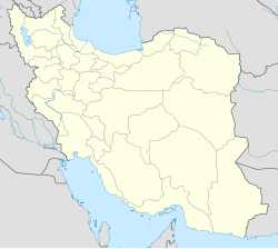
Gilan-e Gharb (Persian: گيلانغرب)[a] is a city in the Central District of Gilan-e Gharb County, Kermanshah province, Iran, serving as capital of both the county and the district.[4] The city is populated by Kurds from the Kalhor tribe.[5]
Demographics
[edit]Population
[edit]At the time of the 2006 National Census, the city's population was 19,431 in 4,620 households.[6] The following census in 2011 counted 20,922 people in 5,504 households.[7] The 2016 census measured the population of the city as 22,331 people in 6,652 households.[2]
Infrastructure
[edit]Roads
[edit]The main access road is the Gilan-e Gharb-Eslamabad-e Gharb route connecting it to Kermanshah.[8][9] It is also located on the Qasr-e Shirin-Ilam road which has become a shorter route after the paving of the nawdar rural road in 2015.[10][11][12] Other routes include the Gilan-e Gharb-Sarpol-e Zahab and Gilan-e Gharb-Sumar roads.[10]
See also
[edit]Notes
[edit]References
[edit]- ^ OpenStreetMap contributors (13 July 2023). "Gilan-e Gharb, Gilan-e Gharb County" (Map). OpenStreetMap (in Persian). Retrieved 13 July 2023.
- ^ a b "Census of the Islamic Republic of Iran, 1395 (2016)". AMAR (in Persian). The Statistical Center of Iran. p. 05. Archived from the original (Excel) on 3 April 2022. Retrieved 19 December 2022.
- ^ Gilan-e Gharb can be found at GEOnet Names Server, at this link, by opening the Advanced Search box, entering "-3064347" in the "Unique Feature Id" form, and clicking on "Search Database".
- ^ Habibi, Hassan (21 June 1369). "Approval of the organization and chain of citizenship of the elements and units of the national divisions of Bakhtran province, centered in the city of Bakhtran". Research Center of the System of Laws of the Islamic Council of Farabi Mobile Library (in Persian). Ministry of Interior, Defense Political Commission of the Government Board. Archived from the original on 6 February 2013. Retrieved 29 January 2024.
- ^ "Gilān-e Gharb". Iran Atlas. 2017. Retrieved 28 May 2022.
- ^ "Census of the Islamic Republic of Iran, 1385 (2006)". AMAR (in Persian). The Statistical Center of Iran. p. 05. Archived from the original (Excel) on 20 September 2011. Retrieved 25 September 2022.
- ^ "Census of the Islamic Republic of Iran, 1390 (2011)". Syracuse University (in Persian). The Statistical Center of Iran. p. 05. Archived from the original (Excel) on 18 January 2023. Retrieved 19 December 2022.
- ^ "مسیر گیلانغرب به اسلام آباد غرب | فاصله گیلانغرب تا اسلام آباد غرب روی نقشه".
- ^ "آغاز اجرایی طرح روکش آسفالت محورهای مواصلاتی گیلانغرب". 6 July 2022.
- ^ a b "ایران شناسی (144): گیلانغرب". 27 November 2020.
- ^ "راهنمای سفر به گیلانغرب 1401 | گیلانِ غربِ کشور را بشناسید | زیگو". 22 June 2022.
- ^ "مسیر ایلام به گیلانغرب | فاصله ایلام تا گیلانغرب روی نقشه".

