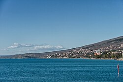
Dramalj
This article contains promotional content. (March 2019) |
This article needs additional citations for verification. (September 2012) |
Dramalj | |
|---|---|
Village | |
 Dramalj coast | |
 | |
| Country | |
| Area | |
| • Total | 5.8 km2 (2.2 sq mi) |
| Population (2021)[2] | |
| • Total | 1,366 |
| • Density | 240/km2 (610/sq mi) |
| Time zone | UTC+1 (CET) |
| • Summer (DST) | UTC+2 (CEST) |
| Area code | 051 |
| Website | tzm-dramalj |
Dramalj is a small fishing village in Croatia. It is part of the town of Crikvenica, extending from the neighborhood Crni mol to the tourist complex Kačjak. A tourism boom in the nearby Crikvenica area and the rest of the Croatian Littoral in the 19th century drove the development of Dramalj.
The village is home to the Dramalj Culture Hall, where traditional carnival feasts are held during the winter.
History
[edit]
Dramalj was first mentioned in the 18th century, when it was named Zagorje - Dramalj. In the beginning, it was a fishing port with olive groves, most of which were owned by the inhabitants of Tribalj Valley.
There are ruins of an ancient Liburnian hill fort enclosed with a dry-stone dyke above Dramalj. Amphorae found around the Kačjak Peninsula are evidence of an ancient Roman port located there at the time. Another one of Dramalj's landmarks is a "toš", an old olive press.
In the Austro-Hungarian times, Dramalj was part of Sveta Jelena County (St. Helen), which was founded in 1809.[3] The parish house and the Church of St. Helen[4] were built after 1812. The church was built on the foundations of an old chapel, when Dramalj belonged to Belgrad parish.[3] G. Capovilla, a stone carver from Rijeka, made the altar in 1796. The construction of the church was financed by the parish and initiated by Mate Balas, then parish priest. The interior of the church was refurbished in the 19th century, the pulpit in 1837 and the main altar in 1845. The name of the village was soon after changed to Sveta Jelena. After the World War II, the former name Dramalj was restored.
The Culture Hall is located in the vicinity of the church. In 1939, the building was home to the first public library in Dramalj.
Climate
[edit]The North Adriatic, especially in this part of the Quarner Riviera experiences a mild Mediterranean climate with some continental influence. The summers are sunny, dry and hot, while the winters are rainy and relatively mild with characteristic winds. The average annual air temperature is 14.2 °C. The coldest month is January, while the hottest one is July.
Average cloud cover in Dramalj is 0.51 (5.1 tenths of obscured sky), varying from 0.33 to 0.62. Average annual relative humidity is 70%, while the peak rainy period is in October and November. Air pressure averages 761.8 millimetres of mercury (1,015.6 hPa).
Bora and jugo are the predominant winds in the area, while Ostro, maestral and levant are also present. Bora typically blows from November to February, peaking in strength in January, while jugo is most frequently experienced from May to August with the average maximum in July. Ostro, a southern wind, reaches its maximum in November. A particular climatic feature is the so-called "kalma", characterized by calm weather without any wind.[citation needed]
The soil in Dramalj area is mostly composed of porous karst (limestone). The sea is shallow, even at a considerable distance from the coast. Wave strength is generally minor, allergens in air scant, while the salt and ozone content in the air is increased with minimal aerobic pollution.[citation needed]
The area features climatic and bioclimatic conditions favorable for thalassotherapy and health tourism.[citation needed]
Notable Attractions
[edit]
Notable attractions in Dramalj include:
- A motorized train for children
- Restaurants that offer Croatian cuisine and seafood[5]
- The Kačjak tourist complex, composed of bungalows and pavilions.
- The Dramalj Culture Hall[6]
- Kacjak Beach
- Kacjak East Beach
- Beach Omorika[7]
- Lanterna Beach[8]
- Pazdehova Beach
- Riviera Beach
- Vali Beach
See also
[edit]References
[edit]- ^ Register of spatial units of the State Geodetic Administration of the Republic of Croatia. Wikidata Q119585703.
- ^ "Population by Age and Sex, by Settlements" (xlsx). Census of Population, Households and Dwellings in 2021. Zagreb: Croatian Bureau of Statistics. 2022.
- ^ a b "Povijest | Crikvenica". www.rivieracrikvenica.com. Retrieved 2023-05-24.
- ^ Toš, Marjan (2012-01-23). Zgodovinski spomin na prekmurske Jude. ZRC SAZU, Založba ZRC. ISBN 978-961-05-0334-7.
- ^ "Restaurant".
- ^ juma (2024-01-30). "Dramalj, Croatia: Travel Guide & Best Beaches!". PlacesofJuma. Retrieved 2024-03-29.
- ^ juma (2024-01-30). "Dramalj, Croatia: Travel Guide & Best Beaches!". PlacesofJuma. Retrieved 2024-03-29.
- ^ juma (2024-01-30). "Dramalj, Croatia: Travel Guide & Best Beaches!". PlacesofJuma. Retrieved 2024-03-29.
External links
[edit]- Tourist association of Dramalj (in Croatian)