Dongji Island
Native name: 東吉嶼 | |
|---|---|
 | |
 | |
| Geography | |
| Location | southeastern Wangan Township, Penghu County (the Pescadores), Republic of China (Taiwan) |
| Coordinates | 23°15′5.75″N 119°40′21.41″E / 23.2515972°N 119.6726139°E |
| Area | 1.7712 km2 (0.6839 sq mi)[1][2] |
| Highest elevation | 47 m (154 ft)[1] |
| Administration | |
Republic of China (Taiwan) | |
| Province | Taiwan (streamlined) |
| County | Penghu |
| Rural Township | Wangan |
| Demographics | |
| Population | 261 (November 2017)[3] |
| Pop. density | 147.3577/km2 (381.6547/sq mi) |
| Additional information | |
| Time zone | |
You can help expand this article with text translated from the corresponding article in Chinese. (August 2019) Click [show] for important translation instructions.
|
Dongji Island[4] / Dongji Islet[5][6] / Tungchi Island[7][8] (Chinese: 東吉嶼; Hanyu Pinyin: Dōngjí Yǔ; Tongyong Pinyin: Dongjí Yǔ; Wade–Giles: Tung1-chi2 Yü3; Pe̍h-ōe-jī: Tang-kiat-sū) is an island in Dongji Village (東吉村), Wangan Township, Penghu County (the Pescadores), Taiwan.[9] Dongji Island has also been known as Nandongyu (南東嶼).[10]: 19
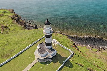
The island is the site of the Dongji Island Lighthouse (Dongji Lighthouse).[5][11]
History
[edit]

A temple for Wang Ye worship on the island was built during the Jiaqing era and restored in 1872.[12]
Dongji Island Lighthouse was built in 1911 during the period of Japanese rule of Taiwan.[13]
In June 2012, fisherman Wang Chiu-tang (王秋堂) discovered a fossilized ivory tusk in a trench near the island 200 m (660 ft) below sea level.[14]
In June 2014, Dongji Island was made part of the new South Penghu Marine National Park.[15]
In May 2016, a ferry service between Tainan and Dongji Island had its maiden voyage.[16] The trip to Tainan takes about two and a half hours.[1]
On July 1, 2016, the Hsiung Feng III missile mishap occurred in the waters southeast of Dongji Island.
In June 2017, a tornado-like twister was reported in the waters off Dongji Island, which is an occasional occurrence in the area's weather patterns.[17]
On January 10, 2018, the Chia Ming Lun (嘉明輪) cargo ship ran aground and sank near Dongji Island. The ship and its cargo was left unsalvaged.[18]
On October 4, 2019, over 800 kg (1,800 lb) of abandoned fishing nets were removed from coral reef near Dongji Island.[19]
Geography
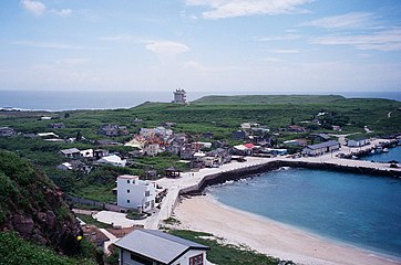
[edit]Dongji Island's village is located near the middle of the island in an area that was previously underwater.[1] There are two mountains on the island- in the north is Hutoushan (虎頭山), in the south is Baguashan (八卦山).[20] The smaller formerly inhabited Chutou Islet (Jotō-shō, Hotozan-to; 鋤頭嶼) is located to the immediate northwest of Dongji Island.[1][20][21]
The marine area of Taijiang National Park covers a band extending 20 metres (66 ft) from the shore of Taiwan Island and 54 km (34 mi) long from Yanshui River to Dongji Island, an area of 344.05 km2 (132.84 sq mi).[22]
Climate
[edit]Dongji Island has a tropical climate close to the humid subtropical boundary. Being an offshore island in the shallow Taiwan Strait, the location has lower diurnal temperature variation than either mainland Taiwan or the Asian continental landmass to its west. The island is also a lot drier and sunnier than the Taiwanese mainland. The vast majority of rain falls in summer as the East Asian monsoon penetrates the high-pressure systems otherwise dominating the area. Winters are dry with comfortable weather for outdoor activities, although cloudier than the low rainfall amounts would suggest.
| Climate data for Dongji Island (Dongjidao) (1991–2020 normals, extremes 1962–present) | |||||||||||||
|---|---|---|---|---|---|---|---|---|---|---|---|---|---|
| Month | Jan | Feb | Mar | Apr | May | Jun | Jul | Aug | Sep | Oct | Nov | Dec | Year |
| Record high °C (°F) | 28.1 (82.6) |
28.7 (83.7) |
31.2 (88.2) |
32.1 (89.8) |
36.9 (98.4) |
35.2 (95.4) |
35.7 (96.3) |
35.3 (95.5) |
34.3 (93.7) |
34.2 (93.6) |
31.0 (87.8) |
29.6 (85.3) |
36.9 (98.4) |
| Mean daily maximum °C (°F) | 20.0 (68.0) |
20.6 (69.1) |
23.2 (73.8) |
26.1 (79.0) |
28.5 (83.3) |
29.9 (85.8) |
31.0 (87.8) |
30.8 (87.4) |
30.0 (86.0) |
27.7 (81.9) |
25.1 (77.2) |
21.7 (71.1) |
26.2 (79.2) |
| Daily mean °C (°F) | 18.1 (64.6) |
18.5 (65.3) |
20.7 (69.3) |
23.6 (74.5) |
26.0 (78.8) |
27.8 (82.0) |
28.7 (83.7) |
28.4 (83.1) |
27.6 (81.7) |
25.5 (77.9) |
23.1 (73.6) |
19.9 (67.8) |
24.0 (75.2) |
| Mean daily minimum °C (°F) | 16.7 (62.1) |
16.9 (62.4) |
18.9 (66.0) |
21.9 (71.4) |
24.4 (75.9) |
26.2 (79.2) |
26.9 (80.4) |
26.6 (79.9) |
26.0 (78.8) |
24.3 (75.7) |
21.8 (71.2) |
18.6 (65.5) |
22.4 (72.3) |
| Record low °C (°F) | 8.0 (46.4) |
8.4 (47.1) |
8.8 (47.8) |
11.2 (52.2) |
17.2 (63.0) |
19.6 (67.3) |
21.4 (70.5) |
21.4 (70.5) |
19.6 (67.3) |
16.4 (61.5) |
14.0 (57.2) |
9.2 (48.6) |
8.0 (46.4) |
| Average precipitation mm (inches) | 21.8 (0.86) |
28.9 (1.14) |
38.4 (1.51) |
70.8 (2.79) |
117.3 (4.62) |
183.9 (7.24) |
189.9 (7.48) |
243.3 (9.58) |
108.2 (4.26) |
35.6 (1.40) |
32.9 (1.30) |
26.1 (1.03) |
1,097.1 (43.21) |
| Average precipitation days (≥ 0.1 mm) | 4.2 | 4.0 | 4.9 | 6.8 | 7.9 | 9.8 | 9.2 | 10.0 | 5.6 | 1.8 | 2.6 | 2.6 | 69.4 |
| Average relative humidity (%) | 78.0 | 79.4 | 78.7 | 80.0 | 81.8 | 83.9 | 82.1 | 83.3 | 81.0 | 77.2 | 77.3 | 76.7 | 80.0 |
| Mean monthly sunshine hours | 119.0 | 110.7 | 149.2 | 171.5 | 202.4 | 215.3 | 259.8 | 232.4 | 229.4 | 214.5 | 149.6 | 121.1 | 2,174.9 |
| Source: Central Weather Bureau[23][24][25][26][27] | |||||||||||||
Gallery
[edit]-
Dongji Fishing Harbor
-
Dongji Island Lighthouse
See also
[edit]References
[edit]- ^ a b c d e 地理環境位置. Marine National Park Headquarters (in Chinese (Taiwan)). 14 February 2018. Retrieved 3 November 2019.
東吉嶼位於望安鄉的東南方,東經119°40'18.79,北緯23°15'21.09面積1.7712平方公里,海拔高度最高點約47公尺。{...}中間較低處為主要聚落集中區,現在村落的位置是早年的海底,因陸地逐漸抬升,村民逐漸往現在的港邊居住,{...}因島嶼位置靠近臺灣(臺南),航程僅約2小時30分,{...}附屬島嶼-鋤頭嶼 附屬島嶼-鋤頭嶼 鋤頭嶼,地處東經11 9°39'33.48,北緯23°15'45.12,位在東吉嶼西北方的方山小島,主要為柱狀玄武岩及火山角礫岩所組成,
- ^ 澎湖的島嶼. 澎湖國家風景區管理處 (in Chinese (Taiwan)). Retrieved 3 November 2019.
# 行政區域 島嶼名稱 經度 緯度 面積 (平方公里) 有人居住 (*) {...}75 望安鄉 東吉嶼 119° 40' 18.79" 23° 15' 21.09" 1.7712 *
- ^ 最新人口統計. 西嶼鄉戶政事務所 Xiyu Township Household Registration Office, Penghu County (in Chinese (Taiwan)). November 2017. Retrieved 2 November 2019.
2017年11月 各里人口數、戶數統計 村里 鄰數 戶數 男 女 人口總數{...}東吉村 21 153 143 118 261
- ^ "How to Get to the South Penghu Marine National Park?". Marine National Park Headquarters. 1 December 2017. Retrieved 3 November 2019.
Direct Sea Transportation: About 2.5 hours of voyage from Tainan to Dongji Island; currently, there are privately operated passenger liners sailing off at fixed times; there are still no fixed transportation boats towards Dongyuping Island and Xiyuping Island.
- ^ a b "PENGHU From island to island" (PDF). Penghu County Government. 2010s. p. 2. Retrieved 2 November 2019.
Dongji Lighthouse Dongji Islet Dongji Port Dongji Island Dongji Island is close to Tainan, most of its population has moved to southern Taiwan.
- ^ Stephen Keeling; Brice Minnigh (2007). The Rough Guide to Taiwan. Rough Guides. London. p. 445 – via Internet Archive.
Dongji Islet
{{cite book}}: CS1 maint: location missing publisher (link) - ^ Robert Storey (September 1998). "Taiwan". Lonely Planet (4 ed.). Hong Kong. p. 296 – via Internet Archive.
Tungchi Island
- ^ Robert Kelly; Joshua Samuel Brown, eds. (March 2011). Taiwan. Lonely Planet (8 ed.). Singapore. p. 292. ISBN 9781741790436.
Tungchi Island
{{cite book}}: CS1 maint: location missing publisher (link) - ^ 澎湖縣土地段名代碼表 (in Chinese (Taiwan)). Department of Land Administration. 15 January 2008. Retrieved 3 November 2019.
地政事務所名稱(代碼) 澎湖(XA) 鄉鎮市區名稱(代碼) 望安鄉(05) 段 小段 代碼 備註{...}東吉 0077
- ^ 臺灣歷史地圖 增訂版 [Taiwan Historical Maps, Expanded and Revised Edition] (in Chinese (Taiwan)). Taipei: National Museum of Taiwan History. February 2018. p. 19. ISBN 978-986-05-5274-4.
福爾摩沙島與澎湖群島圖{...}Q. 南東嶼(東吉嶼)
- ^ "Dongjiyu Lighthouse". Penghu National Scenic Area Administration. Retrieved 3 November 2019.
Dongjiyu lighthouse is situated on the edge of the Dongjiyu north tip in Wangan Township, Penghu County.
- ^ 啟明宮. Marine National Park Headquarters (in Chinese (Taiwan)). 21 August 2015. Retrieved 3 November 2019.
東吉嶼的信仰中心是啟明宮,供奉徐府王爺,王爺誕辰為農曆十一月廿七日。由廟內刻有「高山聖吉」的牌匾可推測其約在清嘉慶年間(西元1808年至西元1811年)及同治11年(西元1872年)分別修建,
- ^ 東吉燈塔. Marine National Park Headquarters (in Chinese (Taiwan)). 21 August 2015. Retrieved 3 November 2019.
所以日本人在明治44年(西元1911年)興建燈塔,
- ^ Tsai Wen-chu (23 June 2012). "Fisherman gives fossil ivory tusk to Matsu temple". Taipei Times. Retrieved 3 November 2019.
A fisherman who dredged up a petrified ivory tusk from the ocean trench off Dongji Island (東吉嶼)
- ^ Stacy Hsu (6 June 2014). "New national park planned for Penghu". Taipei Times. Retrieved 3 November 2019.
The new park, situated to the east of Wang-an (望安) and Cimei (七美) islands to the south of the Penghu islands, encompasses Dongji (東吉), Dongyuping (東嶼坪), Siji (西吉) and Siyuping (西嶼坪) islets, as well as their surrounding waters.
- ^ Chang Jung-hsiang; Kuo Chung-han (29 May 2016). "Ferry service between Tainan and Penghu's Dongji kicks off". Focus Taiwan. Retrieved 3 November 2019.
- ^ Matthew Strong (13 June 2017). "Twister hovers off Taiwanese island for 6 minutes". Taiwan News. Retrieved 3 November 2019.
- ^ "Over 200 packages lost at sea after ship sinks, including NT$6,000 parcel". Taiwan News. 16 January 2018. Retrieved 3 November 2019.
On Jan. 10, the Chia Ming Lun (嘉明輪) cargo ship ran aground and sank near Dongji Island (東吉嶼) after the vessel had become entangled in an abandoned fishing net. The owner then decided not to salvage the submerged ship, thus leaving 931 registered letters and 231 packages in a watery grave at the bottom of the sea.
- ^ Chen Chi-ching; Chi Jo-yao (4 October 2019). "Over 800 kg of ghost nets removed from Penghu coral reefs". Focus Taiwan. Retrieved 3 November 2019.
- ^ a b 望安鄉 東吉村. 澎湖縣望安鄉公所 Wangan Township Hall, Penghu County (in Chinese (Taiwan)). 10 August 2017. Retrieved 3 November 2019.
東吉島西北側有「鋤頭嶼」,西約距三浬則為「西吉島」,原有人居住,目前已成無人島。{...}在島之南方有座「虎頭山」﹔北方有座「八卦山」﹔
- ^ 海管處帶您看見澎湖南方四島. Marine National Park Headquarters (in Chinese (Taiwan)). 14 March 2016. Retrieved 3 November 2019.
圖3、玄武岩方山島嶼散落於海面上,為數百年前先人橫渡黑水溝的重要指標 (圖上方為東吉嶼、下方為鋤頭嶼)。
- ^ "National Parks of Taiwan - Taijiang". np.cpami.gov.tw. Construction and Planning Agency, Ministry of the Interior, R.O.C. 2014. Archived from the original on 2016-05-24. Retrieved 2017-10-16.
- ^ "Monthly Mean". Central Weather Bureau. Retrieved 9 February 2023.
- ^ "氣象站各月份最高氣溫統計" (PDF) (in Chinese). Central Weather Bureau. Retrieved 9 February 2023.
- ^ "氣象站各月份最高氣溫統計(續)" (PDF) (in Chinese). Central Weather Bureau. Retrieved 9 February 2023.
- ^ "氣象站各月份最低氣溫統計" (PDF) (in Chinese). Central Weather Bureau. Retrieved 9 February 2023.
- ^ "氣象站各月份最低氣溫統計(續)" (PDF) (in Chinese). Central Weather Bureau. Retrieved 9 February 2023.
External links
[edit]- 【MIT台灣誌 #376】水藍草綠岩屋-澎湖望安東吉島 ('Made in Taiwan Annals of Taiwan #376: Blue Waters, Green Grass and Stone Caverns- Dongji Island, Wangan, Penghu') (in Chinese)


