Bulphan
This article needs additional citations for verification. (September 2014) |
| Bulphan | |
|---|---|
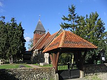
 The entrance to the village of Bulphan | |
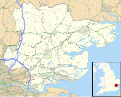
Location within Essex | |
| Area | 0.537 km2 (0.207 sq mi) |
| Population | 774 (2021 census) |
| • Density | 1,441/km2 (3,730/sq mi) |
| OS grid reference | TQ645865 |
| Unitary authority | |
| Ceremonial county | |
| Region | |
| Country | England |
| Sovereign state | United Kingdom |
| Post town | UPMINSTER |
| Postcode district | RM14 |
| Dialling code | 01375 |
| Police | Essex |
| Fire | Essex |
| Ambulance | East of England |
| UK Parliament | |
Bulphan (Bul-ven ) is a village and former civil parish in the borough of Thurrock in Essex and one of the traditional (Church of England) parishes in Thurrock. As of the 2021 census, it had a population of 774.[1]
History
[edit]In 1931 the parish had a population of 455.[2] On 1 April 1936 the parish was abolished to form Thurrock.[3]
Bulphan's original village shop closed down in 2012. However, a new community-run shop and post office opened in early 2020, in a side extension of the village hall.
Geography
[edit]Bulphan forms part of the Orsett ward of Thurrock Council, and is part of the South Basildon and East Thurrock parliamentary constituency. It is located 21 miles (34 km) east north-east of Charing Cross in London. The Upminster post town forms a long, thin protrusion eastwards over the M25 motorway and the Greater London boundary in order to include the village.
The main features of Bulphan are the Bulphan Village Hall and Park, St Mary The Virgin Church, and Bulphan Church Of England Academy Primary School. The church is a grade I listed building.[4]
Nearest places are Laindon, North Ockendon, Orsett and West Horndon.
Transport
[edit]Bulphan has two bus services: the 265, which runs on Mondays, Wednesdays and Fridays between Grays and West Horndon and the 565 to Brentwood Station via West Horndon (6 times per day, Monday to Saturday). School buses run to Shenfield School and Sockets Heath. The nearest railway station is three miles away.
Education
[edit]Primary education has been provided by the Bulphan Church of England Voluntary Controlled Primary School since 1853. Located on Fen lane, it educates around 84 pupils.
Notable people
[edit]- Charles Littlehales (1871-1945), cricketer and clergyman
- Jim Davidson (1953-), comedian
- Tony Cottee (1965-), footballer and commentator
- Mick Norcross (1963-2021) reality TV performer
References
[edit]- ^ "BULPHAN in Thurrock (East of England)". City Population. 21 March 2021. Retrieved 1 March 2024.
- ^ "Population statistics Bulphan AP/CP through time". A Vision of Britain through Time. Retrieved 24 December 2021.
- ^ "Relationships and changes Bulphan AP/CP through time". A Vision of Britain through Time. Retrieved 24 December 2021.
- ^ Historic England. "CHURCH OF ST MARY (1111617)". National Heritage List for England. Retrieved 22 April 2014.

