Trauger, Pennsylvania
Appearance
Trauger | |
|---|---|
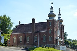
 St. Mary's Byzantine Catholic Church | |
| Coordinates: 40°13′58″N 79°27′45″W / 40.23278°N 79.46250°W | |
| Country | United States |
| State | Pennsylvania |
| County | Westmoreland |
| Elevation | 1,033 ft (315 m) |
| Time zone | UTC-5 (Eastern (EST)) |
| • Summer (DST) | UTC-4 (EDT) |
| GNIS feature ID | 1189727[1] |
Trauger is an unincorporated community and coal town in Westmoreland County, Pennsylvania, United States.
An architecturally impressive historic structure built in 1914, St. Mary's Byzantine Catholic Church is large brick building in the Spanish Renaissance style.[2]
References


