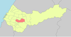
24°10′49.54″N 120°44′47.81″E / 24.1804278°N 120.7466139°E
Beitun
北屯區 | |
|---|---|
 | |
 Beitun District in Taichung City | |
| Location | Taichung, Taiwan |
| Area | |
• Total | 63 km2 (24 sq mi) |
| Population (February 2023) | |
• Total | 297,670 |
| • Density | 4,700/km2 (12,000/sq mi) |
| Website | www |
Beitun District (Chinese: 北屯區; pinyin: Běitún Qū; Wade–Giles: Pei3-t'un2 Ch'ü1; lit: northern camp) is a district in Taichung, Taiwan. Located in the northern part of the city, it is a half mountainous, half urban area. Though Beitun District used to be considered part of the countryside, the new Taiyuan Station has urbanized it considerably. The highest point of Taichung City is located in Beitun, Douliu Hill (859 m).
History
editThe district used to be part of Taichung provincial city before the merger with Taichung County to form Taichung special municipality on 25 December 2010.
Administrative divisions
editBeitun District is divided into 42 Li (里, or villages):[1]
|
|
|
Education
editSpots
editTourist attractions
edit- Beitun Wenchang Temple
- Dakeng hiking and biking trails
- Songzhu Temple
- Taichung Folklore Park
- Taichung Military Kindred Village Museum
- Yide Mansion
Transportation
editRailway
editTaichung Metro
edit- Beitun Main metro station
- Jiushe metro station
- Songzhu station
- Sihwei Elementary School metro station
- Wenxin Chongde metro station
Roads
editNotable natives
edit- Dewi Chien, singer
- Joe Cheng, model, actor and singer
See also
editReferences
edit- ^ "2014 Local Elections". Archived from the original on 2014-12-27. Retrieved 2014-12-27.
External links
editWikimedia Commons has media related to Beitun District, Taichung.
- Official website (in Chinese)