Monitoring Wetlands Ecosystems Using ALOS PALSAR (L-Band, HV) Supplemented by Optical Data: A Case Study of Biebrza Wetlands in Northeast Poland

<p>Test site on MERIS RGB (7, 5, 2) composition with transects A–B and C–D marked by the red line for which chosen AVHRR data have been transformed into T<sub>s</sub> and MERIS data into NDVI values.</p> ">
<p>Accumulated values of air temperature (Acc T).</p> ">
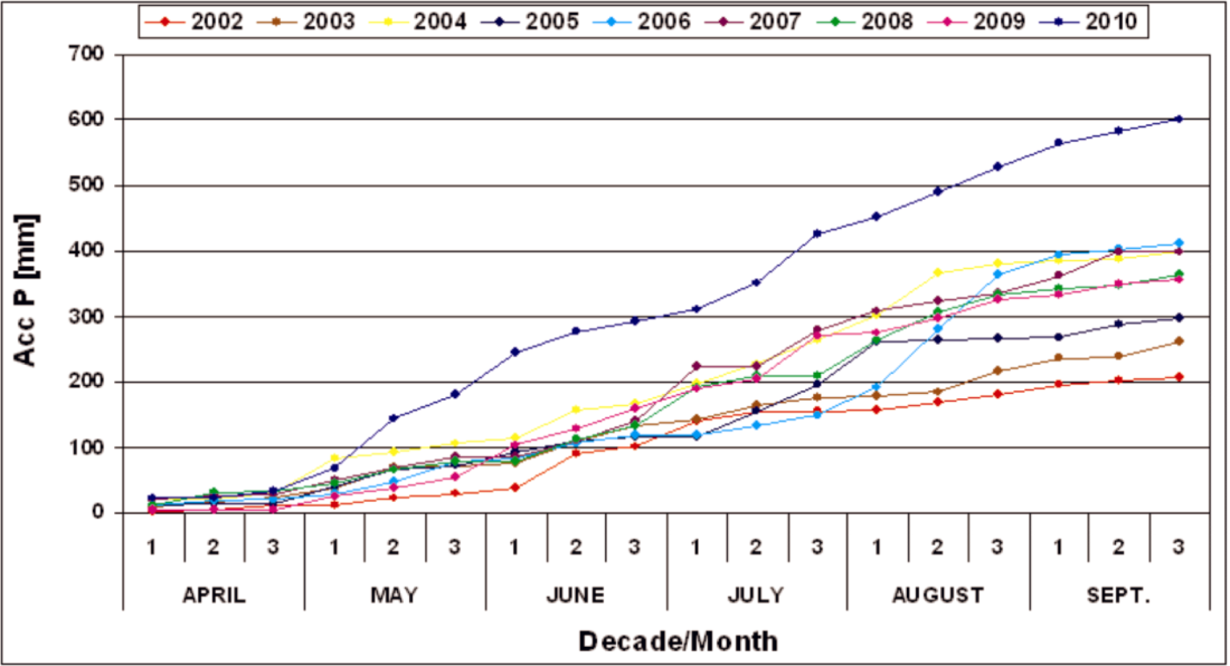
<p>Accumulated values of precipitation (Acc P).</p> ">
<p>Red, Green, Blue (RGB) (4, 2, 1) composition of AVHRR image acquired on 24 April 2008.</p> ">
<p>RGB (10, 5, 3) composition of MERIS image acquired on 25 April 2010.</p> ">
<p>PALSAR FBD HV image acquired on 12 May 2008.</p> ">
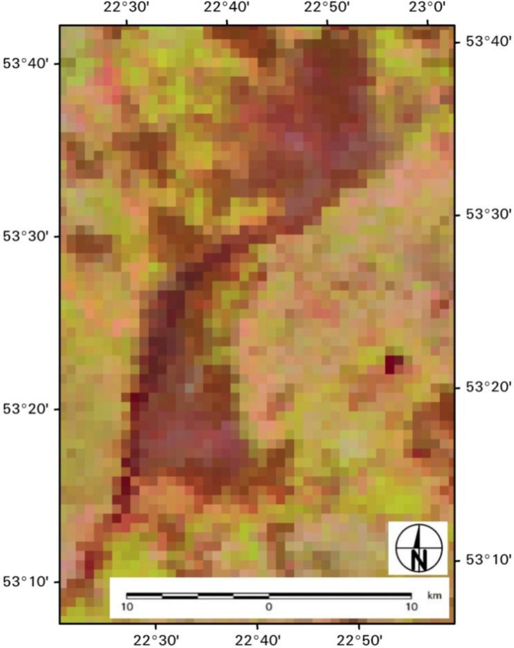
<p>Map of wetland communities classified based on PALSAR HV image registered on 12 May 2008, placed on CLC classes.</p> ">
<p>Map of wetland communities classified based on PALSAR HV image registered on 1 May 2010, placed on CLC classes.</p> ">
<p>Plot of the LAI measured <span class="html-italic">versus</span> estimated from PALSAR HV images.</p> ">
Abstract
:1. Introduction
2. Materials and Methods
2.1. Study Area
2.2. Data Acquisition
2.2.1. In-Situ Data
2.2.2. Satellite Data
2.3. Classification of Wetlands Vegetation Habitats
2.4. Assessment of LAI
2.5. Calculation of Surface Temperature Ts and NDVI
3. Results and Discussion
3.1. Wetland Habitat Types Classification Using ALOS Microwave Images
3.2. Prediction of Leaf Area Index
3.3. Ts and NDVI—Application of Optical Images
4. Conclusions
Acknowledgments
Author Contributions
Conflicts of Interest
References
- Mitsch, W.J.; Gosselink, J.G. The Value of wetlands: Importance of scale and landscape setting. Ecol. Econ 2000, 7, 25–33. [Google Scholar]
- Rodriguez-Iturbe, I.; Porporato, A. Introduction. In Ecohydrology of Water-Controlled Ecosystems: Soil Moisture and Plant Dynamics; Cambridge University Press: Cambridge, UK, 2004; pp. 6–7. [Google Scholar]
- Biebrza National Park. Available online: http://www.biebrza.org.pl/14,biebrzanski-pn.html (accessed on 24 March 2009).
- Ozesmi, S.L.; Bauer, M.E. Satellite remote sensing of wetlands. Wetl. Ecol. Manag 2002, 10, 381–402. [Google Scholar]
- Hess, L.L.; Melack, J.M.; Simonett, D.S. Radar detection of flooding beneath the forest canopy: A review. Int. J. Remote Sens 1990, 11, 1313–1325. [Google Scholar]
- Kasischke, E.S.; Bourgeau-Chavez, L.L. Monitoring South Florida wetlands using ERS-1 SAR imagery. Photogramm. Eng. Remote Sens 1997, 63, 281–291. [Google Scholar]
- Townsend, P.A.; Walsh, S.J. Modeling floodplain inundation using an integrated GIS with radar and optical remote sensing. Geomorphology 1998, 21, 295–312. [Google Scholar]
- Kushwaha, S.P.S.; Dwivedi, R.S.; Rao, B.R.M. Evaluation of various digital image processing techniques for detection of coastal wetlands using ERS-1 SAR data. Int. J. Remote Sens 2000, 21, 565–579. [Google Scholar]
- Souza-Filho, P.W.M.; Paradella, W.R.; Rodrigues, S.W.P.; Costa, F.R.; Mura, J.C.; Gonçalves, F.D. Discrimination of coastal wetland environments in the Amazon region based on multi-polarized L-band airborne Synthetic Aperture Radar imagery. Estuar. Coast. Shelf Sci 2011, 95, 88–98. [Google Scholar]
- Le Toan, T.; Beaudoin, A.; Riom, J.; Guyon, D. Relating forest biomass to SAR data. IEEE Trans. Geosci. Remote Sens 1992, 30, 403–411. [Google Scholar]
- Dabrowska-Zielinska, K.; Gruszczynska, M.; Lewinski, S.; Hoscilo, A.; Bojanowski, J. Application of remote and in situ information to the management of wetlands in Poland. J. Environ. Manag 2009, 90, 2261–2269. [Google Scholar]
- Byczkowski, A.; Okruszko, T. Restoration of protected fenlands (case study for the central basin of the Biebrza River Valley). Rocz. Akad. Rol. Pozn 2004, 25, 15–21. [Google Scholar]
- Klosowski, T. Biebrza Marshland; Janudi, M., Ed.; VOUAGER: Warsaw, Poland, 1994. [Google Scholar]
- Kundzewicz, Z.W. Ecohydrology for Sustainable Wetlands under Global Change—Data, Models, Management. In Measurement Techniques and Data Assessment in Wetlands Hydrology; Ignar, S., Nowakowski, P., Okruszko, T., Eds.; Warsaw Agricultural University Press: Warsaw, Poland, 2003; pp. 25–35. [Google Scholar]
- Zurek, S. Rzezba i Budowa Geologiczna Doliny Biebrzy. In Przyroda Biebrzanskiego Parku Narodowego; Dyrcz, A., Werpachowski, C., Eds.; Biebrzanski Park Narodowy Press: Osowiec-Twierdza, Poland, 2005; pp. 19–32. [Google Scholar]
- Sienko, A.; Grygoruk, A. Biebrzanski Park Narodowy. In Biebrzanski Park Narodowy; Sienko, A., Grygoruk, A., Eds.; Biebrzanski Park Narodowy Press: Osowiec-Twierdza, Poland, 2003; pp. 10–12. [Google Scholar]
- Dembek, W.; Oswit, J.; Rycharski, M. Torfowiska i Torfy w Pradolinie Biebrzy. In Przyroda Biebrzanskiego Parku Narodowego; Dyrcz, A., Werpachowski, C., Eds.; Biebrzanski Park Narodowy Press: Osowiec-Twierdza, Poland, 2005; pp. 33–58. [Google Scholar]
- Silakowski, M. Charakterystyka Fizyczno-Geograficzna-Klimat. In Biebrzanski Park Narodowy; Sienko, A., Grygoruk, A., Eds.; Biebrzanski Park Narodowy Press: Osowiec-Twierdza, Poland, 2003; pp. 17–22. [Google Scholar]
- LI-COR Inc. LAI-2000 Plant Canopy Analyzer; LI-COR Inc.: Lincoln, NE, USA, 1992. [Google Scholar]
- SAR-Guidebook, 1.4 Scattering Mechanisms. Available online: http://www.sarmap.ch/pdf/SAR-Guidebook.pdf (accessed on August 2009).
- Santoro, M.; Pantze, A.; Fransson, J.E.S.; Dahlgren, J.; Persson, A. Nation-wide clear-cut mapping in Sweden using ALOS PALSAR strip images. Remote Sens 2012, 4, 1693–1715. [Google Scholar]
- Cornforth, W.A.; Fatoyinbo, T.E.; Freemantle, T.P.; Pettorelli, N. Advanced land observing satellite phased array type L-band SAR (ALOS PALSAR) to inform the conservation of mangroves: Sundarbans as a case study. Remote Sens 2013, 5, 224–237. [Google Scholar]
- Whittle, M.; Quegan, S.; Uryu, Y.; Stuewe, M.; Yulianto, K. Detection of tropical deforestation using ALOS-PALSAR: A Sumatran case study. Remote Sens. Environ 2012, 124, 83–98. [Google Scholar]
- Laur, H.; Bally, P.; Meadows, P.; Sanchez, J.; Schaettler, B.; Lopinto, E.; Esteban, D. Derivation of the Backscattering Coefficient Sigma-Nought in ESA ERS SAR PRI Products; European Space Agency: Rome, Italy, 1998. [Google Scholar]
- NOAA Polar Orbiter Data User’s Guide. Available online: http://www.ncdc.noaa.gov/oa/pod-guide/ncdc/docs/podug/html/c3/sec3-3.htm (accessed on 17 December 2003).
- Coll, C.; Caselles, V. A split-window algorithm for land surface temperature from advanced very high resolution radiometer data: Validation and algorithm comparison. J. Geophys. Res 1997, 102, 16697–16713. [Google Scholar]
- Dabrowska-Zielinska, K.; Gruszczynska, M.; Lewinski, S. Soil Moisture in the Root Zone of Vegetation Determined from AVHRR/NOAA Satellite. Proceedings of 12th Remote Sensing for Monitoring the Changing Environment of Europe Symposium, Eger, Hungary, 8–11 September 1992.
- Kogan, F.N. Global drought watch from space. Bull. Am. Meteorol. Soc 1997, 78, 621–636. [Google Scholar]
- Tucker, C.J. Red and photographic infrared linear combinations for monitoring vegetation. Remote Sens. Environ 1979, 8, 127–150. [Google Scholar]
- Tucker, C.J.; Justice, C.O.; Pince, S.D. Monitoring the grasslands of the Sahel 1984–1985. Int. J. Remote Sens 1986, 7, 1571–1581. [Google Scholar]
- Arnesen, A.; Silva, T.S.F.; Hess, L.L.; Novo, E.; Rudorff, C.M. Monitoring flood extent in the lower Amazon River floodplain using ALOS/PALSAR ScanSAR images. Remote Sens. Environ 2013, 130, 51–61. [Google Scholar]
- Wijaya, A.; Susanti, A.; Liesenberg, V.; Wardhana, W.; Yanto, E.; Soeprijadi, D.; Mc Farlane, C.; Qomar, N. Leaf Area Index and Biomass Assessment over Tropical Peatland Forest Ecosystem Using ALOS Palsar and ENVISAT ASAR Data. Proceedings of the 5th International Workshop on Science and Applications of SAR Polarimetry and Polarimetric Interferometry, Frascati, Italy, 24–28 January 2011.
- Canisius, F.; Fernandes, R. ALOS PALSAR L-band polarimetric SAR data and in situ measurements for leaf area index assessment. Remote Sens. Lett 2012, 3, 221–229. [Google Scholar]
- Kovacs, J.M.; Lu, X.X.; Flores-Verdugo, F.; Zhang, C.; Flores de Santiago, F.; Jiao, X. Applications of ALOS PALSAR for monitoring biophysical parameters of a degraded black mangrove (Avicennia germinans) forest. ISPRS J. Photogramm. Remote Sens 2013, 82, 102–111. [Google Scholar]
- Xianfeng, J.; McNairn, H.; Shang, J.; Liu, J. The Sensitivity of Multi-Frequency (X, C and L-band) Radar Backscatter Signatures to Bio-Physical Variables (LAI) over Corn and Soybean Fields. Proceeding of ISPRS TC VII Symposium—100 Years ISPRS, Vienna, Austria, 5–7 July 2010; Wagner, W., Székely, B., Eds.; IAPRS: Vienna, Austria, 2010. [Google Scholar]
- Dabrowska-Zielinska, K.; Budzynska, M.; Kowalik, W.; Malek, I.; Gatkowska, M.; Bartold, M.; Turlej, K. Biophysical parameters assessed from microwave and optical data. Int. J. Electron. Telecom 2012, 58, 99–104. [Google Scholar]
- Budzynska, M.; Dabrowska-Zielinska, K.; Turlej, K.; Malek, I.; Bartold, M. Monitoring of the Biebrza Wetlands using remote sensing methods. Water Environ. Rural Areas 2011, 11, 65–72. [Google Scholar]
- Dabrowska-Zielinska, K.; Budzynska, M. Monitoring Wetlands Area Using Microwave, Optical and In-Situ Data. Proceedings of the ESA eLEAPS EGU Earth Observation for Land-Atmosphere Interaction Science, Rome, Italy, 3–5 November 2010.
- Dabrowska-Zielinska, K.; Budzynska, M.; Kowalik, W.; Malek, I.; Turlej, K.; Bochenek, Z. Soil moisture and evapotranspiration of wetlands vegetation habitats retrieved from satellite images. Hydrol. Earth Syst. Sci 2010, 7, 5929–5955. [Google Scholar]
- Dabrowska-Zielinska, K.; Budzynska, M.; Kowalik, W.; Malek, I.; Turlej, K. Characterizing Status of Selected Ecosystems Using Optical and Microwave Remote Sensing Data. Proceedings of the ESA Living Planet Symposium, Bergen, Norway, 28 June–2 July 2010.
- Dabrowska-Zielinska, K.; Budzynska, M.; Kowalik, W.; Malek, I.; Turlej, K. Study in Biebrza Wetlands Using Optical and Microwave Satellite Data. Proceedings of the 2010 IEEE International Geoscience and Remote Sensing Symposium, Honolulu, HI, USA, 25–30 July 2010.


| Year | Acc T1 (°C) | Acc T2 (°C) | Acc P1 (mm) | Acc P2 (mm) |
|---|---|---|---|---|
| 2002 | 249 | 415 | 11.1 | 11.1 |
| 2003 | 291 | 462 | 22.9 | 37.2 |
| 2004 | 216 | 347 | 31.7 | 83.1 |
| 2005 | 197 | 241 | 14 | 40.3 |
| 2006 | 183 | 277 | 19.5 | 28.6 |
| 2007 | 270 | 347 | 30.1 | 49.7 |
| 2008 | 155 | 236 | 33.8 | 45.7 |
| 2009 | 296 | 395 | 4.5 | 24.4 |
| 2010 | 191 | 225 | 34 | 66.4 |
| Satellite Sensor | Spatial Resolution (m) | Polarization Spectral Range | Incidence Angle (°) |
|---|---|---|---|
| ALOS PALSAR | 12.5 | HV, L (23.62 cm, 1.27 GHz) | 38.7 |
| ENVISAT MERIS | 300 at nadir | 0.39–1.04 μm | nadir |
| NOAA AVHRR | 1100 at nadir | 0.58–12.50 μm | nadir |
| σ° Values (dB) | Class Name |
|---|---|
| from −11 to −16 | Scrubs |
| from −16 to −19 | Sedges-Scrubs |
| from −19 to −24 | Sedges |
| from −24 to −25 | Reeds |
| from −25 to −28 | Sedges-Reeds |
| from −28 to −32 | Rushes |
| Date | Class Name | Number of Pixels | Area (ha) | Area (%) |
|---|---|---|---|---|
| 12 May 2008 | Scrubs | 139,428 | 2178.56 | 4.54 |
| Sedges-Scrubs | 560,074 | 8751.16 | 18.24 | |
| Sedges | 991,821 | 15,497.20 | 32.30 | |
| Reeds | 305,186 | 4768.53 | 9.94 | |
| Sedges-Reeds | 896,605 | 14,009.45 | 29.20 | |
| Rushes | 177,516 | 2773.69 | 5.78 | |
| 1 May 2010 | Scrubs | 691,233 | 10,800.52 | 22.59 |
| Sedges-Scrubs | 657,072 | 10,266.75 | 21.47 | |
| Sedges | 1,220,959 | 19,077.48 | 39.89 | |
| Reeds | 243,535 | 3805.23 | 7.96 | |
| Sedges-Reeds | 241,559 | 3774.36 | 7.89 | |
| Rushes | 6192 | 96.75 | 0.20 | |
| 2010/2008 | Scrubs | Sedges&Scrubs | Sedges | Reeds | Sedges&Reeds | Rushes |
|---|---|---|---|---|---|---|
| Scrubs | 89.77 | 69.63 | 16.75 | 1.80 | 0.39 | 0.03 |
| Sedges-Scrubs | 3.83 | 26.70 | 43.27 | 13.10 | 3.64 | 0.28 |
| Sedges | 1.00 | 3.19 | 37.80 | 73.75 | 60.94 | 31.26 |
| Reeds | 0.02 | 0.04 | 1.41 | 7.60 | 18.03 | 25.08 |
| Sedges-Reeds | 0.01 | 0.03 | 0.68 | 3.70 | 16.80 | 41.04 |
| Rushes | 0.00 | 0.00 | 0.02 | 0.02 | 0.20 | 2.30 |
| Unclassified | 5.36 | 0.41 | 0.08 | 0.02 | 0.01 | 0.00 |
| Class Name | R2 (%) | Number of Observations | Standard Error of Est. | Equation |
|---|---|---|---|---|
| Scrubs | 84.81 | 20 | 0.13 | LAI = 0.24σ° + 8.06 |
| Sedges-Scrubs | 72.74 | 29 | 0.45 | LAI = 0.34σ° + 10.58 |
| Sedges | 81.61 | 25 | 0.30 | LAI = 0.35σ° + 11.35 |
| Reeds | 79.77 | 22 | 0.46 | LAI = 1.12σ° + 28.86 |
| Sedges-Reeds | 74.70 | 26 | 0.57 | LAI = 0.57σ° + 17.87 |
| Rushes | 78.79 | 21 | 0.35 | LAI = 1.27σ° + 39.89 |
| Date | LAI | Number of Pixels | Area (ha) | % |
|---|---|---|---|---|
| 12 May 2008 | <1 | 41,609 | 650.14 | 1.36 |
| 1–2 | 295,858 | 4622.78 | 9.64 | |
| 2–3 | 560,491 | 8757.67 | 18.25 | |
| 3–4 | 1,037,343 | 16,208.48 | 33.78 | |
| 4–5 | 1,083,080 | 16,923.13 | 35.27 | |
| 5–6 | 52,244 | 816.31 | 1.70 | |
| 1 May 2010 | <1 | 26,155 | 408.67 | 0.85 |
| 1–2 | 219,400 | 3428.13 | 7.17 | |
| 2–3 | 117,812 | 1840.81 | 3.85 | |
| 3–4 | 951,642 | 14,869.41 | 31.09 | |
| 4–5 | 1,545,537 | 24,149.02 | 50.50 | |
| 5–6 | 200,003 | 3125.05 | 6.53 | |
© 2014 by the authors; licensee MDPI, Basel, Switzerland This article is an open access article distributed under the terms and conditions of the Creative Commons Attribution license (http://creativecommons.org/licenses/by/3.0/).
Share and Cite
Dabrowska-Zielinska, K.; Budzynska, M.; Tomaszewska, M.; Bartold, M.; Gatkowska, M.; Malek, I.; Turlej, K.; Napiorkowska, M. Monitoring Wetlands Ecosystems Using ALOS PALSAR (L-Band, HV) Supplemented by Optical Data: A Case Study of Biebrza Wetlands in Northeast Poland. Remote Sens. 2014, 6, 1605-1633. https://doi.org/10.3390/rs6021605
Dabrowska-Zielinska K, Budzynska M, Tomaszewska M, Bartold M, Gatkowska M, Malek I, Turlej K, Napiorkowska M. Monitoring Wetlands Ecosystems Using ALOS PALSAR (L-Band, HV) Supplemented by Optical Data: A Case Study of Biebrza Wetlands in Northeast Poland. Remote Sensing. 2014; 6(2):1605-1633. https://doi.org/10.3390/rs6021605
Chicago/Turabian StyleDabrowska-Zielinska, Katarzyna, Maria Budzynska, Monika Tomaszewska, Maciej Bartold, Martyna Gatkowska, Iwona Malek, Konrad Turlej, and Milena Napiorkowska. 2014. "Monitoring Wetlands Ecosystems Using ALOS PALSAR (L-Band, HV) Supplemented by Optical Data: A Case Study of Biebrza Wetlands in Northeast Poland" Remote Sensing 6, no. 2: 1605-1633. https://doi.org/10.3390/rs6021605