[go: up one dir, main page]

Showing posts with label Google Earth. Show all posts

Thursday 3 November 2016

Masuh – An Endangered Roman and Umayyad Village

Masuh is a rarity – a large Roman village in the hinterland of Philadelphia (Amman) which was not overlain 50-100 years ago by one of the scores of modern villages that grew up on the ruins of the past. One of the earliest aerial photographs of the site – taken by the German Air Force in 1918, shows the buried remains in isolation except for dozens of beduin tents nearby. A vertical photograph of 1953 still shows no buildings at the site. By 1998 there were several houses and gardens eating into the ruins and chance finds had resulted in the excavation of two churches with splendid mosaics.

Damage has continued ever since and can be traced through successive Google Earth Images (from 2004) and APAAME’s own frequent aerial photographs (from 2009). The results are alarming.

As the two Google Earth images show, between 2004 (Fig. 1) and 2016 (Fig. 2) most of the houses visible at the earlier date (blue on Fig. 2) had been extended and many new houses added. The most recent aerial photograph (taken on 28th September 2016) shows (Fig. 3) that even the clearance that had already taken place on the northern edge between the church (top left) and the beginning of the village itself (red circle) has had the further attention of a bulldozer which is eating into the area of buried housing.

Beyond the area of the village itself, our monitoring has revealed similar destruction of cemeteries – discovered and looted and being destroyed, and external structures damaged.

It is not too fanciful to say that this important survivor may be largely gone in a further decade as population pressure in the vicinity of Amman continues to grow.

The APAAME web site hosts 835 (mainly aerial) photographs of Masuh:

Fig. 1. Google Earth image of Masuh on 25 January 2004. Compare the location, number and extent of houses with the most recent image.
Fig. 2. Google Earth image of Masuh on 25 March 2016.  

Fig. 3. Aerial photograph taken on 28th September 2016 (APAAME_20160928_RHB-0082)
-DLK


Monday 23 May 2016

Kh. el-Musheirfeh and MEGA-Jordan

The Jordanian village of Kh. el-Musheirfeh lies about 4 km southwest of the major Nabataean/ Roman/ Early Islamic village/ fort/ town of Umm er-Resas. A further 4 km south is the major archaeological site of Lehun on the rim of the great trough of the Wadi Mujib.

The published literature on the site is limited and the two entries in JADIS and now in MEGA-Jordan are confused, confusing and incomplete.

‘MEGA-J 12338 Musheirifa (sic)’ locates a ‘site’ on the south side of the modern village but that turns out to be only the modern village itself.

‘MEGA-J 12349 Musheirfeh (sic)’ is located 2.5 km to the northeast of the village but in an open area with no traces of any archaeological features.

Surprisingly, therefore, the record reports material of several periods - Nabataean, Roman, Byzantine, Islamic, Modern, and lists eight ‘Site Elements’ including a village, cistern, a bas relief and sherd scatters of the periods noted. The source of the information is given in two published references from the 1930s (Glueck and Savignac, below). A brief glance at these two publications confirms the obvious – there is just one site and it lies under and around the modern village. The second MEGA-J entry (12349) should be deleted and the information there should be transferred to the first entry (12338) under that spelling (as on the 1:50,000 map).

Musheirfeh is in fact an important site as the two published reports show. Glueck was there on 2 June 1933; Savignac in late April 1935. The latter knows of Glueck’s first major report on his survey which included this site but – inexplicably, does not refer to what he had published. i.e. the two reports are effectively independent of one another. Putting the two reports together allows a composite picture which can be considerably enhanced and developed by analysis of the satellite imagery on Google Earth and Bing, by interpretation of the survey aerial photographs of 1953 and the recent low-level aerial photographs taken by the Aerial Archaeology in Jordan project, all of which are in the APAAME archive.

Sunday 13 July 2014

Research: Remote Sensing, Kites and Agriculture

This blog was originally posted as part of the 'Day of Archaeology' 2014 (11 July 2014). You can find all posts, and information, on their website: http://www.dayofarchaeology.com.

Safawi Kite 99, Safawi Kite 100
The well defined walls of kites on the Jordanian harra - Safawi Kites 99 & 100. APAAME_20081102_KHNQ-0386.
As you may have gathered from the many photographs we have taken in the Jordanian harra (see our Flickr archive), Kites in Jordan are found predominantly on the basalt lavafield. Due to the sharp contrast between the black rock and yellow sands these are often easily discernible in good resolution satellite imagery and even more so in the course of aerial photography conducted each year by the Aerial Archaeology in Jordan project (AAJ). Due to improved availability of good resolution satellite imagery over the Jordanian harra I recently embarked on a review of known features over the landscape in preparation for our upcoming field season in October. Due to the reasons mentioned, the majority of the harra was scrolled over relatively easily on my desktop, but it was not all a walk in the park.

The north western section of the harra was altogether more difficult to review. Our knowledge of site distribution in this area began with those traced on the 1:50,000 K737 maps. This was improved upon through an analysis of the Hunting Aerial Survey photographs undertaken by Prof. David Kennedy in the RSAME project where the information gathered from the aerial survey photographs were transcribed onto acetate copies of the 1:50,000 map sheets. Many of these sites were reviewed through ground survey conducted in the Southern Hauran Survey Project (SHS) in the late 80s and into the 90s, and included a few Kites, and AAJ, beginning in 1997, has also flown over and documented many sites in the region.

Google Earth (GE) has allowed us to utilise an affordable platform through which to easily review sites identified and photographed by the project, as well as investigate new sites for future research and documentation. In its early years the remote areas of Jordan were not a particularly high priority for high resolution imagery however, and many site locations were transferred into GE based on what was originally mapped in the earlier surveys mentioned, or locations estimated from the flight track log of AAJ aerial reconnaissance. These sites were therefore in need of the review I was conducting in order to increase the accuracy of the site location we had recorded, but also to verify whether the site first identified from earlier surveys was indeed correct.

The four map squares in question - Quttein, Hibabiya, Hallabat and Jimal are now in high resolution in GE - a victory you would think that would make life easier, but no. Here the basalt is no longer a deep dark black that contrasts easily for identification, but its age has bleached it and in some cases developed a patina over the surface so that it resembles the colour of the landscape around it. Take satellite imagery in the middle of the day and what you have is a bleached out landscape where you are lucky to identify anything at all. Moreover - this area is increasingly being utilised for agriculture and many sites identified from imagery taken in 1953 are now underneath fields of green. My standard approach of panning back and forth in GE and verifying against our aerial imagery and contrasting to Bing Maps was just not going to cut it today.
Hibabiya Kite 18
The faint trace of Hibabiya Kite 18 on an oblique aerial photograph. APAAME_20090917_DLK-0749.
Thanks to the laborious work of Research Assistants before me, we have created an overlay in GE of the distribution of all of the Hunting Aerial Survey (HAS) photographs. Using this overlay I was able to go from site to site we had identified and pinned in Google Earth and contrast it to what I could see in the HAS imagery and had been noted on the K737 acetates. Kites were by far the most numerous feature in this landscape on the fertile edge of the harra.

An important lesson was the fact that often some Kites visible on the satellite imagery were in no way or barely visible on the older HAS imagery, and some were visible on neither but clearly visible on the low oblique imagery of the AAJ project. As much as satellite imagery is an easy and resourceful tool, it definitely can not stand alone. Interestingly - and not something we come across often in Jordan, some of the historical GE satellite imagery showed up Kites easily identifiable on the HAS imagery as crop marks in the now fielded landscape. These would not have been so readily identified without the HAS imagery showing us where to look, but it is an important reminder that remote sensing techniques such as identifying crop marks that are applied in more lush landscapes may also be applied in Jordan at the right time of year, especially in agricultural landscapes like the Southern Hauran.

Tuesday 4 March 2014

Research - KSA 3925-41 - Samhah Kite 35

I have been able to return to some analysis on the many kites in the vicinity of Khaybar in Saudi Arabia today. The good news is that Google Earth has updated imagery in the area, bad news is it looks like some of the kites are a little worse for wear in the face of development. Fortunately we still have the historical imagery to conduct some analysis on the complete site - a bold example of the Kites typical to this region. What is striking in this example is the very straight walls, and numerous hides lined along the pointed extensions of the head. Another feature is the 'barbed' tails of the kite - almost secondary head enclosures connected to the tails close to the head of the kite.
KSA 1:50,000 map square 3925-41 - Samhah Kite 35 on imagery dated 20030106. Click to enlarge.
KSA 1:50,000 map square 3925-41 - Samhah Kite 35 on imagery dated 20121213. Click to enlarge.

Friday 13 September 2013

Research: Harrat Khaybar

For quite some time now I have been working on a large group of kites we found in a high resolution window in Google Earth around the ancient oasis and site of Khaybar. The huge concentration of kites fascinated us, so we have been conducting a comprehensive study and gathering data on the kites. This has included taking measurements, mapping, drawing and creating typologies.

While I have been working away I have constantly been struck by the ‘grass is always greener’ mentality, and wondered what lay behind the fuzzy pixels of the lower resolution imagery around my high resolution window in Google Earth. Well, that was answered for me today by Bing maps. My window has been completely blown open, and though for brevity and time’s sake I shall no doubt have to limit my study to the original window in Google Earth, the additional information provided by the larger context is incredibly helpful.

Firstly, I can confirm my suspicions of patterns:– the amazing series of kites that almost appear strung together by their tails that are located to the east of Khaybar have sister strings to the south of the high resolution window.
A string of Kites from east of Khaybar (drawn: Rebecca Banks).
Secondly, a report with accompanying photography by M. John Roobol and Victor E. Camp in their ‘Explanatory Notes to the Geologic Map of the Cenozoic Lava Fields of Harrats Khaybar, Ithnayn, and Kura, Kingdom of Saudi Arabia’ (1991) that showed what appeared to be a Kite stratified underneath a tongue of Pahoehoe lava of the Habir flow could be identified in the satellite imagery. The area reveals at least one Kite partly overlain by the lava flow – and several other stone structures as well. The Habir flow is ‘historic’ but the exact date is unknown – the eruption date could be anything between the 1st century AD and 1800 (Roobol & Camp: 23).

Thursday 28 February 2013

Historical Imagery - Berlin

As you may have noticed, we use Google Earth quite often to investigate ancient sites and how the landscape and site has changed in comparison with historical imagery.

Google Earth has a tool button that allows you to see historical imagery (if there is any) of an area  - in many cases the imagery dates can differ just a few years, but the changes can be drastic with urban expansion, natural disaster and other impacts vividly changing a landscape in just a short period of time.

You can view a period in the slightly more distant past over Berlin, Germany, a period that is particularly poignant to many people living today. Google Earth has extended its historical imagery for the site of the city of Berlin to two phases of aerial imagery during (1943/1945) and post World War Two (1953). The overlay appears to be made from a mosaic of aerial survey photographs, probably created by the United States Army Air Force (USAAF) and/or Royal Air Force (RAF), or aerial photographs confiscated from the German Air Ministry after WW2. For example, the United States National Archives Collection of Foreign Records Seized includes the following:

242.9.4 Other air force records
Aerial Photographs (8,000 items): Target dossiers of sites in Europe, North Africa, and the Middle East, with each dossier consisting of a map, an overprinted aerial photograph, and a site description, 1938-44; aerial photograph studies relating to specific types of targets in the United Kingdom, France, and the USSR, 1940-44; aerial mosaics of coastal areas in the United Kingdom and France, 1942-43; aerial prints and anaglyphs of central Italy, 1943-44; and aerial photographs of North African and Mediterranean sites, compiled for the German X Air Corps war diary, 1941-44. <http://www.archives.gov/research/guide-fed-records/groups/242.html>
These Aerial Photographs are linked to the records for Topographical Maps (242.25 Cartographic Records (General) (1910-18, 1935-45), and therefore probably include survey photographs.

Using the Historical Imagery tool you can change between the two phases and see the change from ruined buildings and bomb craters, to cleared land and some rebuilding.
Berlin 1953. Large parcels of city blocks of bombed ruins have been cleared. Image: Google Earth. Click to enlarge.
The capitals of London, Paris, Warsaw and Rome have also been overlain with historical aerial imagery. London and large areas of the south-east of Britain use one phase of imagery in 1945, Paris with two phases of 1943 and 1949, Warsaw with pre-WW2 imagery of 1935, and one of 1945, and Rome dating to 1943. Other smaller centers include Dortmund, Hanover, Leipzig, Cologne, Frankfurt, Wiesbaden, Koblenz, Nuremberg, Regensburg, Dresden, Wroclaw, Gdansk, Hamburg and Lubeck to name a few also have black and white historical imagery overlays.

Wednesday 21 March 2012

Kites in Turkey

The search for Kites never seems to stop here, and we were recently rewarded with the first Kites found (as far as we know) in Turkey.

These kites were located using Google Earth. They are mostly located on small rocky outcrops. These areas of difficult terrain seems to have mostly escaped the effects of massive agricultural field clearance in the region. Ancient field systems are also visible as faint stone walls on the left of this image.


Click to enlarge image.

Thursday 15 December 2011

Syrian Kites

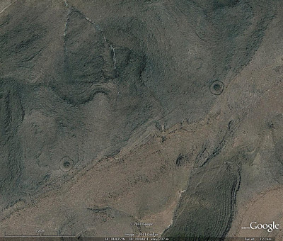
Having been distracted by Jordan and the wondrous Harrat ash-Sham, it is only recently that we returned to monitoring what high-resolution imagery had become available in Syria. A large section of imagery north east of Tadmur (Palmyra) has kept us busy with these stunning kites, as well as a few pendants and bullseye cairns.
Bullseye Cairns along a ridge, Syria.

A cluster of Kites, Syria.

Two Pendants along a ridge, Syria.

Wednesday 2 November 2011

Invisible kites

On our last flight, 20111027, we found something we never knew we had lost, a series of kites across the desert of Jordan that had almost been completely swallowed by the desert sands. These kites were not visible on satellite imagery available through Google Earth and Bing Maps which we use for a preliminary survey of the area before we fly. It was only through low level aerial reconnaisance that we were made aware of their presence. The state of preservation of these kites is so poor that they again disappeared when viewed at low oblique levels and would be completely invisible to anyone driving or walking past.
APAAME_20111027_REB-0360.
APAAME_20111027_REB-0362.


Friday 7 October 2011

Google: Archaeologist discovers 2,000 sites from thousands of miles away

Professor Kennedy projects Google Earth imagery on the high-resolution tiled display in the iVec Supercomputing Lab at UWA. Source: http://www.oneworldmanystories.com/new_sites.html
"It is readily apparent that the use of GE [Google Earth] for the prospection and identification of sites has great potential when dealing with a huge area that is otherwise largely inaccessible on the ground." – Professor David Kennedy, University of Western Australia

See the whole article at Google Earth's 'One World. Many Stories'.
See what else the world is achieving with GE at Search Stories.

Tuesday 27 September 2011

Let the flying begin

The long wait for our next flying season is almost over. David, Simon and myself have arrived in Jordan and have pitched base camp in the laboratory of the British Institute in Amman. We set out for Marka Air Force Base at 5:30am tomorrow morning (most archaeological sites appear at their best in raking morning light), and will fly over more than 100 targets in the north-west corner of Jordan, photographing many of them from the air for the first time.

The British Institute in Amman from above
APAAME_20100601_DDB-0575


David has sent me his list of target sites for this flight, some of which he has noted from academic articles and reports, and others that have been requested by researchers interested in specific aspects of Jordan's history. We are also revisiting several sites - including Jarash (ancient Gerasa) and Umm el Jimal ('The Mother of Camels' - a roman town) - that we have already photographed, to record new excavations and details the impact of continuing development that affects many sites in Jordan.

Route planning using Google Earth

All of these sites are put into an overall flight plan using MacGPS pro, and are then loaded into our two avionic GPS units, which allow us to navigate and direct the pilots to each site in turn. We generally fly in a circle over each site to allow us to photograph it from every angle. We aim to have the photographs up on our online archive as soon as possible (usually within a couple of days), so keep an eye out for these!

Simon Rutter tests out one of our Nikon D70s in preparation for the next morning's flight

Friday 19 August 2011

Comparing sites


Events of the recent past have not been kind to the archaeology of Iraq. Massive agricultural works and the expansion of modern cities (and, in some cases, large-scale illicit excavation) have altered many sites and landscapes beyond recognition. As we compare historical aerial photographs with recent satellite images, it's gratifying to find sites where the archaeology appears to have survived relatively unscathed. This is part of the incredible sprawling ruins of the Islamic period city north of Samarra, which seems to have changed little since it was photographed in 1918 by pilots of the Royal Air Force. This image and hundreds from the same time period are now housed in the National Archives, London.

Monday 15 August 2011

What a find!

Image: Google Earth

Today we came across a region of northern Syria while using Google Earth that is amazingly complex. Despite this area being currently used for agriculture, the numerous stone built structures and remnants of previous land use have survived the hoe. Here is a small window to give you a taste of this tantalising area! What can you see? (Click on the image to see a larger version)

Tuesday 9 August 2011

The Harret al-Shaam and aerial reconnaissance


Approximate extent of the Harret al-Shaam. Drawn by Mat Dalton.

The Harret al-Shaam is the most northerly of the basalt lavafields that mark the Arabian landscape from Syria in the north, down the western side of the Arabian Peninsula to Yemen in the South. The Harrat Ash-Sham, which itself stretches from Syria through Jordan and into Saudi Arabia, was first noted to contain remarkable stone structures visible from the air by the RAF pilots that flew across it on the airmail route from Cairo to Baghdad.

It is only recently that a more systematic aerial survey of the Harrat over Jordan has been started (Kennedy, D. L., Bewley, R. H., 2009. Aerial Archaeology in Jordan. Antiquity. 83, 69–81) but most countries in the greater Arabia area will not allow aerial reconnaissance or provide aerial imagery. Virtual globes such as Google Earth however provide accessible high resolution satellite imagery for sections of this expansive archaeological landscape which are being continually updated.

The original known distribution of the stone structures first captured in the lenses of RAF pilots, thought to be only located in the basalt lavafields of Jordan, has now been expanded dramatically. Google Earth has allowed for the number of Kites identified on the Harrat ash-Sham alone to increase dramatically - the most recent count (early 2011) was for c. 1600 Kites.
Distribution of the principle lava-fields. Drawn by Stafford Smith.

Bing Maps for Site Identification

After spending about 20 hours in the last week working with Bing Maps (i.e. their aerial/ satellite imagery) I can report that:
It is slow and difficult to work with compared to GE
It is mainly poor resolution of no value archaeologically
Where it is good it is often superb.
For parts of 'Arabia' where Bing is superor to GE I have identified over 100 new Kites (to take just the most obvious cateory)

-DLK

Thursday 4 August 2011

New beginnings, old material

This is what is going to be the blog of the many people working with APAAME: the Aerial Photographic Archive for Archaeology in the Middle East. We hope to take you with us as we conduct our field work in Jordan this year and keep you updated on our other research during the year. There are many interesting things we do when not in a helicopter flying over archaeological sites (we promise to try and leave out the not-so-interesting bits).

So, where to start? We have been looking at archaeological sites in Saudi Arabia recently using Google Earth. Our first case study conducted by David Kennedy and Mike Bishop on a high resolution area near Jeddah (published in the Journal of Archaeological Science) was picked up by the media who were amazed at the sheer number of new sites found. Well, we have moved on to another window, and we have found another site type.
This is a Segmented Trumpet near the town of Al-Hiyat. As you can see, it is laid out quite strikingly on a mud pan and can be seen quite clearly in the Google Earth image here. This has allowed us to trace it which will allow us to compare it to other similar sites that we may find. The ground photographs show that the site was built using basalt rocks from old lava flows, or Harrats, and though most of the walls are now rubble, some systematic building of walls can still be seen in sections.