Calibration of the Water Cloud Model at C-Band for Winter Crop Fields and Grasslands


"> Figure 1
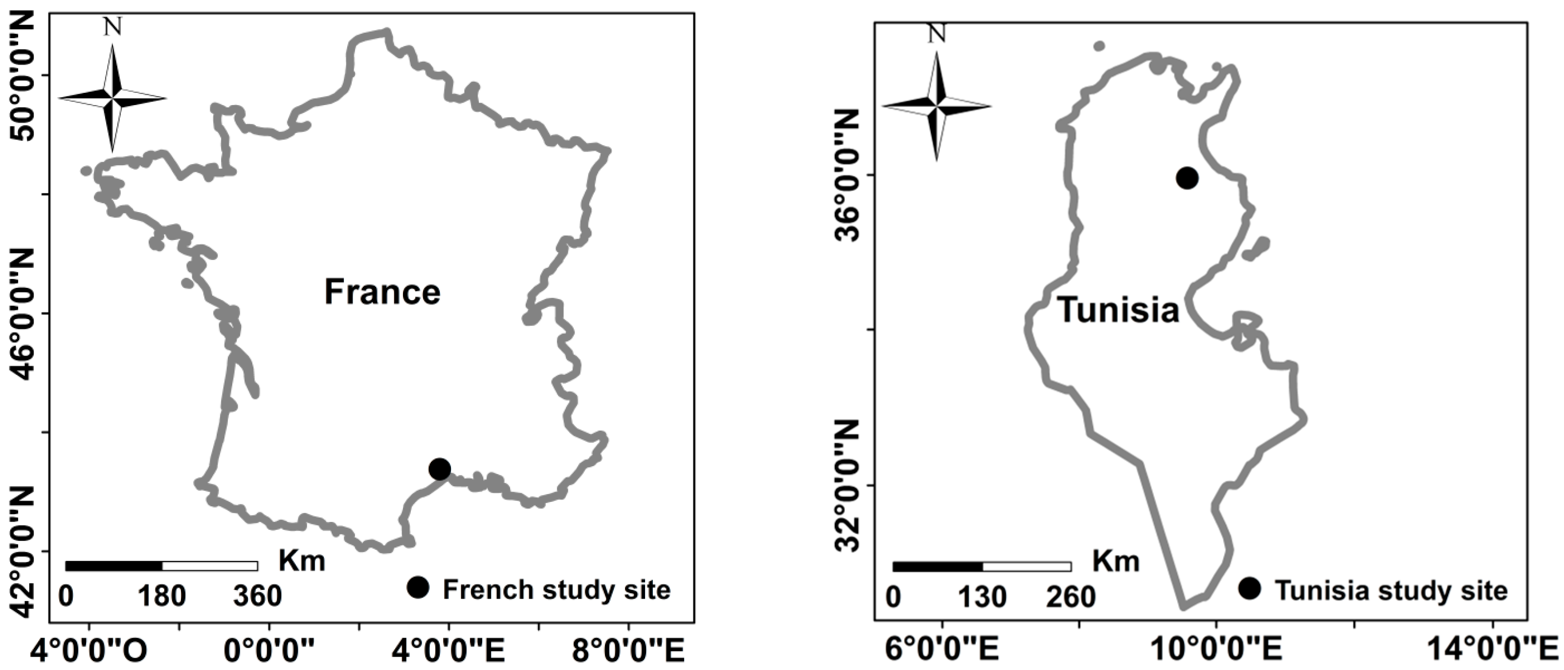
<p>Location of our two study sites.</p> "> Figure 2
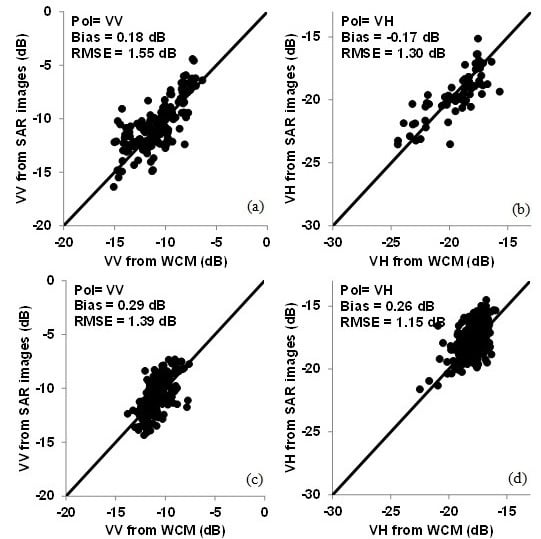
<p>Observed backscattering coefficients from SAR images vs. modeled backscatter values from WCM. Results of the training phase were given in (<b>a</b>,<b>b</b>). (<b>c</b>,<b>d</b>) correspond to validation phase. Mean of the difference between SAR and WCM and root mean square error were calculated.</p> "> Figure 3
<p>Behavior of WCM components (σ<sup>0</sup><sub>veg</sub>, T<sup>2</sup>σ<sup>0</sup><sub>soil</sub>, and σ<sup>0</sup><sub>tot</sub>) in VV polarization according to <span class="html-italic">mv</span> for 25° and 40° incidence angles. The soil roughness <span class="html-italic">Hrms</span> was fixed to 2 cm. (<b>a</b>): θ = 25° and NDVI = 0.3; (<b>b</b>): θ = 25° and NDVI = 0.6; (<b>c</b>): θ = 25° and NDVI = 0.8; (<b>d</b>): θ = 40° and NDVI = 0.3; (<b>e</b>): θ = 40° and NDVI = 0.6; (<b>f</b>): θ = 40° and NDVI = 0.8.</p> "> Figure 4
<p>Behavior of WCM components (σ<sup>0</sup><sub>veg</sub>, T<sup>2</sup>σ<sup>0</sup><sub>soil</sub>, and σ<sup>0</sup><sub>tot</sub>) in VH polarization according to <span class="html-italic">mv</span> for 25° and 40° incidence angles. The soil roughness <span class="html-italic">Hrms</span> was fixed to 2 cm. (<b>a</b>): θ = 25° and NDVI = 0.3; (<b>b</b>): θ = 25° and NDVI = 0.6; (<b>c</b>): θ = 25° and NDVI = 0.8; (<b>d</b>): θ = 40° and NDVI = 0.3; (<b>e</b>): θ = 40° and NDVI = 0.6; (<b>f</b>): θ = 40° and NDVI = 0.8.</p> "> Figure 5
<p>Behavior of WCM components (σ<sup>0</sup><sub>veg</sub>, T<sup>2</sup>σ<sup>0</sup><sub>soil</sub>, and σ<sup>0</sup><sub>tot</sub>) in VV and VH polarizations according to NDVI for 25° and 40° incidence angles, <span class="html-italic">mv</span> = 20 vol %, and <span class="html-italic">Hrms</span> = 2 cm. (<b>a</b>): VV and θ = 25°; (<b>b</b>): VV and θ = 40°; (<b>c</b>): VH and θ = 25°; (<b>d</b>): VH and θ = 40°.</p> ">
Abstract
:
1. Introduction
2. Dataset Description
2.1. Study Sites
2.2. Satellite Images
2.2.1. SAR Images
2.2.2. Optical Images
2.3. In Situ Measurements
3. Radar Signal Modeling
4. Results and Discussion
4.1. Water Cloud Model Parameterization
4.2. Water Cloud Model Validation
4.3. Behavior of Different Components of the WCM
5. Conclusions
Acknowledgments
Author Contributions
Conflicts of Interest
References
- Aubert, M.; Baghdadi, N.N.; Zribi, M.; Ose, K.; El Hajj, M.; Vaudour, E.; Gonzalez-Sosa, E. Toward an Operational Bare Soil Moisture Mapping Using TerraSAR-X Data Acquired Over Agricultural Areas. IEEE J. Sel. Top. Appl. Earth Obs. Remote Sens. 2013, 6, 900–916. [Google Scholar] [CrossRef] [Green Version]
- Baghdadi, N.; Camus, P.; Beaugendre, N.; Issa, O.M.; Zribi, M.; Desprats, J.F.; Rajot, J.L.; Abdallah, C.; Sannier, C. Estimating surface soil moisture from TerraSAR-X data over two small catchments in the Sahelian Part of Western Niger. Remote Sens. 2011, 3, 1266–1283. [Google Scholar] [CrossRef] [Green Version]
- Baghdadi, N.; Cresson, R.; El Hajj, M.; Ludwig, R.; La Jeunesse, I. Estimation of soil parameters over bare agriculture areas from C-band polarimetric SAR data using neural networks. Hydrol. Earth Syst. Sci. 2012, 16, 1607–1621. [Google Scholar] [CrossRef] [Green Version]
- El Hajj, M.; Baghdadi, N.; Zribi, M.; Belaud, G.; Cheviron, B.; Courault, D.; Charron, F. Soil moisture retrieval over irrigated grassland using X-band SAR data. Remote Sens. Environ. 2016, 176, 202–218. [Google Scholar] [CrossRef]
- Paloscia, S.; Pettinato, S.; Santi, E.; Notarnicola, C.; Pasolli, L.; Reppucci, A. Soil moisture mapping using Sentinel-1 images: Algorithm and preliminary validation. Remote Sens. Environ. 2013, 134, 234–248. [Google Scholar] [CrossRef]
- Zribi, M.; Chahbi, A.; Shabou, M.; Lili-Chabaane, Z.; Duchemin, B.; Baghdadi, N.; Amri, R.; Chehbouni, A. Soil surface moisture estimation over a semi-arid region using ENVISAT ASAR radar data for soil evaporation evaluation. Hydrol. Earth Syst. Sci. 2011, 15, 345–358. [Google Scholar] [CrossRef] [Green Version]
- Baghdadi, N.; Cresson, R.; Pottier, E.; Aubert, M.; Zribi, M.; Jacome, A.; Benabdallah, S. A potential use for the C-band polarimetric SAR parameters to characterize the soil surface over bare agriculture fields. IEEE Trans. Geosci. Remote Sens. 2012, 50, 3844–3858. [Google Scholar] [CrossRef] [Green Version]
- Baghdadi, N.; Aubert, M.; Zribi, M. Use of TerraSAR-X data to retrieve soil moisture over bare soil agricultural fields. IEEE Geosci. Remote Sens. Lett. 2012, 9, 512–516. [Google Scholar] [CrossRef] [Green Version]
- Zribi, M.; Saux-Picart, S.; André, C.; Descroix, L.; Ottle, C.; Kallel, A. Soil moisture mapping based on ASAR/ENVISAT radar data over a Sahelian region. Int. J. Remote Sens. 2007, 28, 3547–3565. [Google Scholar] [CrossRef]
- Fung, A.K.; Li, Z.; Chen, K.S. Backscattering from a randomly rough dielectric surface. IEEE Trans. Geosci. Remote Sens. 1992, 30, 356–369. [Google Scholar] [CrossRef]
- Baghdadi, N.; Choker, M.; Zribi, M.; Hajj, M.E.; Paloscia, S.; Verhoest, N.E.; Lievens, H.; Baup, F.; Mattia, F. A New Empirical Model for Radar Scattering from Bare Soil Surfaces. Remote Sens. 2016, 8, 920. [Google Scholar] [CrossRef]
- Dubois, P.C.; Van Zyl, J.; Engman, T. Measuring soil moisture with imaging radars. IEEE Trans. Geosci. Remote Sens. 1995, 33, 915–926. [Google Scholar] [CrossRef]
- Oh, Y. Quantitative retrieval of soil moisture content and surface roughness from multipolarized radar observations of bare soil surfaces. IEEE Trans. Geosci. Remote Sens. 2004, 42, 596–601. [Google Scholar] [CrossRef]
- Aubert, M.; Baghdadi, N.; Zribi, M.; Douaoui, A.; Loumagne, C.; Baup, F.; El Hajj, M.; Garrigues, S. Analysis of TerraSAR-X data sensitivity to bare soil moisture, roughness, composition and soil crust. Remote Sens. Environ. 2011, 115, 1801–1810. [Google Scholar] [CrossRef] [Green Version]
- Gorrab, A.; Zribi, M.; Baghdadi, N.; Mougenot, B.; Chabaane, Z.L. Potential of X-Band TerraSAR-X and COSMO-SkyMed SAR Data for the Assessment of Physical Soil Parameters. Remote Sens. 2015, 7, 747–766. [Google Scholar] [CrossRef] [Green Version]
- Fieuzal, R.; Duchemin, B.; Jarlan, L.; Zribi, M.; Baup, F.; Merlin, O.; Hagolle, O.; Garatuza-Payan, J. Combined use of optical and radar satellite data for the monitoring of irrigation and soil moisture of wheat crops. Hydrol. Earth Syst. Sci. 2011, 15, 1117–1129. [Google Scholar] [CrossRef]
- He, B.; Xing, M.; Bai, X. A Synergistic Methodology for Soil Moisture Estimation in an Alpine Prairie Using Radar and Optical Satellite Data. Remote Sens. 2014, 6, 10966–10985. [Google Scholar] [CrossRef]
- Hosseini, M.; Saradjian, M.R. Soil moisture estimation based on integration of optical and SAR images. Can. J. Remote Sens. 2011, 37, 112–121. [Google Scholar] [CrossRef]
- Notarnicola, C.; Angiulli, M.; Posa, F. Use of radar and optical remotely sensed data for soil moisture retrieval over vegetated areas. IEEE Trans. Geosci. Remote Sens. 2006, 44, 925–935. [Google Scholar] [CrossRef]
- Prakash, R.; Singh, D.; Pathak, N.P. A fusion approach to retrieve soil moisture with SAR and optical data. IEEE J. Sel. Top. Appl. Earth Obs. Remote Sens. 2012, 5, 196–206. [Google Scholar] [CrossRef]
- Anderson, M.C.; Neale, C.M.U.; Li, F.; Norman, J.M.; Kustas, W.P.; Jayanthi, H.; Chavez, J. Upscaling ground observations of vegetation water content, canopy height, and leaf area index during SMEX02 using aircraft and Landsat imagery. Remote Sens. Environ. 2004, 92, 447–464. [Google Scholar] [CrossRef]
- Courault, D.; Hadria, R.; Ruget, F.; Olioso, A.; Duchemin, B.; Hagolle, O.; Dedieu, G. Combined use of FORMOSAT-2 images with a crop model for biomass and water monitoring of permanent grassland in Mediterranean region. Hydrol. Earth Syst. Sci. Discuss. 2010, 7, 1731–1744. [Google Scholar] [CrossRef] [Green Version]
- El Hajj, M.; Baghdadi, N.; Belaud, G.; Zribi, M.; Cheviron, B.; Courault, D.; Hagolle, O.; Charron, F. Irrigated grassland monitoring using a time series of terraSAR-X and COSMO-skyMed X-Band SAR Data. Remote Sens. 2014, 6, 10002–10032. [Google Scholar] [CrossRef] [Green Version]
- Attema, E.P.W.; Ulaby, F.T. Vegetation modeled as a water cloud. Radio Sci. 1978, 13, 357–364. [Google Scholar] [CrossRef]
- De Roo, R.D.; Du, Y.; Ulaby, F.T.; Dobson, M.C. A semi-empirical backscattering model at L-band and C-band for a soybean canopy with soil moisture inversion. IEEE Trans. Geosci. Remote Sens. 2001, 39, 864–872. [Google Scholar] [CrossRef]
- Gherboudj, I.; Magagi, R.; Berg, A.A.; Toth, B. Soil moisture retrieval over agricultural fields from multi-polarized and multi-angular RADARSAT-2 SAR data. Remote Sens. Environ. 2011, 115, 33–43. [Google Scholar] [CrossRef]
- Prévot, L.; Champion, I.; Guyot, G. Estimating surface soil moisture and leaf area index of a wheat canopy using a dual-frequency (C and X bands) scatterometer. Remote Sens. Environ. 1993, 46, 331–339. [Google Scholar] [CrossRef]
- Sikdar, M.; Cumming, I. A modified empirical model for soil moisture estimation in vegetated areas using SAR data. In Proceedings of the 2004 IEEE International Geoscience and Remote Sensing Symposium, Anchorage, AK, USA, 20–24 September 2004; Volume 2, pp. 803–806. [Google Scholar]
- Champion, I.; Guyot, G. Generalized formulation for semi-empirical radar models representing crop backscattering. ESA Phys. Meas. Signat. Remote Sens. 1991, 1, 269–272. [Google Scholar]
- Baghdadi, N.; Holah, N.; Zribi, M. Calibration of the integral equation model for SAR data in C-band and HH and VV polarizations. Int. J. Remote Sens. 2006, 27, 805–816. [Google Scholar] [CrossRef]
- Baghdadi, N.; Chaaya, J.A.; Zribi, M. Semiempirical calibration of the integral equation model for SAR data in C-band and cross polarization using radar images and field measurements. IEEE Geosci. Remote Sens. Lett. 2011, 8, 14–18. [Google Scholar] [CrossRef]
- Schwerdt, M.; Schmidt, K.; Tous Ramon, N.; Klenk, P.; Yague-Martinez, N.; Prats-Iraola, P.; Zink, M.; Geudtner, D. Independent System Calibration of Sentinel-1B. Remote Sens. 2017, 9, 511. [Google Scholar] [CrossRef]
- El Hajj, M.; Baghdadi, N.; Zribi, M.; Angelliaume, S. Analysis of Sentinel-1 Radiometric Stability and Quality for Land Surface Applications. Remote Sens. 2016, 8, 406. [Google Scholar] [CrossRef] [Green Version]
- Balenzano, A.; Mattia, F.; Satalino, G.; Davidson, M. Dense temporal series of C-and L-band SAR data for soil moisture retrieval over agricultural crops. IEEE J. Sel. Top. Appl. Earth Obs. Remote Sens. 2011, 4, 439–450. [Google Scholar] [CrossRef]
- Brown, S.C.; Quegan, S.; Morrison, K.; Bennett, J.C.; Cookmartin, G. High-resolution measurements of scattering in wheat canopies-Implications for crop parameter retrieval. IEEE Trans. Geosci. Remote Sens. 2003, 41, 1602–1610. [Google Scholar] [CrossRef]
- Mattia, F.; Le Toan, T.; Picard, G.; Posa, F.I.; D’Alessio, A.; Notarnicola, C.; Gatti, A.M.; Rinaldi, M.; Satalino, G.; Pasquariello, G. Multitemporal C-band radar measurements on wheat fields. IEEE Trans. Geosci. Remote Sens. 2003, 41, 1551–1560. [Google Scholar] [CrossRef]


| Site | SAR Sensor | Optical Sensor | Year | Number of Data |
|---|---|---|---|---|
| Tunisian site: Training dataset | ASAR | Landsat | 2009, 2010, 2011, 2012 | VV: 92 measurements |
| Tunisian site: Training dataset | Sentinel-1 | Landsat | 2015, 2016, 2017 | VV: 68 measurements VH: 68 measurements |
| French site: Validation dataset | Sentinel-1 | Sentinel-2 | 2016, 2017 | VV: 261 measurements VH: 261 measurements |
| V1 = V2 = NDVI | ||||||
|---|---|---|---|---|---|---|
| Polarization | Apq | Bpq | R2pq | RMSEpq (dB) | Biaspq (dB) | N |
| pq = VV | 0.0950 | 0.5513 | 0.55 | 1.55 | 0.18 | 160 |
| pq = VH | 0.0413 | 1.1662 | 0.63 | 1.30 | −0.17 | 68 |
| VV (25°) | VV (40°) | |||||||
| mv (vol %) | 5 | 10 | 20 | 30 | 5 | 10 | 20 | 30 |
| NDVI | 0.70 | - | - | - | 0.51 | 0.65 | - | - |
| VH (25°) | VH (40°) | |||||||
| mv (vol %) | 5 | 10 | 20 | 30 | 5 | 10 | 20 | 30 |
| NDVI | 0.27 | 0.39 | 0.51 | 0.60 | 0.19 | 0.27 | 0.36 | 0.41 |
© 2017 by the authors. Licensee MDPI, Basel, Switzerland. This article is an open access article distributed under the terms and conditions of the Creative Commons Attribution (CC BY) license (http://creativecommons.org/licenses/by/4.0/).
Share and Cite
Baghdadi, N.; El Hajj, M.; Zribi, M.; Bousbih, S. Calibration of the Water Cloud Model at C-Band for Winter Crop Fields and Grasslands. Remote Sens. 2017, 9, 969. https://doi.org/10.3390/rs9090969
Baghdadi N, El Hajj M, Zribi M, Bousbih S. Calibration of the Water Cloud Model at C-Band for Winter Crop Fields and Grasslands. Remote Sensing. 2017; 9(9):969. https://doi.org/10.3390/rs9090969
Chicago/Turabian StyleBaghdadi, Nicolas, Mohammad El Hajj, Mehrez Zribi, and Safa Bousbih. 2017. "Calibration of the Water Cloud Model at C-Band for Winter Crop Fields and Grasslands" Remote Sensing 9, no. 9: 969. https://doi.org/10.3390/rs9090969