Tag: Flood·Alleviation
Showing latest 50 of 203 images tagged with Flood Alleviation tag.
|
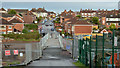
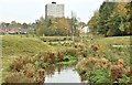
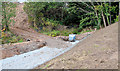
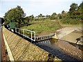
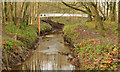
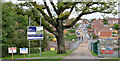
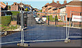
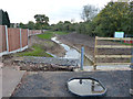
Flood alleviation works, Orangefield Park, Belfast (12)
by Albert Bridge geograph for square J3773 The view, across the new footbridge, towards Orangefield Lane. The Knock River... (more)
|
|
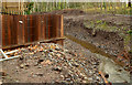
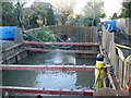
Flood alleviation works, Orangefield Park, Belfast (9)
by Albert Bridge geograph for square J3773 Work underway on the Knock River, a short distance upstream from the new... (more)
|
|
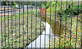
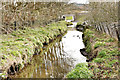
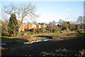
Flood alleviation works, Orangefield Park, Belfast (7)
by Albert Bridge geograph for square J3773 The present course of the Knock River, looking downstream at Orangefield... (more)
|
|
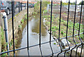
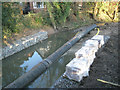
Flood alleviation works, Orangefield Park, Belfast (1)
by Albert Bridge for square J3773 The present course of the Knock River, looking upstream, at Orangefield... (more)
|
|
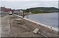
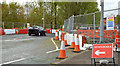
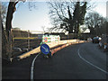
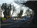
Flood defence works, by Kessock Road
by Craig Wallace geograph for square NH6546 A concrete wall is being constructed alongside the road. One lane of the road is... (more)
|
|
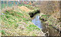
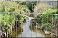
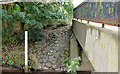
The Knock River, Belfast - August 2014(3)
by Albert Bridge for square J3673 The depth marker, immediately on the upstream side of the footbridge at the... (more)
|
|
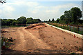
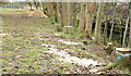
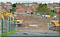
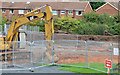
Flood alleviation works continue on a sunny day
by David Lally geograph for square SK5235 Nearly six months since SK5235 : Flood alleviation works continue on a bright cloudy day
|
|
Flood control system
by Mary and Angus Hogg geograph for square NS4937 Flood alleviation system near the River Irvine at Galston.
|
|
The Knock River, Belfast - November 2015(2)
by Albert Bridge geograph for square J3773 The Knock River, looking upstream from the bridge to Orangefield Lane, flowing... (more)
Tags:
place:BelfastX
Flood Alleviation
Knock River (Belfast)X
RiverX
subject:RiverX
top:Rivers, Streams, DrainageX
|
|
Knock River works, Belfast - February 2015(2)
by Albert Bridge geograph for square J3673 The Knock River (Conns Water on the Google map), looking upstream from this... (more)
|
|
Knock River works, Belfast - February 2015(1)
by Albert Bridge geograph for square J3673 The Knock River (Conns Water on the Google map), looking downstream from this... (more)
|
|
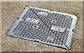
EJ "Scorpion" access cover, Belfast - January 2015(1)
by Albert Bridge for square J3673 An EJ (France)... (more)
|
|
Knock River works, Grand Parade, Belfast - September 2014(1)
by Albert Bridge geograph for square J3673 Relaignment of the Knock River, part of the overall Connswater flood alleviation... (more)
|
|
Chapelton Dam, on the Burn of Mosset
by Craig Wallace geograph for square NJ0457 Looking downstream from the top of the embankment dam, this is part of the Burn... (more)
|
|
Flood alleviation near Spine Road
by Christine Johnstone geograph for square SU0797 Floodwater had recently been pouring along this track parallel to the Thames and... (more)
|
|
The Lodge Burn, Coleraine
by Albert Bridge geograph for square C8532 The Lodge Burn, a short watercourse flowing through Coleraine into the Bann, is... (more)
|
|
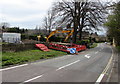
River works at Chester le Street
by Robert Graham geograph for square NZ2751 There has been a lot of flood alleviation work carried out here recently, on the... (more)
Tags:
top:City, Town CentreX
Flood Alleviation
Flood DefencesX
type:GeographX
top:Rivers, Streams, DrainageX
subject:StreamX
StreamX
|
|
The Knock River, Clara Park, Belfast (September 2015)
by Albert Bridge geograph for square J3773 The Knock River looking upstream from Clara Park. The flood alleviation works... (more)
Tags:
place:BelfastX
top:Construction, DevelopmentX
Flood Alleviation
Knock River (Belfast)X
RiverX
subject:RiverX
top:Rivers, Streams, DrainageX
|
|
Knock River works, Belfast - February 2015(3)
by Albert Bridge geograph for square J3673 The green space, between Dunraven Gardens and the northern side of the Knock... (more)
|
|
The Knock River, Orangefield Park, Belfast - November 2014(3)
by Albert Bridge geograph for square J3773 The Knock River, flowing from left to right, at this footbridge J3773 : Footbridge, Orangefield Park, Belfast (July 2014).... (more)
|
|
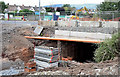
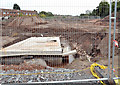
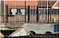
Grand Parade culvert improvements, Belfast - September 2014(3)
by Albert Bridge geograph for square J3673 Widening of the Knock River culvert, under Grand Parade, seen from Grand Parade.... (more)
|
|
Grand Parade culvert improvements, Belfast - September 2014(1)
by Albert Bridge geograph for square J3673 Widening of the Knock River culvert, under Grand Parade, seen from Orangefield... (more)
|
|
Roadworks, Grand Parade, Belfast (April 2014)
by Albert Bridge geograph for square J3673 Work underway, widening this culvert J3673 : Culvert, Knock River, Belfast, at Grand Parade, as part of... (more)
Tags:
place:BelfastX
subject:ConstructionX
top:Construction, DevelopmentX
CulvertX
Flood Alleviation
Knock River (Belfast)X
RiverX
top:Roads, Road TransportX
RoadworksX
|
|
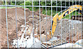
Flood alleviation works, Orangefield Park, Belfast (11)
by Albert Bridge for square J3773 Sheet piling, behind Orangefield Park, close to here J3773 : Flood alleviation works, Orangefield Park, Belfast (9).
|
|
Flood alleviation works, Orangefield Park, Belfast (10)
by Albert Bridge geograph for square J3773 See J3773 : Flood alleviation works, Orangefield Park, Belfast (9). The view in the other direction (downstream) towards the new... (more)
|
|
Flood alleviation works, Orangefield Park, Belfast (8)
by Albert Bridge geograph for square J3773 Work underway in constructing the new course for the Knock River, from the path... (more)
|
|
Flood alleviation works, Orangefield Park, Belfast (6)
by Albert Bridge geograph for square J3773 Work underway in constructing the new course for the Knock River, from the path... (more)
|
|
Flood alleviation works, Orangefield Park, Belfast (5)
by Albert Bridge geograph for square J3773 Work underway in constructing the new course for the Knock River, from the path... (more)
|
|
Flood alleviation works, Orangefield Park, Belfast (4)
by Albert Bridge geograph for square J3773 A view of the works looking towards Orangefield Lane (background middle/right).
|
|
Flood alleviation works, Orangefield Park, Belfast (3)
by Albert Bridge geograph for square J3773 Work underway in constructing the new course for the Knock River. This view is... (more)
|
|
Flood alleviation works, Orangefield Park, Belfast (2)
by Albert Bridge geograph for square J3773 Work underway in constructing the new course for the Knock River. This view is... (more)
|
|
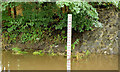
Depth marker, Knock River, Belfast
by Albert Bridge geograph for square J3673 A depth marker beside the Knock River and this footbridge J3673 : Footbridge, Belfast. The... (more)
|
|
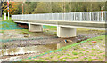
New bridge, Orangefield Lane, Belfast (2)
by Albert Bridge geograph for square J3773 The new bridge, across the Knock River J3773 : The Knock River, Belfast (10), at Orangefield Lane part... (more)
|
|
New bridge, Orangefield Lane, Belfast (1)
by Albert Bridge for square J3773 The new bridge, across the Knock River J3773 : The Knock River, Belfast (10), at Orangefield Lane part... (more)
|
|
L Lynch excavator at the edge of High Street, Broadway
by Jaggery geograph for square SP1037 Viewed on May 1st 2016. A nearby temporary sign shows
Flood alleviation work on... (more)
|
|
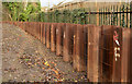
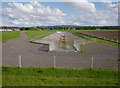
Pilmuir drainage channel
by Craig Wallace geograph for square NJ0258 Part of the Forres flood alleviation scheme. This open channel can carry water... (more)
Tags:
Drainage ChannelX
Flood Alleviation
place:ForresX
type:GeographX
Pumping StationX
top:Suburb, Urban FringeX
top:Water ResourcesX
|
|
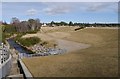
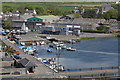
Inner harbour at Castletown
by Richard Hoare geograph for square SC2667 Work is about to commence on the flood alleviation scheme, hence the... (more)
Tags:
Castle RushenX
top:Construction, DevelopmentX
top:Docks, HarboursX
Flood Alleviation
type:GeographX
subject:HarbourX
top:Historic Sites and ArtefactsX
top:Rivers, Streams, DrainageX
|
|
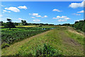
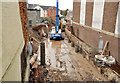
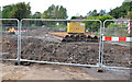
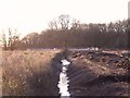
Drainage improvements on Sinfin Moor
by Ian Calderwood geograph for square SK3631 The drains on Sinfin Moor are being improved as part of flood alleviation work,... (more)
Tags:
Construction SiteX
top:Construction, DevelopmentX
subject:DrainageX
former:FarmlandX
Flood Alleviation
name:Infinity ParkX
top:Rivers, Streams, DrainageX
top:Suburb, Urban FringeX
|
|
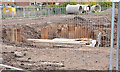
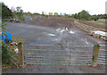
Construction site compound along Watergate Lane
by Mat Fascione geograph for square SK5501 Lubbesthorpe Brook Flood Alleviation Scheme.
Construction work has been on... (more)
|
|
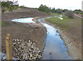
Lubbesthorpe Brook Flood Alleviation Scheme
by Mat Fascione geograph for square SK5501 Construction work has been on going for months, whilst the widening and... (more)
|
|
Lubbesthorpe Brook Flood Alleviation Scheme
by Mat Fascione geograph for square SK5501 Construction work has been on going for months, whilst the widening and... (more)
|
|
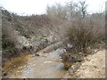
Fisher's Brook flood alleviation, temporary bank restraint
by Robin Stott geograph for square SP2763 Looking northwest. Further upstream it's called Gog Brook SP2763 : Gog Brook.
|
|
Fisher's Brook flood alleviation works southwest of Lodge Crescent
by Robin Stott geograph for square SP2763 Compare with SP2763 : Fisher's Brook near Leafield Farm, Warwick. The height of the right-hand bank has been reduced.
|
|
Flood alleviation work in progress below Fisher's Bridge
by Robin Stott geograph for square SP2763 The brook in a pipe is carried clear while other works are implemented at the... (more)
Tags:
top:Construction, DevelopmentX
Flood Alleviation
top:LowlandsX
Postcode Area CV34X
Residential AreaX
top:Rivers, Streams, DrainageX
road:Stratford RoadX
top:Suburb, Urban FringeX
place:WarwickX
|
|
Fisher's Bridge, traffic barrier and temporary parapet
by Robin Stott geograph for square SP2763 Single-file traffic operated over the bridge while contractors constructed a new... (more)
Tags:
top:Construction, DevelopmentX
Flood Alleviation
top:LowlandsX
Postcode Area CV34X
Residential AreaX
top:Rivers, Streams, DrainageX
road:Stratford RoadX
top:Suburb, Urban FringeX
place:WarwickX
|
|
Single-file traffic over Fisher's Bridge, Stratford Road
by Robin Stott geograph for square SP2763 Contractors for the Environment Agency are constructing a new culvert under... (more)
Tags:
top:Construction, DevelopmentX
Flood Alleviation
top:LowlandsX
Postcode Area CV34X
top:Rivers, Streams, DrainageX
road:Stratford RoadX
top:Suburb, Urban FringeX
place:WarwickX
|
|
The Ballynahinch River near Crossgar
by Albert Bridge geograph for square J4152 The Ballynahinch River, immediately downstream from Lyons Bridge. The river,... (more)
|
|
The Lodge Burn, Coleraine (2)
by Albert Bridge for square C8532 See C8532 : The Lodge Burn, Coleraine (January 2012). A similar view, from the Railway Road, where... (more)
|
|
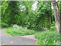
Lakes lie this way - Red House Park, Great Barr, Sandwell
by Martin Richard Phelan geograph for square SP0394 Take this path off to the right to reach the two lakes which lie at the lowest... (more)
Tags:
Flood Alleviation
type:GeographX
place:Great BarrX
LakesX
top:LowlandsX
M5 & M6 MotorwaysX
top:Park and Public GardensX
subject:Path JunctionX
top:PathsX
place:Red House ParkX
top:Sport, LeisureX
top:Suburb, Urban FringeX
West MidlandsX
|
|
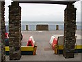
Flood prevention measures
by Ian Paterson geograph for square SC3875 In winter time, boards are placed along the edge of the prom to keep the worst... (more)
|