TA1028 : Victoria Pier, Kingston upon Hull
taken 10 years ago, near to Kingston Upon Hull, England
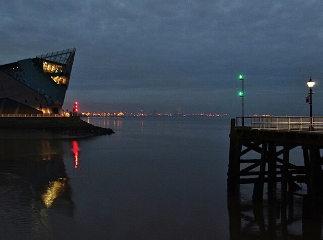
Corporation Pier, constructed in 1810, was parallel to the mainland but not directly connected to it. It was converted to a T-shaped pier in 1847. It was the terminus of the Hull to New Holland ferry, initially run by the Manchester Sheffield & Lincolnshire Railway and later by the LNER and British Rail, until the service ended in 1981 due to the opening of the Humber Bridge. It was renamed Victoria Pier in 1854 in honour of Queen Victoria consequential of her visit to the town. A railway booking office, latterly named Hull Victoria Pier, was established here circa 1849 by the MS&LR, and closed on 25 June 1981 with the cessation of the ferry service. The pier has been altered several times. A floating pontoon was added in 1877 and removed in 1980; an upper Promenade was added in 1882, and removed in the mid-20th century. Wikipedia: Link
The Humber Estuary or River Humber is a large tidal estuary on the east coast of Northern England. It is formed at Trent Falls by the confluence of the tidal rivers Ouse and Trent. From there to the North Sea, it forms part of the boundary between the East Riding of Yorkshire on the north bank and North Lincolnshire on the south bank.
Further information:
Wikipedia: Link
Humber Nature Partnership: Link
European Union: Link
The Deep, a public aquarium, built 2000-01, designed by Sir Terry Farrell, opened to the public March 2002. Voted best family attraction in Kingston upon Hull in 2013.
Further reading:
The Deep: Link
Wikipedia: Link
Visit Hull: Link
- Grid Square
- TA1028, 3623 images (more nearby 🔍)
- Photographer
- Bernard Sharp (more nearby)
- Date Taken
- Tuesday, 25 November, 2014 (more nearby)
- Submitted
- Friday, 7 March, 2025
- Subject Location
-
OSGB36:
 TA 1009 2812 [10m precision]
WGS84: 53:44.2712N 0:19.9460W - Camera Location
-
OSGB36: TA 1000 2812
- View Direction
- EAST (about 90 degrees)