TA0928 : Savile Street, Kingston upon Hull
taken 8 days ago, near to Kingston Upon Hull, England
The very first street in Wyke upon Hull was Westgate, subsequently named Beverley Street (the semi-continuous modern-day Sewer Lane, Fish Street, King Street, Trinity House Lane, Land of Green Ginger, and Winter's Alley that exits at No. 7 Parliament Street). This winding street most probably followed the route of a watercourse, probably Wycotedyke, that flowed into the Humber. By 1293, the newly-named Kingston upon Hull included Hull Street (nowadays called High Street, but originally named after the river whose banks it closely followed), Marketgate (Market Place) and Munkgate (Blackfriargate and Blanket Row). By 1347 all the other streets within the medieval town had appeared.
Street nameplates are known from as early as 1636 in London, but the oldest in Kingston upon Hull is most probably that affixed to Trinity House, bearing the legend T.W. POSTERN GATE: Link
LAND OF GREEN GINGER is probably the most unusual street and famous name in the city: Link
Much design advice has been issued over the years, but a national style has never been adopted, such that each local authority has determined its own. Consequently, many different styles, fonts, sizes, colours and materials are to be found, even within the same authority. Some types of plate have proved to be more durable than others.
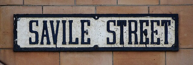
CAST METAL PLATES OF C19: The oldest style of nameplates have typeface with serifs, either embossed or debossed, painted black on a white (exceptionally, blue) background. Framed, with chamfered corners. Found entirely on the older buildings in central Kingston upon Hull. Example: Link
TILED NAMEPLATES: These consist of an individual, manufactured tile for each letter. They were introduced circa 1844, are abundant in the older parts of the city, and have proved to be very durable. It is possible that they were manufactured by Minton Tiles, whose catalogue reproduces similar tiles in Series 2917. Tiles used are chiefly letters with serifs, overwhelmingly white on a black background, with just a few on a blue background, 'Series 2919', and mainly composed in a single row. Example: Link It would appear to be the practice that tiled nameplates for 'ten-foots' (avenues, groves and similar) were to be in sans-serif typeface, but the reason for this is unknown. Several cases have been seen where the letters are of varying heights. Example: Link In Kingston upon Hull, it would appear that tiled nameplates were phased out in the 1920s in favour of cast metal plates, where the taller characters rendered the plates more legible. Further information: 'London Street Signs' by Alistair Hall, 2020, pp. 55 69, and Herbert Minton Tiles in Devon: Link
CAST METAL PLATES OF C20: This type superseded the tiled plates in Kingston upon Hull in the 1920s. With taller characters and in black on a white background, they were more legible than hitherto. The drawback is that the plates needed to be repainted as the lettering faded or the paintwork flaked. Initially, plates were made with chamfered corners, subsequently merely rounded. Example: Link
MINISTRY OF TRANSPORT ALPHABETS: Standard and Compressed alphabets introduced simultaneously early 1930s. Compressed was used the most being the cheaper option. A Revised alphabet of 1952 modified the two earlier alphabets. The MOT additionally recommended Kindersley (see below), Gill Sans and Caslon Old Face: Link
KINDERSLEY ALPHABET: Named after its creator, David Kindersley, and adopted by the Ministry of Transport in 1951. Example: Link
'HULL OLD TOWN' PLATES: Introduced circa 2013. Incorporate Three Crowns logo of the city together with 'Hull Old Town'. Kindersley typeface, white on a blue background. Example: Link Probably about the same time, all the existing cast metal nameplates in the Old Town were repainted with a blue background.
ALPHABETS IN 2020: Recommended in current legislation: MOT Revised: LinkKindersley: Link
Further reading: Streets of Hull A History of their Names, by John Markham, 1987, 62 pp
Whats in a (street) name? Link
and from other places: London Street Signs: Link
In 1773, the Hull Corporation, Hull Trinity House and Hull merchants formed the Hull Dock Company, the first statutory dock company in Britain. The town's first dock was built on land formerly occupied by the redundant town walls. This was The Dock, built 1775-78, known as The Old Dock from 1809, and renamed Queen's Dock in 1855 after the Queens visit to the town in 1854. The dock entrance was on the River Hull just south of the old North Bridge: Link
- Grid Square
- TA0928, 6874 images (more nearby 🔍)
- Photographer
- Bernard Sharp (more nearby)
- Date Taken
- Tuesday, 4 March, 2025 (more nearby)
- Submitted
- Wednesday, 5 March, 2025
- Subject Location
-
OSGB36:
 TA 0964 2879 [10m precision]
WGS84: 53:44.6380N 0:20.3409W - Camera Location
-
OSGB36: TA 0963 2879
- View Direction
- EAST (about 90 degrees)