SX4854 : Plymouth Library, Art Gallery & Museum
taken 9 years ago, near to Plymouth, England
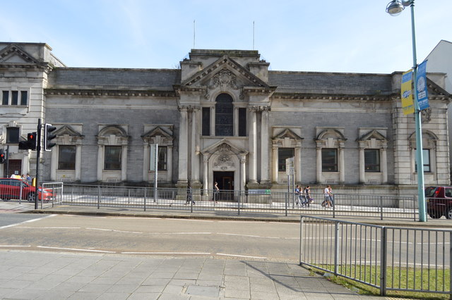
Plymouth City Museum and Art Gallery in the Drake Circus area of Plymouth, is the largest museum and art gallery in the city. It was built in 190710 by Thornely and Rooke in Edwardian Baroque style.
The Museum has collections of fine and decorative arts, natural history and human history. The museum's natural history collection consists of over 150,000 specimens and an historic natural history library and archive. Many prehistoric artefacts from Dartmoor, important Bronze Age and Iron Age material from Mount Batten and medieval and post-medieval finds from Plymouth are found in the human history collection alongside artifacts from ancient Egypt and other ancient cultures of Europe and the Middle East.
The Art Gallery collections include 750 easel paintings, over 3,000 watercolours and drawings, at least 5,000 prints and a sizeable collection of sculptures. A large proportion of the art was donated to the people of Plymouth in 1852 by William Cotton (17941863) and is known as the Cottonian Collection. It had been put together principally by the collector Charles Rogers (17111784), and includes works by Sir Joshua Reynolds who was born locally.
Grade II listed. Link
Closed in 2017 and converted into The Box a £37 million gallery and museum complex that will house seven collections in one building and is destined to become a key cultural attraction for the city and the region.
The Box (previously known as the Plymouth History Centre) will open as the flagship building for the Mayflower 400 commemorations in spring 2020.
A striking contemporary extension on the back of the former Museum and Art Gallery and Central Library is being built and St. Lukes Church transformed.
The buildings will be linked by an outdoor public space with food, drink and retail outlets.
Listed buildings and structures are officially designated as being of special architectural, historical or cultural significance. There are over half a million listed structures in the United Kingdom, covered by around 375,000 listings.
Listed status is more commonly associated with buildings or groups of buildings, however it can cover many other structures, including bridges, headstones, steps, ponds, monuments, walls, phone boxes, wrecks, parks, and heritage sites, and in more recent times a road crossing (Abbey Road) and graffiti art (Banksy 'Spy-booth') have been included.
In England and Wales there are three main listing designations;
Grade I (2.5%) - exceptional interest, sometimes considered to be internationally important.
Grade II* (5.5%) - particularly important buildings of more than special interest.
Grade II (92%) - nationally important and of special interest.
There are also locally listed structures (at the discretion of local authorities) using A, B and C designations.
In Scotland three classifications are also used but the criteria are different. There are around 47,500 Listed buildings.
Category A (8%)- generally equivalent to Grade I and II* in England and Wales
Category B (51%)- this appears generally to cover the ground of Grade II, recognising national importance.
Category C (41%)- buildings of local importance, probably with some overlap with English Grade II.
In Northern Ireland the criteria are similar to Scotland, but the classifications are:
Grade A (2.3%)
Grade B+ (4.7%)
Grade B (93%)
Read more at Wikipedia Link
- Grid Square
- SX4854, 2278 images (more nearby 🔍)
- Photographer
- N Chadwick (more nearby)
- Date Taken
- Saturday, 19 September, 2015 (more nearby)
- Submitted
- Friday, 29 January, 2016
- Subject Location
-
OSGB36:
 SX 4807 5488 [10m precision]
WGS84: 50:22.4488N 4:8.2770W - Camera Location
-
OSGB36: SX 4805 5491
- View Direction
- Southeast (about 135 degrees)