TA0928 : Prince's Dock Street, Kingston upon Hull
taken 11 years ago, near to Kingston Upon Hull, England
Hull Trinity House, established in 1369, is a seafaring organisation consisting of a charity for seafarers, a school, and a guild of mariners. The guild originated as a religious guild providing support and almshouses for the needy and established a school for mariners in 1787. By the 18th century it had responsibilities including management of the harbour at Hull, and buoys and pilotage in the Humber Estuary. After the loss of many of its responsibilities as a result of the Humber Conservancy Act 1852, the guild continued its work as a charity, and the provision of education, which continues to the present day: Link
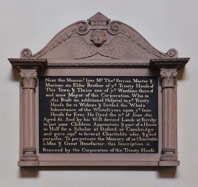
Trinity House and adjoining offices and houses cover the site of the White Friars (Carmelites), dissolved in 1539, and given to the institution by Thomas Ferres in 1621. The premises face onto Trinity House Lane, Posterngate and Prince's Dock Street. The Trinity House Building was rebuilt in 1753, and a guild house added in 1775. Grade I Listed Building LinkStatues of Neptune and Britannia were installed above the main entrance, with the building forming a square around a courtyard, with almshouse rooms around it.
Trinity House Chapel, built 1842 in the Classical Revival style, replaced the chapel of 1772. Grade II Listed Building: Link
Hull Trinity House almshouses, Posterngate, built 1826 by Charles Mountain the Younger. Converted to offices 1956-57. Carmelite House is named after the Carmelites or White Friars, who held land between Posterngate and Whitefriargate until the dissolution of their monastery in the town. Grade II Listed Building Link
The buoy shed was built 1901 for the Trinity House in Tower Street. It has latterly been occupied by Northern Divers, now vacant for several years. Grade II Listed Building Link
Further information in Wikipedia: Link
In 1785 a marine school was founded on the property of the Trinity House. A new building was constructed on the Trinity House site, adjacent to the chapel and the school opened in 1787. Students were taught reading, writing, accountancy, religion, and navigation for three years after which they were apprenticed. The school moved to a new building in Princes Dock Street in 1842. By the second half of the 20th century the school (Trinity House Navigation School) had become an independent secondary technical school. The school gained specialist status in 2008 and became Hull Trinity House Academy in 2012. In 2013 the school moved to a new site on George Street, using a refurbished former university building. The site of the old school was redeveloped as a car park/events area called Zebedee's Yard in 2014. The academy moved to the former Endeavour Academy site on Beverley Road in 2023.
The Gatehouse to Trinity House Navigation School was built in the Classical Revival style, 1842. Grade II Listed Building Link
Further information in Wikipedia: Link
- Grid Square
- TA0928, 6875 images (more nearby 🔍)
- Photographer
- Bernard Sharp (more nearby)
- Date Taken
- Saturday, 14 September, 2013 (more nearby)
- Submitted
- Sunday, 15 September, 2013
- Subject Location
-
OSGB36:
 TA 0982 2863 [10m precision]
WGS84: 53:44.5495N 0:20.1806W - Camera Location
-
OSGB36: TA 0982 2863
- View Direction
- NORTH (about 0 degrees)