2011
TQ3281 : Barbican, Silk Street (1)
taken 14 years ago, near to City of London, The City of London, England
This is 1 of 6 images, with title starting with Barbican, Silk Street in this square
Barbican, Silk Street (1)
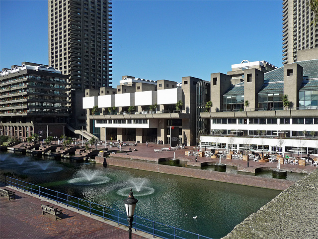
The arts centre and Guildhall School of Music ahead, Shakespeare Tower on the left, and a bit of Cromwell Tower on the right. When built the residential towers were Europe's highest. Grade II listed.
"There is nothing quite like the Barbican Estate in all British architecture", wrote Pevsner. This is attributed to its sheer scale, magnified by the use of concrete, and its segregation of traffic and pedestrians by means of elevated walkways. The estate was the second stage in the Corporation of London's plan to reverse its depopulation as a result of the war (it was built on land ravaged by bombing). The architects chosen were Chamberlin, Powell & Bon, fresh from the City's Golden Lane Estate, work commenced in 1963 and was not completed until 1981. A total of 2,100 flats were built over the 35-acre site, which also includes a school and arts centre. All in all it is an impressive scheme, but the sheer amount of concrete on display renders it less immediately likeable than, say, a Georgian terrace! Sun and blue sky certainly help. Its salubrity, however, gives the lie to the specious idea that large concrete housing estates are intrinsically crime-ridden. That might just have more to do with social issues than the choice of architectural style or building material. It is now listed, quite a feat for so much Brutalism.
"There is nothing quite like the Barbican Estate in all British architecture", wrote Pevsner. This is attributed to its sheer scale, magnified by the use of concrete, and its segregation of traffic and pedestrians by means of elevated walkways. The estate was the second stage in the Corporation of London's plan to reverse its depopulation as a result of the war (it was built on land ravaged by bombing). The architects chosen were Chamberlin, Powell & Bon, fresh from the City's Golden Lane Estate, work commenced in 1963 and was not completed until 1981. A total of 2,100 flats were built over the 35-acre site, which also includes a school and arts centre. All in all it is an impressive scheme, but the sheer amount of concrete on display renders it less immediately likeable than, say, a Georgian terrace! Sun and blue sky certainly help. Its salubrity, however, gives the lie to the specious idea that large concrete housing estates are intrinsically crime-ridden. That might just have more to do with social issues than the choice of architectural style or building material. It is now listed, quite a feat for so much Brutalism.
TIP: Click the map for more Large scale mapping
- Grid Square
- TQ3281, 5942 images (more nearby 🔍)
- Photographer
- Stephen Richards (more nearby)
- Date Taken
- Saturday, 19 March, 2011 (more nearby)
- Submitted
- Sunday, 4 September, 2011
- Subject Location
-
OSGB36:
 TQ 3234 8178 [10m precision]
WGS84: 51:31.1667N 0:5.6395W - Camera Location
-
OSGB36: TQ 3239 8172
- View Direction
- Northwest (about 315 degrees)