near to Pinchbeck, Lincolnshire, England
Coverage
We have
46 images
in grid square TF2424
Maps
TIP: Click the map for more Large scale mapping
Tip: Click the map to open the coverage map
Sample images
Breakdown list
images taken from TF2424 [1]
A sample of 12 photos from 46
for TF2424
- View this square in the Browser >>>

|
Vernatts Drain
by Donnylad
Drainage Channel to the north of Spalding, named in honour of one of the engineers who devised the draining of the fens. This view is looking west from the road bridge on the B1356.
|

|
Baxter Gardens, Spalding
by Kate Jewell
Off Lilburn Drive
|

|
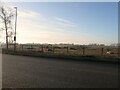
Wardentree Lane towards Pinchbeck
by Mat Fascione
|
|
Housing development (set of 2 images) |

|
Old Milestone, B1356, Pinchbeck Road, Spalding
The milestone is located in the pavement between Nos. 128 and 130, opposite Fern Drive, on the east side of the road. Parish of Spalding (South Holland District). Carved stone post, erected by Spalding & Donington turnpike trust in the... (more)
|

|
Yew Tree Farm
by Bob Harvey
Dating from the end of the Georgian era this dignified farmhouse is part of a grade II listed set of buildings here Link
|

|
New housing, Atherton Gardens |

|
New roundabout |

|
On Sharp's Bridge, Pinchbeck Road, Spalding |

|
Spalding 1
by Keith Evans
Old milestone at Spalding, Lincolnshire for overall view see Link
|

|
Vernatt's Drain
by JThomas
|

|
Daniel's Reach, Spalding
by Kate Jewell
Off Lilburn Drive and leading to Miles Bank, with direct access to the footpath along Vernatt's Drain.
|
Explore more images in this square: | View Filtering options | View all 46 images page by page >>> |
|