near to Upton, Slough, England
Coverage
We have
85 images
in grid square SU9679
Maps
TIP: Click the map for more Large scale mapping
Tip: Click the map to open the coverage map
Sample images
Breakdown list
images taken from SU9679 [1]
A sample of 12 photos from 85
for SU9679
- View this square in the Browser >>>
|
Chalvey Sports and Social Club |
|
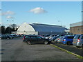
Slough Ice Arena
Just showing on the right in this 2014 view is the Montem Leisure Centre, now demolished.
|
|
Roadworks on the A355
Roadworks on the A355 at the junction 6 of the M4.
|
|
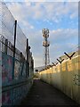
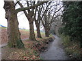
Footpath through Chalvey |
|
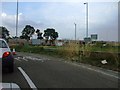
Roundabout for the M4, Chalvey
by David Howard
Straight ahead for Windsor
|
|
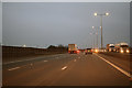
Slough : M4 Motorway
by Lewis Clarke
The M4 Motorway between Junction 6 (Tuns Lane) and Junction 5 (Langley Roundabout).
|
|
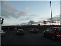
Montem Leisure Centre
A rear view from the car park.
|
|
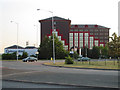
Copthorne Hotel Slough
by Darren Smith
This imposing building can be seen for miles around, especially from the M4 and the road from Windsor. This photo is taken looking SW from the A355.
|
|
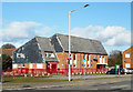
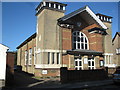
Methodist Church
by don cload
|
|
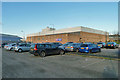
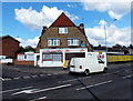
Tyre Station, Slough
by Jaggery
Located on the corner of Seymour Road at 7880 Church Street, Chalvey, Slough. In addition to selling tyres, repairing punctures and wheel balancing, the business has a car wash service.
|
|
Salt Hill Stream in Montem Recreation Ground in Slough
by Nigel Cox
All the old Ordnance Survey 6" to the mile maps from 1900 through to 1938 show the stream in use in this area for watercress beds, fed by three springs on the bank to the left.
|
|
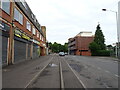
Chalvey Road West, Slough
by JThomas
|
Explore more images in this square: | View Filtering options | View all 85 images page by page >>> |
|