near to Beverston, Gloucestershire, England
Coverage
We have
17 images
in grid square ST8694
Maps
TIP: Click the map for more Large scale mapping
Tip: Click the map to open the coverage map
Sample images
Breakdown list
taken pre 2000 [1]
A sample of 12 photos from 17
for ST8694
- View this square in the Browser >>>
|
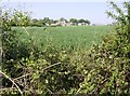
Towards Beverston Castle
by Graham Horn
From the bridleway at the eastern side of the square, looking west towards Beverston Castle. The farm buildings can be seen with the church just above. The cereal crop in this fields seems particularly well advanced for 1st May.
|

|
The route of Chavenage Lane
by don cload
|

|
Ordnance Survey Cut Mark
by Adrian Dust
This OS cut mark can be found on the south face of St Mary's Church. It marks a point 158.614m above mean sea level.
|

|
Stone Stile, Chavenage/Beverston
A "Fallen Idle" on Gloucestershire footpath NBE3 between Chavenage and Beverston, close to the bridleway NBE1.
Broad Newell Covert lies to the SW.
|

|
Beverston church
The church is dedicated to St Mary the Virgin and is situated near Beverston Castle.
|

|
Beverston, St. Mary's Church: The Saxon Resurrection sculpture |

|
Towards Chavenage
by Graham Horn
Looking north from the top of a rise on the bridleway running along the eastern side of the square. The bridleway route continues in the line of trees rising the other side of the small valley, and leads past Chavenage House (in the top... (more)
|

|
St Mary, Beverston
by John Salmon
|

|
Beverstone Church (also spelt Beverston)
by Roger May
A view of the church enhanced by the dappling sunlight
|

|
St Mary's church, Beverston
Small parish church largely of the thirteenth and fourteenth centuries though on older foundations Link
|

|
Beverston Church from the north
by Ruth Riddle
The view from the north-eastern corner of the churchyard.
|

|
St Mary, Beverston - Exterior carving
by John Salmon
|
Explore more images in this square: | View Filtering options | View all 17 images page by page >>> |
|