near to Caerleon, Newport/Casnewydd, Wales
Coverage
We have
352 images
in grid square ST3289
Maps
TIP: Click the map for more Large scale mapping
Tip: Click the map to open the coverage map
Sample images
Breakdown list
images taken from ST3289 [8]
A sample of 12 photos from 352
for ST3289
- View this square in the Browser >>>

|
Caerleon Road, Newport
by David Howard
The Car Link is on the left, using an old petrol station.
|
|
Ordnance Survey Cut Mark
by Adrian Dust
This OS cut mark can be found on No35 St Julians Road. It marks a point 33.403m above mean sea level.
|
|
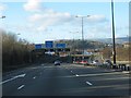
M4 junction 25
by John Thorn
Twmbarlwm Hill Fort on the skyline above the Cardiff sign. [Looking NW]
|

|
Down Ennerdale Court, Old Barn Estate, Newport
by Jaggery
Ennerdale Court descends past the Buttermere Way junction towards the Coniston Close junction.
|

|
The road to Cwmbran
by David Smith
Traffic for Cwmbran is signed to leave the M4 at Junction 25, and then joins a road which runs alongside the M4 over the River Usk. There is access from the motorway to this road at Junction 25A, but the route is signed at Junction 25... (more)
|

|
Northern end of Beaufort Road, Newport
by Jaggery
Beaufort Road ascends northwards from Caerleon Road. A Welcome to Beechwood sign is on the left.
|

|
M4 Motorway gantry sign near St Julians
by Colin Pyle
|
|
Newport : The M4 Motorway
by Lewis Clarke
The M4 Motorway heading through the Newport area of Wales.
|

|
M4, J25
by N Chadwick
|
|
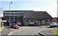
Avalon Court, St Julians, Newport
by Jaggery
Located on Avalon Drive. Built in 1981, managed by Newport City Council.
|

|
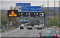
At Junction 25, heading west on the M4
by Rob Purvis
|

|
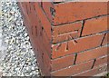
Ordnance Survey Cut Mark
by Adrian Dust
This OS cut mark can be found on St Julius & St Aaron's Church. It marks a point 28.813m above mean sea level.
|
Explore more images in this square: | View Filtering options | View all 352 images page by page >>> |
|