near to Duntisbourne Leer, Gloucestershire, England
Coverage
We have
16 images
in grid square SO9808
Maps
TIP: Click the map for more Large scale mapping
Tip: Click the map to open the coverage map
Sample images
Breakdown list
A sample of 12 photos from 16
for SO9808
- View this square in the Browser >>>

|
Underpass under the A417
As can be seen from the double bridge the A417 is a dual carriageway. It follows Ermin Way, a Roman road and was upgraded to a dual carriageway about ten years ago.
|

|
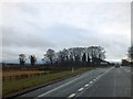
A417 - Duntisbourne Leer junction bridge
by J Whatley
|
|
Slip road from A417 to Duntisbourne Leer
by David Smith
The road leads to an underpass. The trees screen a footpath which comes from the north and then follows the edge of the A417
|

|
Fork in Crabtree Lane |

|
Northbound A417 |
|
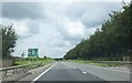
A417, Duntisbourne Leer junction
by Roy Hughes
|
|
A417 exit for Duntisbourne Leer
The road is still running along the track of Ermin Way.
|

|
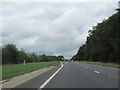
A417 just south of Duntisbourne Junction
by John Firth
Coordinates from Where's the path. Just here the trees encroach onto the grass verges
|

|
Bridges under the A417
A pair of bridges carrying the A417 dual carriageway near the village of Duntisbourne Leer.
|
|
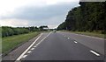
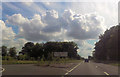
The A417 one third of a mile before services
by Ruth Riddle
Looking north-west as the straight modern road following the course of the Roman Ermin Way passes Field's Farm.
|

|
Track and byway to Woodmancote
Track and byway across farmland to the village of Woodmancote.
|
|
Junction for Duntisbourne Leer
by John Firth
|
Explore more images in this square: | View Filtering options | View all 16 images page by page >>> |
|