near to Llanvetherine, Monmouthshire/Sir Fynwy, Wales
Coverage
We have
46 images
in grid square SO3416
Maps
TIP: Click the map for more Large scale mapping
Tip: Click the map to open the coverage map
Sample images
Breakdown list
A sample of 12 photos from 46
for SO3416
- View this square in the Browser >>>
|
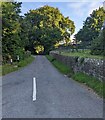
Road towards St David's Church, Llanddewi Skirrid, Monmouthshire
by Jaggery
Ahead for this Link church in the Church in Wales Diocese of Monmouth.
|
|
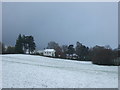
Grazing, Llanddewi Skirrid
by JThomas
Looking towards Llanddewi House.
|
|
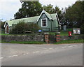
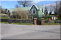
Entrance to Llanddewi Skirrid Village Hall
by Jaggery
Facing the B4521 Old Ross Road, the entrance leads to the corrugated iron sheeting building dating from the 1880s. Grade II listed in 1998 as a rare example of a well designed and largely unaltered late 19th century prefabricated iron hall.
|
|
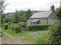
Middle Cottage
Looking west with the ridge of Ysgyryd Fawr in the distance. This property has a logical name, being the second of three cottages along this track.
|
|
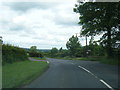
Old Ross Road junction near Parsonage Farm
by Colin Pyle
|
|
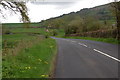
Going west along the B4521 at Llanddewi Skirrid
by Roger Davies
This is an agricultural area east of Abergavenny. The lower slopes of Skirrid Fawr can be seen in the background on the right
|
|
Village Hall at Llanddewi Skirrid |
|
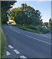
Old Ross Road, Llanddewi Skirrid, Monmouthshire
by Jaggery
Looking to the SE up the B4521 Old Ross Road.
|
|
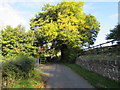
Dominant tree, Llanddewi Skirrid
by Jaggery
Alongside and above the unnamed road from Old Ross Road to St David's Church. Link
|
|
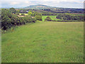
Farmland east of Llanddewi Skirrid
Looking north-east along the route of the public footpath. The dome of Graig Syfyrddin on the horizon.
|
|
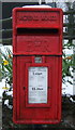
Close up, Elizabeth II postbox on Old Ross Road, Llanddewi Skirrid
by JThomas
Postbox No. NP7 100.
See SO3416 : Elizabeth II postbox on Old Ross Road, Llanddewi Skirrid for wider view.
|
|
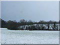
Grazing, Llanddewi Skirrid
by JThomas
Looking down a valley from the B4521.
|
Explore more images in this square: | View Filtering options | View all 46 images page by page >>> |
|