near to Horbury, Wakefield, England
Coverage
We have
163 images
in grid square SE3118
Maps
TIP: Click the map for more Large scale mapping
Tip: Click the map to open the coverage map
Sample images
Breakdown list
A sample of 12 photos from 163
for SE3118
- View this square in the Browser >>>
|
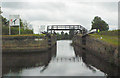
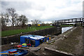
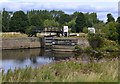
Thornes Flood Lock from below
by Mike Todd
Aire and Calder Navigation. River Calder lies just the other side of gates and bridge
|
|
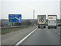
Junction 39, M1 southbound
by Pauline E
Exit at the Cedar Court Roundabout, SW of Wakefield city centre.
|
|
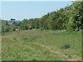
Perimeter path, western lake, Calder Park
The distant blue sign tells southbound drivers on the M1 that they are approaching junction 39.
|
|
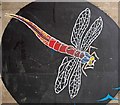
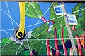
Dragonfly mural
On a M1 underpass.
|
|
Cycleway mural
by Oxana Maher
This mural is to be found at the entrance to the tunnel which conducts the Wakefield to Horbury cycleway under the M1. The rhubarb background serves as a reminder that this is "Rhubarb Triangle" country, where a large proportion... (more)
|
|
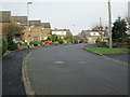
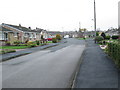
Pennine Close - Cumbrian Way |
|
Thornes Flood Lock, Calder & Hebble Navigation (set of 2 images)
by Ian S
|
|
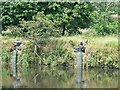
Fishing on the River Calder, Wakefield
by Rich Tea
Near to Flood Lock
|
|
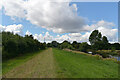
Path by The River Calder, Calder Park Wetlands Nature Reserve, Wakefield
by habiloid
|

|
Horbury Underpass of Graffiti
South side image cluster #05 of 12 (numbering east to west) - detail.
|
|
Calder and Hebble Navigations
by Bobby Clegg
Thornes Flood Lock at the west entrance to Thornes Cut. Viewed from the Calder riverside footpath west of Boat House Farm in Thornes.
|
|
Pentland Grove - Cumbrian Way |
Explore more images in this square: | View Filtering options | View all 163 images page by page >>> |
|