near to Gunnerside, North Yorkshire, England
Coverage
We have
152 images
in grid square SD9598
Maps
TIP: Click the map for more Large scale mapping
Tip: Click the map to open the coverage map
A sample of 12 photos from 152
for SD9598
- View this square in the Browser >>>
|
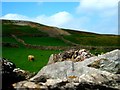
White Hill & Barf End Mine |
|
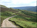
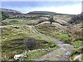
Track at Potting
Track running from Whin Hall to Barf End near Potting.
|
|
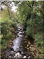
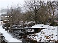
Gunnerside Beck at Gunnerside |
|
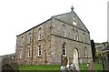
Gunnerside Methodist Church
This Church is almost on the western boundary of the O/S grid which it occupies, to the south of centre.
|
|
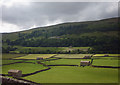
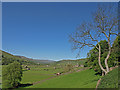
Fields and their barns at Gunnerside
by Karl and Ali
Emerald fields lit by passing shafts of sun.
|
|
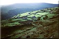
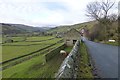
Looking down to Bents
The fellside above the mouth of Gunnerside Gill. The area where the cars are parked is known as Bents, as is the house to the left of the cars. Swaledale stretches westwards towards Muker and Lovely Seat.
|
|
Potting
An view over Potting towards Gunnerside Gill taken on an evening mountain bike ride towards the end of 1992
|
|
Potting Ford
by John Walton
This minor ford near Gunnerside is found on the bridleway leading up to Potting.
|
|
Disused bridge across Gunnerside Gill
This bridge to farm buildings seems to have been replaced by a ford just downstream.
|
|
Approaching Gunnerside
by Russel Wills
From the east.
|
|
Gunnerside, Swaledale
by wfmillar
Looking over Gunnerside Bottoms.
|
|
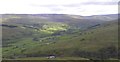
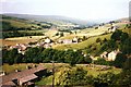
Gunnerside and Swaledale
Looking west from Lodge Green. From a view point very close to Peter McDermott's image taken 12 years later SD9598 : Gunnerside, but looking a little more to the north.
|
Explore more images in this square: | View Filtering options | View all 152 images page by page >>> |
|