near to Gunnerside, North Yorkshire, England
Coverage
We have
49 images
in grid square SD9497
Maps
TIP: Click the map for more Large scale mapping
Tip: Click the map to open the coverage map
A sample of 12 photos from 49
for SD9497
- View this square in the Browser >>>
|
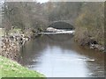
Goosander on the Swale
By Gunnerside Great [or New] Bridge.
|
|
The River Swale (set of 2 images) |
|
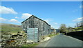
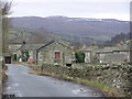
Barn on the B6270 near Satron Farm
by JThomas
|
|
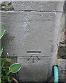
Benchmark on 'Stable Cottage' in Satron
Ordnance Survey cut mark benchmark described on the Bench Mark Database at Link
|
|
Satron : Swaledale |

|
Limekiln near Gunnerside
In the 18th and 19th centuries, when lime was extensively used on acid clay soil to improve cultivation, lime kilns were widespread. Beehive shaped, with a hole in the top, kilns were usually built on the sides of steep hills and against... (more)
|
|
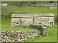
Barn at Gunnerside
Large 'double' barn straddling a wall and serving two pastures at Gunnerside.
|

|
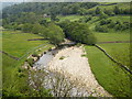
River Swale
by Russel Wills
Viewed under the bridge at Gunnerside.
|
|
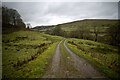
Track into fields below Satron
The track leads into an area with half a dozen fields enclosed by a meander of the River Swale (down the slope to the right) between Satron and Gunnerside bridge. The wall on the left marks the course of the main B6270 Swaledale road whilst... (more)
|
|
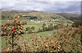
Swaledale
Looking towards Gunnerside. The trees in the centre mark the line of the River Swale.
|
|
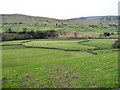
Field within a field
Jigsaw pastures in a bend of the Swale.
|
|
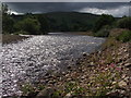
Approaching storm, Swaledale
by Bob Edmonds
|
Explore more images in this square: | View Filtering options | View all 49 images page by page >>> |
|